Upper Mississippi River Climate Summary for November 2025:
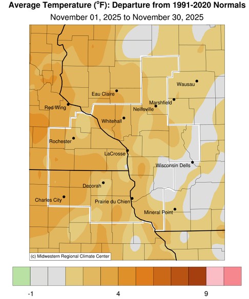
Temperatures - Near to Above Normal
- During November 2025, average temperatures ranged from 32.9°F near Owen, WI (COOP) to 39.5°F at Decorah, IA (COOP) and Guttenberg Lock & Dam 10 (COOP).
- Temperature anomalies ranged from 0°F to 4°F warmer than normal.
- The warmest temperature was 71°F on November14 in Decorah, IA (COOP) and near Steuben, WI (COOP).
- The coldest temperature was 3°F at Sparta Fort McCoy, WI (ASOS) on November 30.
|
 |
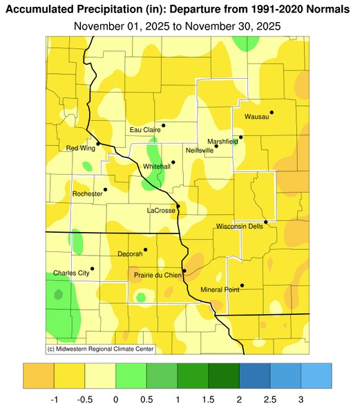
Precipitation - Mainly Below Normal
- Precipitation ranged from 0.88" at Boscobel, WI (ASOS) (CoCoRaHS) to 2.60" at Winona Dam 5A, MN (COOP).
- Precipitation anomalies ranged from 1.5" drier than normal to 0.5" wetter than normal.
- The wettest day from November 29 to November 30 when 1.25" of precipitation fell at Winona Dam 5A, MN (COOP).
|
 |
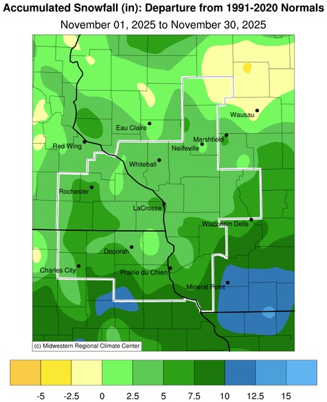
| Snowfall - Above Normal |
|
- Snowfall ranged from 2" near Altura, MN (COOP) to 13.7" near Oelwein, IA (COOP).
- Snowfall anomalies ranged from 0" to 12.5" snowier than normal.
- The snowiest day from November 29 to November 30 when 11" of snow fell near Harpers Ferry, IA (CoCoRaHS).
|
|
 |
Below are the November 2025 climate summaries for La Crosse, WI, and Rochester, MN.
La Crosse, WI
November 2025 was Warmer and Drier than Normal for La Crosse, WI
...November 2025 Highlights...
Temperatures - Warmer than Normal
- During November, La Crosse Regional Airport had an average temperature of 38.3°F. This was 0.7°F warmer than the 1991-2020 normal of 37.6°F.
- The average high temperature was 46.7°F. This was 0.9°F warmer than the 1991-2020 normal of 45.8°F.
- The average low temperature was 29.9°F. This was 0.4°F warmer than the 1991-2020 normal of 29.5°F.
- The warmest high temperature was 65°F on November 14.
- The coldest high temperature was 27°F on November 29.
- The warmest low temperature was 41°F on November 24.
- The coldest low temperature was 15°F on November 30.
Precipitation - Drier than Normal
- During November, 1.18" of precipitation fell at La Crosse Regional Airport.
- This was 0.67" below the 1991-2020 normal of 1.85".
- The wettest day was on November 29 when 0.41" of precipitation fell.
- Measurable precipitation fell on 8 days and trace amounts fell on another 6 days.
Snowfall - 20th Snowiest
- During November, 8.2" of snow was measured by the official snow observer near La Crosse Regional Airport. This was 4.1" above the 1991-2020 normal of 4.1". This was the 20th snowiest November. This was the most snow in November since 1996 (12.2" - 6th most).
- The snowiest day was on November 29 when 5.2" of snow fell. This was the 16th largest 1-day November snowfall. It was the largest one-day snowfall since December 19, 2024 (6.6") and the largest one-day November snowfall since November 23, 1991 (5.4" - 15th largest single-day November snowfall).
- All of the snow (8.2") this month fell on November 29-30. This 2-day November snowfall was the 7th largest in November. This was the largest 2-day snowfall since April 16-17, 2023 (9.5") and the greatest 2-day November snowfall since November 22-23, 1991 (14" - largest November 2-day snowfall).
- Measurable snow fell on 2 days and trace amounts fell on 4 days.
Mississippi River - Below Average
- Average 7 AM stage was 4.97 feet. This was the lowest November average since 2012 (4.86 feet).
- This was 0.48 feet below the long-term average (1937-2025) of 5.45 feet.
- The highest 7 AM stage was 5.16 feet on November 11. The highest 7 AM November stage was 10.68 feet on November 1, 2019.
- The lowest 7 AM stage was 4.81 feet on November 26. The lowest 7 AM November stage was 3.82 feet on November 29 and November 30, 1938.
...November 2025 Records...
...Looking Ahead to December...
- The normal high temperature in La Crosse starts at 38°F on December 1st and falls to 26°F by the end of the month. The normal low temperature starts off at 23°F on the 1st and falls to 10°F by the end of the month. The warmest December temperature on record is 69°F on December 15, 2021, and the coldest is -37°F on December 24, 1872.
- The normal mean temperature for December is 25.1°F. La Crosse’s warmest December occurred in 1877 with an average temperature of 38.9°F, and their coldest December occurred in 1983 with an average temperature of 6.4°F.
- The normal December precipitation is 1.49". The wettest December occurred in 2015 with 4.93" of precipitation and the driest December occurred in 1943 with just 0.01". The wettest December day occurred on December 13, 2015, when 1.71" of precipitation fell.
- The normal December snowfall is 10.9" (2nd snowiest month). The snowiest December occurred in 2008 with 32.7" of snow and the least snow was a trace in 1943, 1979, and 2006. The snowiest December day occurred on December 7, 1927 (La Crosse's snowiest day), when 16.7" of snow fell.
Rochester, MN
November 2025 was Warmer and Drier than Normal at Rochester MN
...November 2025 Highlights...
Temperatures - Warmer than Normal
- During November, Rochester International Airport had an average temperature of 36.2°F. This was 2.6°F warmer than the 1991-2020 normal of 33.6°F.
- The average high temperature was 44.2°F. This was 2.5°F warmer than the 1991-2020 normal of 41.7°F.
- The average low temperature was 28.3°F. This was 2.7°F warmer than the 1991-2020 normal of 25.6°F.
- The warmest high temperature was 69°F on November 14.
- The coldest high temperature was 22°F on November 30.
- The warmest low temperature was 38°F on November 24.
- The coldest low temperature was 13°F on November 28.
Rainfall - Drier than Normal
- During November, 1.52" of precipitation fell at Rochester International Airport.
- This was 0.28" below the 1991-2020 normal of 1.80".
- The wettest day was on November 29 when 0.50" of precipitation fell.
- Measurable precipitation fell on 10 days and trace amounts fell on another 3 days.
Snowfall - 17th Snowiest
- During November, a 9.7" of snow was measured by the official snow observer near Rochester International Airport.
- This was 5.2" below the 1991-2020 normal of 4.5".
- This was the 17th snowiest November and the snowiest since 2019 (13.1").
- The snowiest day was November 29 when 7.6" of snow fell. This not only easily surpassed the previous snow record for the day (3.8" in 1988), but it was the 5th largest one-day November snowfall. It was the largest one-day snowfall since March 15, 2021 (7.9"), and the largest November one-day snowfall since November 10, 2006 (10.5").
- On November 29-30, 8.2 inches of this snow fell. This was 8th largest 2-day November snowfall. This was the largest 2-day snowfall since February 23-24, 2019 (12.1") and the greatest November 2-day snowfall since November 10-11, 2006 (10.5" - 5th largest November 2-day snowfall).
- Measurable snow fell on 6 days and trace amounts fell on another 2 days.
...November 2025 Records...
Daily...
- November 14 - Record High of 69°F - Previous Record was 68°F in 1990
- November 29 - Snow - 7.6" - Previous Record was 3.8" in 1988
...Looking Ahead to December...
- The normal high temperature in Rochester starts off at 34°F on December 1st and falls to 24°F by the end of the month. The normal low temperature starts off at 19°F on the 1st and falls to 9°F by the end of the month. The warmest December temperature on record is 64°F on December 4, 2017, and December 15, 2021, and the coldest is -33°F on December 19, 1983.
- The normal mean temperature for December is 20.8°F. Rochester’s warmest December occurred in 1931 with an average temperature of 30.7°F, and its coldest December occurred in 1983 with an average temperature of 2.9°F.
- The normal December precipitation is 1.28". The wettest December occurred in 2010 with 3.68" of precipitation and the driest December occurred in 1943 with only a trace. This tied March 1910 and June 1910 for their driest month. The wettest December day occurred on December 11, 2010, when 1.36" of precipitation fell.
- The normal December snowfall is 12.4". The snowiest December occurred in 2010 with 41.3" of snow. This was their snowiest month. The least snow was a trace in 1913 and 1943. The snowiest December day occurred on December 11, 2010, when 15" of snow fell.


 Weather Story
 Weather Map
 Local Radar