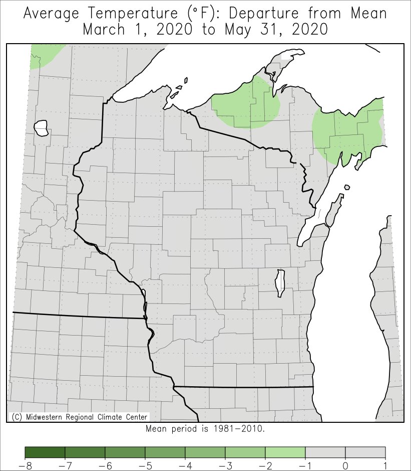
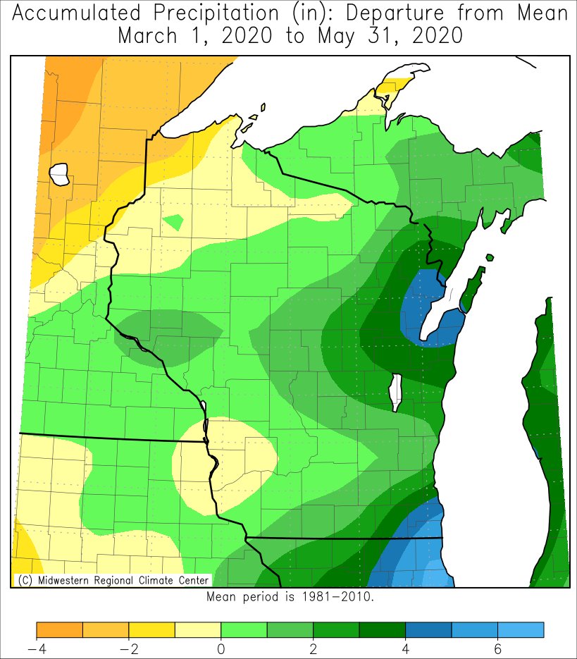
The Upper Mississippi River Valley saw near-normal temperatures during meteorological spring (March 1-May 31). With the exception of southwest Wisconsin and Mitchell and Floyd counties in northeast Iowa, it was wetter-than-normal spring. Snowfall was below-normal across the region this spring.
 |
 |
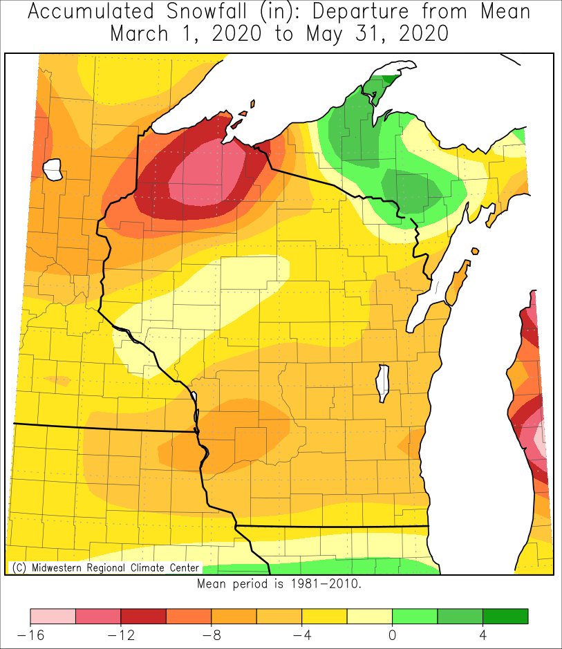 |
| Temperature Anomalies | Precipitation Anomalies | Snowfall Anomalies |
More specifics for La Crosse WI and Rochester MN can be found below.
The meteorological spring of 2020 was warmer (1.2°F warmer-than-normal) and drier-than-normal (1.06" drier-than-normal) at La Crosse Regional Airport. It was the warmest spring since 2017 (49°F) and driest spring since 2010 (6.26"). More details on these statistics can be found below.
Temperatures -
From March 1st through May 31st, La Crosse Regional Airport had an average temperature of 48.8°F. This was 1.2°F warmer than the 1981-2010 normal of 47.6°F. The table below contains the monthly temperatures and their departures from normal for the spring of 2020.
Spring 2020 Temperatures
in La Crosse WI
Average Departure
Month Temperature from Normal
----- ----------- -----------
March 40.0 degrees +5.5 degrees - 12th Warmest
April 47.0 degrees -1.6 degrees
May 59.5 degrees -0.2 degrees
Spring 48.8 degrees +1.2 degrees
Precipitation -
From March 1st through May 31st, La Crosse Regional Airport received 7.84" of precipitation. This was 1.06" drier than the 1981-2010 spring normal of 8.90". This was only the 5th spring since 2000 to be drier-than-normal. The table below contains the monthly precipitation totals and their departures from normal for the spring of 2020.
Spring 2020 Precipitation
in La Crosse WI
Precipitation Departure
Month Total from Normal
----- ------------- -----------
March 2.93 inches +0.89 inches
April 1.63 inches -1.71 inches
May 3.28 inches -0.24 inches
Spring 7.84 inches -1.06 inches
Snowfall -
From March 1st through May 31st, the snow observer near La Crosse Regional Airport recorded 3.9". This was 4.9" less than the 1981-2010 normal of 8.8". Since 2000, 12 springs have had lower than normal snowfall. The table below contains the monthly snowfall totals and their departures from normal for the spring of 2020.
Spring 2020 Snowfall
in La Crosse WI
Snowfall Departure
Month Total from Normal
----- ------------- -----------
March 1.4 inches -5.7 inches - 18th Least
April 2.5 inches +0.8 inches
May 0.0 inches 0.0 inches
Spring 3.9 inches -4.9 inches
The meteorological spring of 2020 was slightly colder (0.8°F colder-than-normal) and wetter-than-normal (0.58" wetter-than-normal) at Rochester International Airport. It was the warmest spring since 2017 (45.1°F) and driest spring since 2018 (9.28"). More details on these statistics can be found below.
Temperatures -
From March 1st through May 31st, Rochester International Airport had an average temperature of 44.9°F. This was 0.8°F colder than the 1981-2010 normal of 45.7°F.
The table below contains the monthly temperatures and their departures from normal for the spring of 2020.
Spring 2020 Temperatures
in Rochester MN
Average Departure
Month Temperature from Normal
----- ----------- -----------
March 35.7 degrees +3.3 degrees - 16th Warmest
April 42.8 degrees -3.9 degrees
May 56.2 degrees -1.9 degrees
Spring 44.9 degrees -0.8 degrees
Precipitation -
From March 1st through May 31st, Rochester International Airport received 9.33" of precipitation. This was 0.58" wetter than the 1981-2010 normal of 8.75". Every spring during the past decade were wetter-than-normal. The table below contains the monthly precipitation totals and their departures from normal for the spring of 2020.
Spring 2020 Precipitation
in Rochester MN
Precipitation Departure
Month Total from Normal
----- ------------- -----------
March 2.51 inches +0.63 inches
April 1.82 inches -1.42 inches
May 5.00 inches +1.37 inches
Spring 9.33 inches +0.58 inches
Snowfall -
From March 1st through May 31st, the snow observer near Rochester International Airport recorded 10.5 inches of snow. This was 1.5" less than the 1981-2010 normal of 12.0". Since 2000, 12 springs have had lower than normal snowfall. The table below contains the monthly snowfall totals and their departures from normal for the spring of 2020.
Spring 2020 Snowfall
in Rochester MN
Snowfall Departure
Month Total from Normal
----- ------------- -----------
March 2.0 inches -6.7 inches - 11th Least
April 8.5 inches +5.2 inches - 11th Snowiest
May Trace 0.0 inches
Spring 10.5 inches -1.5 inches


 Weather Story
 Weather Map
 Local Radar