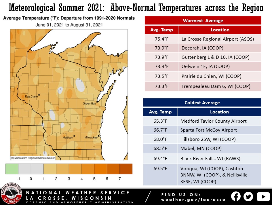
During the meteorological summer of 2021 (June 1-August 31), average temperatures ranged from near-normal to 4 degrees above normal across the Upper Mississippi River Valley. The highest average temperature was 75.4°F at La Crosse Regional Airport. Meanwhile, the coolest average temperature was 65.3°F at Medford Taylor County Airport. August typically has average temperatures of 65 to 72°F.
This was the 2nd hottest summer (75.4°F) at La Crosse, WI. Only 1995 was warmer with an average temperature of 75.7°F. 6 out of the 17 hottest summers have occurred since 2010. It was the 8th hottest summer (71.2°F) at Rochester, MN. It was the hottest summer since 2012 (72.4°F). 7 out of the 20 hottest summers have occurred since 2005.
The hottest temperature was 101°F at Postville, IA on June 6. This was the first 100°F or higher temperature in the Upper Mississippi River since May 15, 2013 (Austin, MN). Other 100°F temperatures occurred in Mondovi, WI on June 10 and near Theilman, MN on June 6 and June 11. Meanwhile, the coldest temperature was 35°F at Sparta Fort McCoy on June 22.
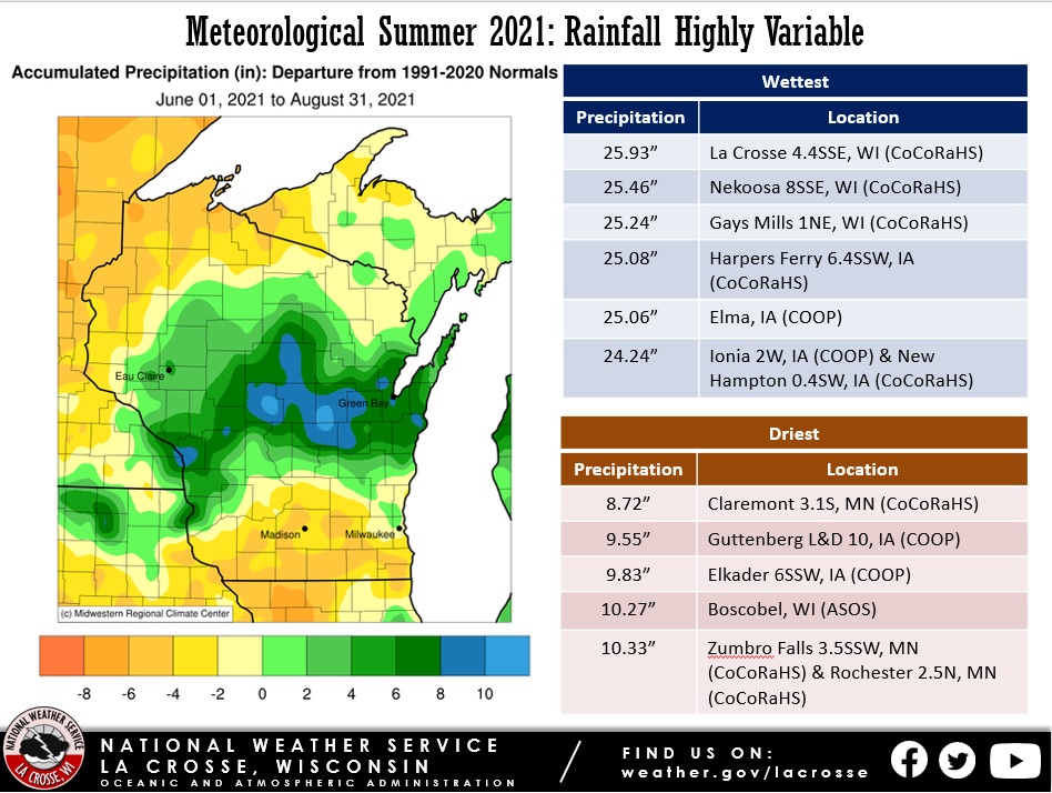
The summer rainfall was highly variable across the region. Rainfall totals ranged from 8.72" near Claremont, MN to 25.93" near La Crosse, WI. Typically rainfall ranges from 12 to 15 inches. It was the second wettest summer at La Crosse Regional Airport with 22.29" of rain. The previous record was 20.93" in 2010.
The summer began with abnormally dry (D0) and moderate drought (D1) covering much of the La Crosse Hydrologic Service Area. By mid-June, severe drought (D2) developed across parts of southeast Minnesota, northeast Iowa, and southwest Wisconsin. During July, above-normal rainfall gradually ended the abnormally dry (D0) and moderate drought (D1) across west-central, central, and north-central Wisconsin. In early August, extreme drought (D3) develop across northeast Iowa. This was the first time that this had been seen in the area since 2012. Above-normal rain in late August helped to end the drought across southeast Minnesota, and much of northeast Iowa and southwest Wisconsin.
Below are the meteorological summer 2021 climate summaries for La Crosse WI and Rochester MN.
During the meteorological summer (June 1st through August 31st) of 2021, it was the wettest summer (22.29" - the previous record was 20.93" in 2010) and the second hottest (75.4°F - only 1995 was hotter with an average of 75.7°F). Six out of the 17 hottest summers have occurred since 2010.
More details are listed below...
Temperatures...
| During meteorological summer, La Crosse Regional Airport had an average temperature of 75.4°F. This was 2.5°F warmer than the 1991-2020 normal of 72.9°F. This made it the 2nd hottest summer. Only 1995 (75.7°F) was hotter. Six out of the 17 hottest summers have occurred since 2010. They were 2010 (tied with 1983 and 2010 for 15th hottest), 2012 (6th hottest), 2016 (tied with 1983 and 2010 for 15th hottest), 2018 (5th hottest), and 2020 (4th hottest). The table below lists the ten hottest summers for the La Crosse Area. | |
Ten Hottest Summers
in La Crosse WI
1873-2021
Average
Rank Temperature Year
---- ----------- ----
1 75.7°F 1995
2 75.4°F 2021
3 75.3°F 1988
4 74.7°F 2020
5 74.5°F 2018
6 74.4°F 2012
7 74.2°F 1980
8 74.0°F 1955
74.0°F 1949
74.0°F 1901
The table below provides a breakdown of the temperature departures from normal for La Crosse WI this summer...
Summer 2021 Temperatures
in La Crosse WI
Departure from
Normal
--------------
June Avg Temp 76.6°F +5.6°F - Hottest
Avg Max Temp 88.2°F +6.5°F - 2nd Hottest
Avg Min Temp 64.9°F +4.5°F - Hottest
July Avg Temp 75.4°F +0.4°F
Avg Max Temp 85.6°F +0.2°F
Avg Min Temp 65.2°F +0.7°F
August Avg Temp 74.3°F +1.5°F - Tied for 11th Hottest
Avg Max Temp 84.6°F +1.4°F - Tied for 18th Hottest
Avg Min Temp 63.9°F +1.6°F - 18th Hottest
Summer Avg Temp 75.4°F +2.5°F - 2nd Hottest
Avg Max Temp 86.1°F +2.6°F - Tied for 3rd Hottest
Avg Min Temp 64.6°F +2.2°F - Tied for 2nd Hottest
Other temperature tidbits this summer...
Rainfall...
During the meteorological summer, La Crosse Regional Airport received 22.29" of rain. This was 9.08" wetter than the 1991-2020 normal of 13.21". This made it the wettest summer. The previous record was 20.93" in 2010.
The table below lists the ten wettest summers for the La Crosse Area.
Ten Wettest Summers
in La Crosse WI
1873-2021
Rank Rainfall Year
---- -------- ----
1 22.29 inches 2021
2 20.93 inches 2010
3 20.32 inches 2007
4 20.12 inches 1990
5 19.88 inches 1993
6 19.82 inches 1981
7 19.38 inches 1899
8 19.24 inches 2016
9 18.08 inches 1928
10 17.89 inches 1953
This was the 6th consecutive summer with above-normal rainfall.
The table below contains the monthly rainfall totals and their departures from normal for this summer.
Summer 2021 Rainfall
in La Crosse WI
Departure
Month Rain Total from Normal
----- ---------- -----------
June 5.30 inches +0.22 inches
July 5.21 inches +0.98 inches
August 11.78 inches +7.88 inches - 2nd Wettest
Summer 22.29 inches +9.08 inches - Wettest
Other rainfall tidbits this summer...
Measurable rain fell on 31 days (33.7%) and trace amounts fell on another 8 days (8.7%).
Sky...
Sea Level Pressure...
Winds...
During the meteorological summer (June 1st through August 31st) of 2021, Rochester had its 8th hottest summer with an average temperature of 71.2°F. 7 out of the 20 hottest summers have occurred since 2005. A total of 12.33" of rain fell. This was 1.33" drier than normal.
More details are listed below...
Temperatures...
| During meteorological summer, Rochester International Airport had an average temperature of 71.2°F. This was 2.5°F warmer than the 1991-2020 normal of 68.7°F. This made it the 8th hottest summer. 7 out of the 20 hottest summers have occurred since 2005. The table below lists the 10 hottest summers for the Rochester Area. | 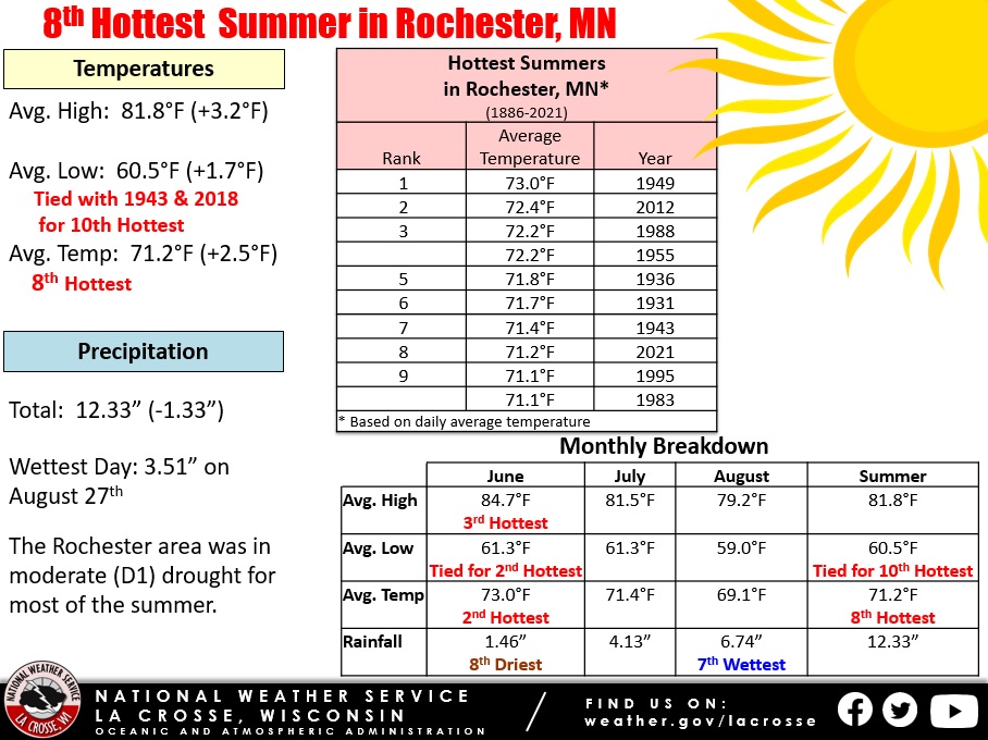 |
Ten Hottest Summers
in Rochester MN
1886-2021
Average
Rank Temperature Year
---- ----------- ----
1 73.0°F 1949
2 72.4°F 2012
3 72.2°F 1988
72.2°F 1955
5 71.8°F 1936
6 71.7°F 1931
7 71.4°F 1943
8 71.2°F 2021
9 71.1°F 1995
71.1°F 1983
The table below provides a breakdown of the temperature departures from normal for Rochester MN this summer...
Summer 2021 Temperatures
in Rochester MN
Departure from
Normal
--------------
June Avg Temp 73.0°F +5.5°F - 2nd Hottest
Avg Max Temp 84.7°F +7.1°F - 3rd Hottest
Avg Min Temp 61.3°F +3.8°F - Tied with 2018
for 2nd Hottest
July Avg Temp 71.4°F +0.9°F
Avg Max Temp 81.5°F +1.2°F
Avg Min Temp 61.3°F +0.5°F
August Avg Temp 69.1°F +0.9°F
Avg Max Temp 79.2°F +1.2°F
Avg Min Temp 59.0°F +0.7°F
Summer Avg Temp 71.2°F +2.5°F - 8th Hottest
Avg Max Temp 81.8°F +3.2°F
Avg Min Temp 60.5°F +1.7°F - Tied with 1943
and 2018 for the
10th Hottest
Other temperature tidbits this summer...
Rainfall...
During the meteorological summer, Rochester International Airport received 12.33" of rain. This was 1.33" drier than the 1991-2020 normal of 13.66 inches.
The table below contains the monthly rainfall totals and their departures from normal for this summer.
Summer 2021 Rainfall
in Rochester MN
Departure
Month Rain Total from Normal
----- ---------- -----------
June 1.46 inches -3.89 inches - 8th Driest
July 4.13 inches -0.06 inches
August 6.74 inches +2.62 inches - 7th Wettest
Summer 12.33 inches -1.33 inches
Other rainfall tidbits this summer...
Measurable rain fell on 28 days (30.4%) and trace amounts fell on another 5 days (5.4%).
Sky...
Sea Level Pressure...
Winds...


 Weather Story
 Weather Map
 Local Radar