Upper Mississippi River Climate Summary for Meteorological Winter 2023-24:
Temperatures - Well Above-Normal
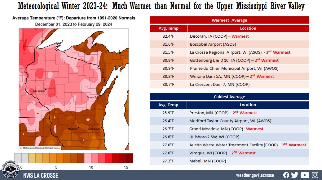
- During the meteorological winter of 2023-24, temperatures in the Upper Mississippi River Valley ranged from 25.9°F at Preston, MN (COOP) to 32.4°F at Decorah, IA (COOP). Temperature anomalies ranged from 8 to 12°F warmer than normal. Many locations had either their warmest or second warmest meteorological winter. There was a 102°F difference between the warmest and coldest temperatures in the Upper Mississippi River Valley. The warmest temperature was 75°F at Northeast Iowa Regional and Oelwein Municipal airports on February 26. Meanwhile, the coldest temperature was -27°F at Theilman, MN (COOP) on January 20.
|
 |
Precipitation - Below Normal
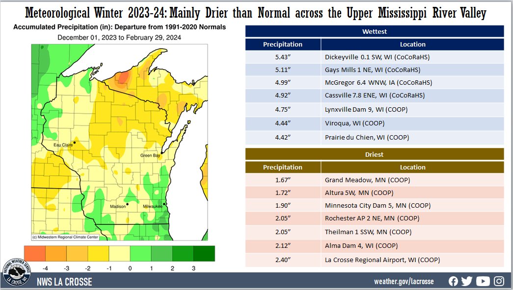
- Precipitation totals ranged from 1.57" at Grand Meadow, MN (COOP) to 5.43" near Dickeyville, WI (CoCoRaHS). Precipitation anomalies ranged from 1.5" drier than normal to 1" wetter than normal. The highest one-day precipitation was 1.22" south of Mondovi, WI (CoCoRaHS) from December 25 through December 26.
- Abnormally dry (D0) to moderate (D1) drought continues north of Interstate 90, and abnormally dry (D0) to extreme (D3) drought lingers elsewhere.
|
 |
Snowfall - Below Normal
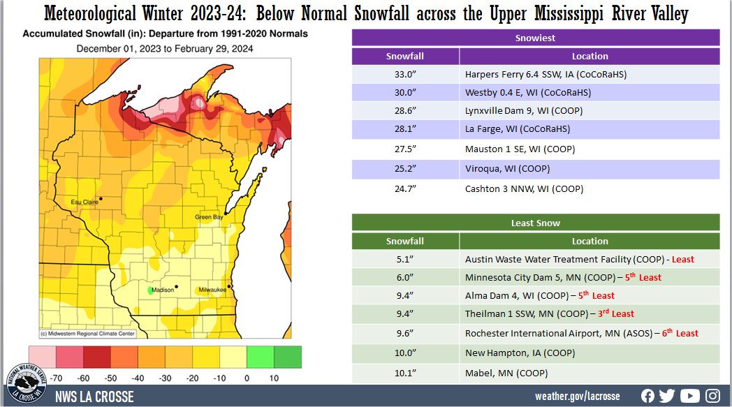
| Snowfall totals were highly variable. They ranged from 5.1" at Austin Waste Water Treatment Facility (COOP) to 33" just southwest of Harpers Ferry, IA (CoCoRaHS). Snowfall anomalies ranged from near normal to 30" below normal. The highest one-day snowfall was 12.5" at La Farge, WI (COOP) from January 12 through January 13. |
 |
Here are more details on the winter for La Crosse WI and Rochester MN...
La Crosse WI...
During the meteorological winter (December 1 through February 29), La Crosse Regional Airport was drier and much warmer than normal. The information below provides more details on these statistics.
Temperatures - 2nd Warmest
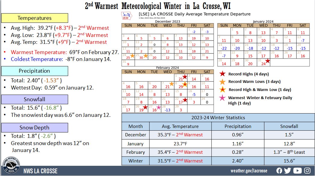
| From December 1 through February 29, the average temperature at La Crosse Regional Airport was 31.5°F. This was 9°F warmer than the 1991-2020 winter normal of 22.5°F. This was the 2nd warmest winter. The only the winter of 1877-78 was warmer with an average temperature of 34.2°F. |
 |
- Below are the 10 warmest meteorological winters.
Warmest Meteorological Winters
in La Crosse WI
1872-2024
Average
Rank Temperature Winters
---- ----------- -------
1 34.2°F 1877-78
2 31.5°F 2023-24
3 29.8°F 1881-82
4 29.2°F 2001-02
5 29.0°F 1997-98
6 27.8°F 1930-31
7 27.0°F 2011-12
8 26.9°F 2016-17
9 26.4°F 2015-16
26.4°F 1931-32
- The average maximum temperature was 39.2°F. This was 8.3°F warmer than the 1991-2020 normal of 30.9°F. This was the 2nd warmest for a winter. The only the winter of 1877-78 was warmer with an average temperature of 40.5°F.
- The average minimum temperature was 23.8°F. This was 9.7°F warmer than the 1991-2020 normal of 14.1°F. This was the 2nd warmest for a winter. The only the winter of 1877-78 was warmer with an average temperature of 27.9°F.
- The table below contains the monthly temperatures and their departures from normal for the winter of 2023-24.
Winter 2023-24 Temperatures
in La Crosse WI
Average Departure
Month Temperature from Normal
----- ----------- -----------
December 35.3°F +10.2°F - 2nd Warmest
January 23.7°F + 4.8°F
February 35.4°F +12.1°F - 2nd Warmest
Winter 31.5°F + 9.0°F - 2nd Warmest
- The warmest high temperature was 69°F on February 27. This tied December 15, 2021, for the warmest temperature in a winter.
- The coldest high temperature was 2°F on January 14.
- The warmest low temperature was 50°F on December 25.
- The coldest low temperature was -8°F on January 14, January 15, and January 20.
- The daily average temperatures were above normal on 77 days (84.6 percent), below normal on 13 days (14.3 percent), and normal on 1 day (1.1 percent).
- The temperature fell to zero or below zero on 9 days. Normally, there are 21 sub-zero temperatures in winter.
Precipitation - Drier than Normal
- La Crosse Regional Airport received 2.40" of precipitation. This was 1.53" drier than the 1991-2020 winter normal of 3.93". The table below contains the monthly precipitation totals and their departures from normal for the winter of 2023-24.
Winter 2023-24 Precipitation
in La Crosse WI
Precipitation Departure
Month Total from Normal
----- ------------- -----------
December 0.96 inches -0.53 inches
January 1.16 inches -0.09 inches
February 0.28 inches -0.91 inches
Winter 2.40 inches -1.53 inches
- The wettest day was on January 12 when 0.59" of precipitation fell.
- Precipitation fell on 35 days (38.5 percent). Measurable precipitation fell on 18 days (19.8 percent) and trace amounts of precipitation fell on 17 days (18.7 percent).
Snowfall - Below Normal
- The snow observer near La Crosse Regional Airport received 15.6" of snow. This was 16.8" below the 1991-2020 normal of 32.4". The table below contains the monthly snowfall totals and their departures from normal for the winter of 2023-24.
Winter 2023-24 Snowfall
in La Crosse WI
Snowfall Departure
Month Total from Normal
----- ------------ -----------
December 1.5 inches -9.4 inches
January 12.8 inches +1.0 inches
February 1.3 inches -8.4 inches - 8th least
Winter 15.6 inches -16.8 inches
- The snowiest day was 6.6" on January 12.
- Snow fell on 23 days (25.3 percent). Measurable snow fell on 10 days (11 percent) and a trace of snow fell on another 13 days (14.3 percent).
Snow Depth - Below Normal
- The official snow observer near La Crosse Regional Airport had an average snow depth of 1.8". This was 2.6" lower than the long-term average (1893-2024) of 4.4".
- The greatest snow depth was 12" on January 14.
- There was snow on the ground on 32 days (35.2 percent) this winter. Measurable snow was on the ground on 26 days (28.6 percent) and trace amounts of snow on the ground on 6 days (6.6 percent).
Winds -
- Highest sustained winds - 35 mph from the northwest on December 18
- Highest wind gust - 48 mph from the northwest on December 18
Sky -
- Clear - 33 days
- Partly Cloudy - 25 days
- Cloudy - 33 days
Barometric Pressure -
- Highest - 30.75" on January 20
- Lowest - 29.23" on February 27
Rochester MN...
During the meteorological winter (December 1 through February 29), Rochester International Airport was drier and much warmer than normal. The information below provides more details on these statistics.
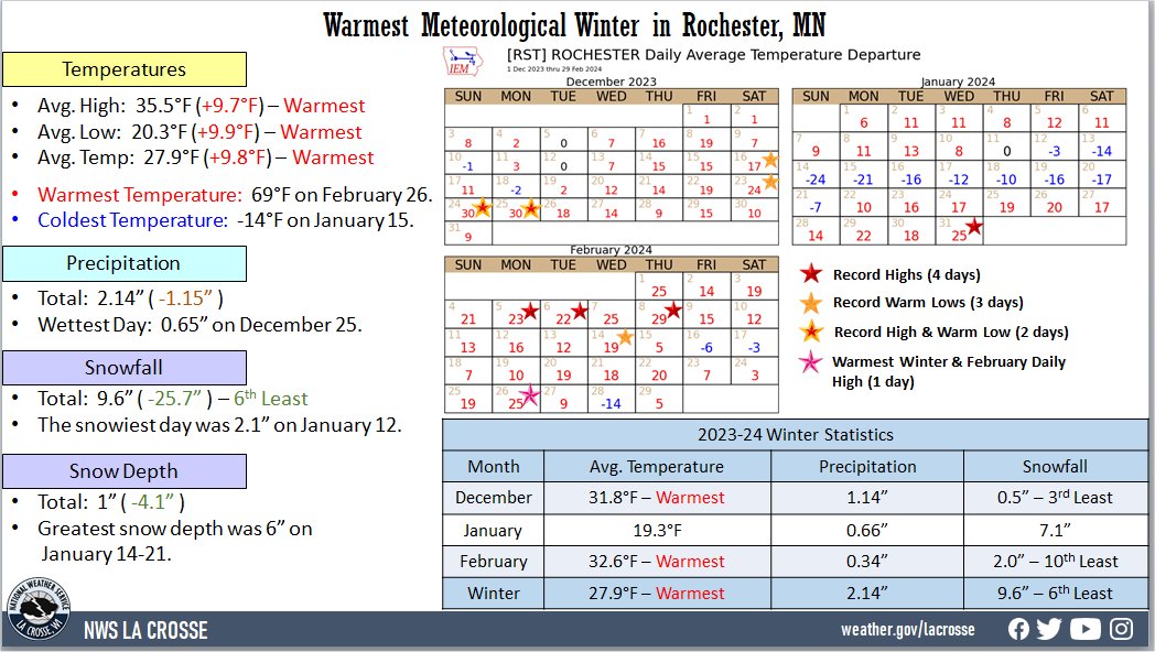
Temperatures - Warmest
- From December 1 through February 29, the average temperature at Rochester International Airport was 27.9°F. This was 9.8°F warmer than the 1991-2020 winter normal of 18.1°F. This was the warmest meteorological winter. The previous record was 26.3°F in 1930-31.
|
 |
- Below are the 10 warmest meteorological winters.
Warmest Meteorological Winters
in Rochester MN
1886-2024
Average
Rank Temperature Winters
---- ----------- -------
1 27.9°F 2023-24
2 26.3°F 1930-31
3 25.5°F 2011-12
25.5°F 2001-02
5 24.7°F 1997-98
6 23.7°F 1986-87
7 23.4°F 1918-19
8 23.2°F 1991-92
9 22.8°F 1931-32
10 22.6°F 1982-83
- The average maximum temperature was 35.5°F. This was 9.7°F warmer than the 1991-2020 normal of 25.8°F. This was the warmest for a meteorological winter. The previous record was 35.3°F during the meteorological winter of 1930-31.
- The average minimum temperature was 20.3°F. This was 9.9°F colder than the 1991-2020 normal of 10.4°F. This was the warmest for a meteorological winter. The previous record was 19.1°F during the meteorological winter of 1997-98.
- The table below contains the monthly temperatures and their departures from normal for the winter of 2023-24.
Winter 2023-24 Temperatures
in Rochester MN
Average Departure
Month Temperature from Normal
----- ----------- -----------
December 31.8°F +11.0°F - Warmest
January 19.3°F + 4.6°F
February 32.6°F +13.9°F - Warmest
Winter 27.9°F + 9.8°F - Warmest
- The warmest high temperature was 69°F on February 26. The warmest high temperature for a meteorological winter.
- The coldest high temperature was -5°F on January 15.
- The warmest low temperature was 44°F on December 24 and December 25.
- The coldest low temperature was -14°F on January 15.
- The daily average temperatures were above normal on 74 days (81.3 percent), below normal on 15 days (16.5 percent), and normal on 2 days (2.2 percent).
- The temperature fell to zero or below on 9 days. Normally, there are 21 sub-zero temperatures in winter.
Precipitation - Below Normal
- Rochester International Airport received 2.14" of precipitation. This was 1.15" drier than the 1991-2020 winter normal of 3.29".
- The table below contains the monthly precipitation totals and their departures from normal for the winter of 2023-24.
Winter 2023-24 Precipitation
in Rochester MN
Precipitation Departure
Month Total from Normal
----- ------------- -----------
December 1.14 inches -0.14 inches
January 0.66 inches -0.33 inches
February 0.34 inches -0.68 inches
Winter 2.14 inches -1.15 inches
- The wettest day was on December 25 when 0.65" of precipitation fell.
- Precipitation fell on 33 days (36.3 percent). Measurable precipitation fell on 20 days (22 percent) and trace amounts of precipitation fell on 13 days (14.3 percent).
Snowfall - 6th Least
The snow observer near Rochester International Airport received 9.6" of snow. This was 25.7" below the 1991-2020 normal of 35.3". This was the 6th least in a meteorological winter and the least since 1967-68 (7.8"). The least in a meteorological winter was 6.4 inches in 1957-58. Below are the 10 least amount of snow in a meteorological winter.
Least Snow in a
Meteorological Winter
in Rochester MN
1886-2024
Rank Snowfall Winter
---- -------- ------
1 6.4 inches 1957-58
2 7.7 inches 1913-14
3 7.8 inches 1967-68
4 8.2 inches 1943-44
5 9.5 inches 1930-31
6 9.6 inches 2023-24
7 9.9 inches 1933-34
8 10.1 inches 1975-76
9 10.5 inches 1956-57
10 11.2 inches 1960-61
- The table below contains the monthly snowfall totals and their departures from normal for the winter of 2023-24.
Winter 2023-24 Snowfall
in Rochester MN
Snowfall Departure
Month Total from Normal
----- ------------ -----------
December 0.5 inches -11.9 inches - 3rd Least
January 7.1 inches -5.1 inches
February 2.0 inches -8.7 inches - 10th Least
Winter 9.6 inches -25.7 inches - 6th Least
- The snowiest day was 2.1" on January 12.
- Snow fell on 26 days (28.6 percent). Measurable snow fell on 13 days (14.3 percent) and a trace of snow fell on another 13 days (14.3 percent).
Snow Depth - Tied for Least
- The official snow observer near Rochester International Airport had an average snow depth of 1". This was 4.1" lower than the long-term average (1938-2024) of 5.1".
- The greatest snow depth was 6" on January 14-21.
- There was snow on the ground on 24 days (26.4 percent) this winter. Measurable snow was on the ground on 23 days (25.3 percent) and trace amounts of snow on the ground on 1 day (1.1 percent).
Winds -
- Highest sustained winds - 38 mph from the south on February 8
- Highest wind gust - 51 mph from the south on February 8
Sky -
- Clear - 34 days
- Partly Cloudy - 27 days
- Cloudy - 30 days
Barometric Pressure -
- Highest - 30.71" on January 20
- Lowest - 29.22" on February 27


 Weather Story
 Weather Map
 Local Radar