Latest aviation discussion:
.AVIATION /06Z SATURDAY THROUGH WEDNESDAY/...
MVFR cigs will rotate around the back side of a low tonight,
affecting all terminals at some point. AVP will have the most
intermittent MVFR cigs while ITH and BGM have the highest
confidence in persistent MVFR cigs. Day time heating and dry air
advecting in aloft will help scatter out the cigs by 18Z. High
pressure building in tonight will cause winds to weaken
considerably after sunset.

Outlook:

Saturday night through Sunday night... Mainly VFR.

Monday through Wednesday...Mainly VFR, but isolated showers
each afternoon may result in brief restrictions.
|
This discussion and more can be found in the Area Forecast Discussion.
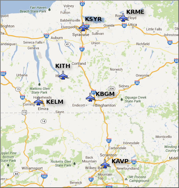
Aviation Forecasts
The National Weather Service Office in Binghamton, NY has responsibility for six Terminal Aerodrome Forecasts or TAFs in Central New York and Northeast Pennsylvania.
Click on a site on the map below to view the latest TAF.
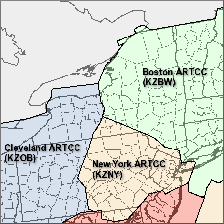
Center Weather Service Unit Products
Three Center Weather Service Unit (CWSU) cover the NWS Binghamton, NY County Warning Area. Click on the map or one of the links below the map to go to the corresponding CSWU website.
Text links...
Decoded/Raw Text
| Location | Sky/Weather | Temperature | Dewpoint Temperature | Relative Humidity | Wind | Pressure | Remarks |
| Binghamton, NY | CLOUDY | 45 | 35 | 68 | N12G37 | 29.85S | |
| Cortland, NY | CLOUDY | 45 | 37 | 76 | NW6 | 29.89S | |
| Dansville, NY | CLOUDY | 50 | 37 | 61 | NW10 | 29.99R | |
| Elmira, NY | CLOUDY | 48 | 35 | 60 | MISG | 29.93R | |
| Ithaca, NY | CLOUDY | 47 | 38 | 71 | NW12G25 | 29.90S | |
| Monticello, NY | CLOUDY | 47 | 35 | 63 | NW15G25 | 29.79S | |
| Penn Yan, NY | CLOUDY | 48 | 37 | 65 | NW12G18 | 29.95R | |
| Rome, NY | CLOUDY | 48 | 40 | 73 | W14 | 29.86R | |
| Syracuse, NY | LGT RAIN | 50 | 41 | 71 | NW16G22 | 29.90S | |
| Hazleton, PA | CLEAR | 50 | 32 | 50 | NW7G20 | 29.87R | |
| Scranton, PA | LGT RAIN | 49 | 33 | 54 | N9 | 29.87R | |
| 400 AM EDT SAT MAY 30 2026 | |||||||
METAR Request form via the Aviation Weather Center. Raw and decoded observations.
​Surface Weather Maps
Miscellaneous

