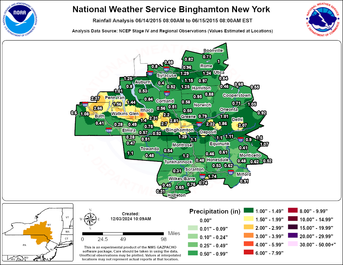
A nearly stationary warm front stretched across parts of central New York on June 14, 2015. A warm, moist airmass was in place with most areas already saturated from rains from the previous few days. Showers and thunderstorms developed and moved slowly across these areas producing very heavy rainfall. Localized flooding occurred in several locations. Below is a map showing estimated rainfall amounts based on radar and observations. The time frame of the map was from 8 am June 14 to, 8 am June 15, 2015.
NOUS41 KBGM 151343
PNSBGM
NYZ009-015>018-022>025-036-037-044>046-055>057-062-PAZ038>040-043-
044-047-048-072-160143-

PUBLIC INFORMATION STATEMENT
SPOTTER REPORTS
NATIONAL WEATHER SERVICE BINGHAMTON NY
943 AM EDT MON JUN 15 2015

THE FOLLOWING ARE OFFICIAL AND UNOFFICIAL OBSERVATIONS TAKEN DURING
THE PAST 4 HOURS. APPRECIATION IS EXTENDED TO HIGHWAY DEPARTMENTS...
COOPERATIVE OBSERVERS...SKYWARN SPOTTERS AND MEDIA FOR THESE REPORTS.
THIS SUMMARY IS ALSO AVAILABLE ON OUR HOME PAGE AT WEATHER.GOV/BGM.

********************STORM TOTAL RAINFALL********************

LOCATION          STORM TOTAL     TIME/DATE   COMMENTS
                     RAINFALL           OF
                     /INCHES/   MEASUREMENT

NEW YORK

...TOMPKINS COUNTY...
   NEWFIELD              4.30   922 AM  6/15  FACEBOOK

PENNSYLVANIA

...SUSQUEHANNA COUNTY...
   GREAT BEND            1.10   910 AM  6/15  TRAINED SPOTTER


**********************24 HOUR RAINFALL**********************

LOCATION              24 HOUR     TIME/DATE   COMMENTS
                     RAINFALL           OF
                     /INCHES/   MEASUREMENT

NEW YORK

...BROOME COUNTY...
   BINGHAMTON (GREATER   2.81   753 AM  6/15  ASOS
   1 ENE BINGHAMTON      2.52   630 AM  6/15  COCORAHS
   BINGHAMTON            2.18   755 AM  6/15  CWOP
   3 NE CHENANGO BRIDGE  2.12   630 AM  6/15  COCORAHS
   ENDWELL               2.10   756 AM  6/15  TRAINED SPOTTER
   1 S JOHNSON CITY      1.75   640 AM  6/15  CWOP
   8 SE WINDSOR          1.73   700 AM  6/15  COCORAHS
   JOHNSON CITY          1.71   759 AM  6/15  CWOP
   WEST CORNERS          1.57   801 AM  6/15  CWOP
   4 WNW SHERMAN         1.49   758 AM  6/15  CWOP
   3 WNW CONKLIN         1.43   801 AM  6/15  CWOP
   2 SSE WHITNEY POINT   1.11   700 AM  6/15  COCORAHS
   3 ENE VESTAL CENTER   1.08   800 AM  6/15  CWOP
   2 SE ENDWELL          0.99   757 AM  6/15  CWOP
   SSE VESTAL            0.99   700 AM  6/15  COCORAHS
   3 E VESTAL            0.98   600 AM  6/15  COCORAHS
   2 E WHITNEY POINT     0.85   742 AM  6/15  TRAINED SPOTTER
   WHITNEY POINT         0.82   700 AM  6/15  USARMY-COE
   WHITNEY POINT DAM     0.82   700 AM  6/15  CO-OP OBSERVER
   VESTAL CENTER         0.76   747 AM  6/15  CWOP

...CAYUGA COUNTY...
   AUBURN                1.33   600 AM  6/15  CO-OP OBSERVER
   CAYUGA LOCK NO 1      1.25   645 AM  6/15  CO-OP OBSERVER
   AURORA RESEARCH FARM  0.53   700 AM  6/15  CO-OP OBSERVER

...CHEMUNG COUNTY...
   ENE VAN ETTEN         0.75   700 AM  6/15  COCORAHS
   1 SSE WEST ELMIRA     0.58   700 AM  6/15  COCORAHS
   CHEMUNG               0.57   700 AM  6/15  CO-OP OBSERVER
   1 ESE ELMIRA          0.57   700 AM  6/15  COCORAHS
   ELMIRA                0.50   700 AM  6/15  CO-OP OBSERVER
   ELMIRA OBSERVER       0.50   700 AM  6/15  CO-OP OBSERVER
   2 SSE ERIN            0.49   756 AM  6/15  CWOP
   1 WNW ELMIRA          0.48   630 AM  6/15  COCORAHS
   3 SSE HORSEHEADS      0.41   700 AM  6/15  COCORAHS
   HORSEHEADS            0.28   640 AM  6/15  COCORAHS
   ELMIRA/CORNING REGIO  0.25   753 AM  6/15  ASOS

...CHENANGO COUNTY...
   2 SW GREENE           1.11   801 AM  6/15  CWOP
   GREENE                0.97   640 AM  6/15  CO-OP OBSERVER
   SHERBURNE             0.95   630 AM  6/15  CO-OP OBSERVER
   1 N SHERBURNE         0.88   708 AM  6/15  RAWS
   1 WNW NORWICH         0.82   749 AM  6/15  CWOP
   1 W NORTH NORWICH     0.81   753 AM  6/15  CWOP
   3 WSW BAINBRIDGE      0.79   613 AM  6/15  COCORAHS
   5 W NORWICH           0.67   700 AM  6/15  COCORAHS
   NORWICH               0.65   700 AM  6/15  CO-OP OBSERVER
   1 NNW OXFORD          0.51   800 AM  6/15  COCORAHS
   2 WSW COLUMBUS        0.28   747 AM  6/15  CWOP

...CORTLAND COUNTY...
   1 ENE CORTLAND        0.68   600 AM  6/15  COCORAHS
   3 SSW CORTLAND        0.63   700 AM  6/15  COCORAHS
   CINCINNATUS           0.58   700 AM  6/15  USARMY-COE
   2 E WILLET            0.55   700 AM  6/15  COCORAHS
   1 NW MARATHON         0.51   700 AM  6/15  COCORAHS

...DELAWARE COUNTY...
   1 W MASONVILLE        2.32   742 AM  6/15  TRAINED SPOTTER
   7 W ANDES             2.07   700 AM  6/15  COCORAHS
   7 W WALTON            1.86   700 AM  6/15  COCORAHS
   2 SE DELHI            1.55   828 AM  6/15  TRAINED SPOTTER
   2 SSE YOUNGS          1.33   754 AM  6/15  CWOP
   7 NNE LONG EDDY       1.11   700 AM  6/15  COCORAHS
   1 W HANCOCK           1.10   600 AM  6/15  COCORAHS
   SIDNEY CENTER RAIN G  1.01   715 AM  6/15  GOES
   5 ESE HOBART          0.92   700 AM  6/15  COCORAHS
   EAST SIDNEY           0.72   700 AM  6/15  CO-OP OBSERVER
   SIDNEY STREAM GAGE    0.57   715 AM  6/15  GOES

...MADISON COUNTY...
   2 ESE CHITTENANGO     1.29   630 AM  6/15  COCORAHS
   3 SE CAZENOVIA        1.25   700 AM  6/15  COCORAHS
   1 S CAZENOVIA         1.15   857 AM  6/15  TRAINED SPOTTER
   NW ONEIDA             1.01   600 AM  6/15  COCORAHS
   2 SW MUNNSVILLE       0.97   700 AM  6/15  COCORAHS
   LAKEPORT              0.96   744 AM  6/15  CWOP
   MORRISVILLE 6 SW      0.60   700 AM  6/15  CO-OP OBSERVER
   W EARLVILLE           0.47   700 AM  6/15  COCORAHS

...ONEIDA COUNTY...
   1 S NEW HARTFORD      1.40   700 AM  6/15  COCORAHS
   NNW VERNON            1.24   700 AM  6/15  COCORAHS
   1 WSW WHITESBORO      1.16   800 AM  6/15  CWOP
   2 WSW HOLLAND PATENT  1.02   700 AM  6/15  COCORAHS
   NEW HARTFORD          1.00   756 AM  6/15  CWOP
   1 WNW HOLLAND PATENT  1.00   700 AM  6/15  COCORAHS
   DEERFIELD             0.99   754 AM  6/15  CWOP
   4 SW ROME             0.97   730 AM  6/15  COCORAHS
   1 ENE CHADWICKS       0.84   756 AM  6/15  CWOP
   3 NW WESTMORELAND     0.83   742 AM  6/15  CWOP
   3 NE CLEVELAND        0.82   758 AM  6/15  CWOP
   5 SSE ROME            0.81   600 AM  6/15  COCORAHS
   4 N WESTMORLAND COOP  0.81   700 AM  6/15  CO-OP OBSERVER
   WESTMORELAND 4 N      0.81   700 AM  6/15  CO-OP OBSERVER
   4 SW CLINTON          0.78   754 AM  6/15  CWOP
   1 SE POINT ROCK       0.71   700 AM  6/15  COCORAHS
   8 E BOONVILLE         0.45   645 AM  6/15  COCORAHS
   BOONVILLE 4 SSW       0.44   700 AM  6/15  CO-OP OBSERVER
   2 SSW BOONVILLE       0.44   700 AM  6/15  CO-OP OBSERVER

...ONONDAGA COUNTY...
   3 S SYRACUSE          1.75   730 AM  6/15  COCORAHS
   2 NW ORAN             1.63   751 AM  6/15  CWOP
   1 ESE CAMILLUS        1.55   758 AM  6/15  CWOP
   SKANEATELES           1.53   748 AM  6/15  CWOP
   1 WSW DE WITT         1.09   700 AM  6/15  COCORAHS
   1 WNW SYRACUSE        1.08   756 AM  6/15  CWOP
   MINOA                 1.03   754 AM  6/15  CWOP
   SYRACUSE HANCOCK INT  0.92   754 AM  6/15  ASOS
   1 NNE EAST SYRACUSE   0.85   754 AM  6/15  CWOP
   SOLVAY                0.83   800 AM  6/15  CWOP
   BALDWINSVILLE         0.80   643 AM  6/15  CO-OP OBSERVER
   BREWERTON BLO LOCK 2  0.68   700 AM  6/15  CO-OP OBSERVER
   1 WSW CICERO          0.66   753 AM  6/15  CWOP
   FAIRMOUNT             0.65   800 AM  6/15  CWOP
   4 NE BALDWINSVILLE    0.65   545 AM  6/15  COCORAHS
   5 NW CLAY             0.63   800 AM  6/15  COCORAHS
   TULLY                 0.52   800 AM  6/15  CWOP
   NORTH SYRACUSE        0.50   759 AM  6/15  CWOP
   2 W OTISCO            0.40   757 AM  6/15  CWOP
   ONONDAGA CREEK NEAR   0.37   745 AM  6/15  GOES

...OTSEGO COUNTY...
   WORCESTER RAIN GAGE   1.05   715 AM  6/15  GOES
   SW EAST WORCESTER     1.00   700 AM  6/15  COCORAHS
   1 WSW HARTWICK        0.88   730 AM  6/15  GOES
   ONEONTA               0.85   700 AM  6/15  CO-OP OBSERVER
   1 NE ONEONTA          0.85   700 AM  6/15  CO-OP OBSERVER
   EDMESTON RAIN GAGE    0.80   715 AM  6/15  GOES
   EMMONS                0.74   700 AM  6/15  CO-OP OBSERVER
   MILFORD RAIN GAGE     0.71   730 AM  6/15  GOES
   1 ESE RICHFIELD SPRI  0.68   700 AM  6/15  COCORAHS
   2 E CHERRY VALLEY     0.55   800 AM  6/15  CWOP
   4 SSE BRIDGEWATER     0.46   700 AM  6/15  COCORAHS
   PLAINFIELD CENTER RA  0.43   730 AM  6/15  GOES

...SCHUYLER COUNTY...
   3 ENE ODESSA          3.76   715 AM  6/15  COCORAHS
   5 NW WATKINS GLEN     3.41   700 AM  6/15  COCORAHS
   2 SE SMITH VALLEY     2.67   700 AM  6/15  COCORAHS
   MECKLENBURG 4 SW      1.58   700 AM  6/15  CO-OP OBSERVER
   4 SW MECKLENBURG      1.58   700 AM  6/15  CO-OP OBSERVER
   6 ESE DUNDEE          1.50   720 AM  6/15  COCORAHS
   EAST STEAMBURG        1.44   708 AM  6/15  RAWS
   ARNOT FOREST          1.40   700 AM  6/15  CO-OP OBSERVER
   6 E DUNDEE            1.40   700 AM  6/15  COCORAHS

...SENECA COUNTY...
   SENECA FALLS          0.94   801 AM  6/15  CWOP
   WATERLOO              0.80   700 AM  6/15  CO-OP OBSERVER

...STEUBEN COUNTY...
   1 E BLOOMERVILLE      2.66   741 AM  6/15  TRAINED SPOTTER
   1 NNW HORNELL         1.08   813 AM  6/15  TRAINED SPOTTER
   5 S SOUTH CORNING     0.76   800 AM  6/15  COCORAHS
   GANG MILLS            0.73   733 AM  6/15  CWOP
   HORNELL ALMOND DAM    0.60   600 AM  6/15  CO-OP OBSERVER
   2 W NORTH HORNELL     0.56   700 AM  6/15  USARMY-COE
   2 ESE ERWINS          0.46   708 AM  6/15  RAWS
   CORNING               0.45   700 AM  6/15  CO-OP OBSERVER
   CORNING OBSERVER      0.45   700 AM  6/15  CO-OP OBSERVER
   5 S SAVONA            0.41   700 AM  6/15  COCORAHS

...SULLIVAN COUNTY...
   2 SW CLARYVILLE       1.50   700 AM  6/15  CO-OP OBSERVER
   1 E GRAHAMSVILLE      1.07   757 AM  6/15  CWOP
   2 ESE LIVINGSTON MAN  0.90   535 AM  6/15  COCORAHS
   3 SW ROCK HILL        0.62   700 AM  6/15  CO-OP OBSERVER
   ROCK HILL 3 SW        0.62   700 AM  6/15  CO-OP OBSERVER
   SULLIVAN COUNTY INTE  0.61   755 AM  6/15  AWOS
   SSW WURTSBORO         0.52   800 AM  6/15  COCORAHS
   2 SW ELDRED           0.48   750 AM  6/15  CWOP
   2 SW BRISCOE          0.41   752 AM  6/15  CWOP
   LONG EDDY             0.29   630 AM  6/15  COCORAHS

...TIOGA COUNTY...
   1 S NEWARK VALLEY     2.70   834 AM  6/15  NWS EMPLOYEE
   2 N CANDOR            2.31   700 AM  6/15  COCORAHS
   NEWARK VALLEY 1 N     2.20   730 AM  6/15  CO-OP OBSERVER
   2 ENE BERKSHIRE       2.20   800 AM  6/15  COCORAHS
   2 SE CANDOR           1.88   700 AM  6/15  CO-OP OBSERVER
   3 ENE OWEGO           1.73   647 AM  6/15  COCORAHS
   WEST CANDOR           1.18   753 AM  6/15  CWOP
   3 ESE APALACHIN       1.15   600 AM  6/15  COCORAHS
   1 WNW TIOGA TERRACE   1.13   800 AM  6/15  CWOP
   3 SE APALACHIN        1.10   800 AM  6/15  COCORAHS
   3 WSW OWEGO           0.52   700 AM  6/15  CO-OP OBSERVER
   OWEGO 3 WSW           0.52   700 AM  6/15  CO-OP OBSERVER
   WAVERLY/SAYRE         0.51   700 AM  6/15  CO-OP OBSERVER

...TOMPKINS COUNTY...
   NEWFIELD              4.30   922 AM  6/15  FACEBOOK
   SE CAROLINE CENTER    1.41   700 AM  6/15  COCORAHS
   CAROLINE CENTER       1.41   829 AM  6/15  TRAINED SPOTTER
   NNE TRUMANSBURG       0.95   645 AM  6/15  COCORAHS
   1 NW GROTON           0.84   700 AM  6/15  COCORAHS
   7 NW LANSING          0.83   800 AM  6/15  COCORAHS
   NORTHWEST ITHACA      0.74   753 AM  6/15  CWOP
   1 E ITHACA TOMPKINS   0.63   756 AM  6/15  AWOS
   1 NE FREEVILLE        0.56   800 AM  6/15  CO-OP OBSERVER
   4 W FREEVILLE         0.55   700 AM  6/15  COCORAHS
   2 NE FREEVILLE        0.52   700 AM  6/15  COCORAHS

...YATES COUNTY...
   5 E NAPLES            2.37   830 AM  6/15  COCORAHS
   LAKEMONT              1.56   800 AM  6/15  CWOP
   3 ESE DUNDEE          1.47   700 AM  6/15  COCORAHS
   5 NNW PENN YAN        1.01   700 AM  6/15  COCORAHS

PENNSYLVANIA

...BRADFORD COUNTY...
   CANTON                1.10   800 AM  6/15  CO-OP OBSERVER
   3 NW OVERTON          0.48   757 AM  6/15  CWOP
   6 ENE ROSEVILLE       0.47   725 AM  6/15  COCORAHS
   3 WNW SAYRE           0.45   700 AM  6/15  COCORAHS
   2 NE RIDGEBURY        0.28   754 AM  6/15  CWOP

...LACKAWANNA COUNTY...
   5 SSW SPRINGBROOK CO  0.80   728 AM  6/15  RAWS
   6 S SPRINGBROOK CORN  0.74   749 AM  6/15  CWOP
   AYLESWORTH CK LAKE    0.55   700 AM  6/15  GOES
   JERMYN                0.48   800 AM  6/15  CWOP
   1 SE MONTDALE         0.46   800 AM  6/15  COCORAHS
   VANDLING              0.46   757 AM  6/15  CWOP
   WINTON                0.31   801 AM  6/15  CWOP
   1 ENE MOOSIC          0.29   758 AM  6/15  CWOP

...LUZERNE COUNTY...
   2 NW WHITE HAVEN      1.18   700 AM  6/15  COCORAHS
   5 ENE BEAR CREEK      0.84   750 AM  6/15  CWOP
   ASHMORE               0.79   755 AM  6/15  CWOP
   5 SE WILKES-BARRE     0.76   635 AM  6/15  COCORAHS
   BEAR CREEK            0.75   751 AM  6/15  CWOP
   FLAT BROOK NR         0.65   700 AM  6/15  GOES
   1 NE PENOBSCOT        0.60   800 AM  6/15  CWOP
   ASHLEY                0.47   800 AM  6/15  CWOP
   1 ESE GLEN LYON       0.45   800 AM  6/15  CWOP
   SE DURYEA             0.40   600 AM  6/15  COCORAHS
   WILKES-BARRE/SCRANTO  0.35   754 AM  6/15  ASOS
   1 E DALLAS            0.31   600 AM  6/15  COCORAHS
   1 E BEACH HAVEN       0.31   530 AM  6/15  COCORAHS

...PIKE COUNTY...
   LOCH LOMOND           0.91   744 AM  6/15  GOES
   HAWLEY                0.62   700 AM  6/15  CO-OP OBSERVER
   HAWLEY 1 E            0.62   700 AM  6/15  CO-OP OBSERVER
   8 WSW MILFORD         0.44   530 AM  6/15  COCORAHS
   1 SSW PORT JERVIS     0.36   756 AM  6/15  CWOP
   2 ENE WESTCOLANG PAR  0.31   703 AM  6/15  CWOP

...SUSQUEHANNA COUNTY...
   MONTROSE              1.30   730 AM  6/15  CO-OP OBSERVER
   7 NE FRIENDSVILLE     1.29   700 AM  6/15  COCORAHS
   5 W NEW MILFORD COOP  1.16   800 AM  6/15  CO-OP OBSERVER
   GREAT BEND            1.10   910 AM  6/15  TRAINED SPOTTER
   ENE MONTROSE          0.98   800 AM  6/15  COCORAHS
   SUSQUEHANNA           0.79   700 AM  6/15  CO-OP OBSERVER
   1 NNE HARFORD         0.77   700 AM  6/15  COCORAHS
   2 N GLENWOOD          0.70   751 AM  6/15  CWOP
   1 S UNIONDALE         0.56   700 AM  6/15  USARMY-COE
   1 NNE AUBURN CENTER   0.54   758 AM  6/15  CWOP
   9 WSW MONTROSE        0.34   700 AM  6/15  COCORAHS

...WAYNE COUNTY...
   1 ESE GOULDSBORO      1.74   758 AM  6/15  CWOP
   WINTERDALE            0.74   800 AM  6/15  CWOP
   LACKAWAXAN RIVER      0.64   730 AM  6/15  GOES
   W. BR. LACKAWAXEN RI  0.61   730 AM  6/15  GOES
   6 SW MILANVILLE (PAR  0.61   810 AM  6/15  CO-OP OBSERVER
   HAWLEY                0.57   745 AM  6/15  USGS
   CHERRY RIDGE 13A      0.53   700 AM  6/15  COCORAHS
   DYBERRY CREEK NEAR    0.45   730 AM  6/15  GOES
   1 E LAKEVILLE         0.35   758 AM  6/15  CWOP
   NE DAMASCUS           0.33   745 AM  6/15  COCORAHS

...WYOMING COUNTY...
   2 ESE ALDOVIN         1.20   745 AM  6/15  USGS
Below is a radar loop from 8:00 AM EDT June 14, 2015 to 8:00 AM EDT June 15, 2015.
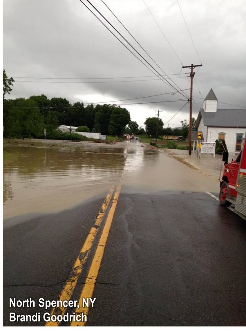
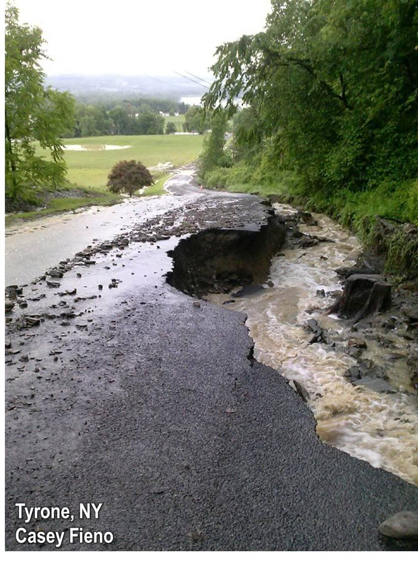
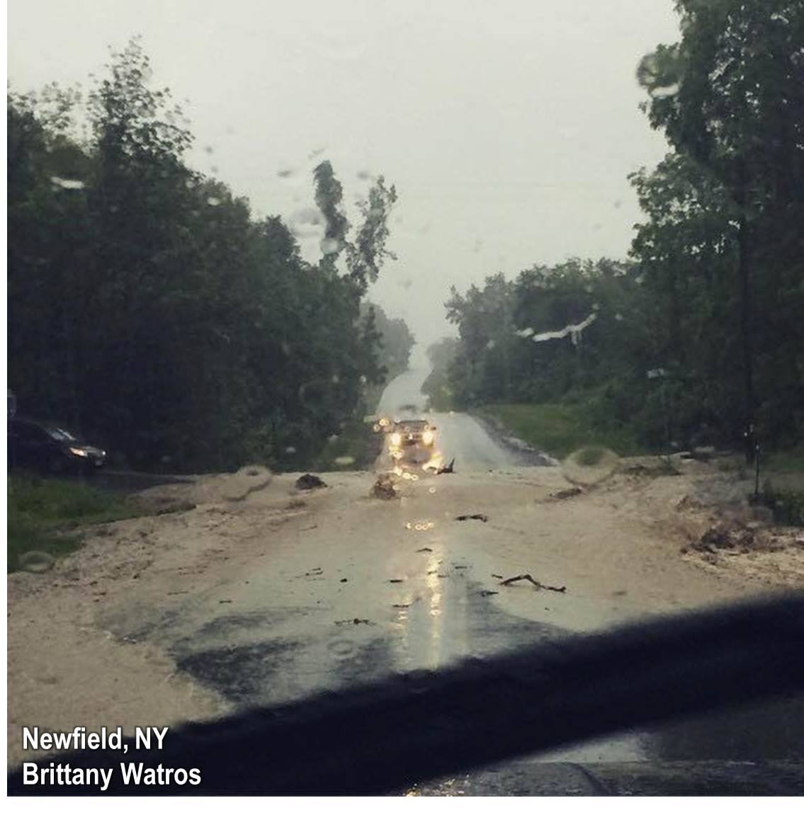
Below are a few photos of the flooding that occurred. More pictures can be found on our Facebook page.
 |
 |
 |
|
Addition Information

