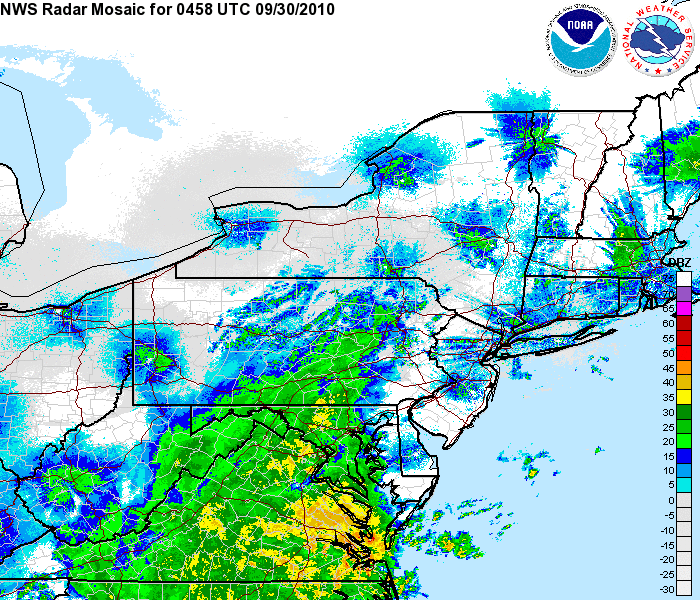
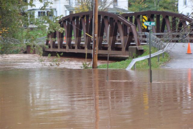
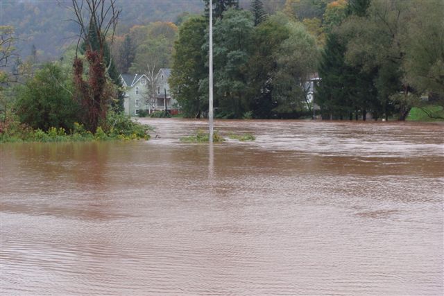
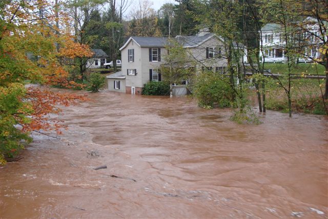
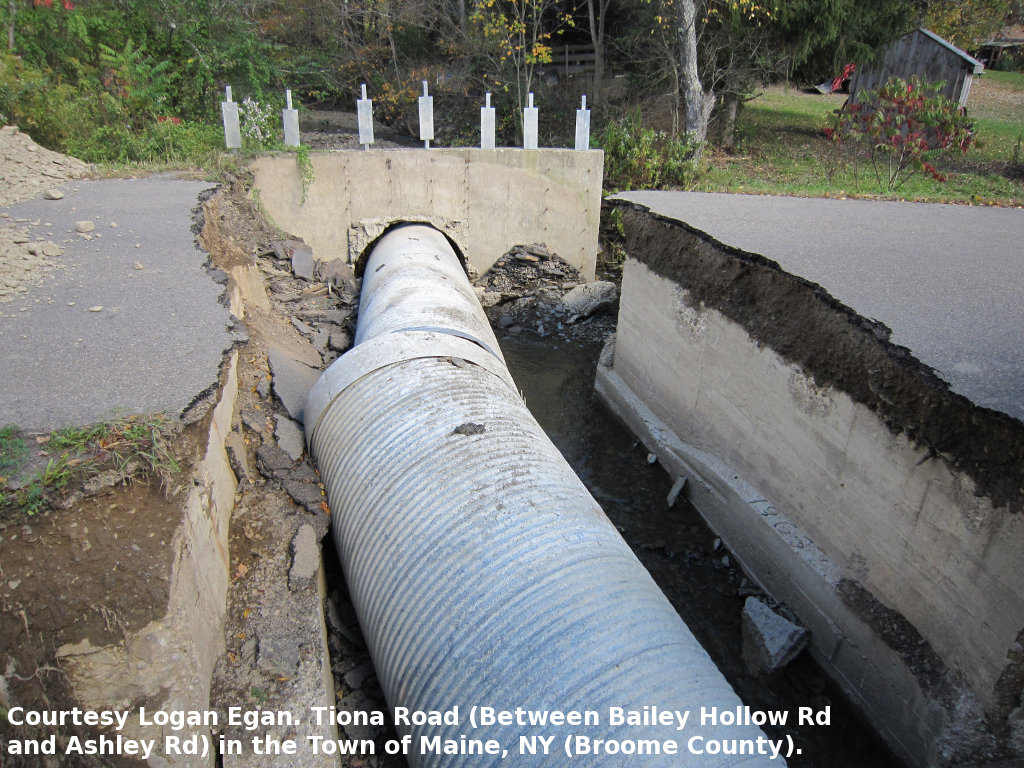
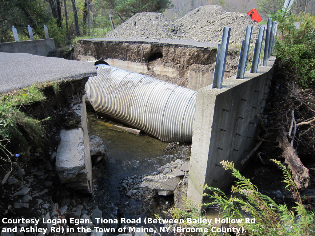
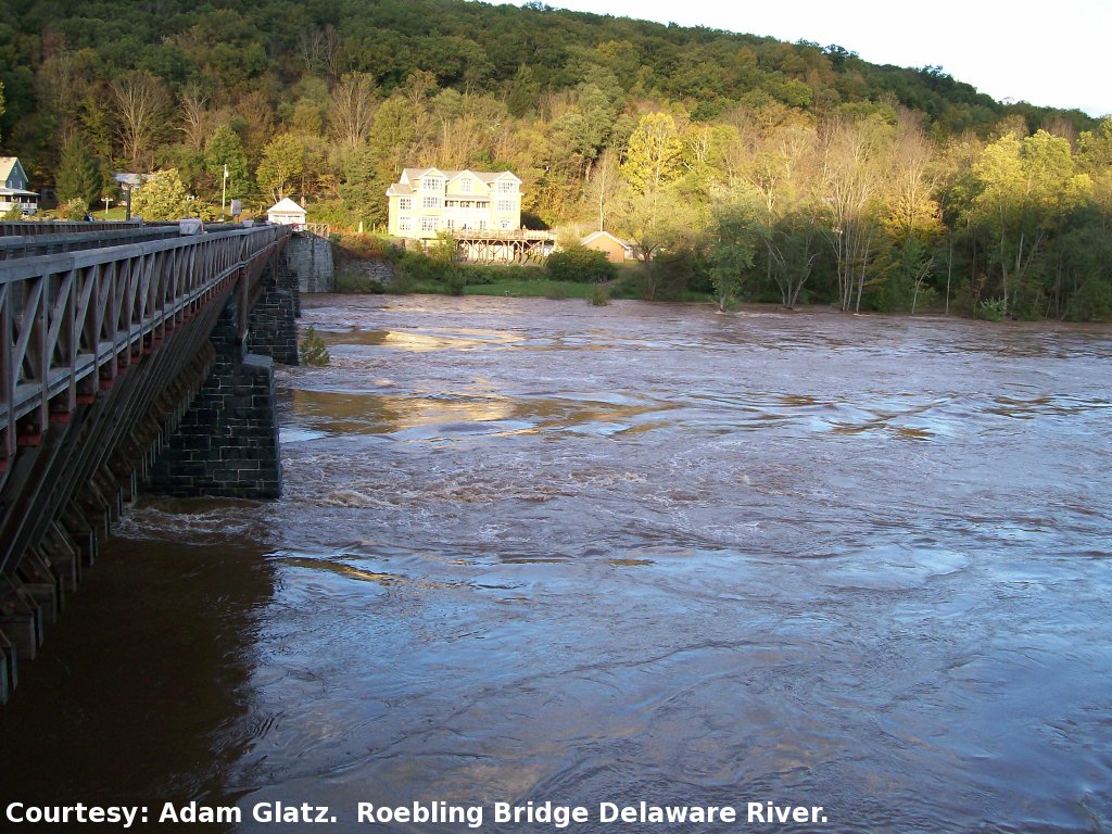
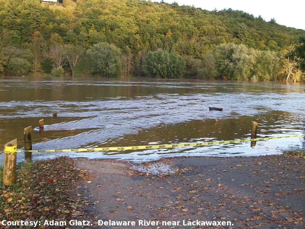
An upper level low pressure system interacting with abundant tropical moisture from the remnants of Tropical Storm Nicole dropped 3 to 6 inches of rain across central New York. Steady and occasionally heavy rain fell across much of the region, causing flash flood problems, as well as minor to moderate flooding of the larger main stem rivers. The rain and flooding began on September 30 and continued into the overnight and next day (October 1), especially across parts of the Catskills. Higher amounts of rain fell across Delaware county in the western Catskills, where 6 to 8 inches of rain caused more serious flood problems.
|
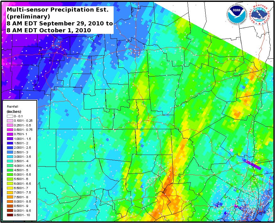
MPE rainfall map. Click for a larger view.
|
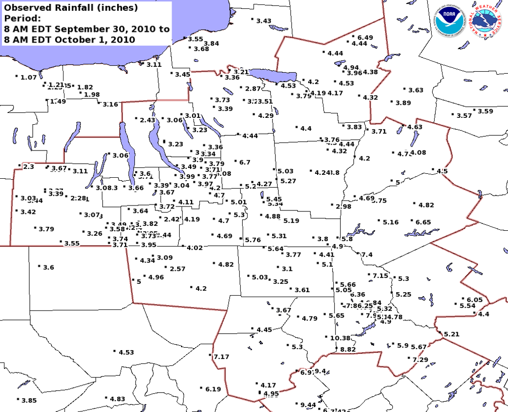
Point data rainfall map. Click for a larger view.
|
The following are unofficial observation of storm total rainfall. The time period is from 8 AM EDT September 29, 2010 to 8 AM EDT October 1, 2010.
Apprecitation is extended to Cooperative, and CoCoRahs observers.
| New York |
| Site |
Amount (inches) |
| Addison |
3.26 |
| Adrian |
3.37 |
| Albany 0.7 E |
4.87 |
| Albany 0.7 SW |
4.60 |
| Altamont 2.7 SSW |
5.49 |
| Andes 6.8 W |
6.65 |
| Apalachin 3.0 ESE |
5.53 |
| Apalachin 2.8 ESE |
5.76 |
| Auburn |
3.01 |
| Auburn 8.3 SSE |
3.23 |
| Aurora 2.8 ESE |
3.35 |
| Aurora Research Farm |
3.23 |
| Averill Park 0.9 WNW |
4.39 |
| Averill Park 1.0 WNW |
4.19 |
| Bainbridge |
2.98 |
| Ballston Spa 2.9 ESE |
5.42 |
| Ballston Spa 4.7 WNW |
3.68 |
| Bath 0.4 N |
3.21 |
| Bath observer |
2.28 |
| Beacon 4.2 ESE |
5.19 |
| Beaver Falls 0.1 SW |
3.59 |
| Berkshire 1.9 ENE |
5.01 |
| Big Flats 1.1 W |
3.84 |
| Big Flats 2.0 W |
4.20 |
| Binghamton |
4.88 |
| Binghamton 1.8 SW |
5.31 |
| Bloomingburg |
4.40 |
| Boonville |
4.44 |
| Boonville 0.2 NW |
6.49 |
| Bradford 3.2 NNE |
3.30 |
| Brewerton blo lock 23 |
3.21 |
| Bridgewater 4.3 SSE |
3.71 |
| Callicoon |
5.30 |
| Camillus 1.0 W |
3.73 |
| Canastota 0.9 S |
3.79 |
| Candor |
4.70 |
| Carmel Hamlet 5.8 N |
5.04 |
| Carthage 2.0 SW |
3.40 |
| Catlin |
3.64 |
| Caton 2.8 SSW |
3.71 |
| Cayuga 3.2 ESE |
3.06 |
| Cayuta 1.6 NW |
3.72 |
| Chenango Forks 3.0 SE |
5.19 |
| Cincinnatus |
5.03 |
| Cohocton |
3.04 |
| Cohocton 4.5 N |
3.67 |
| Cold Springs 8.1 NE |
6.35 |
| Corning 0.7 NNW |
3.49 |
| Corning Observer |
3.58 |
| Cortland |
6.70 |
| Craryville 4.0 NW |
4.84 |
| Dansville 1.0 ENE |
2.30 |
| De Witt 1.4 WSW |
3.29 |
| Delanson 2.5 NNE |
4.41 |
| Delhi 1.5 NNE |
4.82 |
| Delta Dam |
4.94 |
| Deposit |
5.80 |
| Dundee 5.7 ESE |
3.71 |
| Dundee 6.2 E |
3.60 |
| Durhamville 3.5 NNW |
4.20 |
| Earlville 0.4 W |
4.50 |
| Earlville 1.6 NNW |
3.76 |
| East Ithaca 4.7 E |
4.20 |
| East Sidney |
3.75 |
| Elmira 0.7 WNW |
3.70 |
| Elmira 1.3 ESE |
3.94 |
| Elmira 3.2 E |
2.44 |
| Elmira Airport |
3.44 |
| Elmira Observer |
3.95 |
| Enfield 0.8 ENE |
3.04 |
| Erin |
2.42 |
| Fayetteville 1.6 W |
3.51 |
| Floral Park 0.4 W |
3.09 |
| Fonda 5.2 W |
3.59 |
| Fort Plain 0.2 SE |
3.57 |
| Freeville |
4.08 |
| Freeville 2.6 N |
4.00 |
| Freeville 3.7 W |
3.77 |
| Gansevoort 1.3 WNW |
5.08 |
| Glens Falls 4.0 W |
4.55 |
| Griffiss AFB |
3.96 |
| Groton 0.5 NW |
3.79 |
| Groton 3.2 SSW |
3.71 |
| Hammondsport 2.9 ENE |
3.08 |
| Hancock 1.0 W |
7.40 |
| Hartsville |
3.42 |
| Hartwick |
4.78 |
| Holland Patent 1.5 WSW |
4.38 |
| Hopewell Junction 2.4 SSE |
4.97 |
| Hornell 0.5 E |
3.44 |
| Hornell Almond Dam |
3.03 |
| Horseheads 0.7 W |
3.82 |
| Howard |
3.39 |
| Hunts Corners |
5.20 |
| Ilion 0.8 WNW |
3.89 |
| Inlet 2.2 ESE |
3.07 |
| Ithaca |
3.97 |
| Ithaca 2.6 NW |
3.99 |
| Jasper |
3.79 |
| Kingston 1.1 W |
4.59 |
| Lacona 3.6 SSE |
3.43 |
| Lakeport |
4.53 |
| Lansing 6.6 NW |
3.49 |
| Lansing 8.9 N |
3.90 |
| Levittown 0.2 E |
4.10 |
| Little Falls 7.5 NW |
3.63 |
| Locke |
3.60 |
| Locke 0.3 SW |
3.34 |
| Marathon 1.0 NW |
4.27 |
| Marcellus 1.6 E |
3.39 |
| Marlboro 1.9 NNW |
3.57 |
| Martville 4.0 SSE |
3.45 |
| Mecklenburg |
3.39 |
| Minetto 0.1 SE |
3.68 |
| Moravia 2.5 ESE |
3.36 |
| Morris |
4.08 |
| Morrisville |
4.40 |
| New Berlin 1.0 NE |
4.20 |
| New Hartford 0.8 S |
4.32 |
| New Paltz 2.4 S |
3.75 |
| Newark Valley |
5.30 |
| Newfield 2.5 S |
4.11 |
| North Brookfield |
3.83 |
| Norwich |
3.80 |
| Norwich 5.4 W |
4.24 |
| NWS Albany |
5.52 |
| Oneida 0.7 NNE |
4.19 |
| Oneonta |
5.00 |
| Oswego 0.9 WNW |
3.55 |
| Oswego 5.0 ESE |
3.84 |
| Owego |
4.69 |
| Palmyra 1.6 NW |
1.98 |
| Penfield 1.4 ENE |
1.35 |
| Penn Yan |
3.06 |
| Phelps 4.4 NW |
3.16 |
| Phoenix 2.9 SE |
3.36 |
| Pittsford 4.0 SSE |
1.49 |
| Point Rock 0.6 SE |
4.44 |
| Pompey 2.0 NNW |
4.29 |
| Poughkeepsie 4.7 ESE |
2.79 |
| Prattsburg |
3.11 |
| Rensselaerville 2.1 NNW |
5.99 |
| Richfield Springs 0.5 ESE |
4.63 |
| Rochester 5.0 WNW |
1.07 |
| Rochester 5.7 ESE |
1.23 |
| Rochester 5.8 ESE |
1.21 |
| Rock Hill |
5.54 |
| Rome 4.8 SSE |
4.53 |
| Ruby 0.5 NE |
4.31 |
| Saratoga Springs 0.5 S |
5.01 |
| Savona 4.7 S |
3.33 |
| Scotia 1.1 NW |
4.68 |
| Sherburne |
4.32 |
| Sherburne 3.6 NNE |
4.44 |
| Slaterville Springs 1.0 S |
4.70 |
| Smith Valley 1.9 SE |
3.67 |
| South Corning 4.7 S |
3.74 |
| South Salem 2.1 NW |
4.51 |
| Southport 3.8 SSW |
3.95 |
| Stone Ridge 4.9 NNW |
5.46 |
| Syracuse |
2.87 |
| Thurston |
3.07 |
| Tully 1.7 WSW |
4.44 |
| Unadilla |
4.69 |
| Van Etten 0.3 ENE |
4.19 |
| Vernon 0.4 NNW |
4.17 |
| Voorheesville 2.0 NNE |
6.99 |
| Walton |
5.16 |
| Walworth 1.7 SW |
1.82 |
| Waterloo |
2.43 |
| Watkins Glen 4.6 NW |
3.66 |
| Waverly/Sayre |
4.02 |
| West Almond 5.0 SW |
2.13 |
| West Elmira 0.5 SSE |
3.73 |
| Whitney Point 1.7 SSE |
5.34 |
| Whitney Point Dam |
5.45 |
| Willet 1.8 E |
5.27 |
| Windsor |
3.80 |
| Windsor 8.0 SE |
4.90 |
| Wolcott 4.8 N |
3.11 |
| Woodhull |
3.55 |
| Woodridge 5.5 S |
6.05 |
| Worcester 4.0 SSW |
4.50 |
|
| Pennsylvania |
| Site |
Amount (inches) |
| Abbottstown 2.4 N |
4.04 |
| Adamstown 2.5 SSE |
6.56 |
| Aldenville |
6.36 |
| Allentown 4.2 W |
5.62 |
| Ardmore 0.5 NW |
6.93 |
| Aylesworth |
5.65 |
| Bellefonte 4.3 E |
3.85 |
| Bentley Creek |
3.09 |
| Benton 3.4 NE |
7.17 |
| Bloomsburg 3.0 ESE |
6.19 |
| Blue Bell 2.3 NW |
7.27 |
| Bowmanstown 3.0 WSW |
7.27 |
| Chapman 6.6 NW |
7.26 |
| CHERRY RIDGE 13A |
7.94 |
| Collegeville 2.3 N |
7.04 |
| Collegeville 3.0 NE |
8.56 |
| Conyngham 3.9 NE |
4.17 |
| Dingmans Ferry 3.9 WSW |
7.29 |
| Dover 4.2 WSW |
3.31 |
| Doylestown 3.7 W |
5.74 |
| Drexel Hill 0.4 NE |
6.75 |
| Drexel Hill 1.4 NE |
7.00 |
| Dyberry - 19 |
7.11 |
| Dyberry Creek |
6.84 |
| East Smithfield |
2.57 |
| F. E. Walter Dam |
6.97 |
| Fleetwood 2.0 ESE |
7.15 |
| Friendsville 6.8 NE |
5.64 |
| Gilbertsville 0.9 S |
6.01 |
| Glenburn 0.7 ESE |
4.79 |
| Glendon 3.5 S |
6.05 |
| Greencastle 0.3 SSE |
3.34 |
| Greencastle 0.6 NE |
3.18 |
| Harleysville 2.9 S |
7.77 |
| Harrisburg 6.0 NE |
2.67 |
| Hatfield 0.1 SSW |
7.34 |
| Hatfield 2.0 W |
7.39 |
| Hawley |
4.90 |
| Hawley 2.2 NNW |
5.16 |
| Hawley 3.8 NE |
4.78 |
| Hazelton |
4.38 |
| Hazleton 1.6 NW |
4.95 |
| Honesdale |
7.37 |
| Honesdale 3.3 ESE |
5.32 |
| Hop Bottom |
3.61 |
| Jim Thorpe 1.1 NNE |
9.44 |
| Kennett Square 4.8 E |
9.77 |
| Kulpsville 2.6 SSW |
7.83 |
| Kutztown 2.2 NNE |
6.95 |
| Laflin 0.8 NE |
5.30 |
| Lancaster 5.8 WNW |
5.78 |
| Langhorne 2.8 NE |
3.83 |
| Lansdale 1.9 SW |
5.91 |
| Lansdale 3.2 ENE |
5.35 |
| Lawton |
5.03 |
| Lehighton 3.3 WSW |
6.28 |
| Lords Valley 3.8 SSE |
5.90 |
| MANCHESTER - 7A |
7.15 |
| Matamoras/Port Jervis |
5.21 |
| Middletown 2.9 NW |
3.70 |
| Mifflinburg 1.4 WNW |
4.83 |
| Milanville |
5.25 |
| Milford 7.9 WSW |
5.67 |
| Mohnton 2.8 SSW |
6.51 |
| Monroeton |
4.20 |
| Montrose |
3.10 |
| Montrose 5.6 SSW |
3.25 |
| Moscow |
10.38 |
| Nazareth 2.2 N |
4.65 |
| New Salem 0.3 WSW |
3.04 |
| Newtown 0.8 NE |
4.26 |
| North Wales 1.3 WSW |
7.50 |
| Nottingham 1.5 SW |
7.49 |
| Noxen |
4.45 |
| Orwell |
4.82 |
| Orwigsburg 1.9 W |
5.01 |
| Palmerton 3.9 NE |
6.21 |
| Palmerton 5.8 ENE |
7.42 |
| Palmyra 2.9 SSE |
4.36 |
| Paxtonia 1.7 E |
3.93 |
| Penndel 1.1 WSW |
4.62 |
| Pennsburg 3.0 ENE |
9.39 |
| Philadelphia 2.4 SSE |
4.82 |
| Philadelphia 4.7 NE |
4.63 |
| Pleasant Mount |
5.66 |
| Pottstown 0.6 SE |
6.55 |
| Pottsville 1.3 WSW |
4.86 |
| Prompton |
7.45 |
| PROMPTON - 25 |
7.60 |
| Prompton Dam |
7.25 |
| Radnor Township 2.1 N |
8.18 |
| Reading 1.2 SW |
7.11 |
| Reading 3.5 NNW |
6.46 |
| Richboro 1.1 SE |
4.00 |
| Rockledge 1.3 SE |
4.61 |
| Roseville 6.0 ENE |
4.34 |
| Schnecksville 2.7 SW |
5.59 |
| Souderton 0.6 NNW |
7.65 |
| Spring City 0.6 SSW |
7.27 |
| Spring Mount 1.3 N |
8.42 |
| Stanfordville 0.4 SE |
3.77 |
| State College 1.2 NW |
4.05 |
| State College 2.6 NW |
3.69 |
| Sterling - 22 |
8.82 |
| Stillwater Dam |
5.05 |
| Stoddartsville |
9.40 |
| Susquehanna |
4.41 |
| Sylvania 3.3 SSW |
5.00 |
| Thompson 3.9 WNW |
5.10 |
| Troy |
4.96 |
| Tunkhannock |
3.67 |
| Unionville 2.2 NE |
7.36 |
| Valley Green 0.8 ENE |
3.22 |
| WAYMART - 28 |
7.86 |
| West Chester 2.4 SSE |
8.23 |
| West Lawn 0.9 SSE |
6.86 |
| Westfield 3.7 S |
3.60 |
| Williamsport 2.0 NE |
4.53 |
| Wyndmoor 3.0 SSW |
5.81 |
| York 4.2 NE |
3.51 |
| York Springs 0.7 SE |
4.65 |
|