A strong storm system moved across the northeast part of the United States from April 14, to 16, 2019. As it moved across parts of central New York and northeast Pennsylvania it produced a line of thunderstorms. Some of the thunderstorms were severe producing damaging wind gusts, isolated tornadoes and hail.
Around 16 seconds into this video the line of storms that produced the severe weather starts to sweep across the area.
View local storm reports for this event.
Please click on the buttons below to expand or hide the survey summary.
NWS Damage Survey for 4/15/19 EF-0 Tornado in Scranton and Dunmore, PA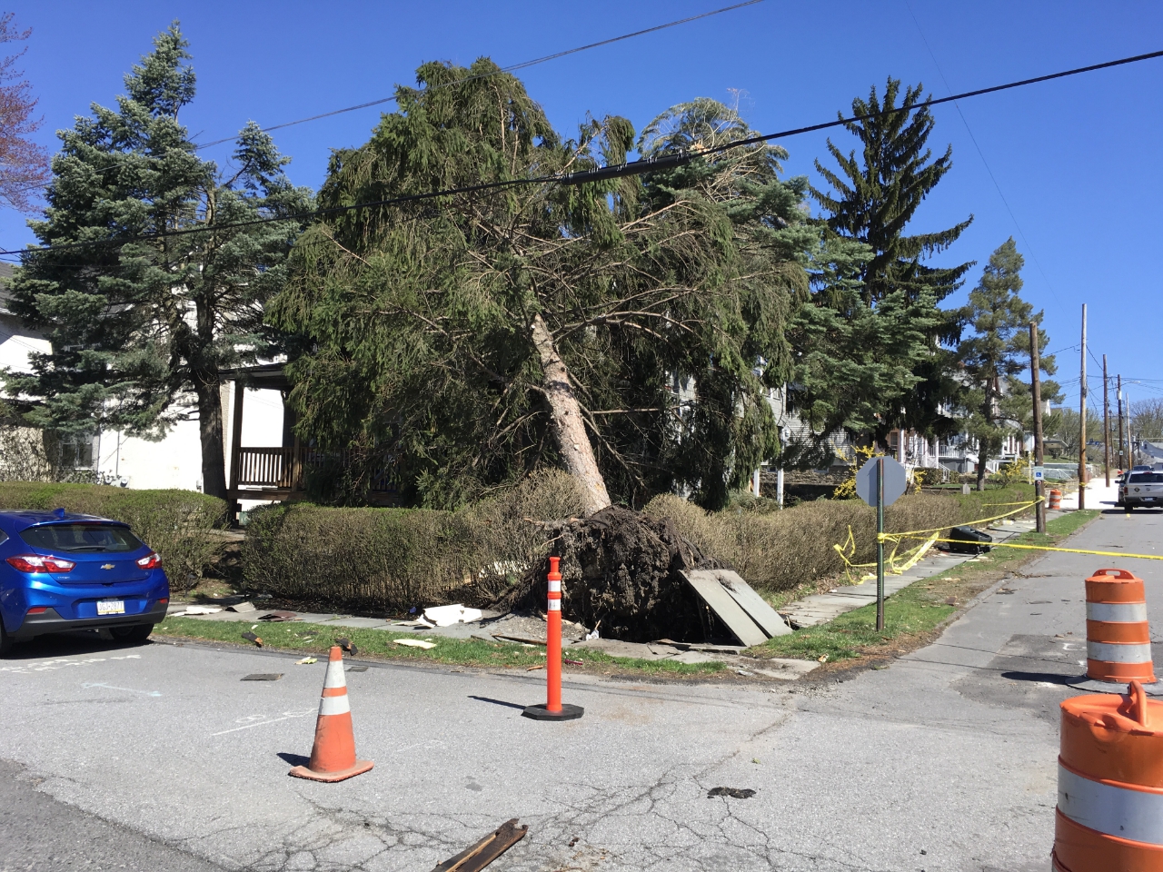
Summary
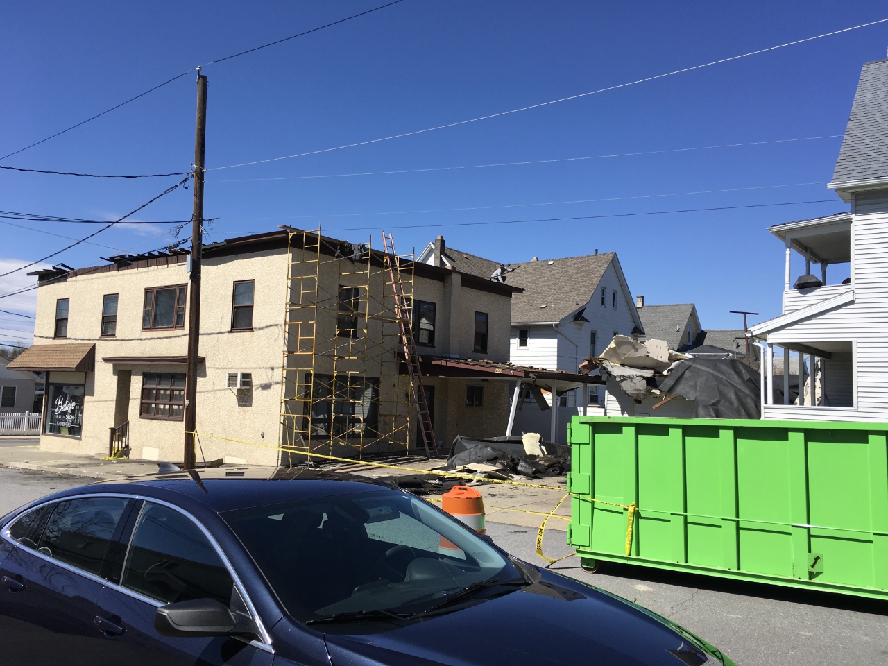
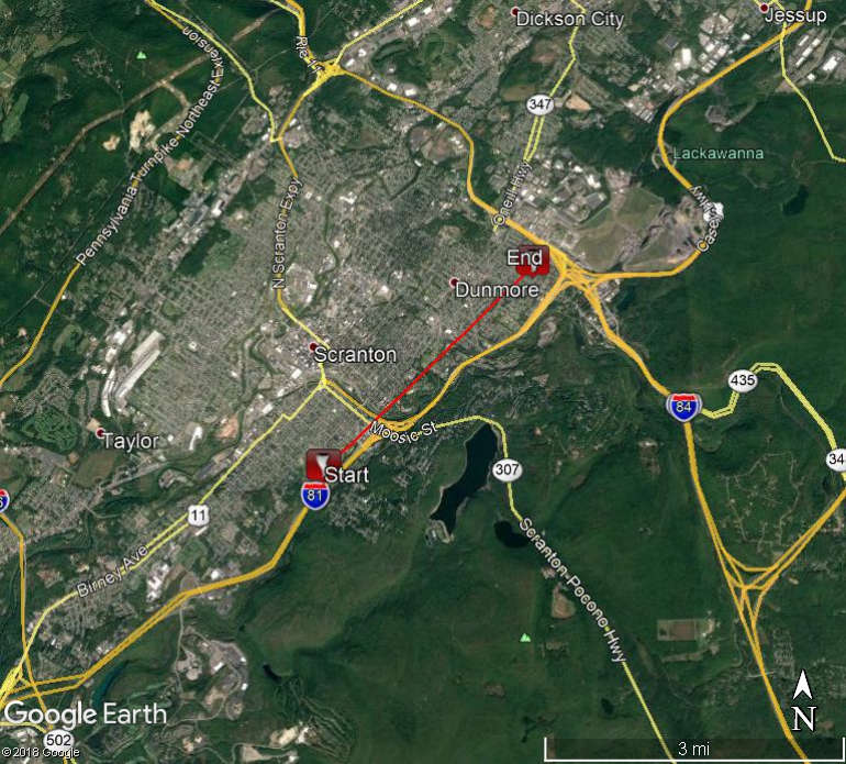 A tornado touched down at the intersection of Maple street and Boland court in Scranton taking down some trees and wires. The tornado then briefly lifted over the Central Scranton Expressway. A second touchdown occurred on Lindon street and Harrison Avenue with more tree and wire damage along with a few trees into buildings as well. Some of the residences also had roof damage. The tornado once again lifted briefly before causing more damage on 5th and cherry streets. Before finally lifting, the tornado downed several trees on a field and overturned a small structure at Sherwood park in Dunmore. Thank you to the Lackawanna county Emergency Management and local residents for the assistance with this survey. Image to right, tree on house in Scranton, PA area.
EF Scale: The Enhanced Fujita Scale classifies tornadoes into the following categories:
|
Roof damage in Scranton area. |
Tree down, pole damage. Scranton PA area. |
The information in this statement is preliminary and subject to change pending final review of the event and publication in NWS Storm Data.
DJN/MWG
 NWS Damage Survey for 04/15/19 Port Crane/Fenton/Colesville Areas Tornado Event
Summary
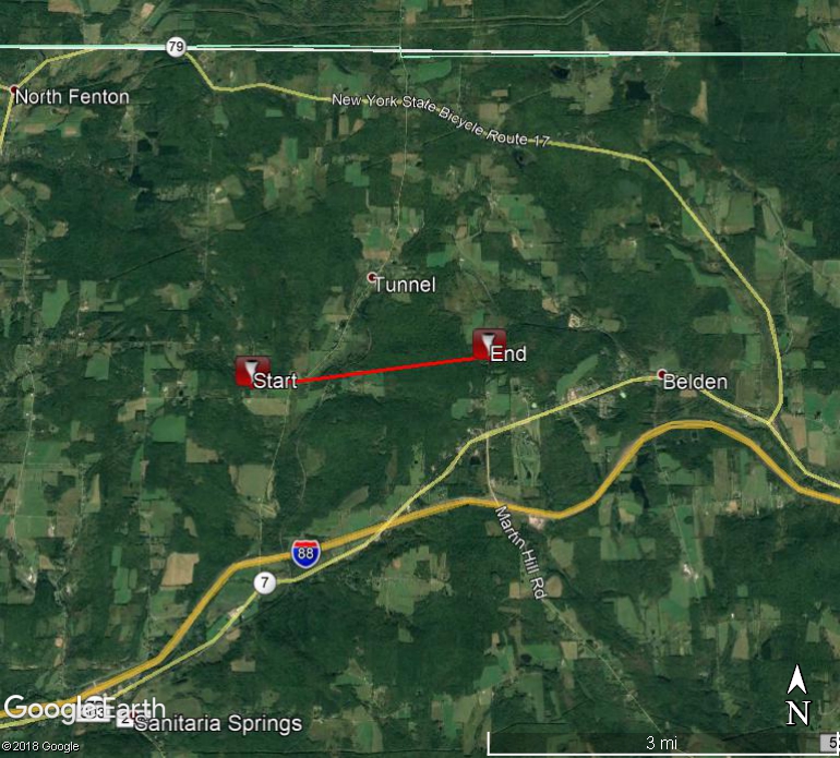
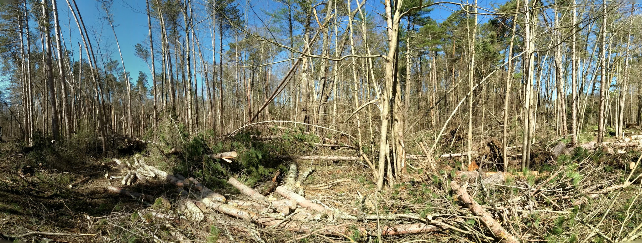
Several trees were uprooted just to the west of Monkey Run Road in Fenton which was likely close to where the tornado touched down. The most significant damage occurred as the tornado tracked eastward through two residential properties on Monkey Run Road. Several dozen softwood and hardwood trees were uprooted or snapped in its path. One house sustained moderate damage to the roof. The roof cover that was above the deck was lofted across the back yard. Insulation from the attic and a trampoline in the back yard was found 250 yards away in the middle of a densely wooded area. Damage to another house included ten broken windows, loss of shingles and a garage door that was torn off.
Farther east, several large pine trees were uprooted or snapped while roof shingles were torn off a house on Tunnel Road. Tree damage became much more sporadic farther east as the tornado lifted near Walling Road in Colesville.
The damage when the tornado was at peak intensity was consistent with an EF-1 tornado with maximum estimated winds near 100 mph.
EF Scale: The Enhanced Fujita Scale classifies tornadoes into the following categories:
The information in this statement is preliminary and subject to change pending final review of the event and publication in NWS Storm Data.
Klein/Parker
NWS Damage Survey for 04/15/19 EF1 Tornado in Susquehanna County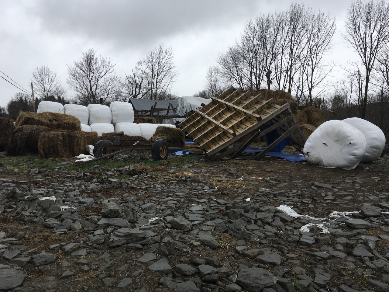
Summary
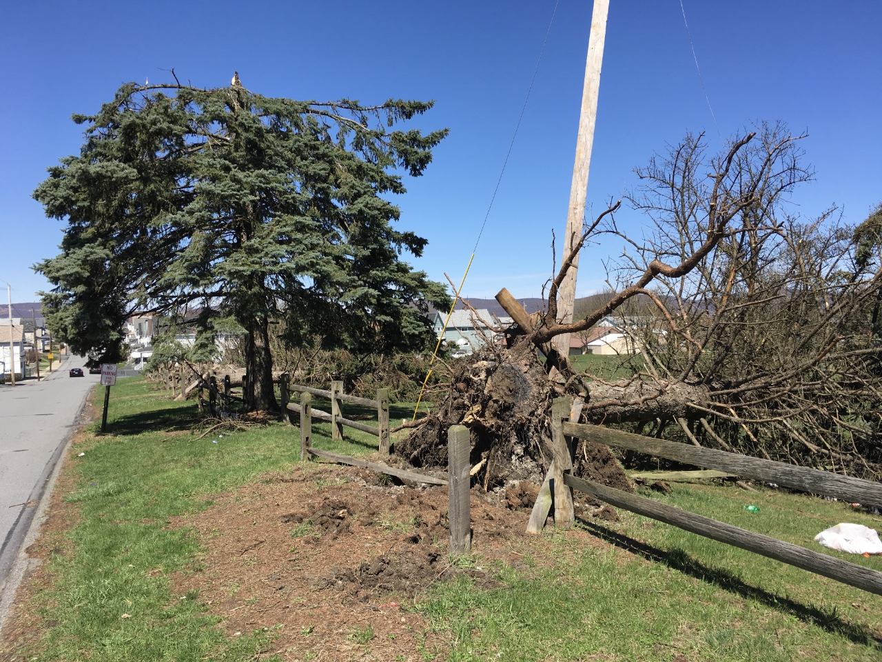
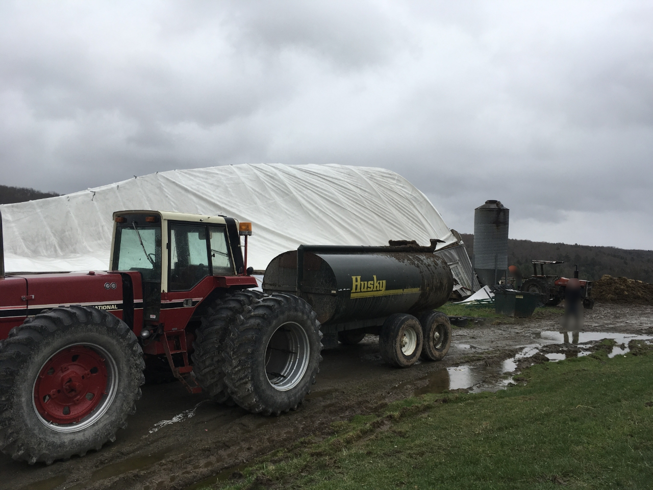
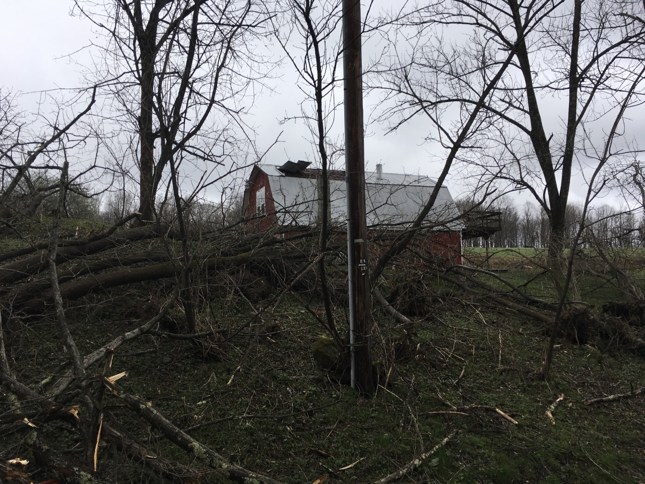
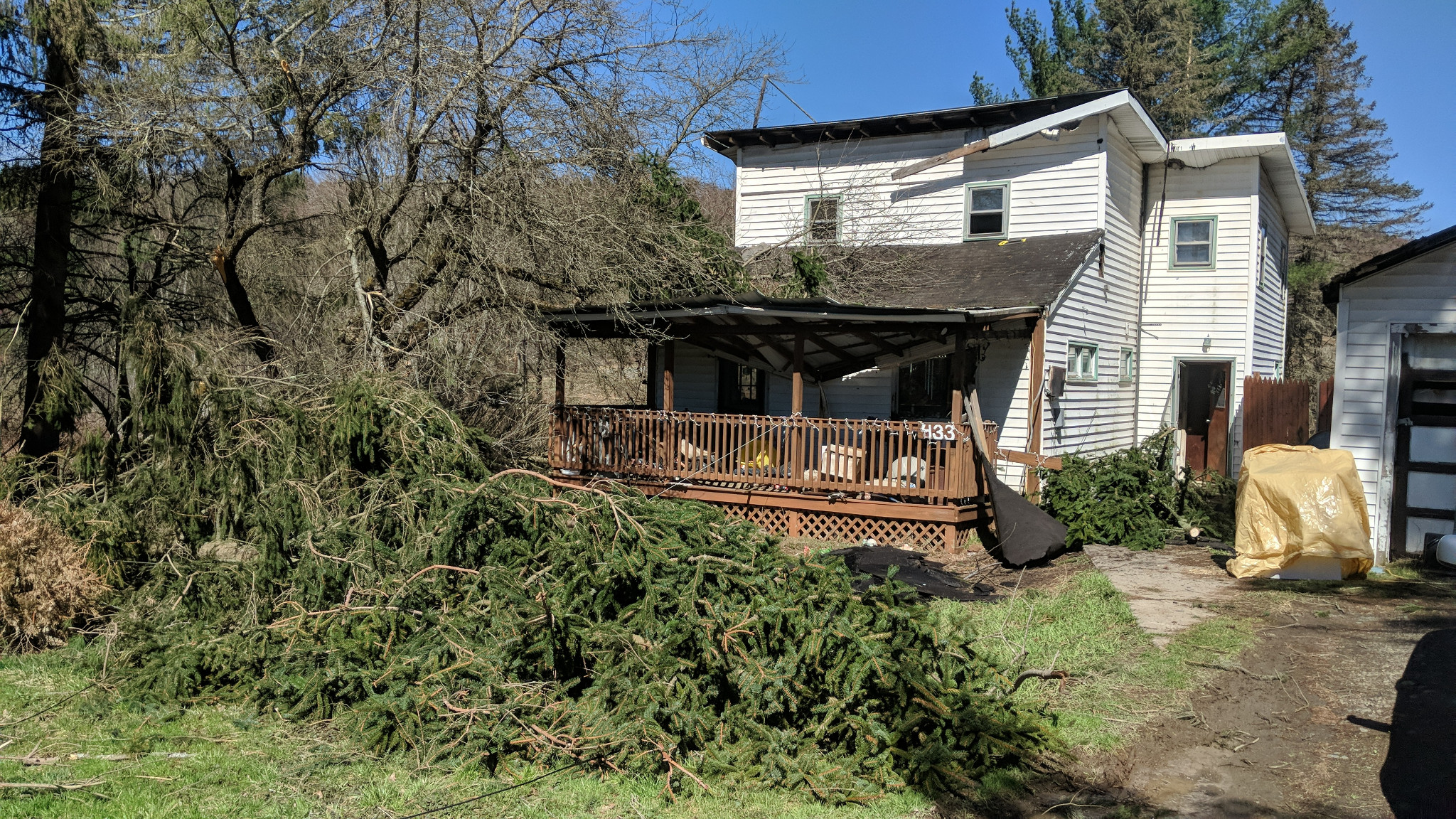
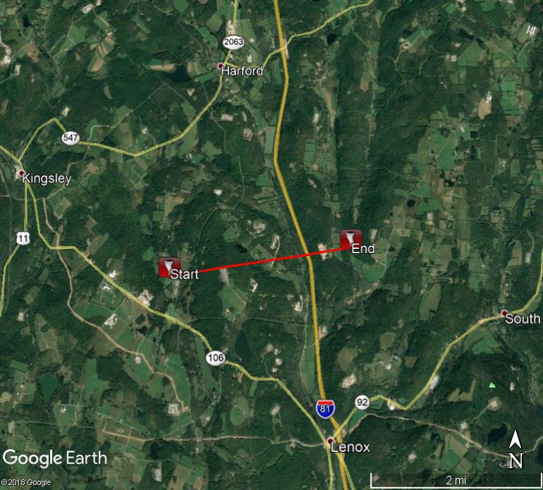 A tornado touched down on Tingly St in Harford township. The tornado moved along Deer Trail Rd and took down a barn and portions of a silo. The tornado then moved onto Orphan School Rd and Bartholomew Rd. There were trees and wires down on both roads. The tornado then lifted over I-81 and touched down again on Upper and Lower Podunk roads where more trees and wires were downed. The tornado lifted near Pennay Hill Rd. We want to thank the Susquehanna County Emergency management office, local residents, and the Thompson volunteer fire department for their assistance with this survey. Image to right: Farm damage Harford Township, PA.
EF Scale: The Enhanced Fujita Scale classifies tornadoes into the following categories:
|
Farm damage. |
Trees down and roof damage. |
The information in this statement is preliminary and subject to change pending final review of the event and publication in NWS Storm Data.
MWG/CJP/HLC
Please click on the buttons below to expand or hide the survey summary.
NWS Damage Survey for 04/15/19 Thunderstorm Wind Event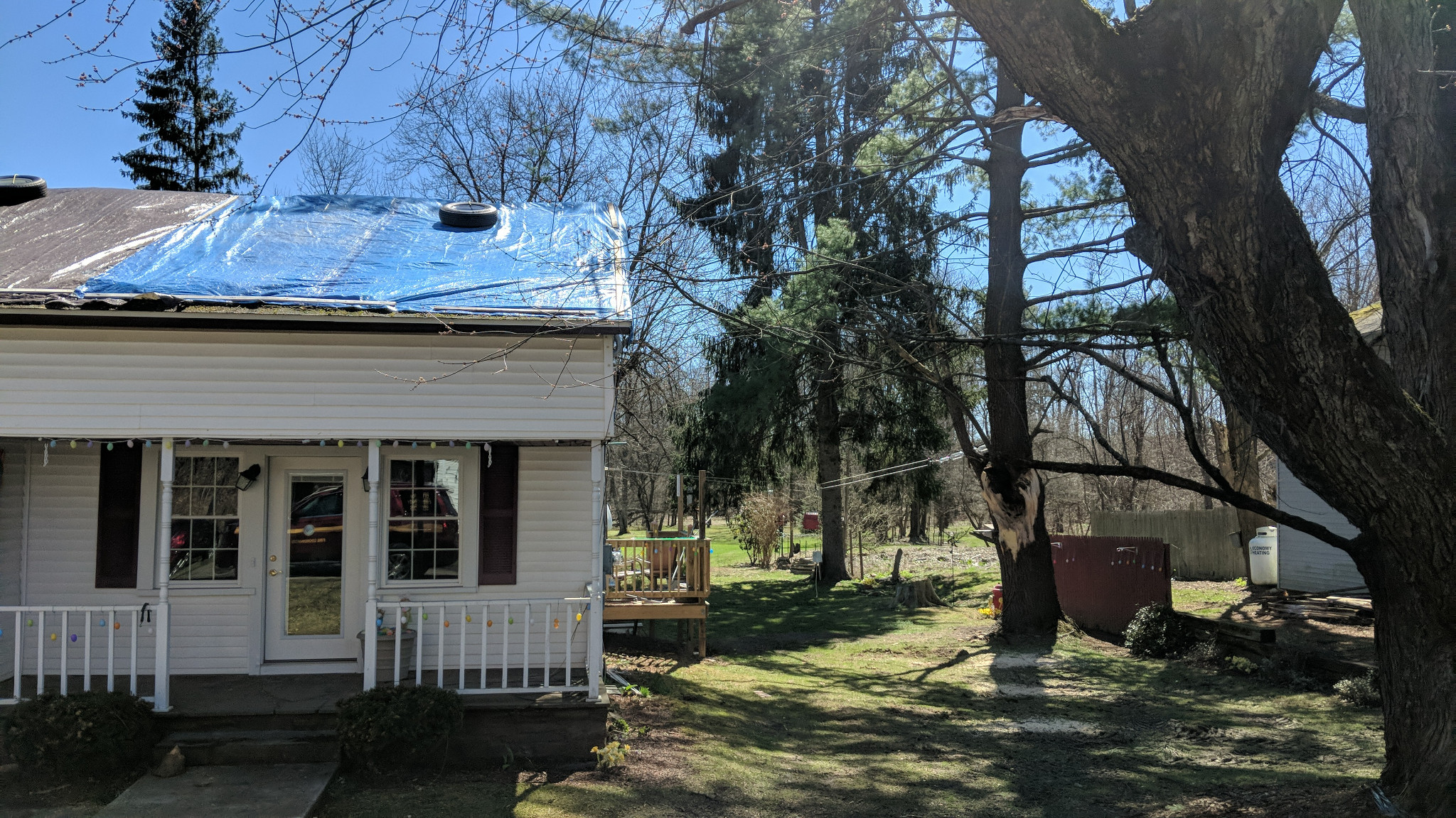
Straight-Line Microburst Winds in eastern Broome and southern Chenango Counties.
Summary
 A concentrated area of straight-line wind damage from a severe thunderstorm was first observed in Chenango Valley State Park. Dozens of pine trees were uprooted or snapped at the trunk near the main park entrance. Sporadic damage to trees continued as the storm moved eastward. A large tree fell on a house on Route 221 near Moot Town Road. Farther east, minor roof damage from strong winds occurred at a few businesses and residential houses in Harpursville. The last of the substantial damage occurred near the intersection of Route 26 and Route 40 in Afton. A large portion of a roof was blown off a house while the metal roof of a barn across the street was torn off.
Maximum wind speeds from this downburst was estimated to be near 80 mph.
The National Weather Service in Binghamton would like to thank the Office of Emergency Services from Broome and Chenango Counties who assisted our survey team.
Image: starting from top right to below, Large limb fell on house in Harpursville, NY; Trees on house near Tunnel, NY; Below swath of trees downed at Chenango Valley State Park, NY.
The information in this statement is preliminary and subject to change pending final review of the event and publication in NWS Storm Data.
JRK/RAM
NWS Damage Survey for Severe Thunderstorm Wind Event
Straight Line Microburst Winds in Conklin, New York.
Summary
Severe thunderstorms rolled through southern Broome County early this morning. A microburst with estimated winds at 70 mph blew through Conklin, NY damaging the Conklin Fire Station as a few bricks were knocked off. Numerous trees and branches were blown down in the adjacent neighborhood to the fire station.
A microburst is a localized area of strong straight line winds that descends from a thunderstorm and is less than 2.5 miles in diameter.
The National Weather Service in Binghamton would like to thank the kind volunteers from the Conklin Fire Department and residents who assisted our survey team.
The information in this statement is preliminary and subject to change pending final review of the event and publication in NWS Storm Data.
David Nicosia
Warning Coordination Meteorologist
National Weather Service Binghamton, NY
Microburst in Waymart, PA
Summary
Damage from the microburst was first detected to a property on Route 296 near North Baker Road. The roof from a large barn shifted off its frame with the west-facing exterior wall bowed out. The top to a nearby silo was blown over. Several large pine trees were snapped at the trunk in a cemetery on Owego Turnpike. Sporadic tree damage occurred farther northeast near Lake Ladore and Keen Lake. Interestingly, the most concentrated areas of tree damage occurred on the northern side of both lakes, possibly caused by winds accelerating off the water.
Maximum wind speeds from this microburst was estimated to be near 80 mph.
The information in this statement is preliminary and subject to change pending final review of the event and publication in NWS Storm Data.
Klein/Parker
Microburst in Lake Como, PA
Summary
A path of uprooted and snapped pine trees were noted along Como Road between Route 370 and Route 247. Several buildings sustained minor roof and siding damage mainly due to trees falling on them. Peak wind speeds from this microburst was estimated to be near 80 mph.
Although there was some indication within the path of downed trees of a convergent pattern that would be consistent of tornadic damage, there was not enough evidence (due to limited access for NWS officials to survey and also due to the clean up that was occurring several days after the storm) to determine it to be tornadic.
The information in this statement is preliminary and subject to change pending final review of the event and publication in NWS Storm Data.
Klein/Parker
The following are official and unofficial observations taken during The past 13 HOURS. Appreciation is extended to highway departments, cooperative observers, SKYWARN spotters and media for these reports.
********************STORM TOTAL RAINFALL********************

LOCATION          STORM TOTAL     TIME/DATE   COMMENTS
                     RAINFALL           OF
                     /INCHES/   MEASUREMENT

NEW YORK

...Sullivan County...
   Callicoon Center      2.21   617 AM  4/15  Co-Op Observer


**********************24 HOUR RAINFALL**********************

LOCATION              24 HOUR     TIME/DATE   COMMENTS
                     RAINFALL           OF
                     /INCHES/   MEASUREMENT

NEW YORK

...Broome County...
   Binghamton            1.48   825 AM  4/15  NYSM
   1 ENE Binghamton      1.25   905 AM  4/15  CoCoRaHS
   Vestal                1.24   818 AM  4/15  CWOP
   Belden                1.21   825 AM  4/15  NYSM
   3 E Vestal            1.20   600 AM  4/15  CoCoRaHS
   Windsor               1.19   816 AM  4/15  CWOP
   3 NNE Binghamton      1.12   700 AM  4/15  CoCoRaHS
   Johnson City          1.09   822 AM  4/15  CWOP
   Endicott              1.03   146 AM  4/15  CWOP
   Lisle                 0.67   822 AM  4/15  CWOP
   Whitney Point Dam     0.63   900 AM  4/15  Co-Op Observer

...Cayuga County...
   6 ENE Moravia         1.00   600 AM  4/15  CoCoRaHS
   Aurora Research Farm  0.82   700 AM  4/15  Co-Op Observer
   Scipio Center         0.78   825 AM  4/15  NYSM
   8 SSE Auburn          0.77   600 AM  4/15  CoCoRaHS
   4 NNE Cayuga          0.70   615 AM  4/15  CoCoRaHS
   2 N Aurora            0.61   815 AM  4/15  CoCoRaHS

...Chemung County...
   Elmira                1.34   825 AM  4/15  NYSM
   1 WNW Elmira          0.95   630 AM  4/15  CoCoRaHS
   1 SSE West Elmira     0.92   700 AM  4/15  CoCoRaHS
   6 N Chemung           0.77   900 AM  4/15  CoCoRaHS
   1 ESE Elmira          0.75   800 AM  4/15  CoCoRaHS
   ENE Van Etten         0.73   700 AM  4/15  CoCoRaHS
   Erin                  0.70   821 AM  4/15  CWOP
   Elmira Airport        0.67   753 AM  4/15  ASOS
   3 SSE Horseheads      0.66   700 AM  4/15  CoCoRaHS

...Chenango County...
   3 WSW Bainbridge      1.36   552 AM  4/15  CoCoRaHS
   Sherburne             1.34   820 AM  4/15  NYSM
   1 NNW Oxford          1.15   800 AM  4/15  CoCoRaHS
   Norwich               1.10   400 AM  4/15  Co-Op Observer
   Greene                0.97   950 AM  4/15  Co-Op Observer
   5 W Norwich           0.89   700 AM  4/15  CoCoRaHS
   Columbus              0.85   817 AM  4/15  CWOP
   Sherburne Fire Weath  0.63   808 AM  4/15  HADS

...Cortland County...
   1 NW Marathon         1.04   700 AM  4/15  CoCoRaHS
   Cincinnatus           0.98   825 AM  4/15  NYSM
   2 E Willet            0.81   700 AM  4/15  CoCoRaHS
   Marathon              0.77   825 AM  4/15  AWS

...Delaware County...
   Roxbury               2.03   825 AM  4/15  NYSM
   5 ESE Hobart          2.02   700 AM  4/15  CoCoRaHS
   Andes                 1.78   825 AM  4/15  NYSM
   Deposit               1.77   825 AM  4/15  NYSM
   Margaretville         1.72   815 AM  4/15  CWOP
   6 N Fleischmanns      1.69   700 AM  4/15  CoCoRaHS
   7 W Walton            1.68   700 AM  4/15  CoCoRaHS
   Walton                1.56   825 AM  4/15  NYSM
   7 WNW Delhi           1.46   700 AM  4/15  CoCoRaHS
   2 SE Delhi            1.10   800 AM  4/15  Co-Op Observer
   Norwich               1.06   815 AM  4/15  CWOP
   Harpersfield          1.05   825 AM  4/15  NYSM

...Madison County...
   2 NW Nelson           1.14   845 AM  4/15  Trained Spotter
   Morrisville           1.04   825 AM  4/15  NYSM
   6 SW Morrisville      0.90   500 AM  4/15  SNOTEL
   3 SE Cazenovia        0.87   700 AM  4/15  CoCoRaHS
   2 SW Munnsville       0.87   700 AM  4/15  CoCoRaHS
   W Earlville           0.85   700 AM  4/15  CoCoRaHS
   Brookfield            0.85   825 AM  4/15  NYSM

...Oneida County...
   Woodgate              1.21   825 AM  4/15  NYSM
   Rome                  1.15   816 AM  4/15  CWOP
   1 SE Point Rock       1.11   800 AM  4/15  CoCoRaHS
   1 WNW Holland Patent  1.11   700 AM  4/15  CoCoRaHS
   Whitesboro            1.05   823 AM  4/15  CWOP
   2 SW Whitesboro       0.94   525 AM  4/15  CoCoRaHS
   4 NNW Durhamville     0.88   700 AM  4/15  CoCoRaHS
   Westmoreland          0.86   825 AM  4/15  NYSM
   2 NW Sylvan Beach     0.84   700 AM  4/15  CoCoRaHS
   2 WSW Sauquoit        0.83   644 AM  4/15  CoCoRaHS
   5 SSE Rome            0.82   700 AM  4/15  CoCoRaHS
   Camden                0.72   825 AM  4/15  NYSM
   New Hartford          0.69   821 AM  4/15  CWOP

...Onondaga County...
   Tully                 1.03   825 AM  4/15  NYSM
   Apulia Station        1.02   820 AM  4/15  CWOP
   Onondaga              0.98   824 AM  4/15  AWS
   Skaneateles           0.82   816 AM  4/15  CWOP
   Clay                  0.80   818 AM  4/15  CWOP
   Fairmount             0.79   819 AM  4/15  CWOP
   Fayetteville          0.79   825 AM  4/15  NYSM
   2 ESE Brewerton       0.78   700 AM  4/15  CoCoRaHS
   Jordan                0.75   825 AM  4/15  NYSM
   Syracuse              0.74   816 AM  4/15  CWOP
   Phoenix               0.74   816 AM  4/15  CWOP
   Camillus              0.72   815 AM  4/15  CWOP
   Marcellus             0.71   820 AM  4/15  CWOP
   5 NW Clay             0.70   830 AM  4/15  CoCoRaHS
   1 WSW De Witt         0.68   700 AM  4/15  CoCoRaHS
   3 S Syracuse          0.68   730 AM  4/15  CoCoRaHS
   Baldwinsville         0.67   700 AM  4/15  Co-Op Observer
   Otisco                0.65   815 AM  4/15  CWOP
   1 W Camillus          0.64   700 AM  4/15  CoCoRaHS
   East Syracuse         0.62   820 AM  4/15  CWOP
   1 ENE Manlius         0.61   824 AM  4/15  AWS
   Minoa                 0.55   815 AM  4/15  CWOP
   Syracuse Airport      0.55   754 AM  4/15  ASOS

...Otsego County...
   West Winfield         1.19   820 AM  4/15  CWOP
   2 NE New Berlin       1.10   800 AM  4/15  CoCoRaHS
   Laurens               1.09   825 AM  4/15  NYSM
   Cooperstown           1.07   816 AM  4/15  CWOP
   Hartwick              0.99   700 AM  4/15  CoCoRaHS
   Oneonta               0.87   823 AM  4/15  CWOP
   Cherry Valley         0.82   823 AM  4/15  CWOP
   Springfield           0.81   825 AM  4/15  NYSM
   4 SSE Bridgewater     0.76   600 AM  4/15  CoCoRaHS

...Schuyler County...
   Burdett               1.39   825 AM  4/15  NYSM
   Bolter Creek          0.89   812 AM  4/15  RAWS
   2 SE Smith Valley     0.82   700 AM  4/15  CoCoRaHS
   Tyrone                0.77   825 AM  4/15  NYSM
   5 NW Watkins Glen     0.74   700 AM  4/15  CoCoRaHS
   6 E Dundee            0.65   700 AM  4/15  CoCoRaHS

...Seneca County...
   Waterloo              0.65   825 AM  4/15  NYSM
   Seneca Falls          0.56   821 AM  4/15  CWOP

...Steuben County...
   Hartsville            2.62   825 AM  4/15  NYSM
   Cohocton              1.48   825 AM  4/15  NYSM
   Hornell Almond Dam    1.13   800 AM  4/15  HADS
   Arkport Lake          1.13   800 AM  4/15  HADS
   1 NNW Hornell         1.02   827 AM  4/15  Trained Spotter
   Addison               0.94   500 AM  4/15  Co-Op Observer
   5 S Savona            0.83   700 AM  4/15  CoCoRaHS
   Gang Mills            0.80   808 AM  4/15  RAWS
   1 SSE Painted Post    0.77   800 AM  4/15  CoCoRaHS
   5 S South Corning     0.65   900 AM  4/15  CoCoRaHS

...Sullivan County...
   North Branch          1.77   825 AM  4/15  NYSM
   2 S Roscoe            1.20   530 AM  4/15  SNOTEL
   Sullivan County Airp  1.00   756 AM  4/15  AWOS
   Eldred                0.94   825 AM  4/15  NYSM
   Woodbourne            0.85   825 AM  4/15  NYSM
   Grahamsville          0.64   820 AM  4/15  CWOP
   Loch Sheldrake        0.54   824 AM  4/15  AWS

...Tioga County...
   3 ESE Apalachin       1.21   900 AM  4/15  CoCoRaHS
   Owego                 1.16   825 AM  4/15  NYSM
   Apalachin             1.11   823 AM  4/15  CWOP
   2 ENE Berkshire       1.10   800 AM  4/15  CoCoRaHS
   1 NW Candor           0.82   710 AM  4/15  CoCoRaHS

...Tompkins County...
   3 ENE Ithaca          1.16   700 AM  4/15  Co-Op Observer
   Groton                1.14   825 AM  4/15  NYSM
   5 E East Ithaca       1.11   700 AM  4/15  CoCoRaHS
   Slaterville Springs   1.06   816 AM  4/15  CWOP
   6 E Ithaca            1.04   730 AM  4/15  CoCoRaHS
   3 S Newfield          0.99   700 AM  4/15  CoCoRaHS
   2 NE Freeville        0.97   700 AM  4/15  CoCoRaHS
   Dryden                0.97   819 AM  4/15  CWOP
   4 W Freeville         0.96   700 AM  4/15  CoCoRaHS
   West Danby            0.92   821 AM  4/15  CWOP
   3 NW Ithaca           0.92   800 AM  4/15  CoCoRaHS
   3 SSW Groton          0.81   615 AM  4/15  CoCoRaHS
   1 NE Freeville        0.81   800 AM  4/15  Co-Op Observer
   1 NW Groton           0.79   700 AM  4/15  CoCoRaHS
   Ithaca                0.73   757 AM  4/15  CWOP

...Yates County...
   4 S Middlesex         0.79   900 AM  4/15  CoCoRaHS
   Penn Yan              0.62   825 AM  4/15  NYSM
   Lakemont              0.58   825 AM  4/15  CWOP

PENNSYLVANIA

...Bradford County...
   1 S Towanda           1.26   700 AM  4/15  Co-Op Observer
   Roaring Creek         1.16   756 AM  4/15  RAWS
   1 S Sayre             1.01   700 AM  4/15  CoCoRaHS
   3 WNW Sayre           0.85   700 AM  4/15  CoCoRaHS
   1 NW Cherrytown       0.70   116 AM  4/15  AWS
   Ridgebury             0.54   816 AM  4/15  CWOP

...Columbia County...
   East Berwick          0.85   824 AM  4/15  AWS

...Lackawanna County...
   Sterling - 22         2.54   700 AM  4/15  CoCoRaHS
   Thornhurst            2.53   728 AM  4/15  RAWS
   2 SW Archbald         1.52   745 AM  4/15  CoCoRaHS
   Archbald              1.43   825 AM  4/15  CWOP
   Jermyn                1.37   821 AM  4/15  CWOP
   Richmondale           0.78   825 AM  4/15  CWOP

...Luzerne County...
   2 NW Hazleton         2.62   759 AM  4/15  CoCoRaHS
   Hazleton              2.31   800 AM  4/15  CWOP
   Bear Creek Township   2.29   814 AM  4/15  CWOP
   4 NE Conyngham        2.13   700 AM  4/15  CoCoRaHS
   Francis E Walter Dam  2.01   915 AM  4/15  Co-Op Observer
   Exeter                1.80   815 AM  4/15  Trained Spotter
   Nescopeck Pass        1.67   815 AM  4/15  CWOP
   Drums                 1.40   821 AM  4/15  CWOP
   Hanover Township      1.30   822 AM  4/15  CWOP
   Glen Summit           1.26   825 AM  4/15  AWS
   West Pittston         1.10   825 AM  4/15  AWS
   Wilkes-Barre          1.05   825 AM  4/15  AWS
   Dallas                0.77   824 AM  4/15  AWS
   1 E Miners Mills      0.76   825 AM  4/15  AWS
   Plains                0.58   137 AM  4/15  AWS
   Miners Mills          0.57   824 AM  4/15  AWS

...Pike County...
   2 NNW Dingmans Ferry  0.63   824 AM  4/15  AWS
   9 NW Milford          0.57   700 AM  4/15  CoCoRaHS
   Milford               0.54   824 AM  4/15  AWS

...Susquehanna County...
   SE Stanfordville      1.27   430 AM  4/15  CoCoRaHS
   1 NNE Harford         1.27   745 AM  4/15  CoCoRaHS
   2 SSE New Milford     1.01   720 AM  4/15  CoCoRaHS
   Hop Bottom            0.82   815 AM  4/15  CWOP
   Stillwater Dam        0.73   900 AM  4/15  Co-Op Observer

...Wayne County...
   Lake Ariel            3.03   825 AM  4/15  CWOP
   Milanville            2.98   830 AM  4/15  Co-Op Observer
   CHERRY RIDGE 13A      2.56   700 AM  4/15  CoCoRaHS
   Lackawaxen River      2.06   730 AM  4/15  HADS
   PROMPTON - 25         1.83   700 AM  4/15  CoCoRaHS
   Dyberry Creek         1.78   730 AM  4/15  HADS
   1 W Arlington         1.75   824 AM  4/15  AWS
   OREGON - 23           1.75   600 AM  4/15  CoCoRaHS
   West Branch Lackawax  1.67   730 AM  4/15  HADS
   Dyberry - 19          1.65   648 AM  4/15  CoCoRaHS
   Gouldsboro            1.62   815 AM  4/15  CWOP
   Seelyville            1.30   825 AM  4/15  AWS
   Starrucca - 27        1.10   700 AM  4/15  CoCoRaHS
   Hawley - 15           0.77   700 AM  4/15  CoCoRaHS
   1 W Pleasant Mount    0.75   700 AM  4/15  Co-Op Observer
   Hawley                0.68   815 AM  4/15  CWOP

...Wyoming County...
   4 NW Tunkhannock      0.72   955 AM  4/15  CoCoRaHS
   Tunkhannock Creek     0.71   815 AM  4/15  HADS
...HIGHEST WIND REPORTS IN THE PAST 12 HOURS...

Location                     Speed     Time/Date       Provider

...New York...

...Broome County...
Binghamton                   60 MPH    0120 AM 04/15   NYSM
Belden                       48 MPH    0145 AM 04/15   NYSM
Binghamton Airport           43 MPH    0114 AM 04/15   ASOS

...Cayuga County...
Scipio Center                50 MPH    1145 PM 04/14   NYSM

...Chenango County...
Sherburne                    46 MPH    0130 AM 04/15   NYSM

...Delaware County...
Roxbury                      51 MPH    0300 AM 04/15   NYSM
Andes                        44 MPH    0240 AM 04/15   NYSM
Deposit                      40 MPH    0205 AM 04/15   NYSM

...Oneida County...
Griffiss Airfield            47 MPH    0101 AM 04/15   AWOS

...Onondaga County...
Apulia Station               41 MPH    1130 PM 04/14   CWOP

...Otsego County...
Laurens                      43 MPH    0210 AM 04/15   NYSM

...Steuben County...
Hartsville                   53 MPH    1030 PM 04/14   NYSM
Cohocton                     50 MPH    1045 PM 04/14   NYSM

...Sullivan County...
Sullivan County Airport      44 MPH    1205 AM 04/15   AWOS

...Tioga County...
Berkshire                    42 MPH    0100 AM 04/15   NYSM
Owego                        42 MPH    0100 AM 04/15   NYSM

...Yates County...
Penn Yan                     45 MPH    1115 PM 04/14   NYSM
Penn Yan                     41 MPH    1112 PM 04/14   ASOS

...Pennsylvania...

...Luzerne County...
Hanover Township             56 MPH    0144 AM 04/15   CWOP
Wilkes-Barre/Scranton Airpor 53 MPH    0149 AM 04/15   ASOS
For reference: