NWS Damage Survey Finds Tornado For Nescopeck Township, PA

Survey Summary:
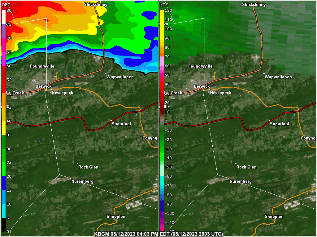
A tornado touched down just north of Interstate 80 along Nescopeck Creek. A narrow alley of numerous downed or snapped trees occurred, roughly following Overlook Road and then West Hollow Road, where a convergent and at times oppositional tree pattern was observed. The tornado departed West Hollow Road only to reemerge crossing Route 93, where a few hundred small apple trees were pushed over in an orchard, and a front porch roof was lifted up and over a house, while peeling back a portion of the primary roof of the residence. A large tree top was also lofted, and thrown to Zenith Road, to the left of the tornado path. The tornado intensified while moving along Hobbie Road, with numerous large trunk snaps, including several trees damaging a residence with a destroyed shed. The yard had several missiles in the form of small branches impaling into the ground. The tornado finally lifted shortly after, before reaching the intersection of Hobbie Road and Wapwallopen Road.
NOTE: The information in this statement is preliminary and subject to change pending final review of the event and publication in NWS Storm Events Database.
Below shows a two panel display showing NWS WSR-88D at Binghamton, NY radar base reflectivity on the left and storm relative motion (velocity) on the right. The loop is from 04:05 PM EDT (2005 UTC) to 05:03 PM EDT (2103 UTC) on August 12, 2023. Click on the image for a larger view.
NWS Damage Survey for 08/12/23 Microburst Event in Athens and Sayre PA

Survey Summary:
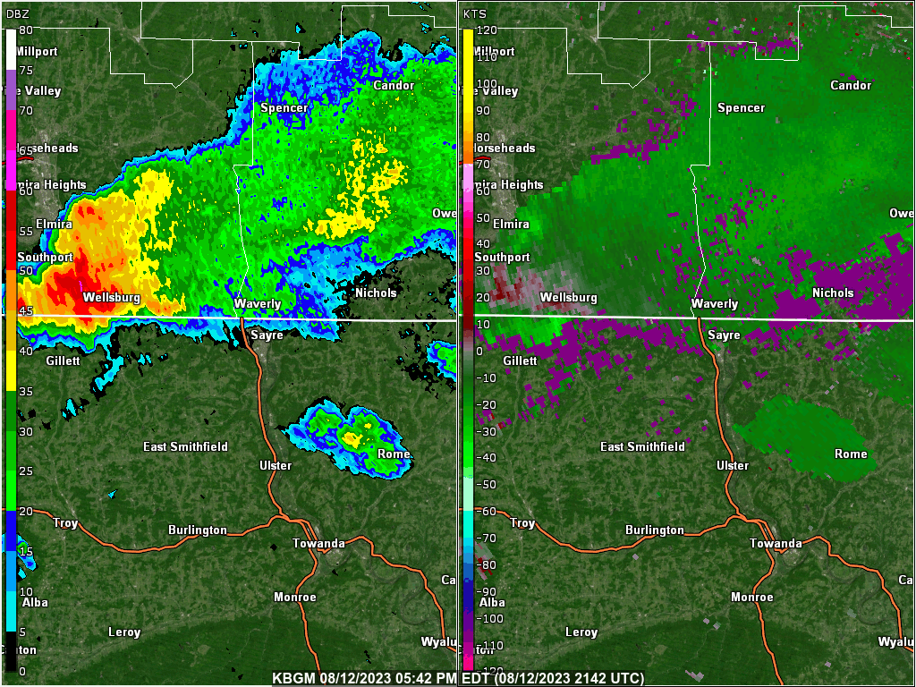
A microburst with maximum winds up to 90 mph hit Athens Township near the NY border by the old Blue Swan Airport. The strong winds knocked down many branches along its path which was to the east southeast through parts of Sayre Borough and Athens Borough. The strongest damage was on Markham Road where large softwood trees were uprooted. Many other areas along the microburst path saw sporadic trees snapped and uprooted with many branches down. The majority of these trees were softwoods. An outer roof was lifted off of a modular home in Athens. Power was out to many locations. The pattern of the damage is consistent with a microburst as the damage was in a divergent or spreading out pattern.
NOTE: The information in this statement is preliminary and subject to change pending final review of the event and publication in NWS Storm Events Database.
Below shows a two panel display showing NWS WSR-88D at Binghamton, NY radar base reflectivity on the left and storm relative motion (velocity) on the right. The loop is from 05:42 PM EDT (2142 UTC) to 06:23 PM EDT (2223 UTC) on August 12, 2023. Click on the image for a larger view.
NWS Damage Survey Finds Tornado near Fishs Eddy, NY

Survey Summary:
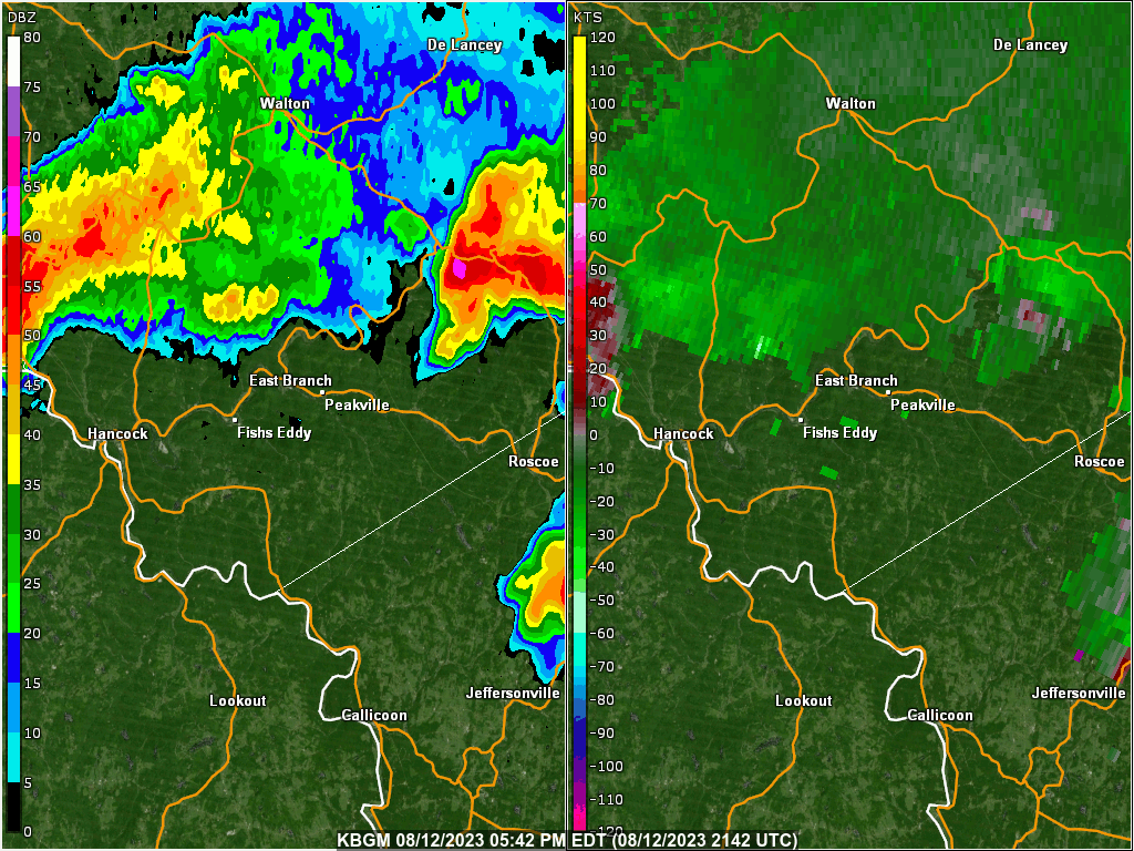
A tornado briefly touched down along the south shore of the East Branch Delaware River near Fishs Eddy causing damage to trees. An eyewitness reported seeing his 75-100 foot hemlock tree twist and snap off about halfway up the trunk. Another eyewitness captured video of a rotating wall cloud in the general vicinity of this area of damage. The tornado crossed O&W Road, proceeding uphill causing further damage to some trees in the forest and power lines along Hubbell Hill Road. Due to extremely steep terrain, the evidence of further tornado damage was unobtainable through these wooded areas. Additional tree damage was observed at the intersection of O&W Road and Halls Island Road to the southeast of East Branch. The tornado is believed to have skipped through the mountainous area before lifting over the Beaver Kill. No further damage was noted or reported across the river toward Baxter Mountain.
We want to thank the local emergency manager and the residents of the Town of Hancock for assistance with this survey.
NOTE: The information in this statement is preliminary and subject to change pending final review of the event and publication in NWS Storm Events Database.
Below shows a two panel display showing NWS WSR-88D at Binghamton, NY radar base reflectivity on the left and storm relative motion (velocity) on the right. The loop is from 05:42 PM EDT (2142 UTC) to 06:37 PM EDT (2237 UTC) on August 12, 2023. Click on the image for a larger view.
Addition Information

