Binghamton, NY
Weather Forecast Office
Microburst /Straight Line Wind Damage/ Confirmed Near Marietta in Onondaga County New York

The information in this statement is preliminary and subject to change pending final review of the event(s) and publication in NWS Storm Data.
Summary
The National Weather Service in Binghamton NY has confirmed a Microburst /Straight Line Wind Damage/ near Marietta in Onondaga County New York on 08/13/2016.
A severe thunderstorm producing winds of 65 to 70 mph struck about three miles south of Marietta, NY, near Willow Hill Road and Willowdale Road. Sporadic tree damage occurred, including snapped tree limbs and trees uprooted along a creek bed.
Storm Reports
A map with storm reports.
For reference
A microburst is a convective downdraft with an affected outflow area of less than 2 1/2 miles wide and peak winds lasting less than 5 minutes. Microbursts may induce dangerous horizontal and vertical wind shears, which can adversely affect aircraft performance and cause property damage. Straight-line winds are generally any wind that is not associated with rotation, used mainly to differentiate them from tornadic winds.
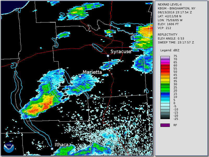
Below is a radar loop from 7:17 PM to 8:56 PM EDT. Note the large storm that moves across Marietta and just south.
Current Hazards
Briefing
Drought
Fire Weather
Graphical Hazardous Weather Outlook
Hurricanes
Local Outlook
River Flooding
Space Weather
Thunderstorms
Winter
Current Conditions
Air Quality
Local Storm Reports
Observation (list)
Observations (Map)
More Surface Observations
Rainfall
Satellite
More Satellite
Upper Air
Radar
Local Enhanced Radar
Local Standard Radar (low bandwidth)
Regional/National Standard Radar (low bandwidth)
More Radar
Forecasts
Activity Planner
Aviation
Fire Weather
Forecaster's Discussion
HeatRisk
Hourly View
Map View
Model Data
NWS GIS Viewer
Space Weather
Text Products
Rivers and Lakes
River Observation/Forecasts (Map)
River Forecast Centers
County Flash Flood Guidance
Current Streamflow
Ensemble River Guidance
Flood Inundation Maps
US Dept of Commerce
National Oceanic and Atmospheric Administration
National Weather Service
Binghamton, NY
32 Dawes Drive
Johnson City, NY 13790
(607) 729-1597
Comments? Questions? Please Contact Us.

