A storm system moved up the Unitied States east coast from Tuesday December 9 through Thursday December 11, 2014. The storm system, also known as a Nor'easter, produced varying snowfall amounts with a highest amounts across parts of central New York.
Nor'easter: A strong low pressure system that affects the Mid Atlantic and New England States. It can form over land or over the coastal waters. These winter weather events are notorious for producing heavy snow, rain, and tremendous waves that crash onto Atlantic beaches, often causing beach erosion and structural damage. Wind gusts associated with these storms can exceed hurricane force in intensity. A nor'easter gets its name from the continuously strong northeasterly winds blowing in from the ocean ahead of the storm and over the coastal areas.
Appreciation is extended to cooperative observers SKYWARN spotters, those following us on Facebook and Twitter, highway departments, public and the media for these reports.
NOUS41 KBGM 111748
PNSBGM
NYZ009-015>018-022>025-036-037-044>046-055>057-062-PAZ038>040-043-
044-047-048-072-120548-

PUBLIC INFORMATION STATEMENT
SPOTTER REPORTS
NATIONAL WEATHER SERVICE BINGHAMTON NY
1248 PM EST THU DEC 11 2014

THE FOLLOWING ARE OFFICIAL AND UNOFFICIAL OBSERVATIONS TAKEN DURING
THE PAST 13 HOURS. APPRECIATION IS EXTENDED TO HIGHWAY DEPARTMENTS...
COOPERATIVE OBSERVERS...SKYWARN SPOTTERS AND MEDIA FOR THESE REPORTS.
THIS SUMMARY IS ALSO AVAILABLE ON OUR HOME PAGE AT WEATHER.GOV/BGM.

********************STORM TOTAL SNOWFALL********************

LOCATION          STORM TOTAL     TIME/DATE   COMMENTS
                     SNOWFALL           OF
                     /INCHES/   MEASUREMENT

NEW YORK

...BROOME COUNTY...
   NWS BINGHAMTON         9.5   700 AM 12/11  48 HRS.
   3 NE WINDSOR           9.0  1113 AM 12/11  48 HRS
   TRIANGLE               9.0   509 AM 12/11  FACEBOOK
   BROOKVALE              8.6   717 AM 12/11  TRAINED SPOTTER
   1 NW PARK TERRACE      7.5  1021 AM 12/11  48 HRS.
   5 SSE BINGHAMTON       7.5  1024 AM 12/11  48 HRS
   VESTAL                 7.5   851 AM 12/11  48 HRS.
   3 E VESTAL             7.0  1025 AM 12/11  48 HRS.
   1 SE MEADOWBROOKE ES   6.8  1022 AM 12/11  48 HRS.
   JOHNSON CITY           6.7   756 AM 12/11  48 HRS.
   BINGHAMTON             6.5   839 AM 12/11  48 HRS.
   CHENANGO BRIDGE        6.0   900 AM 12/11  FACEBOOK
   1 ENE BINGHAMTON       5.4  1023 AM 12/11  48 HRS.
   ENDWELL                5.1   705 AM 12/11  FACEBOOK
   WHITNEY POINT DAM      5.0   700 AM 12/11  CO-OP OBSERVER
   ROSS CORNERS           4.2   800 AM 12/11  BROADCAST MEDIA

...CAYUGA COUNTY...
   SEMPRONIUS            18.0   600 AM 12/11  FACEBOOK
   AUBURN                13.2   600 AM 12/11  CO-OP OBSERVER
   CATO                  12.0   730 AM 12/11  TRAINED SPOTTER
   AURORA RESEARCH FARM  10.0   700 AM 12/11  CO-OP OBSERVER
   CAYUGA LOCK NO 1       8.0   730 AM 12/11  CO-OP OBSERVER

...CHEMUNG COUNTY...
   BIG FLATS              6.1   800 AM 12/11  ELEVATION 900 FEET
   VAN ETTEN              4.8   920 AM 12/11  48 HRS.
   3 WNW SAYRE            3.7  1117 AM 12/11  48 HRS.
   CHEMUNG                3.0   700 AM 12/11  CO-OP OBSERVER
   ELMIRA                 3.0   148 AM 12/11  FACEBOOK
   HORSEHEADS             3.0   512 AM 12/11  FACEBOOK
   1 W ORCHARD KNOLL      2.1   919 AM 12/11  48 HRS.
   1 WNW ELMIRA           2.0   918 AM 12/11  48 HRS.

...CHENANGO COUNTY...
   LINCKLAEN             23.5   538 AM 12/11  FACEBOOK
   4 NW SHERBURNE        12.8   800 AM 12/11  BROADCAST MEDIA
   3 N HARRISVILLE       12.8   921 AM 12/11  48 HRS.
   2 W PRESTON            6.6   922 AM 12/11  48 HRS.
   SHERBURNE              5.0   730 AM 12/11  CO-OP OBSERVER
   NORWICH                4.0   700 AM 12/11  CO-OP OBSERVER
   BAINBRIDGE             3.0   511 AM 12/11  FACEBOOK

...CORTLAND COUNTY...
   CORTLAND              20.0   147 AM 12/11  FACEBOOK
   1 ENE CORTLAND        18.2   924 AM 12/11  TRAINED SPOTTER
   MARATHON              12.3   719 AM 12/11  48 HR TOTAL.
   1 E WILLET            10.2   816 AM 12/11  48 HRS.
   1 NNE FREETOWN CORNE   9.0   927 AM 12/11  48 HRS.
   HARFORD                8.5   424 AM 12/11  FACEBOOK

...DELAWARE COUNTY...
   TROUT CREEK           13.5   730 AM 12/11  BROADCAST MEDIA
   2 ENE HOBART          12.5   932 AM 12/11  48 HRS.
   6 W WALTON             5.2   931 AM 12/11  48 HRS.
   WALTON                 3.8   515 AM 12/11  CO-OP OBSERVER
   EAST SIDNEY            2.0   700 AM 12/11  CO-OP OBSERVER

...MADISON COUNTY...
   1 S CAZENOVIA         22.5   910 AM 12/11  TRAINED SPOTTER
   2 SW MUNNSVILLE       20.0   938 AM 12/11  48 HRS.
   ONEIDA                19.5   405 AM 12/11  FACEBOOK
   2 SE CAZENOVIA        18.6   935 AM 12/11  48 HRS.
   2 ESE CHITTENANGO     13.9   937 AM 12/11  48 HRS.
   CHITTENANGO           11.5   555 AM 12/11  TRAINED SPOTTER
   EARLVILLE              9.5   938 AM 12/11  48 HRS.
   CANASTOTA              8.8   537 AM 12/11  FACEBOOK
   MORRISVILLE            8.4   700 AM 12/11  CO-OP OBSERVER

...ONEIDA COUNTY...
   1 WNW HOLLAND PATENT   9.3   947 AM 12/11  48 HRS.
   VERNON                 7.4   945 AM 12/11  48 HRS.
   3 SSW WOODGATE         7.2   942 AM 12/11  48 HRS.
   1 S UTICA              7.0   650 AM 12/11  FACEBOOK
   HOLLAND PATENT         7.0   800 AM 12/11  48 HRS.
   WHITESBORO             7.0   930 AM 12/11  FACEBOOK
   1 N UTICA              6.8   645 AM 12/11  VIA WKTV.
   ROME                   6.7   605 AM 12/11  FACEBOOK
   1 WNW DUMBARTON        6.6   948 AM 12/11  48 HRS.
   VERONA                 6.5   800 AM 12/11  FACEBOOK
   1 SE POINT ROCK        6.2   943 AM 12/11  48 HRS.
   4 N WESTMORLAND COOP   5.6   700 AM 12/11  CO-OP OBSERVER
   DIX                    5.6   945 AM 12/11  48 HRS.
   1 WNW DELTA LAKE TRA   5.5   943 AM 12/11  48 HRS.
   DELTA LAKE             5.5   845 AM 12/11  48 HRS.
   CLINTON                5.3   743 AM 12/11  TRAINED SPOTTER
   2 SSW BOONVILLE        5.1   700 AM 12/11  CO-OP OBSERVER

...ONONDAGA COUNTY...
   JAMESVILLE            27.5   900 AM 12/11  8 INCHES FELL OVERNIGHT
   1 E TULLY             26.2   952 AM 12/11  48 HRS.
   MANLIUS               23.5   715 AM 12/11  TRAINED SPOTTER
   1 WSW DE WITT         19.9   949 AM 12/11  48 HRS.
   HOWLETT HILL          17.0  1047 AM 12/11  48 HRS.
   EAST SYRACUSE         16.6  1030 AM 12/11  FACEBOOK
   CAMILLUS              16.5   543 AM 12/11  TRAINED SPOTTER
   SOLVAY                16.5   855 AM 12/11  48 HRS.
   1 W CAMILLUS          16.5   950 AM 12/11  48 HRS.
   EASTWOOD              15.8   900 AM 12/11  FACEBOOK
   DEWITT                15.0   740 AM 12/11  48 HR TOTAL.
   DE WITT               15.0  1112 AM 12/11  48 HRS
   1 E THREE RIVERS      14.8   951 AM 12/11  48 HRS.
   FAIRMOUNT             14.7  1158 AM 12/11  TWITTER
   4 NE BALDWINSVILLE    14.3   953 AM 12/11  48 HRS.
   LIVERPOOL             14.0   645 AM 12/11  TRAINED SPOTTER
   1 ENE STILES          13.4   950 AM 12/11  48 HRS.
   SYRACUSE              12.0   625 AM 12/11  UNIVERSITY HILL
   BAYBERRY              11.7   730 AM 12/11  TRAINED SPOTTER
   BALDWINSVILLE         11.5   642 AM 12/11  ELEVATION 382 FEET
   CICERO                11.2   706 AM 12/11  47 HR TOTAL.

...OTSEGO COUNTY...
   UNADILLA              10.0   629 AM 12/11  TRAINED SPOTTER
   EAST WORCESTER         7.5   958 AM 12/11  48 HRS.
   2 SW EMMONS            7.1   721 AM 12/11  CO-OP OBSERVER
   RICHFIELD SPRINGS      7.0   958 AM 12/11  48 HRS.
   HARTWICK               7.0   559 AM 12/11  48 HR TOTAL
   FLY CREEK              6.5   728 AM 12/11  48 HR TOTAL.
   1 S LLOYDSVILLE        6.5   957 AM 12/11  48 HRS.
   COOPERSTOWN            5.5  1200 AM 12/11  CO-OP OBSERVER
   MORRIS                 5.0   510 AM 12/11  FACEBOOK
   ONEONTA                3.6   700 AM 12/11  CO-OP OBSERVER
   2 N UNADILLA           3.3   700 AM 12/11  CO-OP OBSERVER

...SCHUYLER COUNTY...
   4 SW MECKLENBURG      11.0   900 AM 12/11  FACEBOOK
   1 W CAYUTAVILLE        9.2  1000 AM 12/11  48 HRS.
   1 SE VALOIS            7.0  1001 AM 12/11  48 HRS.
   1 SSW READING CENTER   4.5  1001 AM 12/11  48 HRS.

...SENECA COUNTY...
   SENECA FALLS          14.0   523 AM 12/11  FACEBOOK
   OVID                   8.7   423 AM 12/11  FACEBOOK

...STEUBEN COUNTY...
   4 SSE COHOCTON         6.0  1005 AM 12/11  48 HRS.
   1 E AVOCA              5.8   835 AM 12/11  48 HRS.
   1 WNW CATON            5.3  1003 AM 12/11  48 HRS.
   ADDISON                5.2   700 AM 12/11  CO-OP OBSERVER
   JASPER                 5.0   615 AM 12/11  FACEBOOK
   HORNELL ALMOND DAM     5.0   700 AM 12/11  CO-OP OBSERVER
   1 NNW HORNELL          4.5   818 AM 12/11  48 HRS.
   SAVONA                 3.5   640 AM 12/11  FACEBOOK
   4 E BATH               3.0  1004 AM 12/11  48 HRS.

...SULLIVAN COUNTY...
   LONG EDDY              4.7   928 AM 12/11  48 HRS.
   2 ESE LIVINGSTON MAN   2.4  1006 AM 12/11  48 HRS.

...TIOGA COUNTY...
   1 SSE RICHFORD         9.5  1009 AM 12/11  48 HRS.
   WILLSEYVILLE           9.0   745 AM 12/11  TRAINED SPOTTER
   2 NW BERKSHIRE         8.0  1010 AM 12/11  48 HRS.
   CANDOR                 7.3   800 AM 12/11  FACEBOOK
   2 N FOSTER             6.2   530 AM 12/11  NWS EMPLOYEE
   2 SE APALACHIN         5.8   601 AM 12/11  NWS EMPLOYEE
   TIOGA TERRACE          5.7   542 AM 12/11  48 HR. TOTAL
   3 WSW OWEGO            5.5   700 AM 12/11  CO-OP OBSERVER
   APALACHIN              5.4   545 AM 12/11  FACEBOOK
   WAVERLY                5.2  1130 AM 12/11  TRAINED SPOTTER
   OWEGO                  5.1   630 AM 12/11  ELEVATION 820 FEET

...TOMPKINS COUNTY...
   GROTON                17.4   800 AM 12/11  ELEVATION 1180 FEET
   2 WNW LUDLOWVILLE     12.5  1012 AM 12/11  48 HRS.
   CAROLINE CENTER       12.3   854 AM 12/11  48 HRS.
   ETNA                  12.0   710 AM 12/11  FACEBOOK
   RED MILLS             11.1  1014 AM 12/11  48 HRS
   TRUMANSBURG            9.2  1017 AM 12/11  48 HRS.
   2 NE ITHACA            8.8   800 AM 12/11  48 HRS.
   NORTH LANSING          8.8   800 AM 12/11  FACEBOOK
   FREEVILLE              8.4   522 AM 12/11  FACEBOOK
   LANSING                7.8   754 AM 12/11  48 HR TOTAL.
   1 SE ITHACA            6.7  1013 AM 12/11  48 HRS.
   DRYDEN                 6.5   635 AM 12/11  ELEVATION 1100 FEET
   1 NE FREEVILLE         6.0   800 AM 12/11  CO-OP OBSERVER
   ITHACA                 5.8   700 AM 12/11  APPROX 48 HRS.

...YATES COUNTY...
   YATESVILLE             8.3   850 AM 12/11  48 HRS.
   LAKEMONT               5.8   715 AM 12/11  48 HR TOTAL.
   3 ESE DUNDEE           5.8  1019 AM 12/11  48 HRS.
   PENN YAN               4.3   945 AM 12/11  ELEVATION 936 FEET

PENNSYLVANIA

...BRADFORD COUNTY...
   1 N CORYLAND           7.5  1116 AM 12/11  48 HRS
   ROME                   6.8   640 AM 12/11  FACEBOOK
   WYALUSING              6.0   523 AM 12/11  FACEBOOK
   GRANVILLE SUMMIT       4.6   747 AM 12/11  48 HR TOTAL.
   EAST SMITHFIELD        4.0   256 AM 12/11  FACEBOOK
   1 ESE TOWANDA          3.3   700 AM 12/11  CO-OP OBSERVER
   TOWANDA                2.0   600 AM 12/11  ELEVATION 730 FEET

...LACKAWANNA COUNTY...
   DICKSON CITY           4.6  1040 AM 12/11  48 HRS.
   PECKVILLE              4.4   730 AM 12/11  48 HR TOTAL.
   SPRING BROOK           4.3   716 AM 12/11  48 HR TOTAL.
   FLEETVILLE             4.0   757 AM 12/11  48 HRS.
   2 ESE SCRANTON         3.0  1118 AM 12/11  48 HRS
   WAVERLY                2.7   255 AM 12/11  FACEBOOK

...LUZERNE COUNTY...
   5 SE WILKES-BARRE      7.5  1120 AM 12/11  48 HRS
   HARLEIGH               6.8  1156 AM 12/11  TRAINED SPOTTER
   DRUMS                  6.3  1248 PM 12/11  TRAINED SPOTTER
   SHICKSHINNY            3.8   755 AM 12/11  48 HRS.
   DURYEA                 2.8  1119 AM 12/11  48 HRS
   DALLAS                 2.6   715 AM 12/11  ELEVATION 1200 FEET
   FORTY FORT             1.5  1121 AM 12/11  48 HRS

...PIKE COUNTY...
   HAWLEY                 1.7   700 AM 12/11  CO-OP OBSERVER

...SUSQUEHANNA COUNTY...
   7 NE FRIENDSVILLE      9.7  1123 AM 12/11  48 HRS
   FOREST LAKE            9.1   846 AM 12/11  48 HRS.
   2 SSE NEW MILFORD      8.8  1125 AM 12/11  48 HRS
   HARFORD                8.2   930 AM 12/11  ELEVATION 1325 FEET
   STANFORDVILLE          6.9  1124 AM 12/11  48 HRS
   1 NNE HARFORD          6.1  1126 AM 12/11  48 HRS
   SUSQUEHANNA            5.5   700 AM 12/11  CO-OP OBSERVER
   THOMPSON               5.2   513 AM 12/11  TRAINED SPOTTER

...WAYNE COUNTY...
   1 E PLEASANT MOUNT     7.0  1127 AM 12/11  48 HRS
   HAWLEY                 3.0  1015 AM 12/11  FACEBOOK
   HONESDALE              2.4   844 AM 12/11  48 HRS.

$$
National Weather Service Binghamton, NY radar loop.
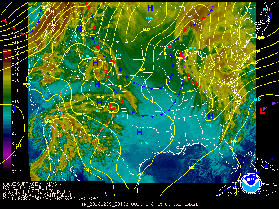
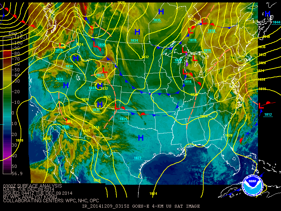
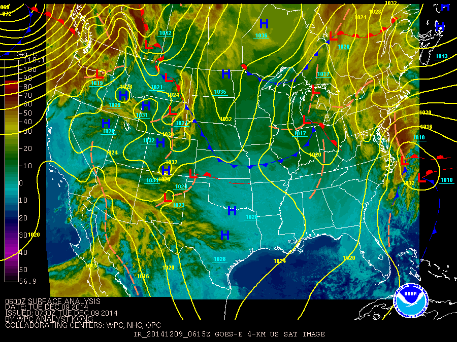
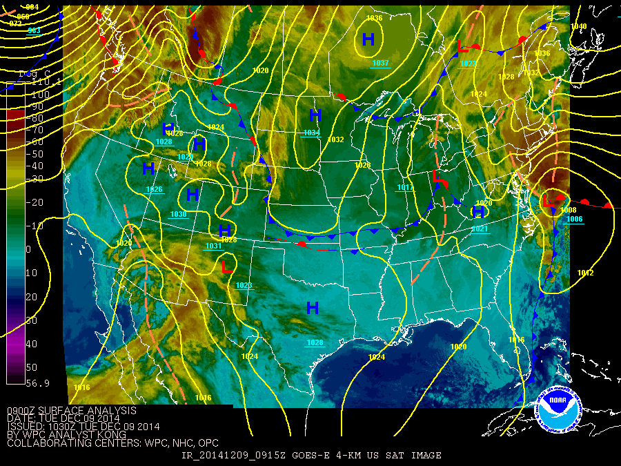
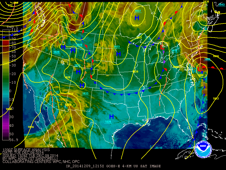
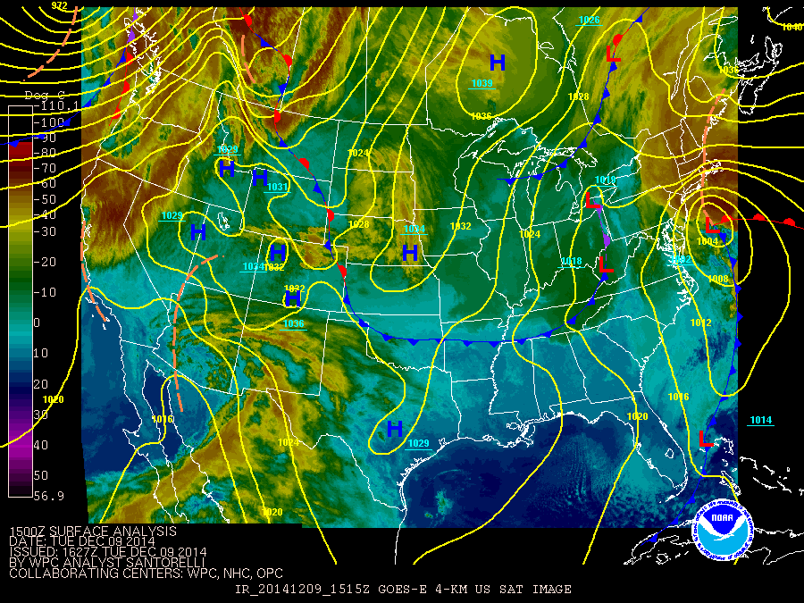
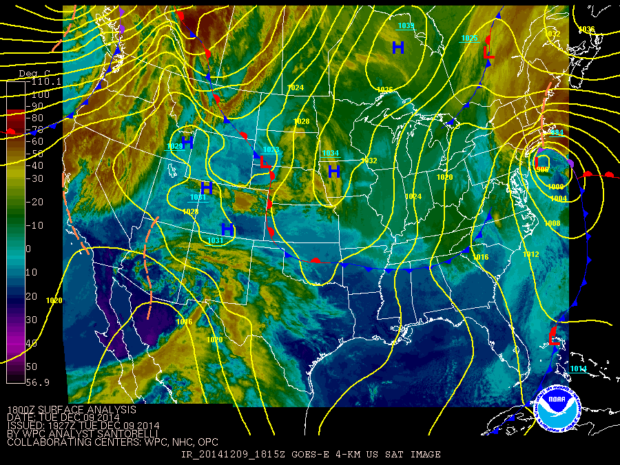
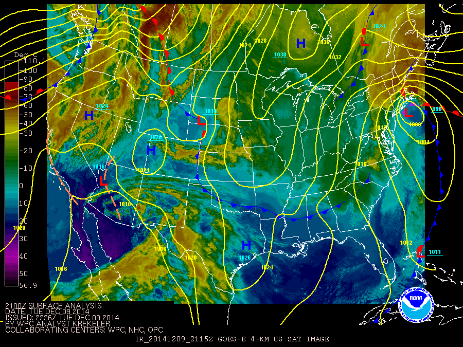
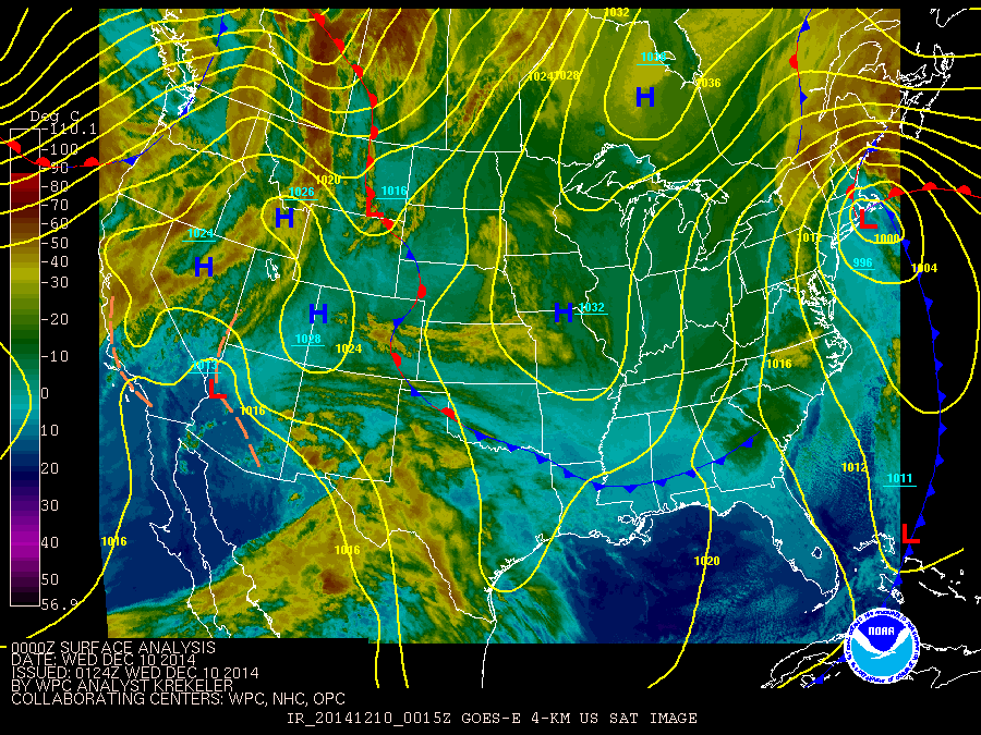
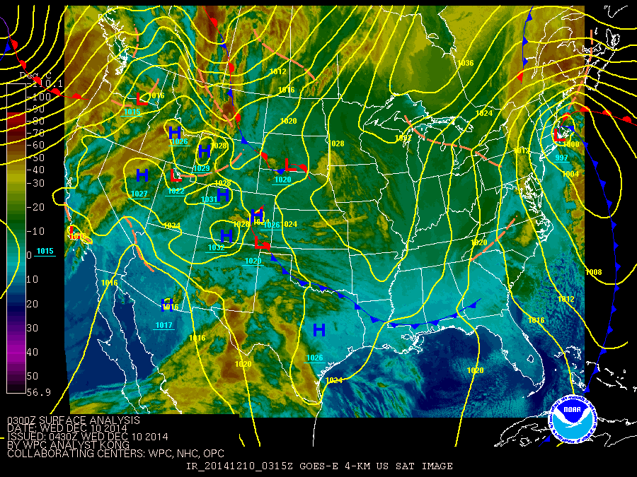
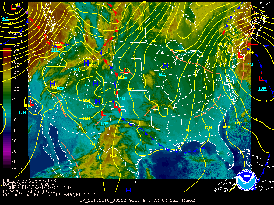
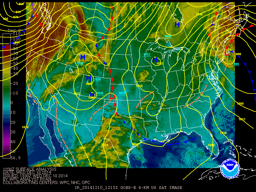
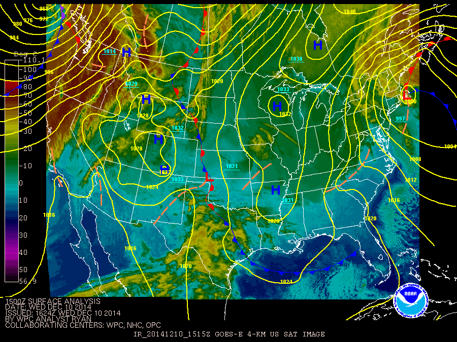
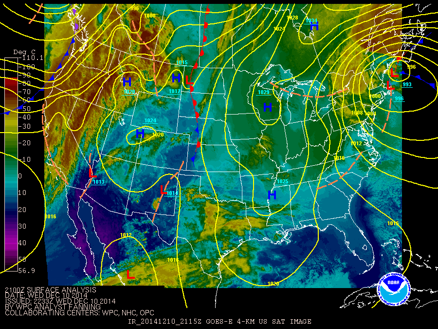
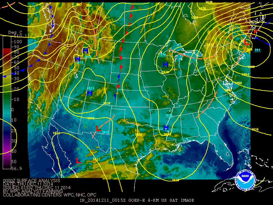
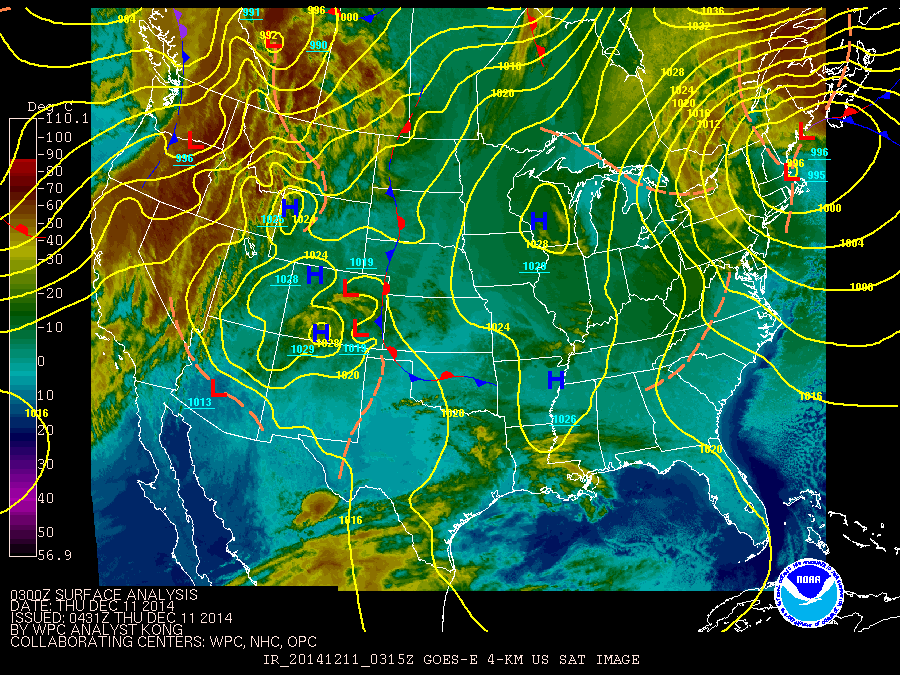
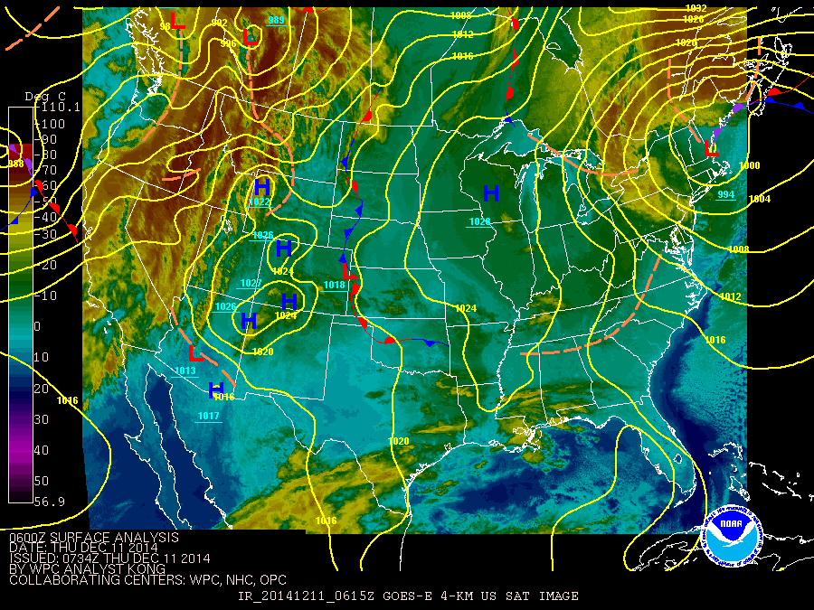
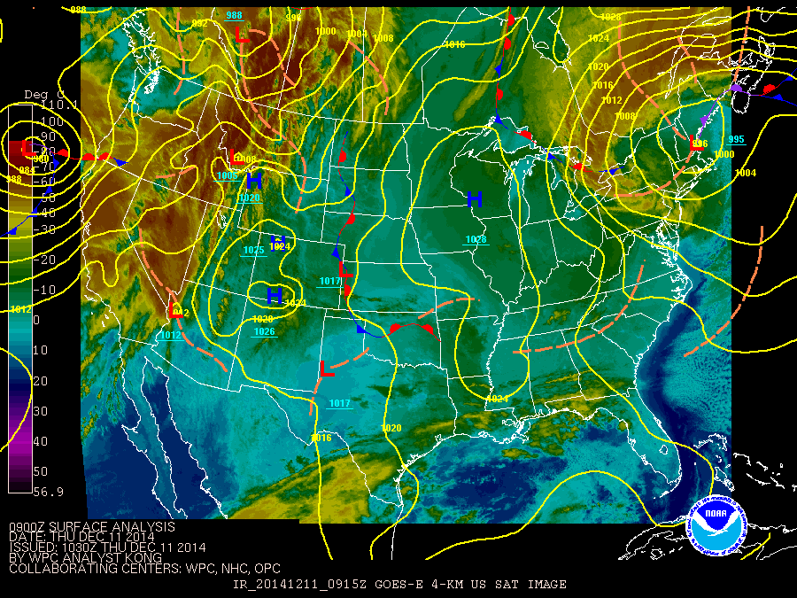
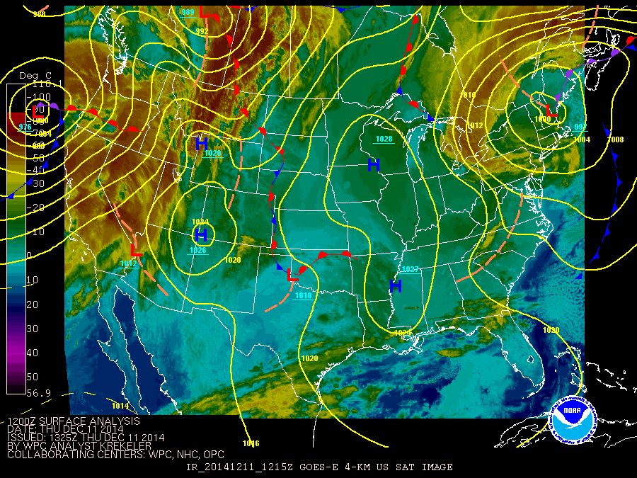
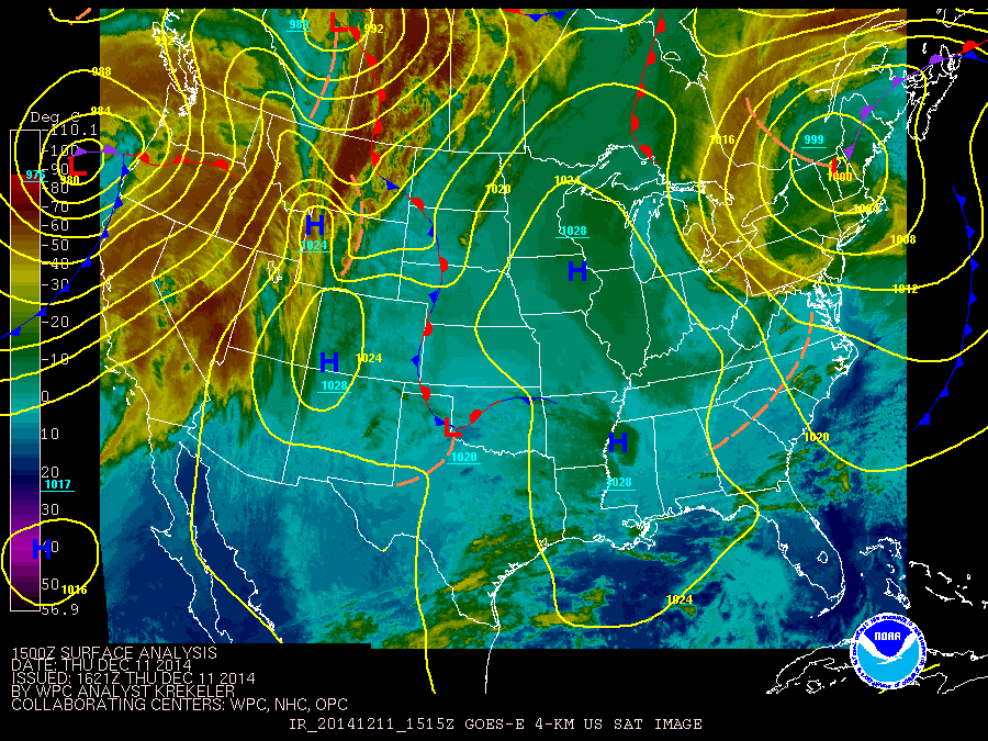
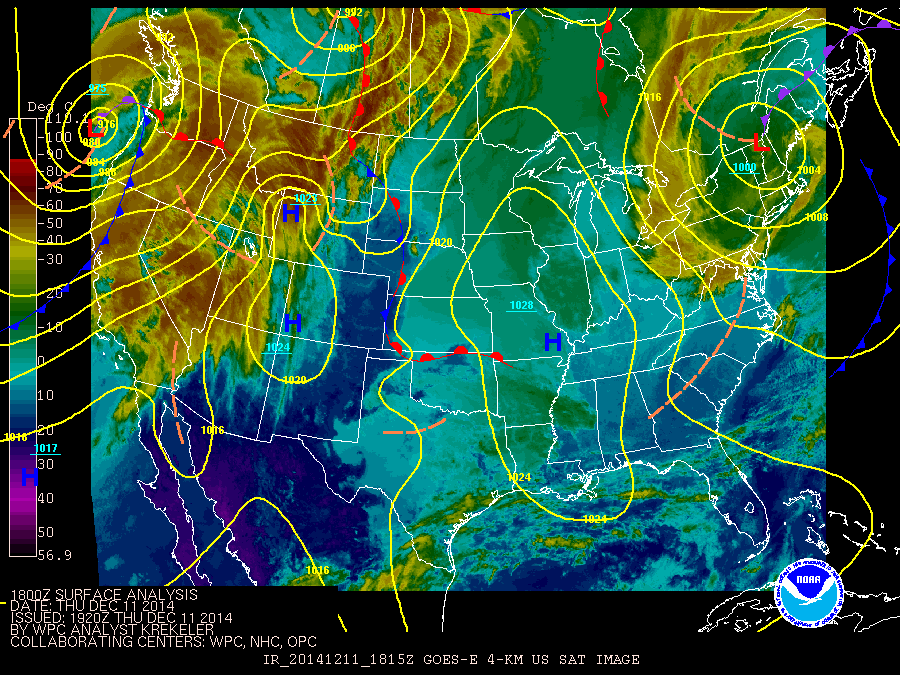
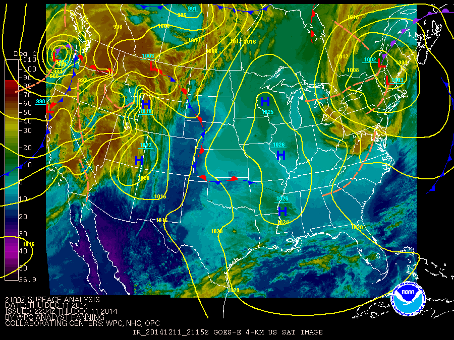
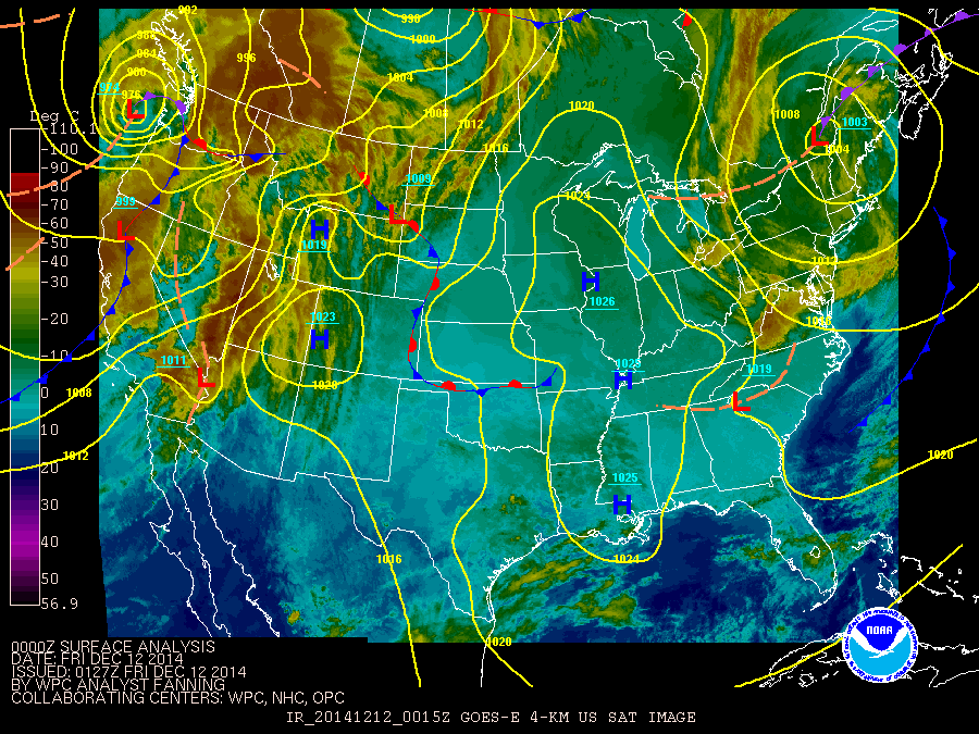
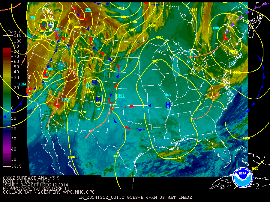
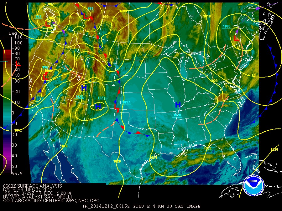
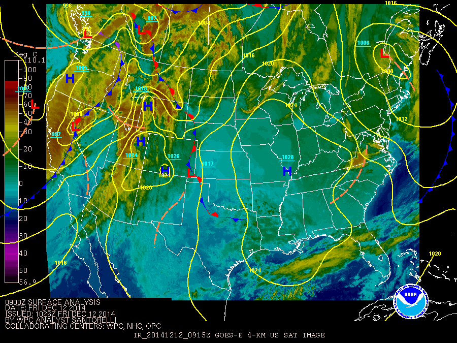
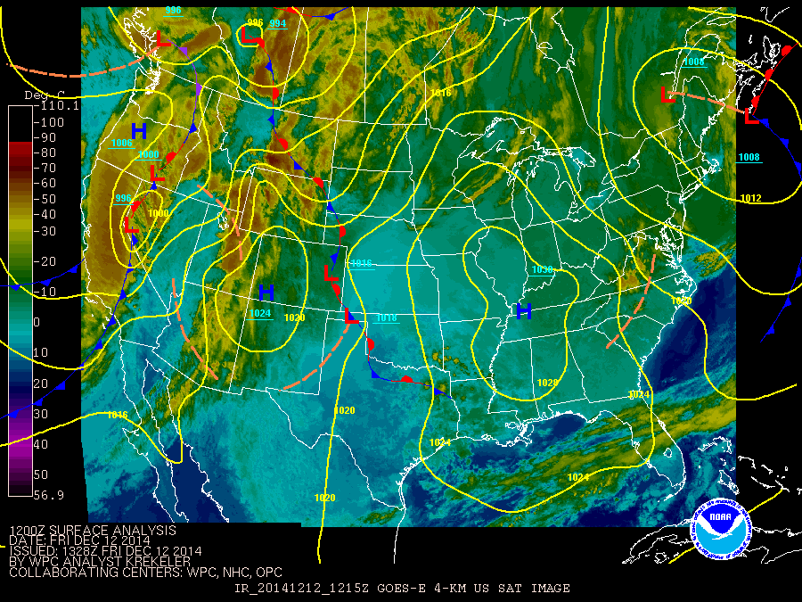
The loop below is map combination of satellite images and surface analysis. The storm system or Nor'easter moves northward along the east coast of the Unitied States.
Times on the images are in Zulu or UTC times. The loop starts at 0132Z December 9 or 08:32 PM EST December 8, to 1338Z December 12 or 08:28 AM EST December 12, 2014.
These images are from Weather Prediction Center's (https://www.wpc.ncep.noaa.gov/) archive web site.
Use the slider bar to control the speed of the loop.


Additional Links

