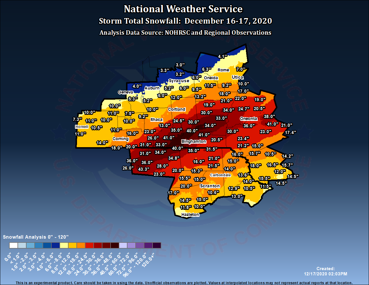
On December 16-17, 2020, a Nor’easter left behind a large footprint of double-digit snowfall totals across the interior Mid-Atlantic and Northeast regions. The heaviest snow fell in a narrow band thatstretched from north-central Pennsylvania to far southeastern Maine. Snowfall totals in excess of 30 inches were reported in this mesoscale snowband with localized amounts exceeding 40 inches across theSouthern Tier of New York, southern Vermont and New Hampshire. Numerous snowfall records were set with this storm including a new storm-total snowfall of 40” at Binghamton, New York. While the sheeramount of snow was extraordinary by itself, the short duration and intense snowfall rates adds to the remarkability of this event. Snowfall rates of 4 to 6 inches per hour for much of the night and earlymorning on 17 December resulted in snowfall totals near three feet in 12 hours. This amount of snow in a short period of time caused roads to become nearly impassible as snow plows could not keep up andeven in some instances became stuck.
Below is a map showing preliminary snowfall amounts across these areas. Click on map for a larger view.
...SNOWFALL REPORTS... Location Amount Time/Date Provider ...New York... ...Broome County... 2 SW Nws Binghamton 42.0 in 1028 AM 12/17 1 SSW Port Crane 41.0 in 0945 AM 12/17 Public Endwell 41.0 in 0859 AM 12/17 Trained Spotter 2 E Vestal 41.0 in 0830 AM 12/17 NWS Employee 2 S Binghamton 41.0 in 0800 AM 12/17 Public Endicott 40.5 in 0550 AM 12/17 Trained Spotter Nws Binghamton 40.0 in 0100 PM 12/17 Official NWS Obs 2 SW Vestal Center 40.0 in 0730 AM 12/17 NWS Employee West Corners 39.5 in 0649 AM 12/17 Public Vestal 37.9 in 0927 AM 12/17 Trained Spotter Johnson City 37.5 in 0858 AM 12/17 Trained Spotter Chenango Bridge 36.0 in 0742 AM 12/17 Public Chenango Forks 35.0 in 0415 AM 12/17 Public 2 SSE Vestal Center 35.0 in 0747 AM 12/17 Public 1 WSW Endwell 35.0 in 0510 AM 12/17 Public 1 SSW Port Dickinson 33.0 in 1249 PM 12/17 1 W Port Dickinson 32.0 in 0630 AM 12/17 Trained Spotter 2 NNE Johnson City 31.0 in 0500 AM 12/17 Public Binghamton 30.0 in 0925 AM 12/17 Trained Spotter Lisle 30.0 in 0626 AM 12/17 Public Chenango Forks 3.0 SE 29.8 in 0800 AM 12/17 COCORAHS 1 SW Chenango Bridge 29.0 in 0830 AM 12/17 Public Nanticoke 29.0 in 0636 AM 12/17 Public 1 WSW West Corners 28.5 in 0245 AM 12/17 NWS Employee 0.7 N Whitney Point 28.0 in 1000 AM 12/17 COOP Binghamton 1.3 ENE 27.5 in 1000 AM 12/17 COCORAHS 2 SE Union Center 27.0 in 0225 AM 12/17 NWS Employee Kirkwood 24.0 in 0625 AM 12/17 Public 2 ENE Lisle 23.0 in 0721 AM 12/17 Public Whitney Point 21.0 in 0157 AM 12/17 Public Windsor 20.5 in 1234 PM 12/17 Public ...Cayuga County... Aurora 2.4 N 5.2 in 0800 AM 12/17 COCORAHS Auburn 8.3 SSE 5.2 in 0600 AM 12/17 COCORAHS Auburn 4.8 in 0600 AM 12/17 COOP 2.0 N Cayuga 4.0 in 0645 AM 12/17 COOP Union Springs 4.0 in 0530 AM 12/17 Public Cayuga 4.0 NNE 3.3 in 0700 AM 12/17 COCORAHS ...Chemung County... 2 NW Waverly 31.0 in 0811 AM 12/17 Public 2 WSW Waverly 27.5 in 0700 AM 12/17 Trained Spotter 4 W Waverly 23.0 in 0900 AM 12/17 Public Van Etten 23.0 in 0730 AM 12/17 Public Elmira 21.5 in 0715 AM 12/17 Public 1 NE Southport 20.0 in 0845 AM 12/17 Public Elmira 19.0 in 0700 AM 12/17 Public Elmira 0.7 WNW 19.0 in 0650 AM 12/17 COCORAHS 1.0 NE West Elmira 18.7 in 0700 AM 12/17 COOP 1 SSE Horseheads 18.0 in 1112 AM 12/17 Trained Spotter Southport 18.0 in 0820 AM 12/17 Public Horseheads 16.0 in 0841 AM 12/17 Broadcast Media 3 NNE Swartwood 15.4 in 0700 AM 12/17 Public Erin 15.0 in 0847 AM 12/17 Trained Spotter 1 ESE Horseheads North 13.0 in 0200 AM 12/17 Broadcast Media ...Chenango County... Oxford 0.8 NNW 35.0 in 0800 AM 12/17 COCORAHS 3 NE Norwich 34.0 in 1030 AM 12/17 Public Greene 34.0 in 0700 AM 12/17 Trained Spotter Oxford 33.0 in 0700 AM 12/17 Trained Spotter Norwich 5.4 W 30.0 in 0700 AM 12/17 COCORAHS Preston 29.0 in 0700 AM 12/17 Trained Spotter Norwich 28.0 in 0706 AM 12/17 Trained Spotter Bainbridge 28.0 in 0700 AM 12/17 Trained Spotter 1 N Mt Upton 25.0 in 0455 AM 12/17 Public Coventry 22.0 in 0535 AM 12/17 Public Plymouth 22.0 in 0700 AM 12/17 Trained Spotter North Norwich 21.0 in 0704 AM 12/17 Trained Spotter Sherburne 21.0 in 0456 AM 12/17 Public Smyrna 19.0 in 0705 AM 12/17 Trained Spotter ...Cortland County... Marathon 24.5 in 1100 AM 12/17 Public Freetown 1.0 NE 16.0 in 0700 AM 12/17 COCORAHS 2 N Harford 15.0 in 0515 AM 12/17 Public 2 NW Mcgraw 12.3 in 0957 AM 12/17 Cortland 12.0 in 1107 AM 12/17 Trained Spotter Scott 12.0 in 0858 AM 12/17 Trained Spotter Cortland West 12.0 in 0600 AM 12/17 Homer 9.5 in 0900 AM 12/17 Trained Spotter ...Delaware County... 2 S Kortright 41.0 in 0703 AM 12/17 Trained Spotter Davenport 38.0 in 0703 AM 12/17 Trained Spotter Franklin 36.0 in 0640 AM 12/17 Public Sidney 30.0 in 0900 AM 12/17 Public Davenport Center 27.0 in 0830 AM 12/17 Public Meridale 27.0 in 0704 AM 12/17 Trained Spotter 1 SE Sidney 25.0 in 0745 AM 12/17 Trained Spotter Walton 6.5 W 23.4 in 0700 AM 12/17 COCORAHS 2 S Delhi 23.0 in 0800 AM 12/17 CO-OP Observer 2 NW Fishs Eddy 21.2 in 1043 AM 12/17 Hobart 4.8 ESE 21.0 in 0700 AM 12/17 COCORAHS Fleischmanns 5.7 N 17.4 in 0700 AM 12/17 COCORAHS Hancock 16.0 in 0758 AM 12/17 Public Long Eddy 6.5 NNE 15.7 in 0800 AM 12/17 COCORAHS 4 NW Cooks Falls 15.0 in 1019 AM 12/17 ...Madison County... South Brookfield 22.0 in 0700 AM 12/17 Public Hamilton 18.0 in 0718 AM 12/17 Public Erieville 13.2 in 1038 AM 12/17 Trained Spotter Nelson 11.5 in 0915 AM 12/17 Public Oneida 10.0 in 0857 AM 12/17 Trained Spotter Cazenovia 2.9 SE 9.5 in 0700 AM 12/17 COCORAHS 3 SE Perryville 7.8 in 0800 AM 12/17 Trained Spotter 1 WSW Sherrill 7.5 in 0944 AM 12/17 Public Chittenango 6.0 in 0736 AM 12/17 Trained Spotter 1 ENE Sullivan 5.6 in 0922 AM 12/17 Chittenango 2.1 ESE 5.0 in 0800 AM 12/17 COCORAHS ...Oneida County... 1 W Sauquoit 10.7 in 0643 AM 12/17 Trained Spotter Utica 10.5 in 1125 AM 12/17 Broadcast Media 1 SE Clinton 10.5 in 1003 AM 12/17 Trained Spotter 3 S Utica 10.0 in 0907 AM 12/17 Public Deerfield 9.5 in 1030 AM 12/17 Public Paris 9.2 in 1048 AM 12/17 Trained Spotter New Hartford 9.1 in 0601 AM 12/17 Trained Spotter Westmoreland 4 N 8.0 in 0700 AM 12/17 COOP Sherrill 8.0 in 0645 AM 12/17 Public Holland Patent 1.1 WNW 7.0 in 0700 AM 12/17 COCORAHS Durhamville 3.5 NNW 6.3 in 0700 AM 12/17 COCORAHS Rome 6.0 in 0700 AM 12/17 Trained Spotter 1 WSW Griffiss Afb 6.0 in 0700 AM 12/17 Trained Spotter Point Rock 0.6 SE 4.1 in 0730 AM 12/17 COCORAHS ...Onondaga County... Jamesville 6.0 in 0845 AM 12/17 Trained Spotter Skaneateles 9.1 SE 6.0 in 0700 AM 12/17 COCORAHS Marcellus 5.2 in 0811 AM 12/17 Trained Spotter Syracuse 5.0 in 0849 AM 12/17 Trained Spotter Camillus 1.0 W 4.8 in 0700 AM 12/17 COCORAHS Syracuse 2.7 S 4.7 in 0730 AM 12/17 COCORAHS Skaneateles 0.8 NNW 4.2 in 0710 AM 12/17 COCORAHS Westvale 4.0 in 0541 AM 12/17 Broadcast Media Clay 4.6 NW 3.5 in 0830 AM 12/17 COCORAHS Baldwinsville 3.3 NE 3.5 in 0800 AM 12/17 COCORAHS Brewerton 1.5 ESE 3.4 in 0815 AM 12/17 COCORAHS Baldwinsville 3.3 in 0900 AM 12/17 Trained Spotter Liverpool 4.5 N 3.2 in 0720 AM 12/17 COCORAHS Brewerton Lock 23 3.0 in 0700 AM 12/17 COOP ...Otsego County... Unadilla 31.4 in 0838 AM 12/17 Trained Spotter Gilbertsville 28.0 in 1045 AM 12/17 Public Emmons 27.1 in 0926 AM 12/17 Trained Spotter Schenevus 27.0 in 0702 AM 12/17 Trained Spotter Maryland 26.0 in 0630 AM 12/17 Public 2 NNW Emmons 25.5 in 0718 AM 12/17 Public Otego 25.0 in 0955 AM 12/17 Public Otego 25.0 in 1000 AM 12/17 Public Hartwick 24.7 in 0930 AM 12/17 COCORAHS 1 NNE Oneonta 24.5 in 1202 PM 12/17 Trained Spotter Oneonta 24.0 in 0800 AM 12/17 Public Edmeston 24.0 in 0550 AM 12/17 Public 3 NE Mt Vision 20.5 in 0500 AM 12/17 Public Cooperstown 19.0 in 0705 AM 12/17 Trained Spotter Unadilla Forks 17.0 in 0600 AM 12/17 Public ...Schuyler County... Mecklenburg 4 SW 12.0 in 0700 AM 12/17 COOP 1 WNW Odessa 11.8 in 1243 PM 12/17 Public Smith Valley 1.9 SE 11.4 in 0700 AM 12/17 COCORAHS 1 SSE Burdett 10.0 in 0630 AM 12/17 Trained Spotter Catharine 9.8 in 1108 AM 12/17 Trained Spotter Dundee 6.2 E 7.5 in 0700 AM 12/17 COCORAHS ...Seneca County... Fayette 5.3 in 0753 AM 12/17 Public ...Steuben County... Caton 18.0 in 0625 AM 12/17 Public Addison 14.0 in 0749 AM 12/17 Public Corning 14.0 in 0700 AM 12/17 Trained Spotter Painted Post 0.7 SSE 13.8 in 0600 AM 12/17 COCORAHS Campbell 13.0 in 0802 AM 12/17 Public Prattsburg 11.0 in 0830 AM 12/17 Trained Spotter Sonora 11.0 in 0800 AM 12/17 Trained Spotter Howard 11.0 in 0740 AM 12/17 Trained Spotter Canisteo 11.0 in 0838 AM 12/17 Trained Spotter Bath 4.2 E 11.0 in 0700 AM 12/17 COCORAHS Bath 10.5 in 1045 AM 12/17 Public Cohocton 10.0 in 0800 AM 12/17 Trained Spotter Kanona 10.0 in 0700 AM 12/17 Trained Spotter Avoca 9.5 in 0736 AM 12/17 Trained Spotter Hornell 9.3 in 0825 AM 12/17 Trained Spotter Arkport 7.3 in 0832 AM 12/17 Trained Spotter ...Sullivan County... Kiamesha 16.5 in 0800 AM 12/17 Public Woodridge 15.7 in 0756 AM 12/17 Trained Spotter Glen Spey 15.5 in 0700 AM 12/17 Trained Spotter Wurtsboro 14.5 in 0755 AM 12/17 Trained Spotter 3 SE Hartwood 14.5 in 0654 AM 12/17 Public Grahamsville 14.2 in 0800 AM 12/17 Trained Spotter Monticello 12.0 in 0800 AM 12/17 Public Parksville 10.5 in 0659 AM 12/17 Trained Spotter ...Tioga County... 2 SE Newark Valley 44.0 in 0700 AM 12/17 Public 1 NNE Tioga Terrace 43.0 in 0945 AM 12/17 Trained Spotter 1 N Foster 41.2 in 1250 PM 12/17 NWS Employee Owego 41.0 in 0815 AM 12/17 Public 2 ESE Campville 40.5 in 0905 AM 12/17 1 ENE Owego 39.0 in 0915 AM 12/17 Public 3 WNW Foster 39.0 in 0800 AM 12/17 Public Apalachin 38.0 in 0510 AM 12/17 Public 1 NW Tioga Terrace 37.0 in 0730 AM 12/17 Public Tioga Terrace 37.0 in 1037 AM 12/17 Trained Spotter Owego 35.0 in 0700 AM 12/17 Public Newark Valley 35.0 in 0515 AM 12/17 Public Waverly 33.7 in 1019 AM 12/17 Trained Spotter 1 ENE Waverly 28.0 in 1055 AM 12/17 Lockwood 26.0 in 0631 AM 12/17 Public Candor 25.0 in 0900 AM 12/17 Public Berkshire 2.0 N 25.0 in 0730 AM 12/17 COCORAHS Berkshire 25.0 in 0730 AM 12/17 Trained Spotter Berkshire 24.8 in 0630 AM 12/17 Public Candor 1.8 N 24.5 in 0700 AM 12/17 COCORAHS 2 NNW Berkshire 23.0 in 0858 AM 12/17 Public ...Tompkins County... Newfield Hamlet 4.3 S 16.0 in 0900 AM 12/17 COCORAHS Freeville 16.0 in 0640 AM 12/17 Public Jacksonville 14.0 in 0900 AM 12/17 Trained Spotter 3 S Newfield Hamlet 13.9 in 1124 AM 12/17 Danby 13.0 in 1045 AM 12/17 Public Ithaca 6.4 E 13.0 in 0730 AM 12/17 COCORAHS Ithaca 5.4 SSW 12.8 in 0700 AM 12/17 COCORAHS Ithaca 1.1 SE 11.3 in 0700 AM 12/17 COCORAHS 1 E Northeast Ithaca 11.0 in 0925 AM 12/17 Trained Spotter Ithaca 11.0 in 0750 AM 12/17 Public Etna 11.0 in 0730 AM 12/17 Public Groton 10.5 in 0730 AM 12/17 Public Freeville 1.5 NE 10.5 in 0700 AM 12/17 COCORAHS Groton 3.2 SSW 10.2 in 0800 AM 12/17 COCORAHS 1.1 E Forest Home 10.2 in 0700 AM 12/17 COOP 1 NE Trumansburg 10.0 in 0830 AM 12/17 Public Ithaca 2.0 ESE 9.8 in 0800 AM 12/17 COCORAHS Trumansburg 0.4 WNW 9.2 in 0700 AM 12/17 COCORAHS Lansing 8.5 in 0933 AM 12/17 Trained Spotter ...Yates County... Branchport 10.0 in 0851 AM 12/17 Trained Spotter Italy Hill 8.5 in 0500 AM 12/17 Public Middlesex 3.5 S 7.0 in 0900 AM 12/17 COCORAHS Penn Yan 6.0 in 0445 AM 12/17 Public Benton 5.0 in 0942 AM 12/17 Trained Spotter ...Pennsylvania... ...Bradford County... 3 ENE Alba 43.3 in 0700 AM 12/17 Public Burlington 6.1 SW 36.0 in 0445 AM 12/17 COCORAHS Troy 36.0 in 0600 AM 12/17 Public Rome 34.8 in 0730 AM 12/17 Public Litchfield 34.0 in 1045 AM 12/17 Public Sayre 34.0 in 0900 AM 12/17 Public 1 NE Sayre 33.0 in 0903 AM 12/17 Ridgebury 31.0 in 0647 AM 12/17 Public Towanda 28.0 in 0947 AM 12/17 CO-OP Observer Alba 26.0 in 0420 AM 12/17 Trained Spotter 3 W South Branch 23.0 in 1132 AM 12/17 Trained Spotter 3 WSW Browntown 20.0 in 0456 AM 12/17 Public ...Lackawanna County... East Benton 20.0 in 0700 AM 12/17 Public Vandling 0.1 NNE 14.0 in 0700 AM 12/17 COCORAHS Olyphant 11.2 in 0830 AM 12/17 Trained Spotter 1 NE Moosic 11.0 in 0945 AM 12/17 Official NWS Obs Scranton 11.0 in 0713 AM 12/17 Public Clarks Green 0.5 N 10.8 in 0930 AM 12/17 COCORAHS Moosic 10.6 in 0735 AM 12/17 Trained Spotter Clarks Summit 10.0 in 0740 AM 12/17 Public Clarks Summit 9.7 in 0530 AM 12/17 Trained Spotter 1 E West Scranton 9.3 in 0712 AM 12/17 Trained Spotter Throop 9.3 in 0830 AM 12/17 Public Dickson City 6.8 in 1040 AM 12/17 Trained Spotter ...Luzerne County... 1 S Harveys Lake 20.0 in 0935 AM 12/17 Harveys Lake 17.5 in 0900 AM 12/17 Trained Spotter Sweet Valley 17.0 in 0700 AM 12/17 Trained Spotter 1 SW Wilkes-Barre 15.0 in 1037 AM 12/17 1 NNW West Pittston 15.0 in 1028 AM 12/17 Exeter 15.0 in 1020 AM 12/17 Trained Spotter Ashley 15.0 in 0800 AM 12/17 Public 1 NNW Sugar Notch 14.5 in 0830 AM 12/17 Public Edwardsville 14.2 in 0700 AM 12/17 Trained Spotter Shavertown 14.0 in 0830 AM 12/17 Public Lehman 14.0 in 0700 AM 12/17 Trained Spotter Mountain Top 1.0 SW 12.7 in 0950 AM 12/17 COCORAHS Harveys Lake 12.0 in 0530 AM 12/17 Trained Spotter Forty Fort 12.0 in 0900 AM 12/17 Public 1 NNW Courtdale 12.0 in 0800 AM 12/17 Public Dallas 12.0 in 0700 AM 12/17 Trained Spotter Drums 11.8 in 1045 AM 12/17 Trained Spotter 1 NW Ashley 11.4 in 0700 AM 12/17 Trained Spotter Duryea 0.3 SE 11.0 in 0500 AM 12/17 COCORAHS Pittston 11.0 in 0700 AM 12/17 Public 1 SE Albert 10.0 in 0619 AM 12/17 Public ...Pike County... Milford 8.7 NW 11.5 in 0700 AM 12/17 COCORAHS Blooming Grove 10.5 in 0626 AM 12/17 Trained Spotter ...Susquehanna County... Hallstead 31.5 in 0858 AM 12/17 Trained Spotter Susquehanna 23.5 in 0900 AM 12/17 Trained Spotter New Milford 22.0 in 0900 AM 12/17 Trained Spotter 1 NE Susquehanna 22.0 in 0836 AM 12/17 Trained Spotter Lenoxville 21.5 in 0217 AM 12/17 Public New Milford 1.6 SSE 21.0 in 0915 AM 12/17 COCORAHS 2 ESE Birchardville 19.5 in 0813 AM 12/17 Public Harford 1.4 NNE 18.9 in 0730 AM 12/17 COCORAHS 1 N Montrose 18.0 in 0400 AM 12/17 Public 1 WNW Montrose 16.0 in 0900 AM 12/17 Trained Spotter Forest City 14.0 in 0630 AM 12/17 Public ...Wayne County... Damascus 18.0 in 0600 AM 12/17 Trained Spotter Lakewood 16.0 in 0621 AM 12/17 Trained Spotter Equinunk 15.0 in 0621 AM 12/17 Trained Spotter 2 W Hawley 14.0 in 1100 AM 12/17 Trained Spotter Hawley 14.0 in 0901 AM 12/17 Trained Spotter Honesdale 13.6 in 1000 AM 12/17 Trained Spotter Newfoundland 13.0 in 0625 AM 12/17 Trained Spotter 1 W Greentown 12.9 in 0640 AM 12/17 Public Dyberry - 19 12.8 in 0700 AM 12/17 COCORAHS Prompton 11.6 in 0700 AM 12/17 COOP ...Wyoming County... Falls 16.0 in 0800 AM 12/17 Trained Spotter Tunkhannock 15.5 in 0629 AM 12/17 Public Nicholson 15.3 in 0645 AM 12/17 Public Factoryville 15.0 in 0745 AM 12/17 Trained Spotter && Observations are collected from a variety of sources with varying equipment and exposures. We thank all volunteer weather observers for their dedication. Not all data listed are considered official. THIS WILL BE THE FINAL SUMMARY FOR THIS STORM. Thanks, everyone.
NOTE: A band of higher reflectivity develops in a southwest to northeast orientation over the radar site, shown in yellow. This is where the highest snowfall rates were occurring. Snowfall amounts ranged from 30 to 45 inches in total in the band area.
There is no audio with this video.
>

