A strong storm system moved across the area producing heavy snowfall across parts of central NY and northeast Pennsylvania on March 11 through 12, 2022. Below is a map showing snowfall amounts. Click on the map for a larger view.
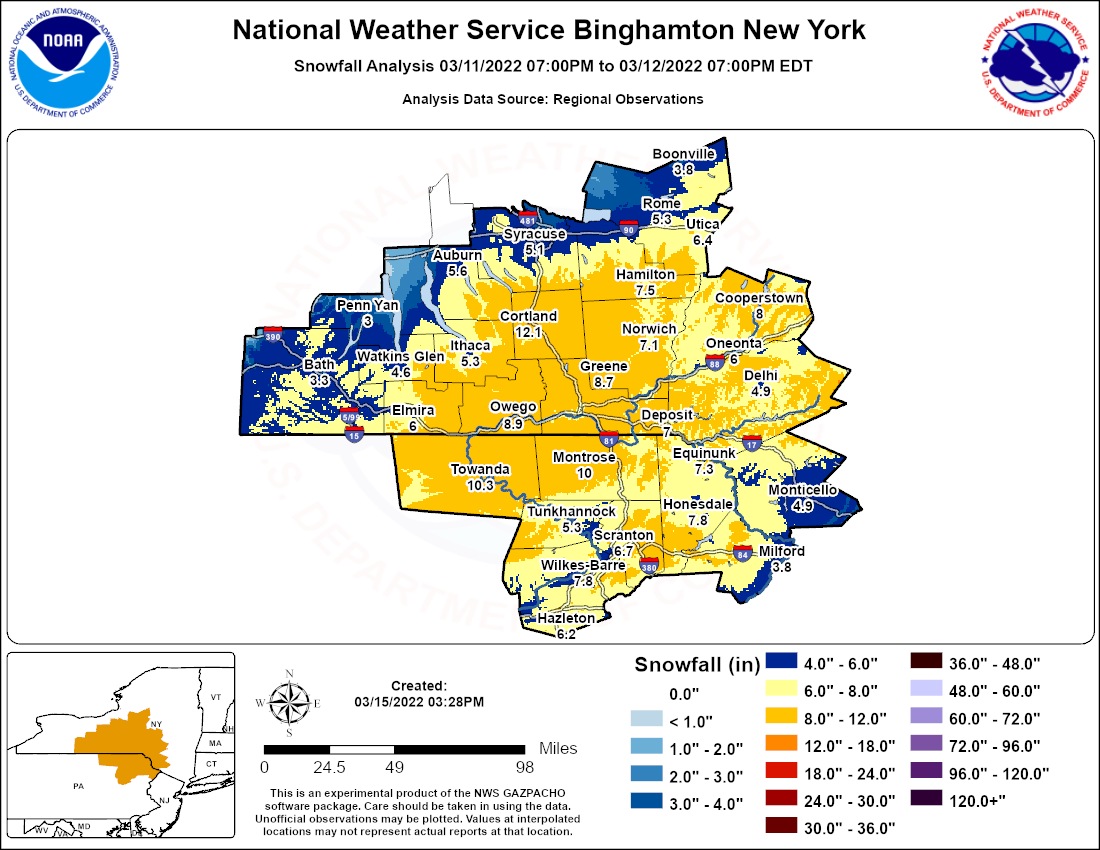
Below is some of the data used to create the map above.
Public Information Statement
National Weather Service Binghamton NY
1105 AM EDT Sun Mar 13 2022

...SNOWFALL REPORTS...

Location                     Amount    Time/Date       Lat/Lon

...New York...

...Broome County...
1 N Conklin                  12.0 in   0200 PM 03/12   42.05N/75.80W
1 SE Union Center            10.7 in   0315 PM 03/12   42.14N/76.04W
Whitney Point                10.5 in   0200 PM 03/12   42.33N/75.97W
NWS Binghamton               10.4 in   0700 PM 03/12   42.21N/75.99W
2 NE Port Crane              10.2 in   0415 PM 03/12   42.19N/75.81W
2 SSW Lisle                  9.7 in    0430 PM 03/12   42.33N/76.02W
Port Crane                   9.5 in    0513 PM 03/12   42.17N/75.83W
Conklin                      9.5 in    0330 PM 03/12   42.03N/75.80W
West Corners                 9.4 in    0140 PM 03/12   42.12N/76.07W
Vestal Center                9.1 in    0312 PM 03/12   42.03N/76.02W
Vestal                       9.0 in    0115 PM 03/12   42.08N/76.05W
2 NW Johnson City            8.5 in    0333 PM 03/12   42.15N/76.00W
1 WNW Johnson City           8.3 in    0300 PM 03/12   42.13N/75.98W
1 NW Endwell                 7.8 in    0520 PM 03/12   42.13N/76.04W
Windsor                      7.5 in    1201 PM 03/12   42.08N/75.64W
Binghamton                   7.3 in    1236 PM 03/12   42.10N/75.91W
Vestal                       7.0 in    0115 PM 03/12   42.08N/76.05W
Port Dickinson               6.5 in    0700 PM 03/12   42.14N/75.90W
Vestal                       6.0 in    1234 PM 03/12   42.08N/76.05W

...Chemung County...
Elmira                       6.0 in    0140 PM 03/12   42.09N/76.81W

...Chenango County...
Bainbridge                   10.0 in   0530 PM 03/12   42.30N/75.48W
1 NE Harpursville            7.8 in    0205 PM 03/12   42.20N/75.60W
1 NE Harpursville            7.2 in    1240 PM 03/12   42.20N/75.60W
New Berlin                   7.0 in    0110 PM 03/12   42.63N/75.33W
Afton                        6.0 in    1243 PM 03/12   42.23N/75.53W

...Cortland County...
Cortland                     12.1 in   1058 AM 03/13   42.60N/76.18W
2 WNW Mcgraw                 10.2 in   0335 PM 03/12   42.60N/76.13W
Marathon                     9.0 in    0345 PM 03/12   42.44N/76.03W
Virgil                       8.0 in    0200 PM 03/12   42.52N/76.19W
Virgil                       8.0 in    0122 PM 03/12   42.52N/76.18W

...Delaware County...
3 WNW Meridale               9.0 in    0300 PM 03/12   42.38N/75.00W
East Meredith                8.0 in    0200 PM 03/12   42.42N/74.88W
1 NNE Davenport Center       6.0 in    0300 PM 03/12   42.46N/74.91W
5 NW Stamford                5.5 in    0452 PM 03/12   42.47N/74.68W
Delhi                        5.3 in    1230 PM 03/12   42.28N/74.91W

...Madison County...
Hamilton                     7.5 in    1200 PM 03/12   42.83N/75.54W
Chittenango                  5.3 in    1241 PM 03/12   43.05N/75.87W

...Oneida County...
New York Mills               9.2 in    0200 PM 03/12   43.10N/75.29W
Waterville                   9.0 in    0240 PM 03/12   42.93N/75.38W
2 E Paris                    7.2 in    0300 PM 03/12   43.00N/75.29W
Barneveld                    7.0 in    0500 PM 03/12   43.27N/75.19W
New Hartford                 7.0 in    0500 PM 03/12   43.07N/75.29W
Holland Patent               6.0 in    0700 PM 03/12   43.24N/75.26W
2 E Bridgewater              6.0 in    0230 PM 03/12   42.88N/75.21W
1 NNW Maynard                5.5 in    0130 PM 03/12   43.14N/75.27W
Whitesboro                   5.1 in    1211 PM 03/12   43.12N/75.30W
1 S Trenton Falls            5.0 in    0310 PM 03/12   43.25N/75.17W
1 SE Point Rock              3.9 in    0400 PM 03/12   43.37N/75.54W

...Onondaga County...
Baldwinsville                6.5 in    0126 PM 03/12   43.16N/76.33W
1 S Onondaga                 5.5 in    0151 PM 03/12   42.99N/76.18W
Syracuse                     5.1 in    0100 PM 03/12   43.04N/76.14W
2 SE North Syracuse          3.5 in    0500 PM 03/12   43.11N/76.11W

...Otsego County...
Richfield Springs            10.0 in   0500 PM 03/12   42.85N/74.99W
1 NW Unadilla                8.1 in    0400 PM 03/12   42.33N/75.33W
Milford                      8.0 in    0305 PM 03/12   42.59N/74.95W
West End                     8.0 in    0300 PM 03/12   42.47N/75.09W
3 E New Lisbon               8.0 in    0245 PM 03/12   42.58N/75.13W
Cooperstown                  8.0 in    0500 PM 03/12   42.70N/74.93W
Cherry Valley                7.0 in    0300 PM 03/12   42.80N/74.75W
Schenevus                    7.0 in    0255 PM 03/12   42.55N/74.83W
1 N Laurens                  7.0 in    0230 PM 03/12   42.55N/75.09W
Oneonta                      7.0 in    0500 PM 03/12   42.45N/75.07W
2 S Laurens                  6.5 in    0245 PM 03/12   42.51N/75.09W
Unadilla                     6.0 in    0315 PM 03/12   42.33N/75.31W
2 NW Wells Bridge            6.0 in    0230 PM 03/12   42.38N/75.27W
Oneonta                      6.0 in    0200 PM 03/12   42.45N/75.06W

...Steuben County...
3 NNE West Cameron           7.0 in    0800 PM 03/12   42.27N/77.42W
2 NW Prattsburg              7.0 in    0129 PM 03/12   42.54N/77.30W
Sonora                       5.8 in    0800 PM 03/12   42.33N/77.17W
1 ESE Hornell                4.8 in    0800 PM 03/12   42.32N/77.65W
1 S Kanona                   4.8 in    0300 PM 03/12   42.37N/77.37W
Corning                      4.0 in    0345 PM 03/12   42.15N/77.06W
1 E Bath                     3.0 in    0800 PM 03/12   42.34N/77.29W
Arkport                      3.0 in    0800 PM 03/12   42.40N/77.70W

...Sullivan County...
Callicoon Center             6.5 in    0530 PM 03/12   41.83N/74.97W
Kiamesha                     4.5 in    0300 PM 03/12   41.68N/74.65W

...Tioga County...
1 E Nichols                  12.0 in   0330 PM 03/12   42.02N/76.35W
Barton                       11.0 in   0245 PM 03/12   42.05N/76.45W
Apalachin                    10.0 in   0900 PM 03/12   42.07N/76.17W
Berkshire                    9.5 in    0325 PM 03/12   42.30N/76.18W
Waverly                      9.2 in    0123 PM 03/12   42.01N/76.54W
Waverly                      9.2 in    1244 PM 03/12   42.01N/76.54W
2 NW Candor                  9.0 in    0300 PM 03/12   42.25N/76.36W
Berkshire                    8.5 in    0400 PM 03/12   42.30N/76.18W
1 ESE Nichols                8.3 in    0110 PM 03/12   42.02N/76.35W
Tioga Terrace                8.0 in    1209 PM 03/12   42.05N/76.12W

...Tompkins County...
3 NNE Besemer                10.0 in   0311 PM 03/12   42.44N/76.39W
Etna                         7.0 in    0155 PM 03/12   42.48N/76.38W
Ithaca                       5.0 in    1211 PM 03/12   42.44N/76.50W

...Yates County...
Bluff Point                  4.5 in    0148 PM 03/12   42.62N/77.12W

...Pennsylvania...

...Bradford County...
Athens                       11.0 in   0900 PM 03/12   41.95N/76.52W
Towanda                      10.3 in   0200 PM 03/12   41.77N/76.45W
1 S Sayre                    10.0 in   1200 PM 03/12   41.98N/76.52W
Ridgebury                    9.8 in    0121 PM 03/12   41.97N/76.72W
Alba                         7.0 in    0220 PM 03/12   41.70N/76.83W

...Lackawanna County...
1 E Moscow                   11.0 in   0600 PM 03/12   41.34N/75.52W
Archbald                     8.0 in    0400 PM 03/12   41.51N/75.54W
1 NNE Yostville              7.0 in    0535 PM 03/12   41.32N/75.56W
1 W Vandling                 7.0 in    0514 PM 03/12   41.63N/75.48W
2 WNW Dunmore                7.0 in    0500 PM 03/12   41.43N/75.64W
1 SSW Oakhill                6.0 in    0700 PM 03/12   41.35N/75.73W
Moosic                       6.0 in    0700 PM 03/12   41.36N/75.70W
Archbald                     5.0 in    1201 PM 03/12   41.51N/75.54W

...Luzerne County...
Wilkes-Barre                 8.6 in    0400 PM 03/12   41.25N/75.88W
Drums                        7.6 in    0335 PM 03/12   41.02N/76.00W
Exeter                       7.0 in    0330 PM 03/12   41.33N/75.82W
1 N Penobscot                6.8 in    0645 PM 03/12   41.18N/75.88W
Drums                        6.1 in    1218 PM 03/12   41.02N/76.00W
Hazleton                     6.0 in    0126 PM 03/12   40.95N/75.97W
Wilkes-Barre                 6.0 in    1237 PM 03/12   41.25N/75.88W
Laurel Run                   5.5 in    0550 PM 03/12   41.22N/75.85W
Pringle                      5.5 in    0400 PM 03/12   41.28N/75.90W
Kingston                     5.5 in    0500 PM 03/12   41.27N/75.89W
Nanticoke                    5.4 in    1209 PM 03/12   41.20N/76.00W
2 NNW Sugar Notch            5.0 in    0430 PM 03/12   41.21N/75.94W
Duryea                       4.5 in    0420 PM 03/12   41.35N/75.77W

...Pike County...
1 NE Rowland                 8.5 in    0600 PM 03/12   41.48N/75.04W
Lords Valley                 8.0 in    0600 PM 03/12   41.37N/75.06W
1 NE Paupack                 6.0 in    0600 PM 03/12   41.41N/75.18W
2 WSW Milford                5.3 in    0900 PM 03/12   41.31N/74.84W
Milford                      4.0 in    0600 PM 03/12   41.32N/74.80W

...Susquehanna County...
Hallstead                    9.0 in    0600 PM 03/12   41.96N/75.75W
Susquehanna                  6.5 in    0125 PM 03/12   41.93N/75.60W
Forest City                  6.5 in    0119 PM 03/12   41.65N/75.47W
1 NNW Susquehanna            6.0 in    0400 PM 03/12   41.95N/75.61W

...Wayne County...
Lakeville                    10.5 in   0600 PM 03/12   41.44N/75.28W
1 N Lake Ariel               8.5 in    0600 PM 03/12   41.46N/75.38W
2 NE Orson                   8.0 in    0600 PM 03/12   41.84N/75.42W
Honesdale                    8.0 in    0600 PM 03/12   41.57N/75.26W
Equinunk                     8.0 in    0600 PM 03/12   41.85N/75.22W
4 NNW Hawley                 7.0 in    0600 PM 03/12   41.53N/75.20W
Hawley                       7.0 in    0600 PM 03/12   41.48N/75.18W
Beach Lake                   5.9 in    0145 PM 03/12   41.60N/75.15W
2 NE Bethany                 5.5 in    0600 PM 03/12   41.64N/75.26W
2 S Laurella                 5.4 in    0645 PM 03/12   41.56N/75.22W

...Wyoming County...
1 ESE Mill City              5.5 in    0400 PM 03/12   41.49N/75.83W
&&
Radar reflectivity loop from the National Weather Service Radar at Binghamton, NY (KBGM). This loop shows a storm system moving across the area producing heavy snowfall across parts of central NY and northeast Pennsylvania. Note as the main area of snow moves out of the area, lake effect snow bands develop near the end of the video. The loop is from 07:05 PM EST March 11, 2022 to 06:58 PM EST March 12, 2022.
There is no audio with this video.
This shows a storm system that moves across the eastern half of the United States. This produced heavy snow across parts of New York and Pennsylvania on March 12, 2022. The loop is from 07:01 PM EST March 10, 2022 to 07:56 PM EDT March 13, 2022.
There is no audio with this video.

