Alabama Tornado Database |
|||||||||||
| 2014 Tornado Occurrences (54) () Indicates Total Path Data Multi-State | |||||||||||
| Tornado # of Year | Year | Month | Day | Start Time (CST) | County(s) | Damage Scale | Path Length (Miles) | Max Path Width (Yards) | Fatalities | Injuries | Location |
|
54
|
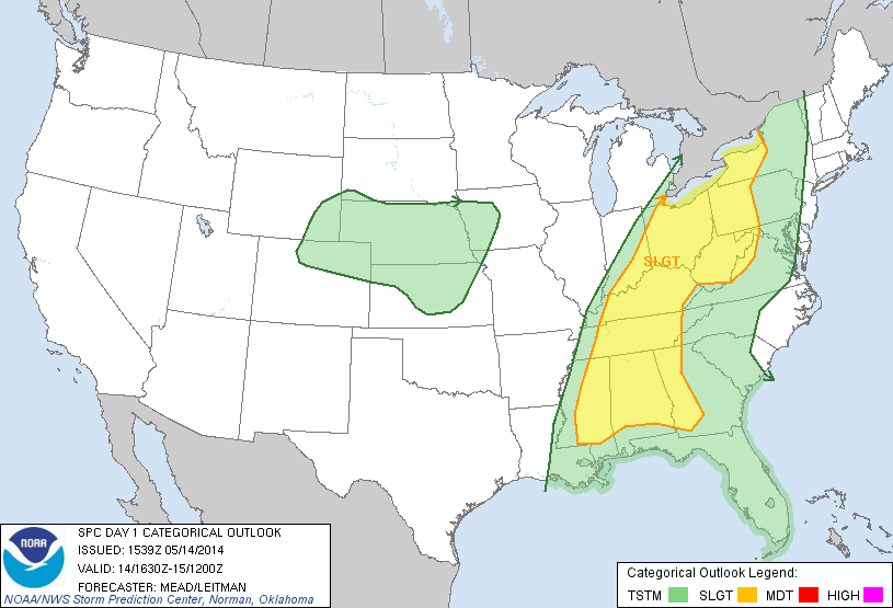
2014 | 11 | 23 | 1403 | Barbour Event Overview Event Information Georgia Information Tornado continued into Georgia Slight Risk |
F1 (F1) Polygon Warnings Tornado Watch |
3.23 (16.72) |
400 (400) |
0 (0) |
0 (1) |
2.2 ENE Eufaula Weedon Airport - 2 E Wylaunee This brief tornado touched down just south of Firetower Road, then crossed the road and dissipated quickly just to the north. Damage was limited to mainly minor tree damage. However, one concentrated area at the center of the path had a grove of small to medium hardwood trees that were snapped. One larger hardwood was uprooted in the same location. Power lines were also knocked down along Firetower Road. Special thanks to the Russell County Emergency Management Agency for assisting in the completion of the storm survey. Start: 31.9603/-85.0940 End: 32.0002/-85.0653 |
|
53
|
2014 | 11 | 23 | 1135 | Greene Event Overview Event Information Slight Risk |
F0 Polygon Warnings |
2.05 | 150 | 0 | 0 | 2.6 ESE Forkland - 3.4 ENE Forkland The tornado began about 2.4 miles east-southeast of Forkland, just south of County Road 20 near the northern edge of catfish ponds, where a person observed the tornado. From there, it moved north-northeast and ended near Lloyd Chapel Church along County Road 41. Several trees were either snapped or uprooted along the path. Additionally, a small tornado debris signature was evident in dual-pol data from KBMX radar. Start: 32.6387/-87.8364 End: 32.6669/-87.8255 |
|
52
|
2014 | 11 | 17 | 0624 | Russell Event Overview Event Information Small Risk |
F1 Polygon Warnings Tornado Watch |
0.22 | 100 | 0 | 0 | 1.7 W Loflin - 1.6 W Loflin This brief tornado touched down just south of Firetower Road, then crossed the road and dissipated quickly just to the north. Damage was limited to mainly minor tree damage. However, one concentrated area at the center of the path had a grove of small to medium hardwood trees that were snapped. One larger hardwood was uprooted in the same location. Power lines were also knocked down along Firetower Road. Special thanks to the Russell County Emergency Management Agency for assisting in the completion of the storm survey. Start: 32.1990/-85.0592 End: 32.2011/-85.0564 |
|
51
|
2014 | 11 | 17 | 0445 | Crenshaw-Pike-Bullock Event Overview Event Information Slight Risk |
F1 Polygon Warnings Tornado Watch |
40.73 | 500 | 0 | 0 | 2.4 SSW Blackrock - 0.6 ENE Postoak The tornado first touched own on Cook Stand Road just east of the Butler County line. Several homes experienced significant damage due to downed trees. A double wide manufactured home was shifted off its blocks . The tornado tracked east northeast across highway 10 where it produced minor shingle damage and broken windows to a single family home. the tornado continued northeast producing sporadic tree damage. A chicken house was destroyed on Quail Tower Road . The tornado intensified again as it crossed highway 331. Numerous chicken houses were destroyed on CR 50 and Cross Road. The tornado continued northeast...producing additional sporadic tree damage until it reached the Pike County line just south and east of Petrey. The tornado continued into Pike County crossing County Road 1160 where numerous hard and softwood trees sustained damage. Most of the damage observed was sheared tree tops and large broken branches. From there, the damage path continued northeast across the northern portion of the county where the most significant and widespread damage occurred along County Road 1139. Several trees were snapped about half way up and several trees were also uprooted. The maximum width was also measured at this location. The tornado continued northeast crossing several more county roads and Highway 231. Tree damage was minor and sporadic for much of the rest of the path, with mainly large tree branches and limbs down. The tornado lifted as it crossed into Bullock County along County Roads 15 and 8, near Stills Crossroads. Start: 31.7369/-86.4303 End: 32.0023/-85.8105 |
|
50
|
2014 | 11 | 17 | 0359 | Butler Event Overview Slight Risk |
F1 Polygon Warnings Tornado Watch |
5.89 | 150 | 0 | 0 | 1.4 S Georgiana-3.3 NE Avant The tornado touched down near Norrell Ave . and tracked northeast across Palmer and Veneer Ave . It was at these locations where the tornado reached its peak intensity. Significant tree damage was observed and many power lines were downed. A few sheds and outbuildings were destroyed with minor shingle damage noted to a couple of homes. the tornado tracked northeast across highway 31 and 106...producing sporadic tree damage. The tornado lifted near Bushy Creek Drive and Mccall Road. Prior to lifting the tornado produced minor damage to a couple of Mobile homes and two cars were heavily damaged by trees. Start: 31.6093/-86.7471 End: 31.6554/-86.6629 |
|
49
|
2014 | 11 | 17 | 0137 | Washington-Clarke Event Overview Slight Risk |
F1 Polygon Warnings Tornado Watch |
21.90 | 150 | 0 | 0 | 2.7 ESE Chatom Municipal Airport - 4.1 ESE Winn This tornado produced a non-continuous damage path. The tornado first touched down along highway 56 and moved northeast where it hit a house and caused minor roof damage and broken windows. In the same area a poorly constructed barn was severely damaged. The tornado continued northeast where it hit a hunting camp and flipped 3 campers. The storm continued northeast and caused damage along St. Stephens Ave. where a chicken coop was damaged and a tree fell on a mobile home. The storm continued northeast and crossed the Tombigbee river Into Clarke County. This tornado produced a non-continuous damage path. The storm moved out of Washington County and into Clarke County east of St. Stephens. The storm continued northeast and crossed the Tombigbee river Into Clarke County. The tornado caused damage along Bolen Town Road where numerous trees were snapped and a large tree was completely uprooted and fell on a house. Tree damage continued along Highway 69 before the storm weakened with damage ending near Antioch Road. Start: 31.4418/-88.1545 End: 31.6294/-87.8551 |
|
48
|
2014 | 11 | 17 | 0111 | Perry Storm Survey Event Overview Event Information Small Risk |
F1 Polygon Warnings Tornado Watch |
3.53 | 300 | 0 | 0 | 4 WNW Folsom - 1.3 S Morgan Springs The tornado first touched down a few hundred yards west of Boots Northcutt Road, north of Alabama Hwy 14 in western Perry County. As it crossed the road to the east, the tornado tossed numerous unsecured objects around a home and into the woods, where a few hardwood trees were snapped. The tornado tracked to the northeast across inaccessible land, then crossed Lower Polecat Road. Numerous hardwood and softwood trees were snapped and tossed into an open field, and a few hardwoods at the opposite edge of the field were uprooted. The tornado crossed more inaccessible land and weakened as it crossed County Road 23, then quickly dissipated. Start: 32.6990/-87.4659 End: 32.7309/-87.4184 |
|
47
|
2014 | 10 | 13 | 1829 | Colbert Event Overview Event Information Storm Survey Moderate Risk |
F1 Polygon Warnings Tornado Watch |
3.48 | 200 | 0 | 1 | 0.2 NW Tuscumbia - 1.1 SSW Wilson Dam A tornado initially touched down in downtown Tuscumbia , near the intersection of 6th Street and Main Street, where two roofs were peeled o ff nearby businesses. The brick facade of a small retail building was torn o ff across 5th Street, and it' s roof was partially torn o ff and roofing material vaulted into nearby power lines. The path continued northeast to High Street between 3rd and 4th Streets, where a very old pecan tree was uprooted and fell onto an historic home causing injury to the resident. In this residential area, multiple trees were snapped and uprooted or had large limbs broken o ff . Several power poles were snapped. Many more old trees were snapped an uprooted across the road along Commons Street between Mulberry and Hickory Streets. At this point, the tornado appeared to weaken somewhat as it crossed a large corn field between Commons Street and King Avenue . It snapped branches upon reaching King Avenue and toppled Bradford pear trees on the grounds of Shoals Hospital along Billy Bowling Drive . As the tornado moved across Grand, Pasadena, and Ford Avenues and Ford Street in Muscle Shoals , it did significant damage to multiple trees throughout the neighborhood. Very minor damage was noted to a couple of houses, but nearly all damage was to trees or power poles. The tornado intensified as it crossed Ford Street and moved into a commercial district along Woodward Avenue near 2nd Street. There was widespread structural damage to businesses and a church in this area. Numerous awnings were damaged or destroyed, roofs were partly torn o ff of strip malls , a few windows were broken, and several large signs along the road were blown down. Roofing was peeled o ff of a used car dealership and gas station and vaulted across the street into a wooded area and another nearby gas station. Power poles were snapped, and two metal power poles were bent, damaging the tra ffic lights at the intersection . The tornado continued across 2 nd Street onto the Tennessee Valley Authority Reservation , where it snapped multiple trees along Garage Road. The tornado lifted before reaching Reservation Road, and little to no damage was noted thereafter. M Start: 34.7318/-87.7029 End: 34.7661/-87.6580 |
|
46
|
2014 | 10 | 13 | 1748 | Lamar Event Overview Event Information Storm Survey Moderate Risk |
F0 Polygon Warnings Tornado Watch |
1.08 | 150 | 0 | 0 | 5.7 NNE Beaverton-6.7 NNE Beaverton National Weather Service meteorologists surveyed the damage in extreme northeast Lamar County and have determined that the damage was the result of a brief EF-0 tornado. The weak tornado touched down in extreme northeastern Lamar County north of Beaverton. The tornado touched down just to the southwest of Henson Springs Road and continued to the northeast. The only damage observed was along Henson Springs Road where 20-30 trees were either uprooted or snapped. Most of the trees were facing northeast but there were indications of convergent damage. No structural damage was observed in the area. The tornado continued to the northeast over mostly forest and open farm land. The tornado lifted just to the southeast of the Pikeville Country Club before entering Marion County. The start and end points are approximate due to limited road access in the area. Start: 34.0087/-88.0010 End: 34.0209/-87.9893 |
|
45
|
2014 | 10 | 13 | 1543 | Marion Event Overview Event Information Storm Survey Moderate Risk |
F0 Polygon Warnings Tornado Watch |
6.01 | 50 | 0 | 0 | 3.1 NE Bexar-3.9 ENE Shottsville National Weather Service meteorologists surveyed the damage in western Marion County and have determined that the damage was the result of an EF-0 tornado. A weak tornado touched down north of Interstate 22/US Highway 78 northeast of the intersection of Taylor Road and County Road 11. Along County Road 11, ten to twenty pine trees were uprooted in a convergent pattern, with damage caused to a church by falling trees. The tornado paralleled County Road 11 briefly, causing mainly sporadic tree damage, and then continued northeast over open fields and forest. As it crossed County Road 157 north of County Road 56, several trees were uprooted and tin was pealed back on a farm building. It continued northeastward with very minor damage, crossing County Road 309 and Reid Road. The last damage along the path occurred on County Road 13 just west of Alabama Highway 19, where several pine trees were uprooted. The tornado dissipated rapidly beyond this point. Start: 34.2080/-88.1077 End: 34.2878/-88.0658 |
|
44
|
2014 | 10 | 3 | 0302 | Marshall Event Overview Slight Risk |
F0 Polygon Warnings |
0.48 | 75 | 0 | 0 | 1.7 SW Poplar Springs - 1.2 SW Poplar Springs A brief tornado touched down off Martling Road near Jolie Lane destroying one chicken house and severely damaging another . Much of the debris was thrown to the north-northwest suggesting the wind flow was circular and convergent in nature. Just northeast, several trees were snapped west of Martling Road. At the intersection of Martling Road and Burgess Road, six to eight pine trees were snapped near the base and a house sustained some roof and siding damage. Based on the structural damage to the chicken house and the snapped pines, the maximum winds were determined to be around 95 mph. Start: 34.4010/-86.1490 End: 34.4051/-86.1422 |
|
43
|
2014 | 10 | 3 | 0212 | Madison Event Overview Storm Survey Slight Risk |
F0 Polygon Warnings |
0.70 | 250 | 0 | 0 | 1 SE Madison - 2 SE Madison A brief weak tornado skipped along a path just north of Madison Blvd. The tornado appeared to touch down first in Madison Research Park, where it tore metal roofing off a walkway and building, and snapped large tree branches.In the shopping center at Shelton Road and Madison Blvd, a large air conditioning unit was pushed off its moorings and onto a parking lot below. Additional tree branches were snapped in the parking lot of a church on Shelton Road. The tornado lifted as it reached Shelton Road. Start: 34.6881/-86.7267 End: 34.6934/-86.7163 |
|
42
|
2014 | 6 | 10 | 1244 | Jackson Event Overview Storm Information Slight Risk |
F1 Polygon Warnings Severe Thunderstorm Watch |
8.40 | 300 | 0 | 0 | 1.9 SSE Scottsboro-2.5 NW Rosalie A tornado touched down in a neighborhood just north of the Jackson County Park , near Byron Road. Several trees and branches were snapped as it skipped through the neighborhood. It moved northeast to the K and K trailer Park just south of Highway 35, where it damaged a metal shed, downed multiple trees, and pushed two mobile homes (not anchored) off their foundations. As the tornado tracked northeast of Highway 35, it intensified upon reaching Barbee Road. Here, it toppled more trees, completely destroyed a small barn, and snapped 4 or 5 wooden power poles. Tree damage became more consistent and widespread as the tornado continued northeast . The most significant damage occurred along County Road 33 just south of Ruby Johnson Drive. At this location, hundreds of softwood and hardwood trees were snapped, including many very large trees. Additional minor structural damage to roofing occurred to homes along Ruby Johnson Drive, and more trees along Belle Drive were snapped and uprooted. The tornado continued to snap trees and wooden power poles as it tracked northeast, reaching the grounds of the Bellefonte TVA Facility . Here, it snapped trees in at least three separate places on the west side of the complex. The tornado appears to have lifted just beyond the Bellefonte Facility. Start: 34.6437/-86.0211 End: 34.7254/-85.9115 |
|
41
|
2014 | 6 | 9 | 1930 | Colbert-Lawrence Event Overview Storm Information Slight Risk |
F1 Polygon Warnings Tornado Watch |
5.86 | 150 | 0 | 0 | 2.3 W Old Bethel - 0.8 NNE Wolf Springs A tornado touched down Monday evening near the intersection of Clement Road and LaGrange road in the LaGrange community in southeast Colbert County. Here, several hardwood trees were either snapped or uprooted. A large outbuilding was completely destroyed and another smaller one sustained significant damage. Several hardwood trees were sheared off very near the base along LaGrange Road . Damage here was consistent with winds of at least 100 mph. The tornado moved east-northeast crossing Logan Lane and Waldrep Loop . Minor damage, mainly lost shingles, was noted to several homes with one home losing an awning. Numerous trees had large limbs snapped or twisted in this area. The tornado then produced sporadic tree damage in the forested area between Waldrep Loop and Country Line Road (CR 48). As the tornado crossed CR 48, substantial tree damage was noted at a homestead. Large hardwood trees, some greater than 2 feet in diameter, were snapped or uprooted. A utility pole was also snapped near the ground. The damage was consistent with at least 105 mph here. Start: 34.5822/-87.5607 End: 34.6094/-87.4631 |
|
40
|
2014 | 6 | 5 | 1534 | Limestone Event Overview Storm Information Moderate Risk |
F1 Polygon Warnings Severe Thunderstorm Watch |
0.74 | 100 | 0 | 0 | 1 NNW Murphree Place - 1 NNE Murphree Place This survey was performed by a student at the University of Alabama in Huntsville . A very brief tornado touched down just west of Griffith Road near Tanner. Damage occurred to three residences. At one residence, a 18 by 20 foot shed was destroyed and a few shingles were peeled off the east-facing side of the roof. The two houses across the street sustained minor roof damage (at the time of the survey, one house had already been repaired). A few snapped limbs and branches were noted from trees behind these homes . The tornado crossed Stewart Road where another house sustained minor roof damage and a porch pillar was pushed over. The tornado briefly reached maximum intensity along Winfred Drive where three residences were affected. Two of the residences sustained minor roof damage in the form of shingles and the soffit and fascia being pulled off . The third residence featured significant removal of shingles as well as a destruction of a large well-constructed 30 by 45 foot shed. The tornado dissipated after crossing Winfred Drive, with no additional damage noted along U.S. Highway 31. Start: 34.7135/-86.9759 End: 34.713/-86.9629 |
|
39
|
2014 | 5 | 14 | 1428 | Clay Storm Survey Event Information Event Overview Slight Risk |
F0 Polygon Warnings |
0.1 | 30 | 0 | 0 | 3.2 ENE Gage - 3.3 ENE Gage Maximum winds were estimated to be 80 mph.This brief tornado touched down just south of Mines Road northwest of Millerville, with a few tree branches down. Along Mines Road there were several hardwood trees uprooted in a convergent pattern and lots of tree debris on the road. Just north of Mines Road more hardwood and softwood trees were uprooted for about one tenth of a mile, with a few small trees snapped. After that point it appears that the tornado lifted. In all there were about 25 to 30 trees uprooted or severely leaning over. No structure damage was observed. A special thanks to Eric Parker and David Hester who reported the damage along Mines Road. Start: 33.2496/-85.9490 End: 33.2510/-85.9495 |
|
38
|
2014 | 5 | 14 | 1321 | Tallapoosa Storm Survey Event Information Event Overview Slight Risk |
F0 Polygon Warnings |
1.89 | 150 | 0 | 0 | 2 SE Alexander City - 1 E Alexander City Maximum winds were estimated to be 85 mph. The tornado touched down near the intersection of Dean Road and Sunset Ridge just south of U.S. Highway 280. Here only a couple of trees were uprooted. The tornado continued northward, crossed U.S. Highway 280, and uprooted between one and two dozen trees in the Fairlane community along Fairlane Circle. One house in this community sustained damage due to a fallen tree, and one car had a pine tree land on it. Crossing Dadeville Road, the tornado ripped an awning off of a church, removed shingles from a house, and uprooted several hardwood trees along Davis Road and Wayside Circle. The tornado crossed Sanders Road causing minor tree damage before ending just to the south of Jim Pearson Elementary School along Scott Road. A special thanks to Tallapoosa County Emergency Management for their assistance. Start: 32.9030/-85.9304 End: 32.9304/-85.9298 |
|
37
|
2014 | 5 | 14 | 1318 | Bullock Storm Survey Event Information Event Overview Slight Risk |
F0 Polygon Warnings |
0.87 | 200 | 0 | 0 | 2.4 W Perote - 1.9 WNW Perote Maximum winds were estimated to be 85 mph. This brief tornado touched down just south of County Road 8, approximately two miles west of the Perote Community, where several trees were damaged. The tornado traveled northeast a short distance and crossed an unnamed road where around a dozen trees were snapped and uprooted. Areas to the northeast of this location were inaccessible, but several snapped and uprooted trees were visible approximately 400 yards to the northeast toward Double Creek. Shortly beyond this point is where the tornado weakened rapidly and dissipated based on radar data. No structure damage was observed along the path. Start: 31.9493/-85.7406 End: 31.9581/-85.7300 |
|
36
|
2014 | 5 | 10 | 1407 | Geneva Event Overview Storm Information Storm Survey No Risk |
F1 Polygon Warnings |
2.15 | 100 | 0 | 0 | 5.8 E Black-5 WSW Fadette Damage began just west of Geneva County Highway 9 near the intersection with Thelma Road . The beginning of the damage path appeared to be about 250 yards west of Highway 9 where some light tree damage was noted. More substantial tree damage was noted closer to Highway 9 and along Thelma Road, with numerous snapped or uprooted trees. In addition there was damage to two houses. One had some minor damage to some of the siding and gutters. The other had uplift of some sections of the roof from both the house and a nearby shed. Damage at this location was consistent with estimated peak 3-second wind gusts of around 100 mph based on the Enhanced Fujita Scale. Some sporadic tree damage was noted to the northeast of Thelma Road near some farm fields, and it seems likely that the tornado was then in occasional contact with the ground for a little over a mile with only some light tree damage noted. A small corridor of more significant damage was noted again just west of Price Road and about 0.3 miles north of Geneva County Highway 4. At that location, a metal building structure being used as a barn was destroyed. The metal beams that supported the structure were embedded at the corners of the building in about a foot of concrete in the ground. These beams and the associated concrete were pulled out of the ground. Nearby damage consisted of some sporadic instances of trees and poles being snapped, as well as a small shed being destroyed. Given the likelihood that the wind entered the larger metal structure relatively unimpeded, and a lack of more significant nearby damage, it`s likely that this structure failed at a slightly lower wind speed with estimated peak 3-second wind gusts of around 105 mph. The last damage was noted in a patch of trees just northeast of the metal structure that was destroyed. An isolated severe storm produced a brief tornado across Geneva county on May 10th with additional wind damage occurring on May 12th due to straight line winds Start: 31.0012/-85.6421 End: 31.0136/-85.6088 |
|
35 |
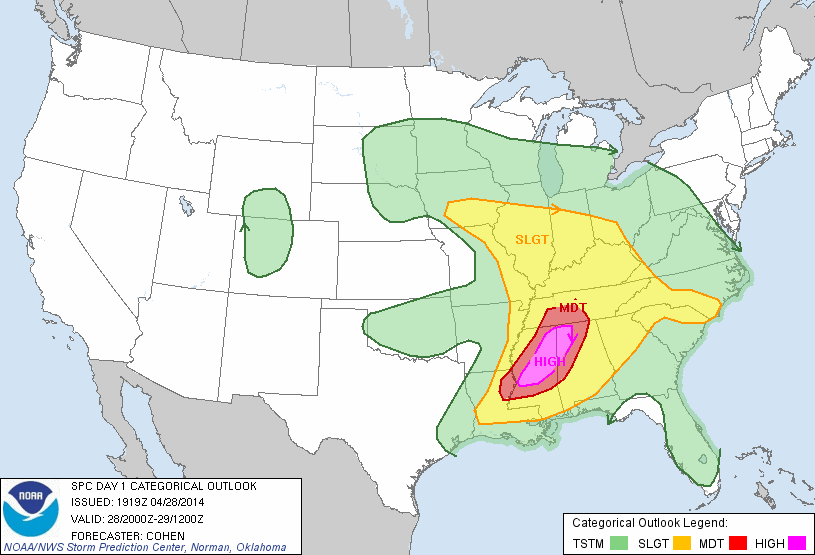
2014 | 4 | 29 | 0256 | Russell-Lee Storm Survey Event Information Event Information Event Overview Storm Information Damage Video Damage Video Moderate Risk |
F3 Polygon Warnings Tornado Watch |
11.45 | 1200 | 0 | 13 | 3 NW Crawford - 2 NE Smiths Station National Weather Service Meteorologists surveyed damage in northern Russell County and southern Lee County and determined that the damage is consistent with an EF-3 tornado, with maximum winds estimated to be around 140 mph. The tornado touched down one-tenth of a mile west of Flourney Road in Russell County, where several trees were snapped. It then traveled to the northeast, where it snapped and uprooted dozens of trees. The tornado crossed into Lee County, approximately three-tenths of a mile west of County Line Road. It continued to the northeast and strengthened to its maximum intensity near AL-169. At this location, approximately 6 manufactured homes were lifted, rolled, and completely destroyed. Additionally, a split level home had its roof and the exterior walls of the top floor removed. Three wood frame homes were also lifted off their foundation and completely destroyed. Several more homes sustained roof damage. Hundreds of trees were snapped off or were uprooted, with several trees debarked. From here, the tornado traveled northeast, where it continuously uprooted trees along its path. As it crossed lee County Road 205, one home suffered extensive roof damage, while approximately 20 additional homes sustained mainly shingle damage. The tornado crossed Lee County Road 179, where a few additional homes suffered minor roof damage as well. As it continue to the northeast, it began to weaken considerably and crossed US-280. A few trees were uprooted at this location. The tornado lifted along Lee County Road 298, approximately four-tenths of a mile from Lee County Road 318. Start: 32.4650/-85.2336 End: 32.5680/-85.0804 |
|
34
|
2014 | 4 | 29 | 0225 | Macon Storm Survey Event Information Event Information Event Overview Storm Information Moderate Risk |
F0 Polygon Warnings Tornado Watch |
1.74 | 75 | 0 | 0 | 1 SW Society Hill - 0.2 NESociety Hill National Weather Service meteorologists surveyed damage in northwestern Macon County and have determined that the damage is consistent with an EF-0 tornado, with maximum winds estimated to be 85 mph. The tornado touched down along Red Road, about six-tenths of a mile south of US-80. It traveled to the northeast, where several trees were snapped. As the tornado neared Highway 80, the Society Hill Methodist Church sustained minor roof damage. The tornado continued to the northeast, crossing Highway 80, where several trees were uprooted. The tornado lifted along County Road 43, about four-tenths of a mile north of US-80. Start: 32.4170/-85.4585 End: 32.4322/-85.4470 |
| 33 | 2014 | 4 | 29 | 0123 | DeKalb Storm Survey Event Information Storm Information Event Overview Moderate Risk |
F1 Polygon Warnings Tornado Watch |
1.05 | 200 | 0 | 0 | 3.7 ESE Fort Payne-4.4 E Fort Payne Damage was first noted just south of Bird Dog Trail at the southern end of a large farmstead. Numerous trees were snapped and uprooted and a large 40 FT by 50 FT barn was destroyed. This brief tornado appeared to be at its peak intensity near this location (100 mph winds). It should be noted that the barn damage was cleaned up at the time of the survey, but the homeowner confirmed the barn had totally collapsed. Several trees were snapped adjacent to the west side of a house which had no major damage. The short lived tornado moved northeast with additional trees snapped or uprooted just across Bird Dog Trail (north side). Two by fours and tin from the barn was seen here on the ground and in the trees. The homeowner also noted that tin from the barn was seen here on the ground and in the trees. The homeowner also noted that tin from the barn roof was tossed to at least the end of the tree line, which is approximately 1/3 of a mile away. The tornado then crossed a rural/forested area to the intersection of Pumpkin Center Road and CR 153/Fletcher Road. Small to medium sized branches were brought down at the southwest corner of this intersection. No additional damage was seen downstream from this location but very limited road access existed. Start: 34.4282/-85.6466 End: 34.4398/-85.6347 |
| 32 | 2014 | 4 | 29 | 0036 | DeKalb Storm Survey Event Information Event Overview Storm Information Moderate Risk |
F1 Polygon Warnings Tornado Watch |
10.20 | 200 | 0 | 0 | 5.2 SW Mentone-5.2 N Mentone A tornado touched down south of Mentone along the Desoto Parkway (CR 89) just south of the intersection with CR 165. Here, several large cedar trees were snapped. The tornado moved northeast, paralleling the western side of CR 165. Mainly tree damage was noted in this area, with minor structural damage to barns and outbuildings. Several stands of old growth hardwoods were damaged here. The tornado seemed to weaken briefly with only minor tree damage noted near downtown Mentone. Further up the slopes of Lookout Mountain, the tornado strengthened again to EF-1 intensity, with sporadic swaths of hardwood trees snapped or uprooted, all along the eastern side of CR 89, before lifting just inside the state line. Start: 34.5048/-85.6174 End: 34.6437/-85.5565 |
| 31 | 2014 | 4 | 29 | 0028 | DeKalb Storm Survey Event Information Event Overview Storm Information Moderate Risk |
F0 Polygon Warnings Tornado Watch |
2.42 | 75 | 0 | 0 | 5.4 NE Boaz-6.3 NNE Boaz A small tornado touched down in the Aroney community in the southwest corner of DeKalb County. The tornado first touched down along County Road 479. Here minor roof damage was noted to a single family home, and a farm building was also damaged. Minor damage was also noted to trees all along CR 479. Several small hardwood trees were snapped just north of CR 10, and other trees had the tops snapped off in this area. Another barn sustained minor roof damage further north along the road, and a home sustained very minor damage. The tornado eventually lifted just south of Highway 168 near the Kilpatrick Community. Start: 34.2243/-86.0781 End: 34.2589/-86.0843 |
|
30
|
2014 | 4 | 29 | 0017 | Etowah Storm Survey Event Information Event Information Event Overview Storm Information Moderate Risk |
F1 Polygon Warnings Tornado Watch |
6.28 | 200 | 0 | 0 | 2 W Rockledge - 1 NW Sardis City A short-lived tornado touched down along Egypt Road near Vaughn Lane snapping a few trees. The tornado tracked north-northeast and intensified near Shady Grove Road where a single-wide manufactured home was nearly destroyed. Near the intersection of Mountainboro Road and Carlisle Cut Off, a house was shifted off its foundation, but the house itself sustained only minor roof damage. A wood barn out in a field was heavily damaged. Just south of Lawson Gap Road, several trailers were damaged with one losing its roof and portion of its exterior walls. Trees were snapped or uprooted on the west side of Mountainboro Road. The tornado was at its peak intensity along Mountainboro Road between Shady Grove Road and Lawson Gap Road, with maximum winds between 90 and 100 mph. The tornado continued north approaching US-431. Additional damage occurred along Skyhaven Drive, where a two-story house lost a portion of its roof covering. Several trees were snapped or uprooted around this location as well. To the north, off Douglas Drive, a manufactured single-wide home lost most of its roof, its entire garage/car port and a good portion of one exterior wall. At the intersection Highway 205 and Highway 431, trees were snapped along the tornado path. This is where the tornado crossed Highway 431. Between Cox Gap Road and Gaines Street several large trees were snapped or uprooted and displayed a convergent path toward the center line of the tornado. The tornado crossed Sardis Road snapping a few trees near the intersection with Sardis Cut Off Road. Start: 34.0896/-86.1550 End: 34.1776/-86.1319 |
| 29 | 2014 | 4 | 29 | 0006 | DeKalb Storm Survey Event Information Event Overview Storm Information Moderate Risk |
F2 Polygon Warnings Tornado Watch |
11.71 | 200 | 0 | 0 | 5.8 NE Dawson- 4 NNW Fort Payne A previously tornadic cyclic supercell produced yet another tornado along County Road (CR) 209 where mainly branches were snapped. The tornado lifted northeast snapping additional branches before strengthening as it approached CR 52. Here, severe hardwood trees were snapped or uprooted near a farmstead. Additional trees were snapped and/or uprooted along a wide swath all along CR 88. The tornado may have weakened or even lifted very briefly as it crossed the Highway 35 intersection near Dugout Valley Road/CR 97 west-northwest of Fort Payne. The tornado intensified once again as it tracked northeast, uprooting and snapping more trees. The tornado reached peak intensity with estimated winds of 115 mph and a path width of 200 yards near the intersection with Chisenhall Road. At this location, the tornado rolled and separated a mobile home from its frame, peeled roofing back from another mobile home, and snapped many trees in a forested area just northeast of the intersection. It continued to track along CR 97, but weakened significantly, causing mostly tree damage or very minor structural damage to single family homes (two homes sustained minor roof damage or broken windows just north of the Chisenhall/CR 97 intersection). The tornado narrowed significantly before lifting along CR 609 just north of the intersection with CR 27. Start: 34.3491/-85.8401 End: 34.4958/-85.7372 |
| 28 | 2014 | 4 | 28 | 2354 | DeKalb Storm Survey Event Information Event Overview Storm Information Moderate Risk |
F2 Polygon Warnings Tornado Watch |
2.47 | 200 | 0 | 0 | 0.5 NW Dawson-1.6 NNE Dawson A tornado touched down in the community of Dawson along County Road 20. This would be the first of two tornadoes spawned by the same parent storm that produced the earlier Etowah-DeKalb County tornado. Numerous trees were snapped and/or uprooted in this area. The tornado tracked north-northeast snapping additional trees along County Road 199, and damaging a mobile home. Another home received minor structural damage along CR 196. The tornado fell a wide swath of trees before it crossed Highway 57. Here it reached maximum intensity, nearly destroying a small home. Several large farm buildings were significantly damaged near the intersection of CR 204 and 57. The tornado nearly paralleled the highway as it tracked further north. Another home sustained roof damage along CR 57 as well. The tornado began a weakening phase north of the intersection with CR 204, with mainly tree damage noted north of that location. The tornado finally lifted just north of the intersection of CR 57 and 109. Start: 34.3073/-85.9305 End: 34.3351/-85.9034 |
|
27
|
2014 | 4 | 28 | 2332 | Etowah-DeKalb Storm Survey Storm Survey 2 Event Information Event Information Storm Information Event Overview Damage Video Moderate Risk |
F3 Polygon Warnings Tornado Watch |
11.73 | 600 | 0 | 0 | 4 E Sardis City - 4 SE Crossville National Weather Service meteorologists surveyed damage in northern Etowah and DeKalb Counties and have determined that the damage is consistent with an EF-3 tornado with maximum winds estimated to be 155 mph. The tornado initially touched down just south of Brow Road, about 4 miles east of Sardis City, snapping and uprooting many trees. The tornado rapidly intensified as it tracked northeast and crossed Liberty Hill and Horton Gap Roads. Severe damage occurred along Liberty Hill Road where a home was lifted off its block foundation and moved about 60-80 feet from its original location. Despite this, most of the exterior walls (and even a portion of the roof) remained intact. Numerous trees around this property were snapped near the base indicating very strong winds. Just west of this location...Several manufactured homes/trailers were completely destroyed. Two other homes sustained significant roof loss and exterior wall damage. Along Horton Gap Road, a two-story home was destroyed with just a few interior walls left standing. Much of the debris was thrown several hundred yards away from its original location and trees were ripped out of the ground and thrown. Just northeast of this location, a large wood-framed chicken house was destroyed. At these locations, the tornado was at its peak intensity with winds estimated between 135 and 155 mph. On either side of the center line track, damage was seen along Owens Road (west of the track) and Roden Road (east of the track). Structural damage resulting in loss of roof and exterior walls/side panels was seen along with numerous trees snapped or uprooted. The tornado crossed very near where Roden and Owens roads intersect, just south of the Etowah/DeKalb County line. The tornado maintained EF-2 intensity/ as it crossed into DeKalb County. Start: 34.1703/-86.0439 End: 34.2679/-85.9453 |
|
26
|
2014 | 4 | 28 | 2324 | St. Clair-Blount Storm Survey Event Information Event Information Event Overview Storm Information Damage Video Damage Video Moderate Risk |
F2 Polygon Warnings Tornado Watch |
14.6 | 1300 | 0 | 2 | 4 WNW Springville - 4 WNW Horse Pens Forty National Weather Service meteorologists surveyed damage in extreme northwestern St. Clair County, eastern Blount County, and extreme western Etowah County and have determined that the damage is consistent with an EF-2 tornado. Maximum winds were estimated to be 130 mph. The tornado touched down just north of Mountain View Lane in extreme northwestern St. Clair County. The tornado strengthened as it moved to the northeast with some of the most extensive damage occurring just north of Pine Mountain Road. At this location, a home that was under construction but almost completely finished, was swept off its foundation and thrown about 50 yards into a lake. A small utility trailer was also thrown about 25 to 50 yards. Dozens of trees were either snapped or uprooted in this area as well. The tornado maintained its intensity as it moved northeast, snapping and uprooting thousands of trees. A single wide and double wide manufactured home were completely destroyed on Dumas Bridge Road, and at this location there were two injuries. The tornado continued northeastward and crossed Highland Lake. As the tornado crossed the lake, it was 1000 yards wide and mowed down forested areas, snapping or uprooting every tree in its path. On the shores of the lake, several homes received major damage directly from tornadic winds. On Echo Lane, a well-built single family home had its roof completely removed, while 2-by-6 exterior walls remained standing, and non-loadbearing walls were buckled. The neighboring home also had its roof torn off with some exterior walls collapsed. A three story home across the slough had major structural damage and was partially shifted off its foundation. The tornado continued to ravage the north shore of Highland Lake as it continued northeastward, snapping and uprooting more trees and damaging several more homes. The tornado seemed to weaken somewhat as it crossed County Road 29 with tree damage more sporadic than it had been. The tornado crossed Rogers Road and began a slight turn to the right as it weakened somewhat and damage became more sporadic. After the tornado crossed US-231, it began to narrow and weaken further before ending on Hutchins Drive near the Blount and Etowah County line. Start: 33.7993/-86.5395 End: 33.9473/-86.3652 |
| 25 | 2014 | 4 | 28 | 2315 | Clarke Storm Survey Event Overview Storm Information Slight Risk |
F1 Polygon Warnings Tornado Watch |
0.31 | 200 | 0 | 0 | 8.8 SSE Grove Hill The National Weather Service survey team found damage consistent with a small, short track, weak tornado over central Clarke County to the south-southeast of Grove Hill. Damage indicated that the tornado tracked from the west-southwest toward the east-northeast for approximately 500 yards. The damage initially began as a straight line wind event. The damage pattern then became more convergent, denoted by the downed and snapped tree pattern indicating a brief tornado. The damage then returned to a more linear non-tornadic pattern and the degree of damage gradually decreased across an additional two mile long path. Winds speeds associated with the tornado were estimated to range from 86 to 110 mph, resulting in numerous snapped and uprooted trees (both hardwood and softwood) and minor roof damage to two homes and a barn. Wind speeds diminished as the damage pattern became more linear. Start: 31.5759/-87.7633 End: 31.5776/-87.7585 |
|
24
|
2014 | 4 | 28 | 2222 | Blount Storm Survey Event Information Event Information Event Overview Storm Information Damage Video Damage Video Moderate Risk |
F1 Polygon Warnings Tornado Watch |
7.81 | 1000 | 0 | 0 | 3.9 SSW Oneonta - 4.75 ENE Oneonta National Weather Service meteorologists surveyed damage in eastern Blount County and have determined that the damage is consistent with an EF-1 tornado with maximum winds estimated to be 105 mph. The tornado touched down near the intersection of Boat Landing Road and Seven Mile Road, about 4 miles south-southwest of the city of Oneonta, where it damaged and uprooted several trees. From there it moved northeastward, practically paralleling the ridge of Straight Mountain for nearly 8 miles. It remained over largely rural areas for much of its path. It broadened to 1000 yards wide just after crossing US-231. Damage along US-231 consisted of mainly snapped pines and uprooted hardwoods. There was minor damage to a few homes and buildings in the area, although one chicken barn was heavily damaged. The tornado moved north-northeastward across Wadsworth Road and continued to cause widespread tree damage. It continued to slowly cross Airport Road diagonally, with continued tree damage and predominantly minor roof damage to homes and significant damage to outbuildings and hay barns. The only exception was a small older home that sustained significant damage. The tornado maintained its strength as it crossed County Road 20, Lowes Road, and finally Airport Road once again before dissipating rapidly at the airport. Start: 33.8908/-86.4871 End: 33.9705/-86.3934 |
|
23
|
2014 | 4 | 28 | 2216 | Jefferson Storm Survey Event Information Event Information Event Overview Storm Information Damage Video Video Moderate Risk |
F2 Polygon Warnings Tornado Watch |
5.14 | 600 | 0 | 0 | 2 WSW Bessemer - 3 NNE Bessemer National Weather Service meteorologists surveyed damage in Bessemer and have determined that the damage is consistent with an EF-2 tornado. Maximum winds were estimated to be 120 mph. The tornado touched down near Academy Drive. It then traveled to the northeast, snapping and uprooting dozens of trees along its path. In addition, dozens of homes had trees down on them just to the northeast of Academy Drive. The tornado intensified as it neared the Frank House Municipal Golf Course where the clubhouse was destroyed. The tornado continued on its northeast path, snapping and uprooting hundreds of trees. Several homes and an apartment complex experienced minor roof damage near Memorial Drive. The tornado continued to the northeast as it paralleled 4th Avenue North. Hundreds of trees were uprooted before it lifted near the intersection of Dartmouth Avenue and 32nd Street South. More details may be added later. Start: 33.3592/-86.9950 End: 33.4109/-86.9344 |
| 22 | 2014 | 4 | 28 | 2200 | Jefferson Storm Survey Event Information Event Information Event Overview Storm Information Moderate Risk |
F1 Polygon Warnings Tornado Watch |
7.62 | 913 | 0 | 0 | 4 SW North Johns - 5 NE North Johns National Weather Service meteorologists surveyed damage in central Jefferson County and have determined that the damage is consistent with an EF-1 tornado with maximum winds estimated to be 105 mph. The tornado touched down approximately three-tenths of a mile northeast of Alice Road. The tornado traveled to the northeast where it snapped and uprooted hundreds of trees along the path. It continued nearly parallel to Blue Creek Road and then traveled over private property where it continued to produce damage. The tornado neared Valley Creek and additional trees were snapped or uprooted. It continued on its northeast path and eventually crossed Johns Road where several trees were snapped. The tornado lifted approximately one-tenth of a mile northeast of Sunnyhill Drive. A special thanks to Frank Earnest for his assistance in completing this survey. Start: 33.3162/-87.1110 End: 33.4009/-87.0313 |
| 21 | 2014 | 4 | 28 | 2155 | Tuscaloosa-Jefferson Storm Survey Event Information Event Information Event Overview Storm Information Moderate Risk |
F1 Polygon Warnings Tornado Watch |
4.46 | 675 | 0 | 0 | 2 NE East Brookwood - 2 NW Weller National Weather Service meteorologists surveyed damage in northern Tuscaloosa County and eastern Jefferson County and have determined that the damage is consistent with an EF-1 tornado. The tornado touched down approximately two-tenths of a mile north of Milldale Road. It then traveled to the northeast where it snapped and uprooted trees. The tornado crossed Griffen Ridge Road, Ridge Road and then Weller Road where trees were uprooted along each road. The tornado crossed into Jefferson County approximately three-quarters of a mile north of Weller road and continued to produce minor tree damage. It lifted just inside the Jefferson County line, approximately one mile east of Sealy Ann Mountain Road. Start: 33.3129/-87.2197 End: 33.3587/-87.1667 |
| 20 | 2014 | 4 | 28 | 2113 | Jefferson Storm Survey Event Information Event Information Event Overview Storm Information Damage Video Damage Video Moderate Risk |
F2 Polygon Warnings Tornado Watch |
5.46 | 1800 | 0 | 3 | 3 SSW Adamsville - 0.7 W Brookside National Weather Service Meteorologists surveyed damage in central Jefferson County and have determined that the damage is consistent with an EF-2 tornado. Maximum winds were estimated to be 125 mph. The tornado touched down near Oak Leaf Circle. It then traveled to the northeast where it snapped and uprooted dozens of trees along its path. The tornado intensified as it neared Cruce Road just south of Graysville. Here, approximately four manufactured homes sustained major damage with one being completely destroyed after it rolled several times. The tornado continued on its northeast path and snapped and uprooted hundreds of trees. As it neared Adamsville Parkway, two brick homes sustained damage from partial exterior wall collapse. Additionally, another manufactured home sustained damage. The tornado took a slight right turn as it crossed Interstate 22 near Cherry Avenue before it lifted along Brookside Cardiff Road near McCay Road. Start: 33.5856/-87.0055 End: 33.6284/-86.9323 |
| 19 | 2014 | 4 | 28 | 2100 | Jefferson-Blount Storm Survey Event Information Event Information Event Overview Storm Information Damage Video Damage Video Moderate Risk |
F1 Polygon Warnings Tornado Watch |
8.78 | 800 | 0 | 4 | 0.6 W Morris - 1.1 SSE Hayden National Weather Service meteorologists surveyed damage in northern Jefferson County and have determined that the damage is consistent with an EF-1 tornado. Winds were estimated to be around 100 mph. The tornado touched down near Interstate 65, about one-half mile south of Sardis Road. The tornado moved to the northeast and crossed Interstate 65, where it snapped and uprooted hundreds of trees along the path. As the tornado continued to the northeast and moved into the city limits of Kimberly, several structures were damaged. In Kimberly, a vacant large retail building had its roof removed. The most extensive damage occurred to the Kimberly Church of God where uplift of most of the roof structure resulted in exterior wall collapse. The tornado crossed Stouts Road where the Kimberly Fire Department sustained major damage.The tornado continued to snap dozens of trees as it moved northeast and several homes had shingle damage. As the tornado crossed Bradford Trafford road, multiple trees were uprooted with one falling on a home causing major roof damage. It began to weaken as it crossed into Blount County, where sporadic tree damage was observed. It lifted near Sagefield Lane. Start: 33.7514/-86.8303 End: 33.8640/-86.7644 |
| 18 | 2014 | 4 | 28 | 2059 | Tuscaloosa Storm Survey Event Information Event Information Event Overview Storm Information Damage Video Moderate Risk |
F1 Polygon Warnings Tornado Watch |
12.47 | 1500 | 0 | 13 | 1.2 NW Hull - 1.7 S Cottondale National Weather Service meteorologists surveyed damage in southern Tuscaloosa County and have determined that the damage is consistent with an EF-1 tornado. Winds were estimated to be around 100 mph. The tornado initially touched down on the north side of Phares Hinton Road, about one-half mile west of Highway 69. The tornado moved north-northeast, where it snapped and uprooted hundreds of trees and caused minor shingle damage to numerous homes as it moved through several subdivisions. As the tornado continued north and eastward, the tornado crossed Old Greensboro Road where it uprooted and snapped the trunks of numerous large, old hardwoods at the Little Sandy Baptist Church. The tornado then continued northeast across Highway 69, where it downed multiple trees on the east side of the highway. The tornado then took on a more easterly movement and produced sporadic tree damage until it reached the Taylorwood Estates subdivision and the Bear Creek trailer park. In this area, the tornado snapped or uprooted hundreds of trees. The tornado then moved east-northeast and caused sporadic tree damage as it crossed Highway 82 and continued across Hargrove Road. Just west of Hargrove Road, the tornado again uprooted and snapped numerous hardwood and softwood trees and caused major damage to about 25 mobile homes as trees fell on the homes. One small porch was ripped from a double wide mobile home. The tornado then moved through the Woodland Forest subdivision where it uprooted and snapped hundreds of more trees. As the tornado approached Buttermilk Road, the southerly winds got under the soffit of a single family home and ripped out a small portion of the roof. The tornado caused minor roof damage and uprooted several trees on the east side Buttermilk Road before it finally lifted. This tornado was very close to the path of the F4 tornado back in 2000. Start: 33.0625/-87.6345 End: 33.1559/-87.4513 |
| 17 | 2014 | 4 | 28 | 2030 | Sumter Storm Survey Event Information Event Information Event Overview Storm Information Moderate Risk |
F1 Polygon Warnings Tornado Watch |
1.03 | 150 | 0 | 0 | 5 SSE York - 4 SE York A short-lived tornado touched down in a wooded area near W.L. Ezell Road in the Siloam Community. The tornado traveled to the northeast, crossing AL-17 and dissipated just south of U.S. Highway 80. Damage was consistent with an EF-1 tornado with winds of 100 mph. Along W.L. Ezell Road and County Road 9, two well-built homes received significant roof and other structural damage. Nine other homes received roof damage, and several outbuildings were destroyed. A convenience store received significant damage to the roof and primary structure, and the fuel awning was destroyed. Additionally, a local fire station received significant damage to one of its buildings and minor damage to another. Along the path numerous trees were snapped and uprooted. A special thanks to Chief Vaughan of the Cuba Fire Department for completing this survey. Start: 32.4208/-88.2710 End: 32.4331/-88.2611 |
| 16 | 2014 | 4 | 28 | 1940 | Walker Storm Survey Event Information Event Information Event Overview Storm Information Moderate Risk |
F1 Polygon Warnings Tornado Watch |
2.39 | 150 | 0 | 0 | 1 SW Boldo - 1 NE Boldo National Weather Service meteorologists surveyed damage in northeastern Walker County and have determined that the damage is consistent with an EF-1 tornado with maximum winds of 90 mph. The tornado touched down just south of Richardson Road, in the Boldo Community, where a couple of trees were uprooted. The tornado traveled toward the northeast where it uprooted several trees as it crossed Golf Course Road and South Pine Drive. The tornado strengthened as it crossed Boldo Road where several trees were snapped and uprooted and minor shingle damage occurred to a house. The tornado then crossed AL-69 as it uprooted a couple of trees and caused minor damage to a church. The tornado continued to the northeast and continued to uproot trees and cause minor shingle damage to another home before it lifted along Robinson Road just north of AL-69. Start: 33.8344/-87.1945 End: 33.8617/-87.1719 |
| 15 | 2014 | 4 | 28 | 1939 | Cullman Storm Survey Event Information Event Overview Storm Information Moderate Risk |
F3 Polygon Warnings Tornado Watch |
8.88 | 350 | 0 | 0 | Welti - Berlin A tornado first touched down in the Welti community along CR 636. Numerous hardwood trees were snapped and uprooted in this area. The tornado continued to move north with significant damage to a one story home along CR 601. Major roof uplift was noted to this home and a building under construction at the same site was completely destroyed and blown several hundred yards. A large travel trailer was also rolled. Damage at this location was deemed EF-2 in intensity. Further north along the road a large outbuilding was completely destroyed.The tornado intensified as it moved northward crossing the Broglen River. Here the tornado widens to near 350 yards. Many hardwood trees were snapped and uprooted along the path. A chicken farm sustained damage along CR 732. Near this location along CR 736 a well constructed two story brick home sustained severe damage when the upstairs was completely wiped away and blown several hundred yards into a ravine. The occupants of the home were interviewed and stated they received the warning and sheltered safely in their basement. Large debris missiles were seen embedded in the surrounding fields. Several trees in this area were also severely mangled and partially debarked. Damage in this area was rated low end EF-3. The tornado continued to track northward ripping the roof completely off a home at the intersection of CR 736 and 703. The tornado intensity oscillated as it tracked northward toward the Berlin community. Numerous wooden power poles were snapped along CR 703. Numerous trees were snapped or uprooted as it crossed Highway 278 with some trees sheared near the base. A TVA substation suffered significant damage with large electrical lines damaged and poles snapped and destroyed. The survey team was not able to fully observe this damage due to security restrictions but online photos indicate that this particular damage is consistent with at least high end EF-2 or possibly EF-3 damage. A chicken farm sustained severe structural damage with one house completely wiped to the ground with the metal trusses severely mangled. 25,000 chickens were killed in this one location. A mobile home along CR 747 was completely destroyed with debris thrown over 50 yards. Additional tree damage was noted in this area. The tornado weakened quite rapidly after this point lifting just north of Hwy 69. Start: 34.0957/-86.7598 End: 34.2233/-86.7407 |
| 14 | 2014 | 4 | 28 | 1918 | Jackson-DeKalb Storm Survey Event Information Event Overview Storm Information Moderate Risk |
F1 Polygon Warnings Tornado Watch |
6.13 | 100 | 0 | 0 | 4 SW Shiloh - 1 NE Higdon A tornado touched down along County Road (CR) 326 in extreme eastern Jackson County, just south of the CR 324. It tracked northeast into extreme northern DeKalb County just south of Higdon, Alabama. Most of the damage observed was to trees...with multiple trees uprooted or snapped along the tornado path. The most significant damage occurred along CR 155 in DeKalb County near the intersection of CR 823. In this area, minor roof damage and underpinning damage was observed at several mobile homes. One single family house along CR 155 sustained more significant roof, carport, and siding damage. The tornado continued to move northeast, causing additional damage to homes, outbuildings, and one church. The tornado lifted along the Jackson/Dekalb County line just before reaching the Georgia state line. Start: 34.7945/-85.6557 End: 34.8604/-85.5835 |
| 13 | 2014 | 4 | 28 | 1835 | Fayette-Marion Storm Survey Event Information Event Information Event Overview Storm Information Moderate Risk |
F1 Polygon Warnings Tornado Watch |
6.97 | 350 | 0 | 0 | 3 SE Glen Allen - 5 NW Eldridge National Weather Service meteorologists surveyed damage in northeastern Fayette County and southeast Marion County and have determined that the damage is consistent with an EF-1 tornado. Maximum winds were estimated to be 100 mph. The tornado touched down near the intersection of County Road 73 and County Road 53 where 5 to 10 trees were either snapped or uprooted with some minor roof damage to a home. The tornado then crossed County Road 65 near Eldridge Road where a couple of outbuildings lost portions of their roof. The tornado intensified as it crossed County Road 53 near the intersection of Eldridge Road. Here a couple of outbuildings were near total losses, dozens of trees were blown down, and a residence sustained minor damage. The tornado weakened as it moved to the north and east, and it lifted near the intersection of County Road 30 and Ramsoar Hollow Road. Start: 33.8878/-87.7094 End: 33.9842/-87.6763 |
| 12 | 2014 | 4 | 28 | 1754 | Pickens Storm Survey Event Information Event Information Event Overview Storm Information MS Survey Video Video Moderate Risk Started in MS |
F2 (F2) Polygon Warnings Tornado Watch |
6.21 (14.27) |
500 (500) |
0 (0) |
5 (5) |
6 NW Ethelsville - 5 W Shaw A National Weather Service storm survey team investigated damage in northern Pickens County and determined it was consistent with an EF-2 tornado. This tornado originated in Lowndes County, Mississippi and continued into northern Pickens County for several miles. As the tornado entered Pickens County along County Road 30, multiple structures were damaged including several mobile homes and several site-built homes. The worst damage occurred along County Road 30 as a site-built home shifted off its foundation and trapped 10 people in the basement. All of them survived, but 5 people were transported to a local hospital with minor injuries. County Road 30 also had several mobile homes that were completely destroyed along with one small concrete building that had its roof removed and one exterior wall completely destroyed. The tornado continued northeast across Highway 82 and began to weaken along Baines Road where several roofs sustained minor damage and several trees were uprooted. The tornado then rapidly dissipated near Tabernacle Road where only sporadic damage was found. It is also noteworthy that several damage points south of the tornado track were consistent with straight-line winds. Start: 33.4888/-88.2802 End: 33.5107/-88.1759 |
| 11 | 2014 | 4 | 28 | 1722 | Lamar Storm Survey Event Information Event Information Event Overview Storm Information MS Survey Moderate Risk Started in MS |
F1 |
8.08 (10.03) |
500 (500) |
0 (0) |
0 (0) |
8.3 W Fernbank - 2.3 NNW Fernbank A National Weather Service storm survey team investigated damage in southern Lamar County and determined it was consistent with an EF-1 tornado. This tornado originated in Lowndes County, Mississippi and continued into southern Lamar County for several miles. As the tornado entered Lamar County along State Road 96, dozens of trees were snapped and uprooted. The tornado then moved through the Lacey Brooke Community where several well-built homes sustained minor roof and exterior damage. The tornado traveled east-northeast nearly parallel to State Road 96 and continued to cause tree damage all the way to Fernbank Road. The tornado dissipated near the intersection of Fernbank Road and Mud Creek Road where only small limbs were damaged. Start: 33.5379/-88.2741 End: 33.5785/-88.1516 |
| 10 | 2014 | 4 | 28 | 1650 | Madison Storm Survey Event Information Event Overview Storm Information Damage Video Video Moderate Risk |
F1 Polygon Warnings Tornado Watch |
8.91 | 100 | 0 | 0 | 4 NW Hazelgreen - 5 NE Hazelgreen A tornado touched down along Charity Lane between Stafford and Butter-and-Egg Roads. It tracked almost directly eastward along Charity Lane, snapping and uprooting hundreds of trees and causing minor roof damage to multiple houses. At Charity Baptist Church, the tornado uprooted a very large oak tree believed to be around 150 years old. It began tracking more to the northeast as it reached Frank Patterson road, continuing to snap many more trees in the Hazel Trace and Hazelwood Drive area. It crossed Highway 231/431, collapsing a carport near Carriger Road. The tornado continued to snap and uproot many more trees along Mulberry Road, Bevills Church Road, Greenville Pike, and Everett Jones Road. The tornado dissipated just east of Everett Jones Road, just south of Borderline Road and the Tennessee State Line. Note: damage noted to a convenience store along highway 231/431 near the Bobo Section Road intersection was determined to be straight line wind damage associated with the tornadic storm. Based on the construction of the store, wind speeds were estimated at 75-80 mph. Start: 34.9476/-86.6465 End: 34.9868/-86.4965 |
| 9 | 2014 | 4 | 28 | 1638 | Marion Storm Survey Event Information Event Information Event Overview Video Storm Information Moderate Risk |
F0 Polygon Warnings Tornado Watch |
7.72 | 100 | 0 | 0 | 3 NNW Hamilton - 9.25 NE Hamilton A National Weather Service storm survey team investigated damage in Marion County and determined it was consistent with an EF-0 tornado. This tornado touched down near the intersection of County Road 75 and Bishop Road, in a rural area northwest of the city of Hamilton. It remained in a largely rural area as it travelled about 7.6 miles northeastward across the middle of Marion County between the cities of Hamilton and Hackleburg. Damage was primarily confined to uprooted trees and branches that were snapped off. One building on County Road 29 had some shingles blow off and a shed in the same area was damaged. After crossing Highway 187, the tornado lifted along Highway 43 just before it reached the Hackleburg city limits. Start: 34.1854/-87.9980 End: 34.2460/-87.8874 |
| 8 | 2014 | 4 | 28 | 1547 | Limestone Storm Survey Event Information Event Overview Storm Information Video Damage Video Damage Video Moderate Risk |
F3 Polygon Warnings Tornado Watch |
15.56 | 600 | 2 | 30 | 5 SE Rogersville - 2 N Athens A tornado rapidly intensified near Wheeler Lake At the intersection of Lawrence, Lauderdale, and Limestone County around 4:47 pm CDT, Monday April 28th resulting in extensive damage across southwest Limestone County. Significant damage occurred at the Bay Hill Marina in Limestone County where a 2-story condominium was destroyed and a large metal Building structure (used to store boats) sustained nearly complete failure of its exterior frame. Additional residences and condos had roof and exterior wall/siding damage and numerous large trees were snapped or uprooted. Several docks with metal protective coverings were destroyed. The tornado was near its peak intensity across this area, with winds between 120 and 140 mph. The tornado continued east-northeast snapping numerous power poles near their bases along Snake Road. Along Log Cabin Road, just South of Highway 72, several homes sustained significant (if not complete) roof loss along with partial collapse of exterior walls. One single-family residence slid several feet off its concrete slab foundation. A trailer was also completely destroyed. The tornado maintained high-end EF-2/low-end EF-3 strength as it crushed Billy Barb`s Trailer Park on highway 72 in the Coxey community. 25 units were completely destroyed or uninhabitable. Two confirmed fatalities occurred at this location, with at least a dozen others injured. Debris was thrown across highway 72 near Gordon/New Cut Road. The tornado crossed Highway 72 entering a mainly rural area of Limestone County. Numerous trees were snapped or uprooted on either side of Highway 72 between Blue Springs Road and Parker Road. The last significant area of damage occurred at a neighborhood community near the intersection of Seven Mile Post and Guinn Road. At this 10-acre location, nearly ever home (concrete masonry unit) sustained some damage with at least a half dozen destroyed. One unit was swept clean off its foundation but was not anchored/secured to its foundation. The tornado continued east-northeast producing mainly EF-0 and EF-1 damage, minor roof/siding damage and snapped or uprooted trees, before gradually lifting just north of Athens near the intersection of West Elm Street and North Jefferson Street. It should be noted that sporadic damage (mainly trees snapped or uprooted) was seen extending at least 1/2 to 1 mile on either side of the center track of this tornado. This damage was not included in the path width. Other notes, two more supercells crossed nearly the same areas following this tornado. Additional brief tornadoes could have occurred very close to this damage path. Further assessment may be needed as time allows. The start/end points of this track could also be adjusted pending further storm damage information. Appreciation to the Limestone County Emergency Management Agency for their assistance in conducting this storm survey. Start: 34.7753/-87.2324 End: 34.8184/-86.9633 |
| 7 | 2014 | 4 | 28 | 1456 | Franklin Storm Survey Event Information Event Overview Storm Information Video Moderate Risk |
F1 Polygon Warnings Tornado Watch |
3.19 | 100 | 0 | 0 | NW Russellville - NE Russellville A tornado first touched down along Whitten Road near the intersection of Willis Road on the northwest side of Russellville. Trees were uprooted in this area and small trees were snapped. The tornado tracked northeast approaching the school complex. Here a tree was snapped and fell onto a house along Clay Avenue causing significant structural damage. The school complex along Summit Avenue sustained damage to its athletic fields and one awning at the elementary school was damaged. Across the street several trees were snapped near the base and a home sustained minor roof damage. The tornado then appeared to weaken briefly with only very light damage noted over the next 2 miles before touching back down near Alpine Street. Here numerous hardwoods were twisted, mangled, and snapped. Several trees fell on houses causing substantial structural damage. The tornado reached its maximum intensity of EF-1 with a width of approximately 100 yards. Interviews with several residents indicated that they observed a multiple funnel type of tornado track across the neighborhood. The tornado lifted northeast and weakened as it produced minor tree damage along Mountain View Drive before dissipating. Start: 34.5219/-87.7494 End: 34.5480/-87.7032 |
| 6 | 2014 | 2 | 21 | 0156 | St. Clair Storm Survey Event Information Moderate Risk |
F0 Polygon Warnings Tornado Watch |
4.2 | 150 | 0 | 0 | 0.5 E Sanie - 0.7 S Odenville A tornado touched down near Jamaica Lane, west southwest of Branchville, causing minor roof damage to a mobile home and uprooting several small trees. The tornado tracked northeastward and strengthened, with winds of 85 mph, as it neared the intersection of Sanie Road and Nelsie Ann Drive. Six to eight two-story homes sustained minor roof damage as well as 30-50 trees uprooted or snapped. The tornado caused similar damage along Hurst Drive, where 25-40 trees were either snapped or uprooted and a two-story home and barn sustained minor roof damage. The tornado made a turn to the north northeast and tracked parallel to Anderson Mountain, downing trees as it crossed Copper Springs Rd near Dogwood Cir. The tornado turned to the east and continued downing trees as it crossed Shadow Bend Dr and U.S. Highway 411. The tornado track narrowed as it crossed Hwy 411 and Alabama Highway 174. The tornado downed 10-20 trees along Tucker Rd, with one down on a home. The tornado lifted just east of Tucker Road, 0.40 miles north of the intersection of Tucker Rd and Oak Ridge Dr. In addition, there was sporadic damage near the beginning and ending of this tornado path as a result of straight line winds associated with the same thunderstorm. Start: 33.6512/-86.4678 End: 33.6703/-86.4014 |
| 5 | 2014 | 2 | 21 | 0028 | DeKalb Storm Survey Event Information Event Information Moderate Risk |
F2 Polygon Warnings Tornado Watch |
0.83 | 50 | 0 | 1 | 4 NNE Fort Payne - 5 NE Fort Payne A brief but strong tornado with wind speeds up to 125 mph touched down at the Jet Polymer Plant off of Gault Avenue about 4 miles north-northeast of the town of Fort Payne in central DeKalb County. The tornado flipped 3 large tractor trailers, one of which was vaulted into the air, landing on top of the plant's roof. Adjacent to the plant, across a parking lot, a medium sized metal building structure had much of its metal siding removed and roof uplifted. Also, the column anchorage was severely bent and failed. The tornado continued its track northeast, snapping and uprooting medium to large trees. Beyond this point, the tornado appeared to skip along its track (little to no damage seen), before doing significant structural damage to several homes along Green Valley Circle. One person experienced minor injuries (lacerations) at one of the homes in this location. Two single-family well constructed residences sustained a complete loss of roof material and a collapse of at least two exterior walls (mainly around the garage areas). Numerous trees surrounding the properties were snapped or uprooted. In addition, one small and one medium sized shed were completely destroyed. This area appeared to be where the tornado was at its strongest. Other nearby homes in the neighborhood along Green Valley Circle sustained mainly loss of roof shingles, siding panels, and broken windows. Just up the hill from this location, a small apartment complex was hit. Partial uplift of the roof occurred at this location. Also nearby, a small apartment complex was hit, where partial uplift of the roof, loss of siding, and broken windows were seen at this two story apartment complex. Other smaller buildings had just minor roof damage, with small trees snapped off, and small branches broken off of trees. The tornado continued northeast along its short track and appeared to quickly weaken and eventually lift near the intersection of 55th Street and Martin Avenue, but not before causing partial roof loss to a home. At this location, plastic fencing around a pool was knocked out and several trees were snapped about halfway down. Debris was also noticed littering the area, seemingly deposited by the tornado as it diminished. Start: 34.4941/-85.6754 End: 34.4994/-85.6624 |
| 4 | 2014 | 2 | 20 | 2105 | Limestone Storm Survey Event Information Event Information Moderate Risk |
F1 Polygon Warnings Tornado Watch |
2.73 | 500 | 0 | 0 | 0.5 E Gipsy - 1.1 N Cross Key A tornado touched down along Section Line Road just east of Highway 99 in the Cartwright Community. Initially the tornado was relatively weak snapping small limbs on softwood trees along Harris Loop Road. Power poles were also were also snapped in this location. Estimated winds in this area were roughly 100 mph. A home along Section Line Road also received minor roof uplift and loss of shingles. As the tornado continued to move east-northeast, additional tree damage was noted along Easter Ferry Road and Davis Lane. The tornado apparently lifted along the hilltops just west of Witty Mills Road. Start: 34.8798-87.0707 End: 34.8865/-87.0233 |
| 3 | 2014 | 2 | 20 | 2055 | Lauderdale Storm Survey Event Information Event Information Moderate Risk |
F1 Polygon Warnings Tornado Watch |
2.67 | 500 | 0 | 1 | 1.8 SSW Anderson - 1.8 E Anderson A tornado touched down in the Anderson Community of eastern Lauderdale County Thursday morning. The tornado first touched down along Highway 207 south of CR 86. Multiple hardwood trees were uprooted and snapped here. In addition at least one power pole was snapped at the base. The tornado moved northeast crossing Highway 207 onto CR 86. Here several well built homes sustained minor to moderate roof damage with significant uplift of at least one roof structure. A child suffered minor injuries in one of the homes. The tornado reached its maximum intensity of approximately 105 mph here. The tornado crossed Hudson Avenue, snapping additional trees and producing minor damage to one home. Sporadic tree damage was also noted along CR 95 and CR 52 before the tornado lifted just east of CR 530. Start: 34.8950/-87.2783 End: 34.9160/-87.2387 |
| 2 | 2014 | 2 | 20 | 2051 | Lauderdale Storm Survey Event Information Event Information Moderate Risk |
F1 Polygon Warnings Tornado Watch |
1.82 | 400 | 0 | 0 | 2.6 NNW Wheeler Lake South - 2.0 NNW Rogersville An EF-1 tornado with wind speeds up to 105 mph touched down in the Ramblewood subdivision on the south side of Rogersville. Along Ramblewood Drive, many very large hardwood and softwood trees were uprooted. Several hardwood trees were snapped near the base. At least two utility poles were snapped in this location. Several homes sustained minor roof damage with the loss of shingles, siding, or gutters. The tornado may have touched down south of this location but it was unclear at the time of the survey. The tornado then moved northeast over forested and rural terrain, finally crossing near the intersection of Lambs Ferry Road and CR 608. Here, a few very small trees were snapped. The tornado moved to the northeast, snapping a few tree branches and crossing Lambs Ferry Road before lifting south of Fuqua Lane. Start: 34.7858-87.3149 End: 34.8021/-87.2899 |
| 1 | 2014 | 2 | 20 | 2045 | Lawrence-Limestone Storm Survey Event Information Event Information Video in Coxey, Al Moderate Risk |
F1 Polygon Warnings Tornado Watch |
10.72 | 450 | 0 | 0 | 1.8 WSW Pointer Quarters - 1.2 WSW Wheeler Lake North A tornado touched down along County Road 388 in northern Lawrence County. Here, large limbs were broken as the tornado was initially weak and disorganized. The tornado began to strengthen as it lifted northeast and crossed County Road 400. Here, a swath of hardwood trees were uprooted with a few trees snapped. The tornado then crossed the Tennessee River into Limestone County. The tornado tracked across the Tennessee River from Lawrence County at Bay Hill Drive at the marina on the northern end of the Tennessee River in Limestone County. The marina sustained minor damage and several of the condos and homes here had minor structural damage and several of the condos and homes here had minor structural damage. Trees were snapped and uprooted here as well. Utility poles were snapped along Snake Road as the tornado strengthened to EF-1 intensity with wind speeds up to 105 mph. The tornado moved northeast and snapped multiple trees as it crossed Wright Road. Utility poles were also snapped here. The peak wind was estimated at 105 mph. A manufactured home was damaged along Wright Road just south of Highway 72 and a utility building was also destroyed. Clements High School sustained minor damage to athletic fields. Homes sustained minor damage along Allison Loop Road and Cox Road, mainly minor roof uplift and loss of shingles). The tornado continued to move northeast and crossed Blue Springs Road. A large number of hardwood trees were snapped at the base here and power poles were also snapped near the ground. Several homes sustained damage when the trees fell on top of the homes. A car was also crunched in this location. The tornado then crossed the Elk River as it uprooted trees along Curtis Road. The tornado then apparently lifted. Start: 34.6889/-87.2589 End: 34.8223/-87.1687 |

