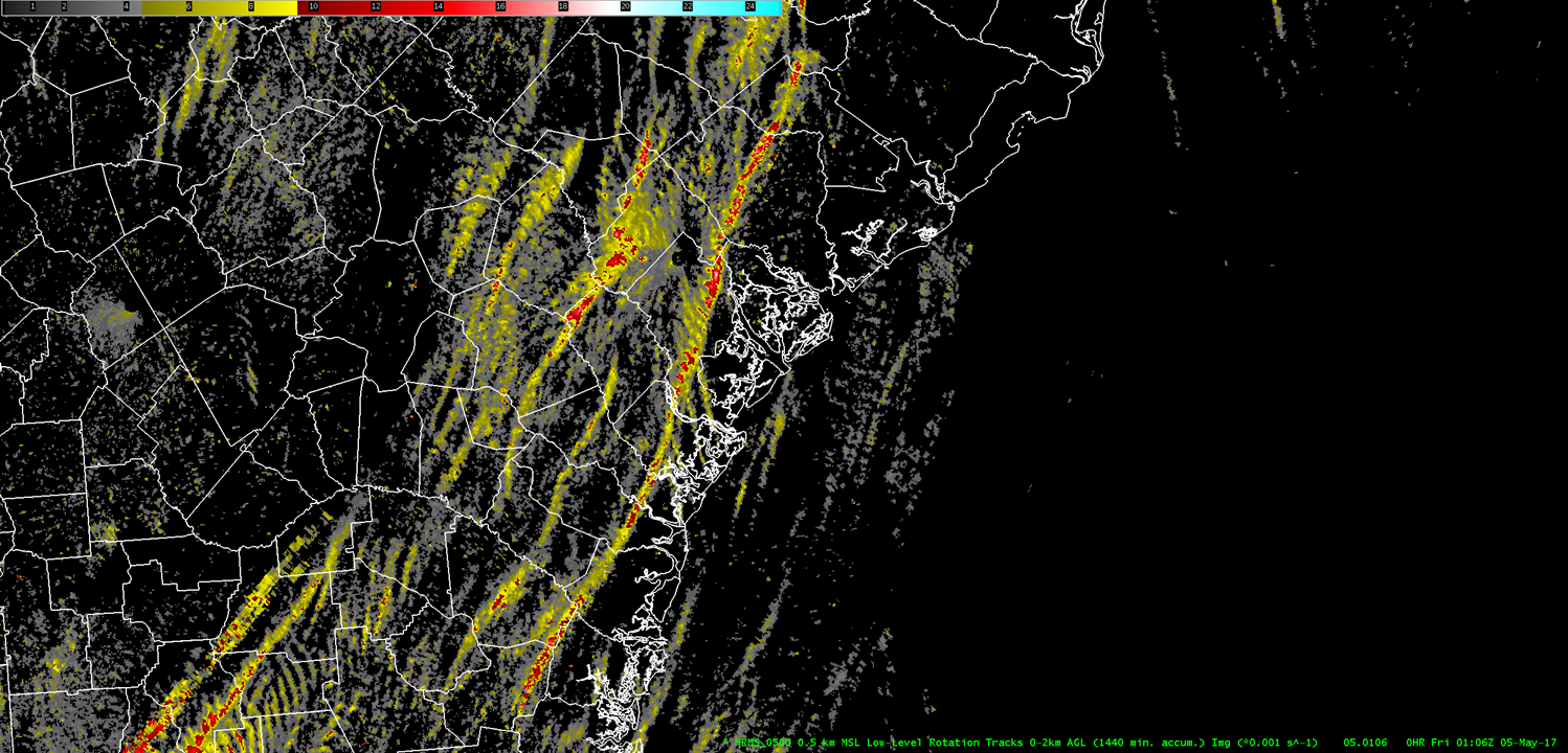
Thunderstorms developed south of a warm front and ahead of a cold front in an environment characterized by high shear, low Lifted Condensation Levels (LCLs), and low levels of instability, which is favorable for tornadoes. In fact, NWS Charleston confirmed four tornadoes; one in Chatham County, GA, two in Colleton County, SC and one in Colleton and Dorchester Counties in SC. The image below shows the Multi-Radar Multi-Sensor (MRMS) low-level rotational tracks indicating the track of the strongest low-level rotations, including from the supercell that produced the tornadoes from Chatham County, GA northward into Dorchester County, SC.
Graphics
Click on images to enlarge
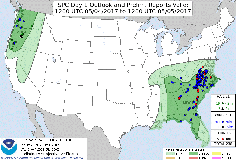
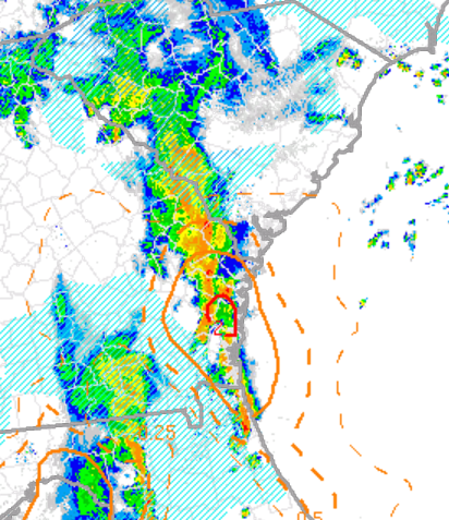
Top-Left: NWS Storm Prediction Center (SPC) Day One Convective Outlook (issued May 4 @ 103 AM EDT) and storm reports
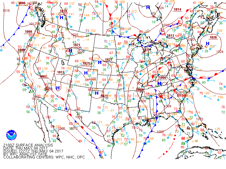
Top-Right: NWS Weather Prediction Center (WPC) surface analysis at 5 pm EDT on May 4
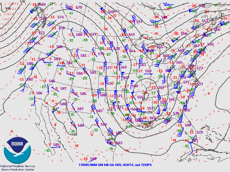
Bottom-Left: NWS SPC 500-mb analysis at 8 pm EDT on May 4
Bottom-Right: NWS SPC analysis of Effective Significant Tornado Parameter at 5 pm EDT on May 4
Click on images to enlarge
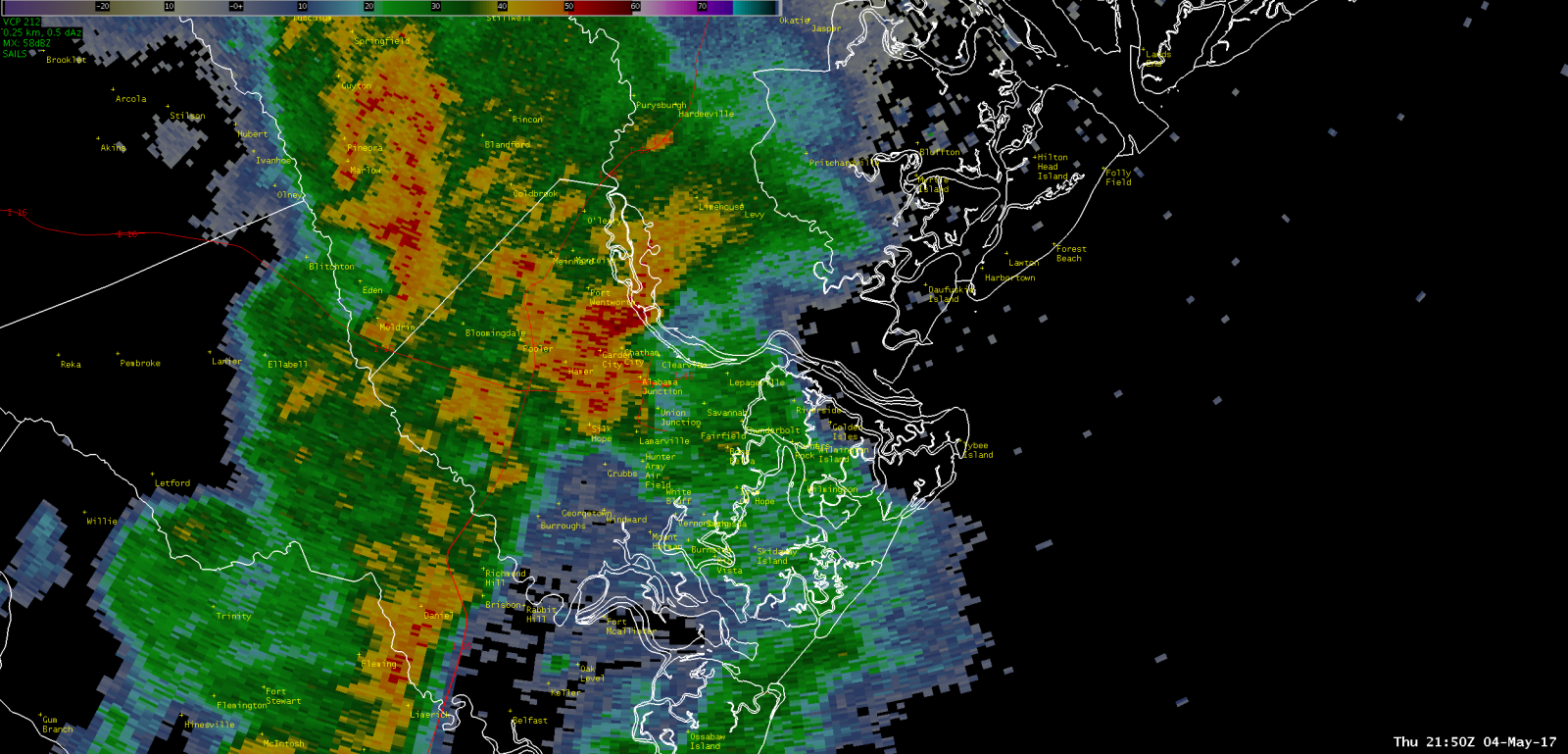
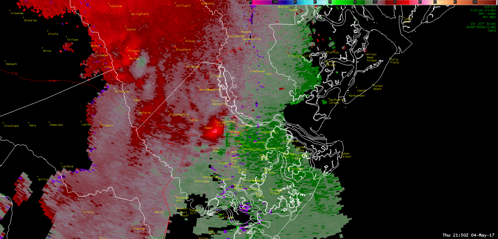
| Chatham County, GA (Garden City) | ||
|
KCLX Base (0.5 Degree) Reflectivity (May 4, 2017 - 550 PM EDT) |
KCLX Base (0.5 Degree) Storm-relative Velocity (May 4, 2017 - 550 PM EDT) |
|
|
|
|
|
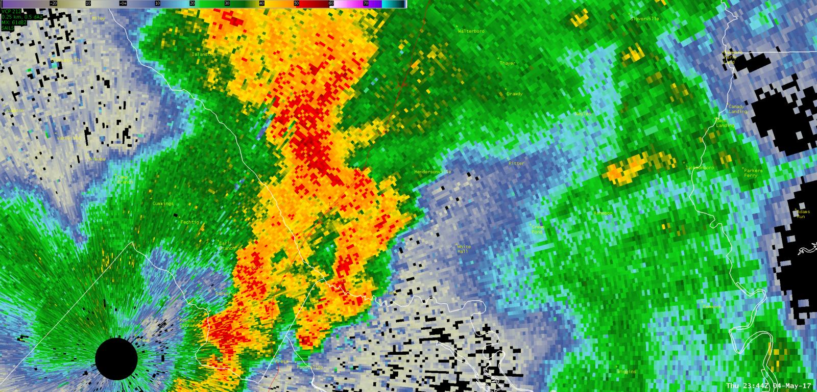
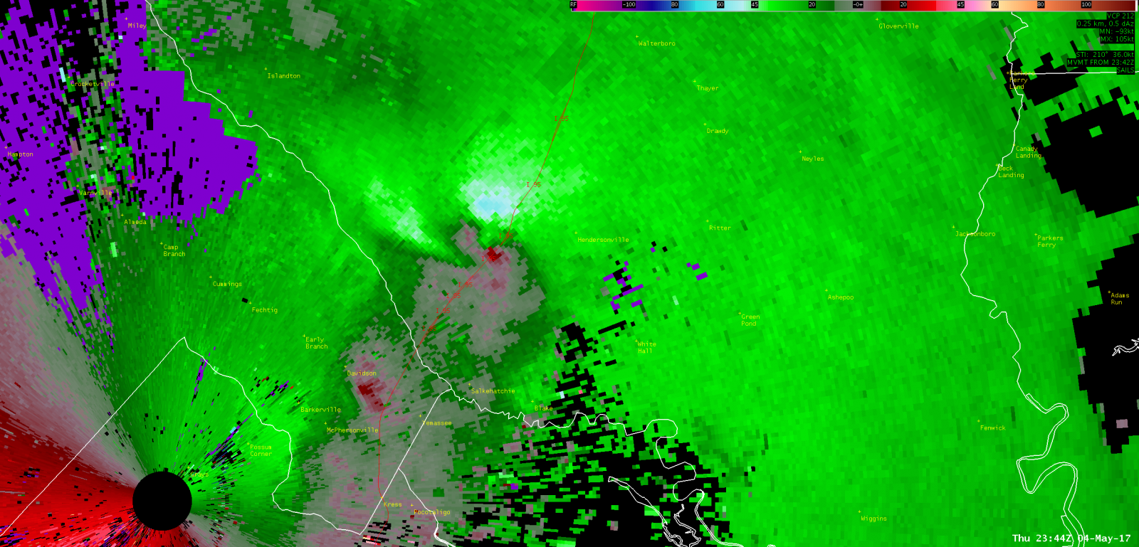
| Colleton County, SC (near Hendersonville) | ||
|
KCLX Base (0.5 Degree) Reflectivity (May 4, 2017 - 744 PM EDT) |
KCLX Base (0.5 Degree) Storm-relative Velocity (May 4, 2017 - 744 PM EDT) |
|
|
|
|
|
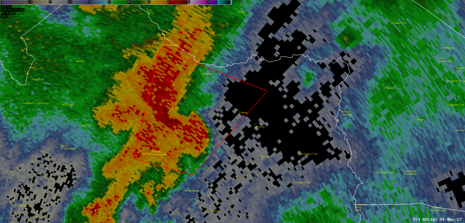
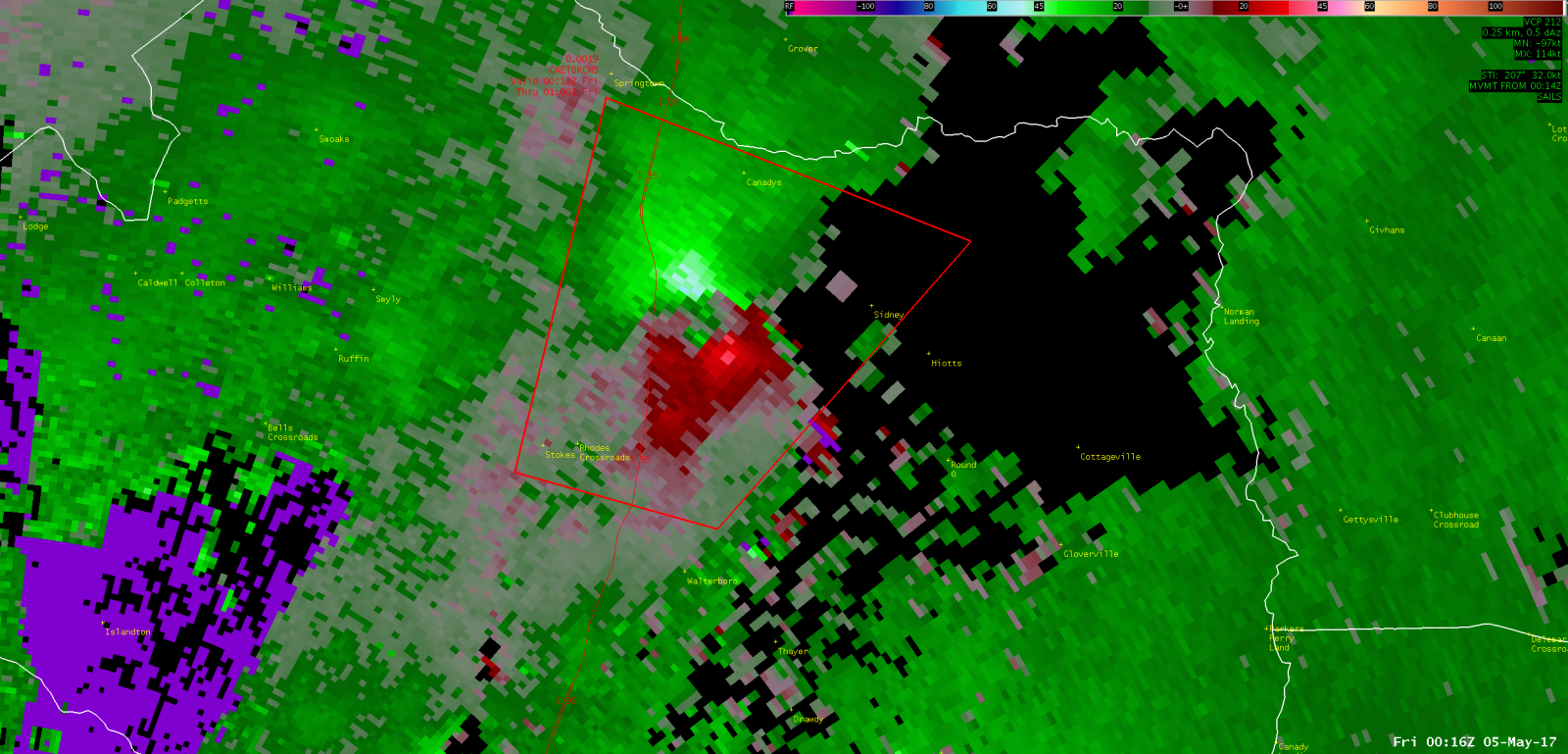
| Colleton County, SC (near Walterboro) | ||
|
KCLX Base (0.5 Degree) Reflectivity (May 4, 2017 - 816 PM EDT) |
KCLX Base (0.5 Degree) Storm-relative Velocity (May 4, 2017 - 816 PM EDT) |
|
|
|
|
|
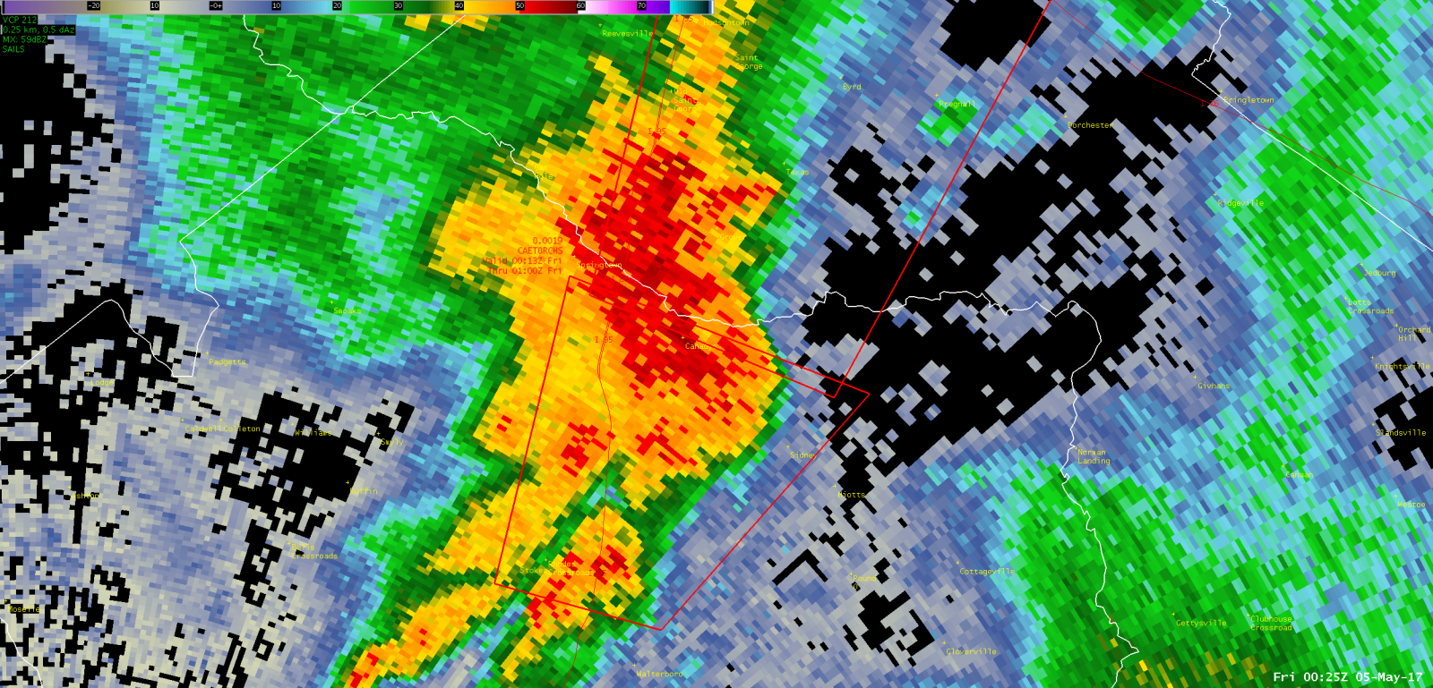
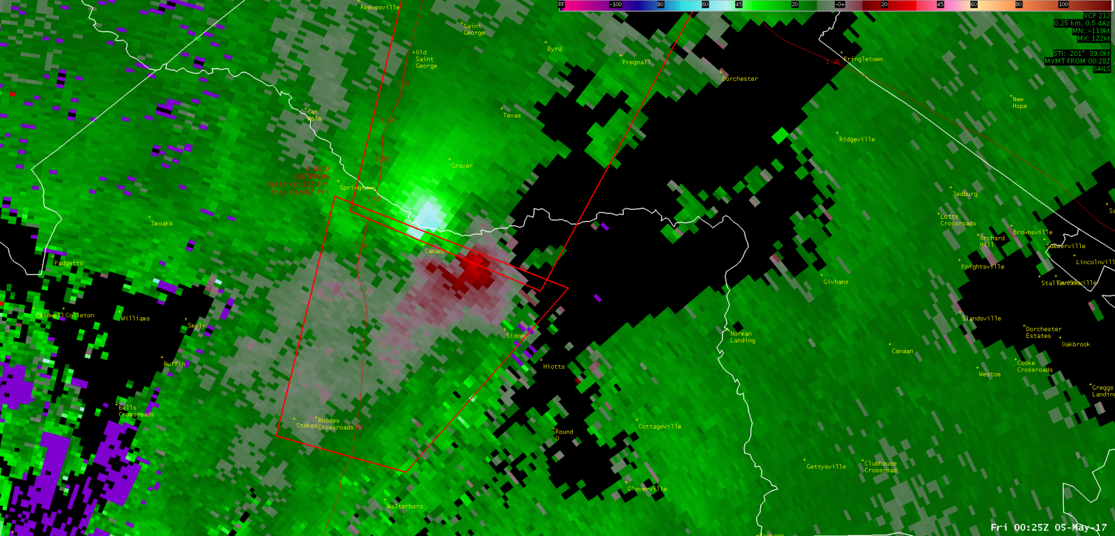
| Colleton/Dorchester Counties, SC (near Canadys) | ||
|
KCLX Base (0.5 Degree) Reflectivity (May 4, 2017 - 825 PM EDT) |
KCLX Base (0.5 Degree) Storm-relative Velocity (May 4, 2017 - 825 PM EDT) |
|
|
|
|
|
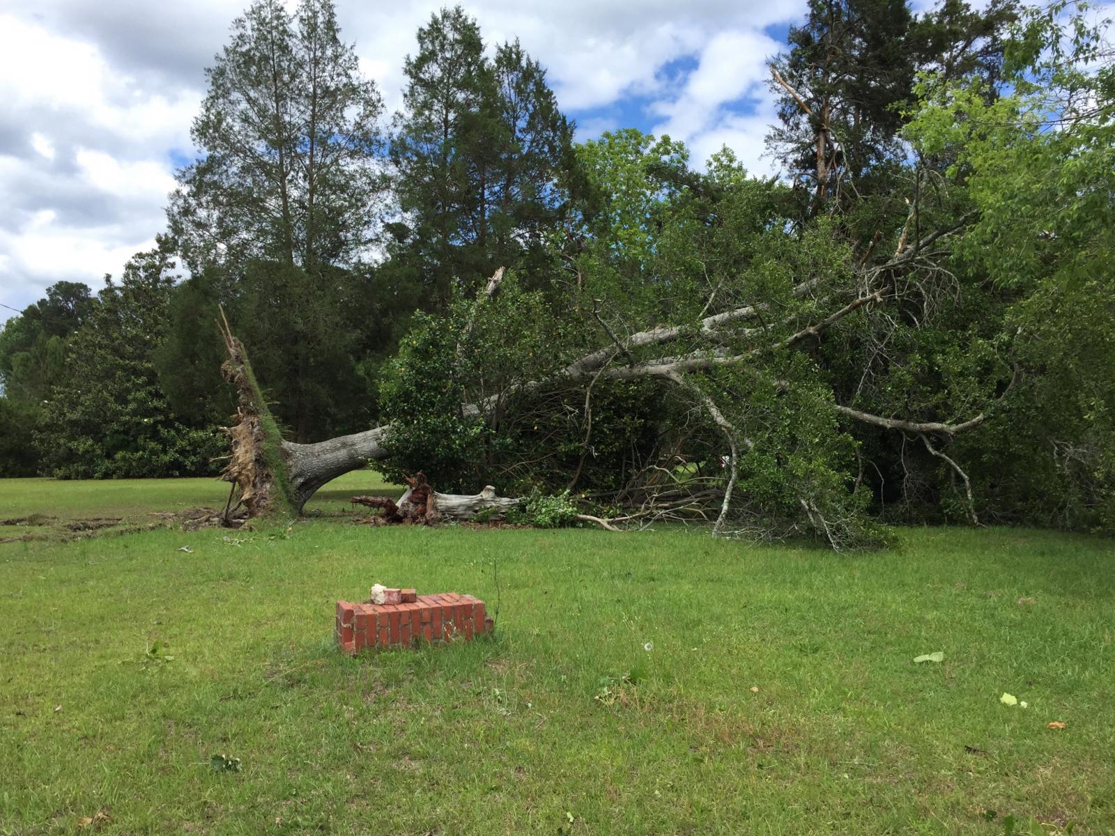
Images courtesy of NWS Charleston, SC; click to enlarge
| Chatham County, GA (Garden City) | ||||
 |
 |
 |
||
| Colleton/Dorchester Counties, SC | ||||
 |
 |
 |
||
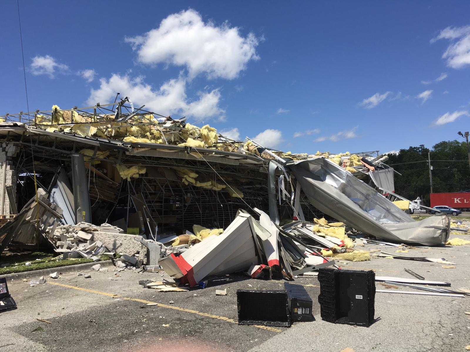
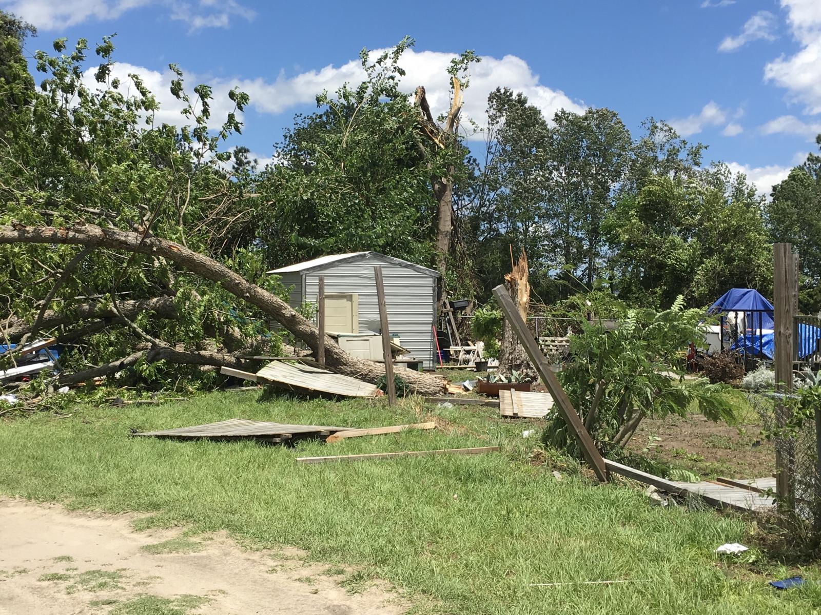
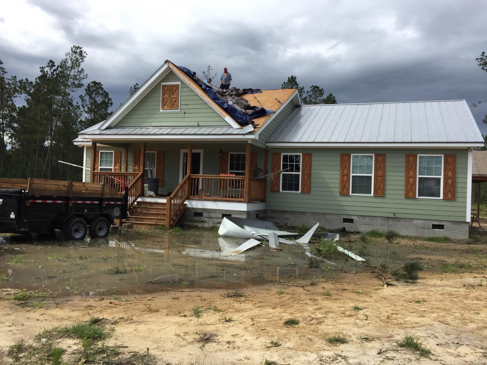
Public Information Statement
National Weather Service Charleston SC
518 PM EDT Mon May 8 2017

...MULTIPLE TORNADOES CONFIRMED ON 05/04/17...

...TORNADO CONFIRMED NEAR HENDERSONVILLE IN COLLETON COUNTY SOUTH
CAROLINA...

Location...Hendersonville in Colleton County South Carolina
Date...May 4 2017
Estimated Time...745 PM EDT
Maximum EF-Scale Rating...EF1
Estimated Maximum Wind Speed...110 mph
Maximum Path Width...440 yards
Path Length...12.56 miles
Beginning Lat/Lon...32.7933 N / 80.7796 W
Ending lat/Lon...32.9558 N / 80.6811 W
* Fatalities...0
* Injuries...0

* The information in this statement is preliminary and subject to
change pending final review of the event(s) and publication in
NWS Storm Data.

...Summary...
The National Weather Service in Charleston SC has confirmed a
tornado near Hendersonville in Colleton County South Carolina on
May 4, 2017.

The tornado initially touched down approximately 1/2 mile southwest
of the Hendersonville Rest Area off Interstate 95, with a north/northeast
intermittent path of approximately 5.5 miles. Along the path, the
tornado crossed State Road S-15-28, snapping several trees. The
tornado then continued north-northeast where it caused damage to a
house and barn just north of Black Creek Road. Several snapped
and uprooted trees along with a few downed power poles also occurred
at this location. The tornado then continued north-northeast crossing
Magellan Road, where approximately 100 trees were snapped. The tornado
then continued north-northeast where it produced tree and home
damage along Cane Branch Road. At this point, the tornado path
became continuous from the damage along Cane Branch Road until the
tornado dissipated along the I-95.

Damage to a house on Cane Branch Road included a 6500 pound boat and
trailer being displaced about 30 yards from their original position, a
golf cart being lifted up and moved about 20 yards, two large
branches being driven through the side of the house, several windows
being broken out, and significant damage to metal roofing material.
In addition, the house was shifted a bit on its foundation. Numerous
trees were snapped near the property of this home. The tornado then
continued north-northeast toward Sniders Highway (Route 63), where
it produced minor roof and siding damage to a mobile home, tossed a
trampoline into a tree line about 20 feet off the ground, snapped a
few trees and severely damaged/turned an old barn on its side. The
tornado then crossed Highway 63, snapping 2 power poles and causing
minor roof and siding damage to a 2 story house. The tornado
continued north crossing Donald Court Point, where a mobile home was
seen leaning on cinder blocks along with skirting destroyed. Two
adjacent mobile homes also received minor skirt damage. The tornado
then continued north, gaining strength and width while approaching
Walterboro, South Carolina.

The maximum tornado strength (EF1) and width (1/4 mile) was surveyed
about 1/4 mile west of a large shopping complex along Highway 64,
where approximately 1000 trees were either snapped, uprooted and/or
severely damaged. The tornado then continued on a north/northeast
track damaging dozens of trees while crossing Mount Carmel Road,
before lifting approximately 2 miles north of exit 57 on Interstate
95 off of Windmere Lane where damage to trees, power lines and a
large billboard occurred.

This information can also be found on our website at
weather.gov/chs.

For reference: the Enhanced Fujita Scale classifies tornadoes
into the following categories:

EF0...Wind speeds 65 to 85 mph
EF1...Wind speeds 86 to 110 mph
EF2...Wind speeds 111 to 135 mph
EF3...Wind speeds 136 to 165 mph
EF4...Wind speeds 166 to 200 mph
EF5...Wind speeds greater than 200 mph

&&

...TORNADO CONFIRMED NEAR WALTERBORO IN COLLETON COUNTY SOUTH
CAROLINA...

Location...Walterboro in Colleton County South Carolina
Date...May 4 2017
Estimated Time...816 PM EDT
Maximum EF-Scale Rating...EF1
Estimated Maximum Wind Speed...100 mph
Maximum Path Width...125 yards.
Path Length...6.02 miles.
Beginning Lat/Lon...32.9880 N / 80.6490 W
Ending Lat/Lon...33.0571 N / 80.5859 W
* Fatalities...0
* Injuries...0

* The information in this statement is preliminary and subject to
change pending final review of the event(s) and publication in
NWS Storm Data.

...Summary...
The National Weather Service in Charleston SC has confirmed a
tornado near Walterboro in Colleton County South Carolina on
May 4, 2017.

The tornado touched town just west of McLeod Road, damaging the
roofing and siding of a home on McLeod Road. The tornado then
traveled north-northeast producing intermittent damage along the
path. The tornado produced extensive tree damage along Allen Creek
just to the west of Route 15 where approximately 100 trees were
snapped off, uprooted, or severely damaged. The tornado produced
fence damage along Route 15 just north of Allen Creek and thereafter
produced intermittent tree damaging along the path. The tornado
crossed a corn field about 2 miles east of Canadys where a
convergent wind pattern was clearly evident. The tornado snapped off,
uprooted or damaged numerous trees in this area before dissipating
just south of the Edisto River.

This information can also be found on our website at
weather.gov/chs.

For reference: the Enhanced Fujita Scale classifies tornadoes
into the following categories:

EF0...Wind speeds 65 to 85 mph
EF1...Wind speeds 86 to 110 mph
EF2...Wind speeds 111 to 135 mph
EF3...Wind speeds 136 to 165 mph
EF4...Wind speeds 166 to 200 mph
EF5...Wind speeds greater than 200 mph

&&

...TORNADO CONFIRMED NEAR CANADYS IN COLLETON AND DORCHESTER
COUNTY SOUTH CAROLINA...

Location...Canadys in Colleton and Dorchester County South Carolina
Date...May 4 2017
Estimated Time...825 PM EDT
Maximum EF-Scale Rating...EF1
Estimated Maximum Wind Speed...100 mph
Maximum Path Width...150 yards
Path Length...2.02 miles
Beginning Lat/Lon...33.0530 N / 80.5850 W
Ending Lat/Lon...33.0817 N / 80.5807
* Fatalities...0
* Injuries...0

* The information in this statement is preliminary and subject to
change pending final review of the event(s) and publication in
NWS Storm Data.

...Summary...
The National Weather Service in Charleston SC has confirmed a
tornado near Canadys in Colleton and Dorchester Counties South
Carolina on May 4, 2017.

The tornado developed just southeast of the second tornado likely
as the second tornado was dissipating and then traveled north-
northeast across the Edisto River and into Dorchester County. This
tornado snapped off, uprooted and damaged trees about 2 miles east
of Canadys. The damage from this tornado was clearly separate and
about 1000 feet east of the second tornado as it approached the
Edisto River. The tornado then dissipated along Utsey Hill Road.

This information can also be found on our website at
weather.gov/chs.

For reference: the Enhanced Fujita Scale classifies tornadoes
into the following categories:

EF0...Wind speeds 65 to 85 mph
EF1...Wind speeds 86 to 110 mph
EF2...Wind speeds 111 to 135 mph
EF3...Wind speeds 136 to 165 mph
EF4...Wind speeds 166 to 200 mph
EF5...Wind speeds greater than 200 mph

$$

Public Information Statement
National Weather Service Charleston SC
943 PM EDT Sat May 6 2017

...HIGH END EF1 TORNADO CONFIRMED NEAR GARDEN CITY IN CHATHAM
COUNTY GEORGIA...

Location...Garden City in Chatham County Georgia
Date...May 4 2017
Estimated Time...550 pm
Maximum EF-Scale Rating...EF1 Estimated
Maximum Wind Speed...110 MPH
Maximum Path Width...120 yards
Path Length...2.86 miles
Beginning Lat/Lon...32.0805 N / 81.1480 W
Ending lat/Lon...32.1178 N / 81.1292 W
* Fatalities...0
* Injuries...5

* The information in this statement is preliminary and subject to
change pending final review of the event(s) and publication in
NWS Storm Data.

...Summary...
The National Weather Service in Charleston SC has maintained the high end
EF1 rating for the tornado that struck the southern portion of Garden City,
GA in Chatham County Georgia on May 4 2017.

The tornado began near the intersection of Seaboard Coastline
Drive and Telfair Junction roads. At this location, damage was
mainly limited to some snapped trees and minor wind damage to the
bottom skirts of some mobile office trailers. The tornado
continued northward with the next damage area along Alfred Street,
just east of Market Street. At this location there were some
snapped trees and minor damage to the wall of one home, which was
partially blow down, causing the garage door to blow out. From
this point, the tornado moved northward producing sporadic, non-
continuous damage. About one third of a metal roof of an
industrial building just north of Market Street was damaged. Next
the tornado moved toward the more industrial and commercial area
just south of U.S. 80, where it did significant damage to the
Advance Auto Parts store. Three walls collapsed and the roof was
heavily damaged and shifted halfway off the remaining rear wall.
At this point, the tornado had is strongest winds, estimated to be
around 110 mph. The rating was capped at a high end EF1 due to
the lack of damage or much less significant damage to structures
immediately around the store. There were also five people injured
inside the Advance Auto Parts store, and at least 5 cars were
heavily damaged from the front wall of the store falling on them.
The tornado continued to do very sporadic and more minor damage as
it moved north of Highway 21, finally terminating at the Port of
Savannah-Garden City. At the port, it pushed over some shipping
containers and did minor damage to some container tanks in the
area. The tornado then moved into the Savannah River and
dissipated.

This information can also be found on our website at
weather.gov/chs.

For reference: the Enhanced Fujita Scale classifies tornadoes
into the following categories:

EF0...Wind speeds 65 to 85 mph
EF1...Wind speeds 86 to 110 mph
EF2...Wind speeds 111 to 135 mph
EF3...Wind speeds 136 to 165 mph
EF4...Wind speeds 166 to 200 mph
EF5...Wind speeds greater than 200 mph

$$
Acknowledgments
Upper air analyses and mesoanalyses were obtained from the NOAA/NWS Storm Prediction Center. Surface analyses were obtained from the NOAA/NWS Weather Prediction Center. Local radar graphics were created using GR2Analyst version 2.60 for Windows.


 Coastal Flood