|
There are many forecast challenges faced by meteorologists at the Charleston, SC National Weather Service Forecast Office. We are constantly trying to utilize the latest technology and scientific research to improve our forecasts and impact-based decision support services. |
Forecast Challenges: Sea Breeze | Thunderstorms | Fog | Rip Currents | Tropical Cyclones | Waterspouts
Technology: Radar | Satellites | Computer Models | Weather Balloons
Research: Local Studies/Event Reviews
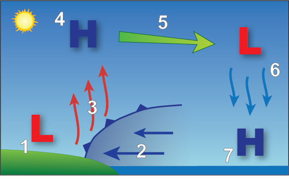
Schematic of the sea breeze circulation. #2 represents the cooler ocean air moving inland as the heated air rises over land (#1).
The sea breeze is a mesoscale phenomenon driven by the temperature (and thus pressure) differences between the land and sea. The resulting circulation can have a big impact on many aspects of the weather across southeast South Carolina (SC) and southeast Georgia (GA), including temperatures, winds, and thunderstorms, as well as rip currents. Cooler temperatures, clearing skies and breezy conditions can typically be expected after the passage of the sea breeze. The sea breeze "boundary" created by the temperature difference can help initiate the development of showers and thunderstorms as the warm, moist air is forced upward as the cooler air moves in from the sea (see second photo below). The sea breeze can also enhance rip currents due to the increase in onshore winds.
|
|
|
| Satellite imagery showing cumulus clouds along the sea breeze boundary near the coast. | Satellite imagery showing thunderstorms developing along the sea breeze boundary. |
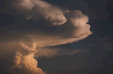
Cumulonimbus (thunderstorm) cloud.
Thunderstorms can produce a variety of hazards including damaging winds, large hail, tornadoes and deadly cloud-to-ground lightning. The NWS classifies thunderstorms as "severe" when winds of 58 miles per hour (mph) or greater and/or 1 inch diameter hail or larger are expected. Note that although thunderstorms can sometimes produce excessive lightning, this alone is not enough to trigger the NWS to issue a Severe Thunderstorm Warning. Tornado Warnings are issued by the NWS when either a reliable report of a tornado (or funnel cloud) is received or doppler radar indicates strong enough rotation capable of producing a tornado. Severe Thunderstorm and Tornado Watches are issued by the NWS Storm Prediction Center, in conjunction with the local Weather Forecast Offices, when conditions are favorable for such severe weather.
In this area, severe thunderstorms are most frequent from Spring through Fall when temperatures are normally warm and moisture is high. A local severe weather climatology can be found here. Given that thunderstorms are relatively frequent across the area and tornadoes can occur with little warning, it is important to understand how to stay safe. Predicting severe weather events as well as the process of issuing severe weather warnings is a great challenge, mainly due to the often marginal nature of severe weather in this part of the country.
Fog is essentially a cloud on the ground. It occurs when air is cooled to the dewpoint temperature, or the temperature at which air becomes satured with water vapor. When this happens, the water vapor turns into liquid water, a process known as condensation. Condensation can occur many different ways and the processes by which it occurs determines the type of fog. Click here to learn more about the different types of fog. No matter the type of fog, it can significantly hamper aviation and marine traffic.
The most common types of fog across southeast SC and southeast GA are radiation fog and sea fog. Radiation fog develops at night with sufficient low-level moisture when skies are relatively clear and winds are light. In this setup, longwave radiation can be effectively emitted from earth to space, allowing the surface to cool. Of course, the proximity to the Atlantic Ocean provides an ideal source of moisture throughout much of the year. Often times the fog is shallow and thus hard to predict.
Advection fog is another type of fog, meaning that it is caused by the advection or transport of warm, moist air over a colder surface. Sea fog is a specific type of advection fog and occurs when warm, moist air flows over relatively colder ocean waters. This typically is a cool season weather phenomena, occasionally impacting the local area from November through April. Sea fog is a concern not only to forecasters, but also to mariners, motorists and others who are along and near the coast. Once sea fog forms it becomes a dangerous hazard to navigation as visibility is severely reduced. Sometimes radiation fog that forms over land will move over harbors, inlets, the intra-coastal and nearby Atlantic waters due to light offshore winds. While this is not pure sea fog, it can also be a concern for mariners.
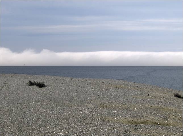
Sea fog off the coast.
Depending upon how cool the ocean temperatures get during the late autumn, winter and early spring, on average there are about 10-20 days each year where sea fog develops across the local area. Visibility in the fog can be reduced to 1/2 nautical mile (nm) or less.
Although it is not uncommon for sea fog to develop in an unstable environment, its formation is much more likely in a stable air mass. Thus, there would usually need to be a temperature inversion over the ocean to prevent vertical mixing. The inversion traps moisture and prevents it from evaporating into the air from the ocean. Generally the lower the inversion is in relation to the ocean's surface, the more favorable the conditions are for sea fog formation.
Another factor is the amount of saturation of the air, with relative humidity as close to 100% as possible favoring its formation. However, if other factors are present, then even relative humidity values as low as around 85 to 90% are sufficent. Also, the air temperature over the ocean should be similar or a little warmer than the water temperatures. More importantly we look for the dew point of the air that is similar or higher than the water temperature.
Finally, the winds and their fetch over the water are considered. While sea fog is not uncommon at speeds such as 20 mph, it is more likely during lighter winds at speeds of less than 10 or 15 mph. And winds that are blowing over the ocean with a longer fetch will also aid in its formation. So for the local area we look for winds that blow from an onshore direction, which results in a more favorable fetch. And many times if the wind is onshore and sea fog forms, then the fog can also move over land, the intra-coastal waterway and various harbors and inlets. Thus, the fog is not only a hazard to mariners, but also to those on land as well.
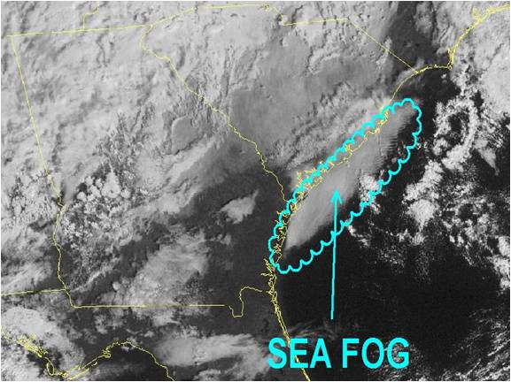
Visibile satellite image showing sea fog along the South Carolina and Georgia coasts.
NWS Charleston, SC will issue a Dense Fog Advisory via the Marine Weather Message when visibility of 1/2 nautical mile (nm) or less is expected. However, given that there are so few observations/reports of visibility over the marine area, forecasters have the option of issuing a Dense Fog Advisory even when visibilities are near 3/4-1 nm. When visibilities are reduced to 1/2 nm or less the Port of Charleston and the Port of Savannah will be closed to navigation.
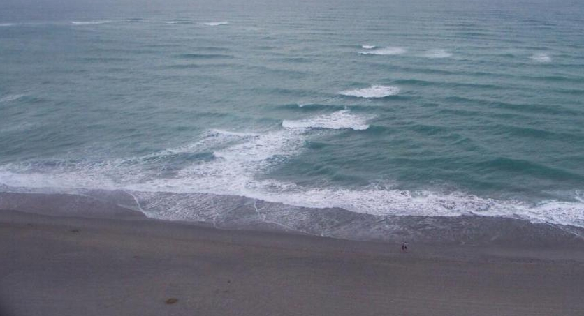
Rip current extending away from the beach.
Many people are familiar with beach hazards such as lightning, jellyfish, stingrays or even the rare occurrence of a shark. But, there is another hazard that can be just as dangerous, and causes an estimated one hundred deaths a year. This is more than floods, tornadoes, lightning and hurricanes, and is far more common than a shark attack. The hazard we are referring to are rip currents. Rip currents are only dangerous if you don't know what they are, or if you are not a good swimmer as they can carry you a few hundred feet offshore in less than a minute.
Rip currents are powerful channels of water flowing quickly away from shore. They typically extend from the shoreline, through the surf zone, and past the line of breaking waves. Rip currents can occur at any beach with breaking waves, including the Great Lakes.
How Do Rip Currents Form?
Incoming waves break on the sand bars before they break in the channel area. These breaking waves cause an increase in water level over the sand bars relative to the channel level. This increase in water level is known as a set-up. As a result of the higher water level over the sand bars, a pressure gradient is created. This pressure gradient drives incoming feeder currents and waves. As these waves approach the shoreline, they usually break at an angle, generating a long shore current. This current flows parallel to or along the beach, sometimes converging with other currents, until there is too much of a water buildup. This buildup of water needs to find a way to go back seaward, and typically occurs through a break in the sandbar, where water is channelized into a narrow current known as a rip current. Other times rip currents can result from a wave's natural variability or when a current traveling along the shoreline encounters a structure such as a pier, a groin (rock pile) or jetty and is forced offshore.
Where Do Rip Currents Form?
Rip currents usually form at low spots or breaks in sandbars, and also near structures such as groins, jetties and piers. Rip currents can be very narrow or hundreds of yards wide. The seaward pull of rip currents can vary: sometimes the rip current ends just beyond the line of breaking waves, but sometimes rip currents continue to push hundreds of yards offshore. Recent research even indicates that in a few cases the rip current can come back into the surf zone from offshore.
When Do Rip Currents Form?
While rip currents can be found on surf beaches every day, if there are certain wave, tide, and beach profile conditions, the amount and intensity of rip currents can quickly increase. Research has shown that there is an increased risk of rip currents when the following factors occur:
In general, rip currents are most likely to be dangerous during high surf conditions as the wave height and wave period increase, as more wave energy impacts the surf.
How You Can Identify Rip Currents
Rip currents can sometimes be identified if you like for some of these familiar signs:
How You Can Avoid Rip Currents
How to Survive and Escape Rip Currents
Misconceptions
Many people believe that rip currents will pull you under water. This is not true! Rip currents will pull you away from shore, but not pull you under water. Drownings occur when people pulled offshore are unable to keep themselves afloat and swim back to shore. This may be due to any combination of fear, panic, exhaustion, or lack of swimming skills. Remember, the rip current will eventually dissipate, even if this is far from shore, so there is no use fighting against the current. Let it carry you out until its seaward flow stops, or attempt to swim sideways and out of the current. Think of the rip current like you are on a treadmill that cannot be turned off. You need to get off the treadmill, or in this case out of the rip current, to no longer fight the effects of the opposing force.
In some regions rip currents are referred to by other, incorrect terms such as rip tides and undertow. These terms may confuse people and negatively impact public education efforts.
Characteristics
Types
Local Rip Current Program
NWS Charleston issues a beach/surf zone forecast daily (spring through fall) that includes a rip current risk. You can also obtain the rip current risk by visiting our marine/rip current webpage, by calling our forecast line at 1-843-744-0303 or by listening to NOAA Weather Radio All Hazards.
Rip Current Links
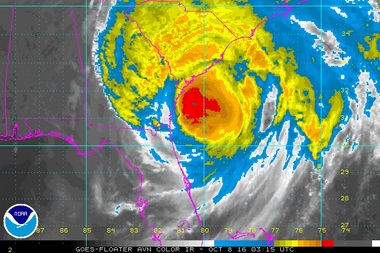
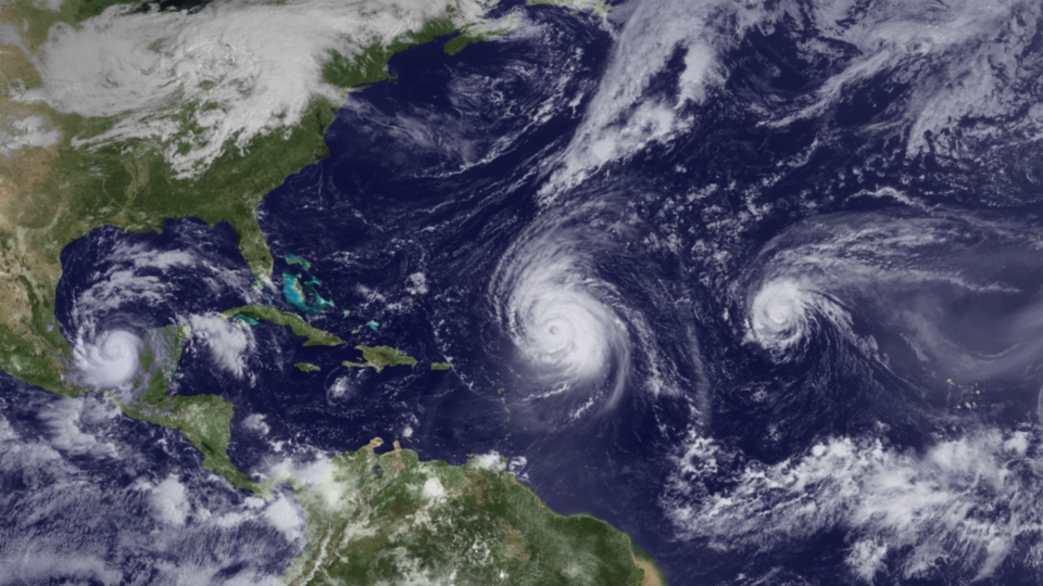
GOES Infrared satellite image of Hurricane Matthew (2016) off the Southeast U.S. coast.
Tropical cyclones (including hurricanes and tropical storms) are warm-core low pressure systems that pose a significant threat to the entire Southeast U.S. coast, mainly from late summer through early Fall. They have the potential to bring strong winds, significant storm surge, heavy rainfall and tornadoes. Forecasting such storms is handled by the National Hurricane Center in Miami, FL, but coordination with local Weather Forecast Offices occurs if a storm threatens the U.S. mainland.
Improved observations, especially from reconnaissance aircraft and satellites, has led to better track forecasts but intensity forecasts still remain quite problematic. This is due to the lack of highly detailed observations in and around tropical cyclones and thus our limited understanding of the dynamics (e.g., eyewall replacement cycles) associated with such systems.
Click here for more information on forecasting models used by the National Hurricane Center. You can also check out a climatology of tropical cyclones for southeast South Carolina and southeast Georgia on our tropical weather webpage.
A waterspout is defined as a rapidly rotating column of air extending from the base of moderate or towering cumulus clouds to the surface of the water. Only rarely does the visible funnel extend from the cloud base to the sea surface. However, you can assume if the funnel extends at least halfway between the cloud base and the surface of the water, that there is an invisible funnel extending all the way down.
Waterspouts will form in areas of low-level convergence where swirls of colliding air becomes vertically extended and intensified by rapidly growing clouds. Waterspouts will climb skyward from the waters surface to the cloud base. This is different for tornadoes, which develop from a “meso-cyclone,” or a large rotating thunderstorm, with roots in the middle levels of the atmosphere that grow downward to the surface.
Climatology and Statistics
Differences Between Tornadic and Non-Tornadic Waterspouts
Life Cycle
The waterspout life cycle is characterized by the following 5 stages:
Forecasting
Mature waterspouts contain wind speeds in excess of 35 knots and as such, it has been the custom in the NWS to issue a Special Marine Warning in order to warn mariners of the potentially hazardous winds. If our forecast confidence is high we will attempt to give more advance notice of waterspouts that may occur in products such as the Area Forecast Discussion and the Marine Weather Statement.
Factors
Weak vertical shear in the lower levels of the atmosphere, with an average wind speed less than 10 knots from the surface through approximately 25,000 feet.
Convective instability in the lowest 10,000 feet of the atmosphere.
Abundant low level moisture with dry air above.
Updrafts of weak to moderate strength.
An approaching weak boundary such as the sea breeze front to provide a lifting mechanism.
Lines of cumulus clouds, especially if they are intersecting. Cloud lines are extremely important in that very few waterspouts will occur in isolated cumulus clouds. Individual shower outflows or downdrafts in the cloud line act to concentrate the weak spin in the air. Then an updraft in an adjacent part of the cloud line further produces weak spin, forming the spiraling flow and the waterspout itself.
Temperature gradients, such as those that occur in cool air outflow boundaries.
Most occur in developing cumulus (cumulus mediocris) or towering cumulus clouds (cumulus congestus), but usually not cumulonimbus clouds. The maximum cloud tops are about 25,000 feet, but usually more likely between 10,000 and 15,000 feet.
Warm sea surface temperatures. The minimum temperature that is necessary is usually around 78 degrees Fahrenheit. Of the documented waterspout events in the local waters over 80% occurred with the sea surface temperature of 80-85 degrees Fahrenheit.
Surface winds mainly 10 knots or less, although waterspouts can still occur with winds as high as 15 knots.
Continuity from previous days.
Safety
Your best course of action if you sight a waterspout is to determine the direction it is moving, then move in a direction away from the waterspout. If a waterspout does not appear to be moving, then it may be approaching your position. Again, move in a direction away from that movement. Proceed with caution and make sure all are wearing their life jacket. If possible get to a safe harbor. When in a safe location, contact the National Weather Service with your report including its location, direction, and speed if known.
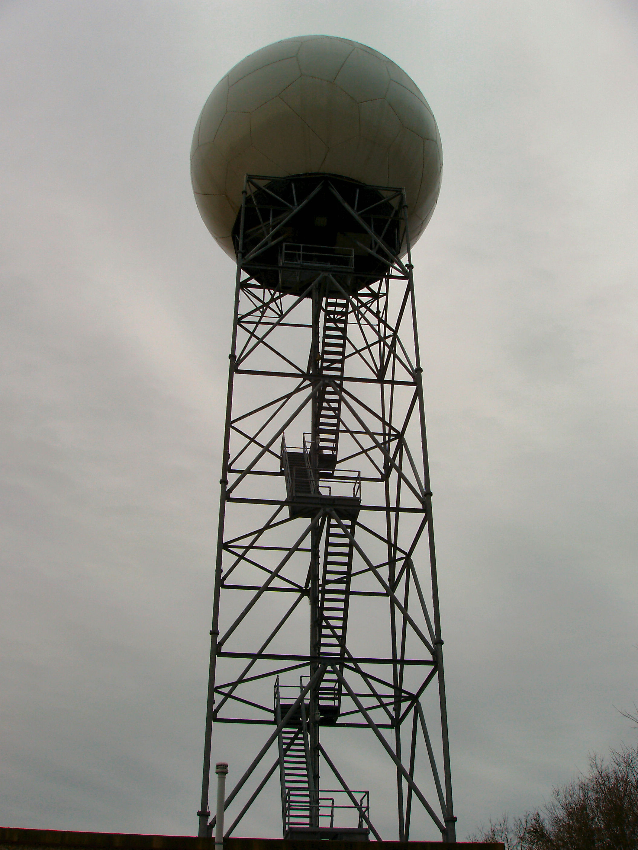
The KCLX WSR-88D transmits energy at 750,000 watts. This power enables a beam of energy generated by the radar to travel long distances, and detect many kinds of weather phenomena. It also allows energy to continue past an initial shower or thunderstorm near the radar, thus seeing additional storms farther away. Many other radar systems do not have this kind of power, nor can they look at more than one "slice" of the atmosphere. During severe weather, the KCLX radar can interrogate 14 different elevations every 4.5-5 minutes, generating a radar image of each elevation, or one new radar image about every 20 seconds.
The WSR-88D obtains weather information (precipitation and wind) based upon returned energy generated and received at the Radar Data Acquisition (RDA) unit. The radar emits a burst of energy from a 28 foot diameter antenna/dish inside the radome. If the energy strikes an object (e.g., rain drop, snow, hail, bug, bird, dust, etc), the radar beam is scattered in all directions. A small fraction of that scattered energy is directed back toward the radar. Computers at the radar facility analyze the strength of this returned pulse and the time it took to travel to the object and back. The radar's computers also measure the phase shift/change of the reflected pulse of energy which is converted to velocity units of the object, either toward or away from the radar. Information on the movement of objects either toward or away from the radar can be used to estimate the speed of the wind. This ability to "see" the wind is what enables the NWS to detect the formation of tornadoes and thus allows Tornado Warnings to be issued with more advanced notice.
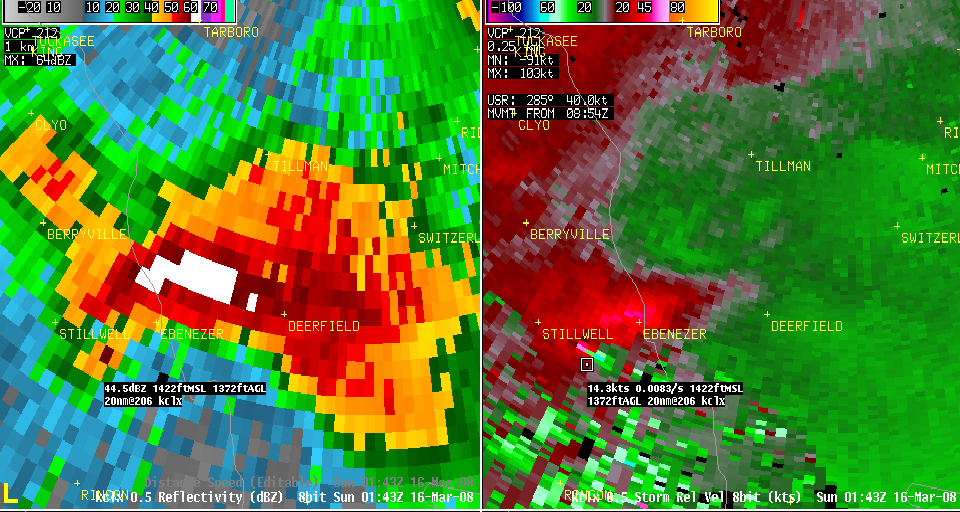
KCLX WSR-88D doppler radar reflectivity (left) and storm-relative velocity (right) imagery of the Effingham County, GA EF-2 tornadoes on March 15, 2008.
In addition to basic reflectivity products which most people are familiar with from television and the internet, other products constantly disseminated include radar precipitation estimates in the form of hourly and storm total products. These rainfall estimates are the impetus for issuing Flood/Flash Flood Warnings.
In 2012 the radar was upgraded with dual polarization technology that collects data on the horizontal and vertical properties of precipitation targets (e.g., rain, snow, hail) and non-weather targets (e.g., insect, ground clutter). The new data and products will assist our forecasters in all types of weather interrogation, especially with heavy rainfall and frozen precipitation such as snow and sleet.
Satellites are used heavily by meteorologists, especially over the ocean where surface observations are sparce. Thus, they are very important in observing and predicting tropical cyclones. There are generally 2 types of satellites: geostationary and polar-orbiting. Geostationary satellites (see above) remain at a fixed location above the Earth while polar-orbiting satellites constantly rotate around the Earth as it spins on its axis. The advantage of geostationary satellites is that they provide coverage over the same area all the time, despite being farther away. Polar-orbiting satellites are closer to the Earth but are always changing their positions. For more information on the satellites we use, click here.
NWS meteorologists use their knowledge of how the atmosphere works along with their experience to forecast what the weather will be an hour from now all the way through the next 7 days. As you go farther out in time, however, computer models are more heavily relied upon. These models incorporate vast amounts of data, including surface observations (land and sea), upper-air observations, and remote sensing (e.g., satellite and radar) observations to determine the current state of the atmosphere. This is very important since reliably predicting the future state of the atmosphere depends on what is happening now.
Some models are "global" which means they use observations from around the world to predict the state of the atmosphere over the entire Earth and are typically best resolving large-scale weather systems due to their larger coverage area and spatial resolution. Other models are more "regional" or "local" and these use data from the "global" models as inputs but are designed to focus more on resolving smaller-scale features such as squall lines or even individual thunderstorms.
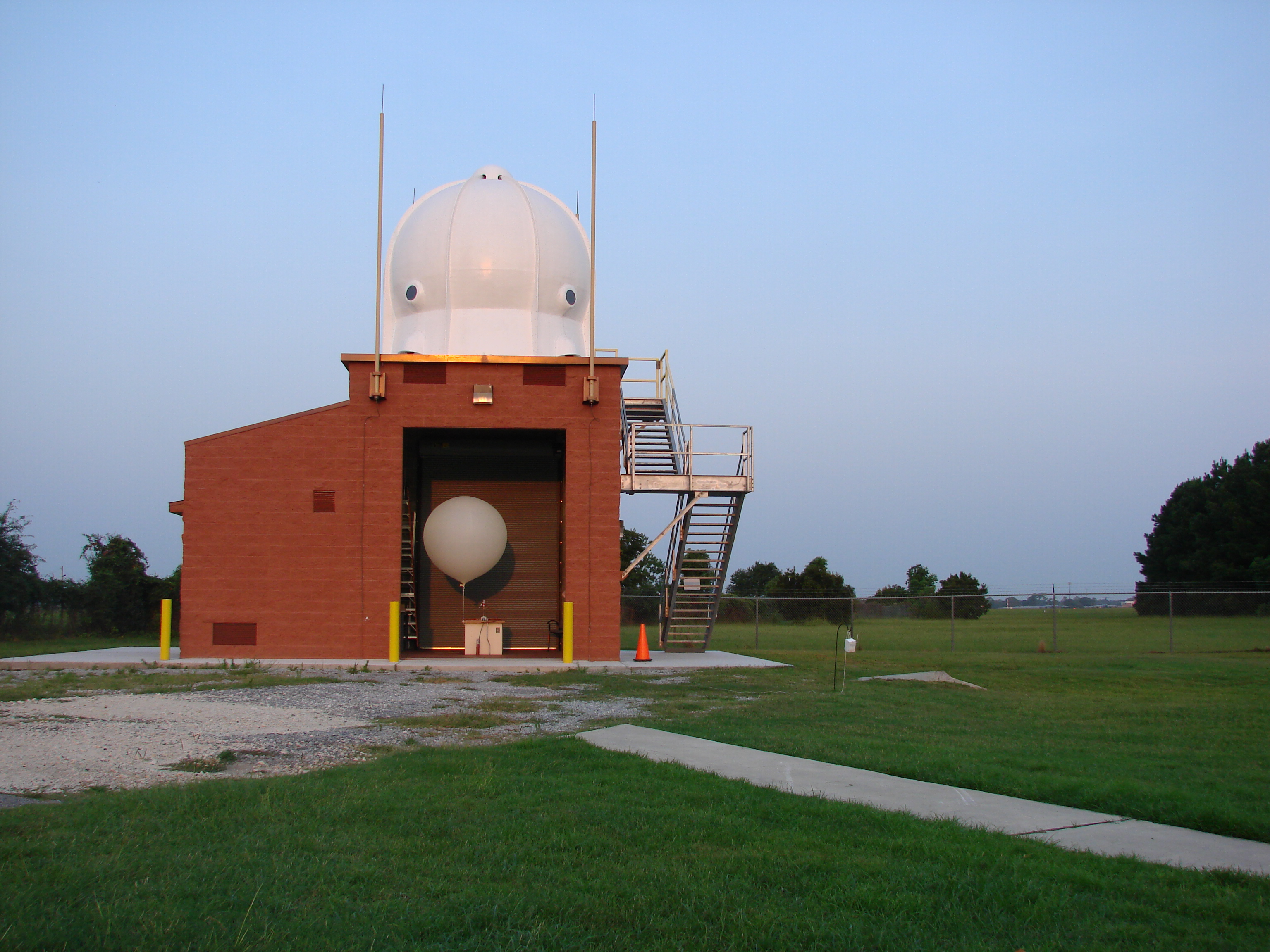
Many NWS weather forecast offices release weather balloons two times per day (or more during severe weather) to take observations of the upper atmosphere, including temperature, humidity, pressure and winds. These observations are used to initialize the weather computer models. For more information on weather balloons, visit our Upper Air web page.


 Coastal Flood