|
Welcome to the new NWS Duluth Marine Page. Any questions or comments can be sent to nws.duluth@noaa.gov.
|
| Duluth | Marquette | |||
 |
 |
|||
| Reflectivity | Reflectivity | |||
Nearshore Forecast
211
FZUS53 KDLH 031600
NSHDLH
Nearshore Marine Forecast
National Weather Service Duluth MN
1100 AM CDT Mon Aug 3 2026
For waters within five nautical miles of shore on Lake Superior.
Waves are the significant wave height - the average of the highest
1/3 of the wave spectrum. Occasional wave height is the average of
the highest 1/10 of the wave spectrum.
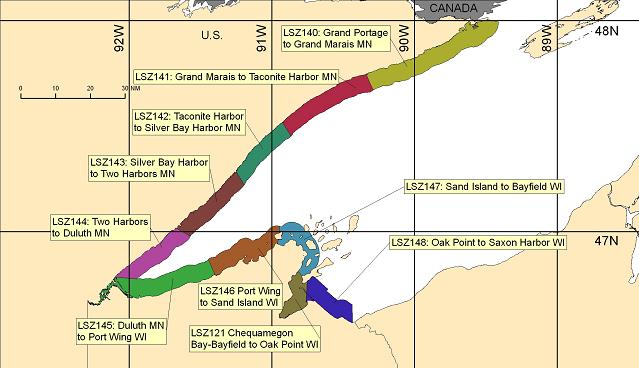
LSZ140-032200-
Grand Portage to Grand Marais MN-
1100 AM CDT Mon Aug 3 2026
...SMALL CRAFT ADVISORY IN EFFECT FROM LATE TONIGHT THROUGH
TUESDAY MORNING...
.REST OF TODAY...Southeast wind 5 to 10 knots. Mostly sunny.
Waves 1 foot or less.
.TONIGHT...East wind 5 to 10 knots becoming southwest 15 to
20 knots with gusts to around 30 knots after midnight. Rain
showers likely after midnight. Waves 1 to 2 feet building to 2 to
4 feet after midnight.
.TUESDAY...West wind 15 to 20 knots. Gusts up to 25 knots
decreasing to 20 knots late in the morning, then increasing to
25 knots in the afternoon. Slight chance of rain showers in the
morning. Waves 2 to 4 feet. A small craft advisory may be needed.
.TUESDAY NIGHT...West wind 10 to 15 knots. Gusts up to 25 knots
early in the evening. Partly cloudy. Waves 2 to 4 feet subsiding
to 1 to 3 feet in the late evening and overnight. A small craft
advisory may be needed.
$$
LSZ141-032200-
Grand Marais to Taconite Harbor MN-
1100 AM CDT Mon Aug 3 2026
.REST OF TODAY...East wind 5 knots. Partly sunny. Waves 1 foot or
less.
.TONIGHT...Northeast wind 5 knots becoming east after midnight,
then becoming southwest 10 to 15 knots with gusts to around
20 knots early in the morning. Rain showers likely and slight
chance of thunderstorms after midnight. Waves 1 to 2 feet.
.TUESDAY...West wind 10 to 15 knots with gusts to around
20 knots. Chance of rain showers and slight chance of
thunderstorms in the morning. Waves 1 to 2 feet.
.TUESDAY NIGHT...West wind 5 to 10 knots. Gusts up to 20 knots
early in the evening. Partly cloudy. Waves 1 to 2 feet.
$$
LSZ142-032200-
Taconite Harbor to Silver Bay Harbor MN-
1100 AM CDT Mon Aug 3 2026
.REST OF TODAY...Variable winds 10 knots or less becoming east
5 knots in the afternoon. Partly sunny. Waves 1 foot or less.
.TONIGHT...Northeast wind 5 knots becoming southeast with gusts
to around 20 knots after midnight, then becoming southwest with
gusts to around 20 knots early in the morning. Rain showers
likely and slight chance of thunderstorms after midnight. Waves
1 foot or less.
.TUESDAY...West wind 5 to 10 knots with gusts to around 20 knots.
Chance of rain showers and slight chance of thunderstorms in the
morning. Waves 1 to 2 feet.
.TUESDAY NIGHT...West wind 5 knots. Partly cloudy. Waves 1 foot
or less.
$$
LSZ143-032200-
Silver Bay Harbor to Two Harbors MN-
1100 AM CDT Mon Aug 3 2026
.REST OF TODAY...East wind 5 knots. Partly sunny. Waves 1 foot or
less.
.TONIGHT...Northeast wind 5 to 10 knots becoming south 10 to
15 knots with gusts to around 25 knots after midnight, then
becoming southwest with gusts to around 25 knots early in the
morning. Rain showers likely and slight chance of thunderstorms
after midnight. Waves 1 to 2 feet.
.TUESDAY...West wind 5 to 10 knots. Gusts up to 20 knots late in
the afternoon. Chance of rain showers and slight chance of
thunderstorms in the morning. Waves 1 to 2 feet.
.TUESDAY NIGHT...West wind 5 knots. Partly cloudy. Waves 1 foot
or less.
$$
LSZ144-032200-
Two Harbors to Duluth MN-
1100 AM CDT Mon Aug 3 2026
...SMALL CRAFT ADVISORY IN EFFECT FROM 10 PM CDT THIS EVENING
THROUGH TUESDAY MORNING...
.REST OF TODAY...East wind 5 to 10 knots. Partly sunny. Waves
1 foot or less.
.TONIGHT...East wind 5 to 10 knots becoming southeast 10 to
15 knots with gusts to around 20 knots late in the evening, then
becoming south 15 to 20 knots with gusts to around 25 knots after
midnight becoming west with gusts to around 25 knots early in the
morning. Showers likely and slight chance of thunderstorms after
midnight. Waves 1 to 2 feet.
.TUESDAY...West wind 10 to 15 knots. Gusts up to 20 knots early
in the morning then 20 knots early in the afternoon. Chance of
rain showers and slight chance of thunderstorms in the morning.
Waves 1 to 2 feet.
.TUESDAY NIGHT...West wind 5 to 10 knots. Mostly clear. Waves
1 foot or less.
$$
LSZ145-032200-
Duluth MN to Port Wing WI-
1100 AM CDT Mon Aug 3 2026
...SMALL CRAFT ADVISORY IN EFFECT FROM 10 PM CDT THIS EVENING
THROUGH TUESDAY MORNING...
.REST OF TODAY...Northeast wind 5 to 10 knots. Mostly sunny.
Waves 1 foot or less.
.TONIGHT...Southeast wind 5 to 10 knots becoming south 15 to
20 knots with gusts to around 25 knots in the late evening and
early morning, then becoming southwest with gusts to around
25 knots early in the morning. Showers likely and slight chance
of thunderstorms after midnight. Waves 1 to 2 feet.
.TUESDAY...West wind 10 to 15 knots with gusts to around 20 knots
easing to 5 to 10 knots with gusts to around 20 knots in the
afternoon. Chance of showers and slight chance of thunderstorms
in the morning. Waves 1 to 2 feet.
.TUESDAY NIGHT...West wind 5 to 10 knots. Mostly clear. Waves
1 foot or less.
$$
LSZ146-032200-
Port Wing to Sand Island WI-
1100 AM CDT Mon Aug 3 2026
...SMALL CRAFT ADVISORY IN EFFECT FROM 10 PM CDT THIS EVENING
THROUGH TUESDAY MORNING...
.REST OF TODAY...Northeast wind 5 knots. Mostly sunny. Waves
1 foot or less.
.TONIGHT...Southeast wind 5 knots becoming south 10 to 15 knots
with gusts to around 25 knots in the late evening and early
morning, then becoming southwest with gusts to around 25 knots
early in the morning. Chance of showers and slight chance of
thunderstorms after midnight. Waves 1 to 2 feet.
.TUESDAY...West wind 5 to 10 knots with gusts to around 20 knots.
Chance of showers and slight chance of thunderstorms in the
morning. Waves 1 to 2 feet.
.TUESDAY NIGHT...West wind 5 to 10 knots. Mostly clear. Waves
1 foot or less.
$$
LSZ147-032200-
Sand Island to Bayfield WI-
1100 AM CDT Mon Aug 3 2026
...SMALL CRAFT ADVISORY IN EFFECT FROM 10 PM CDT THIS EVENING
THROUGH TUESDAY MORNING...
.REST OF TODAY...East wind 5 knots. Mostly sunny. Waves 1 foot or
less.
.TONIGHT...Southeast wind 5 to 10 knots becoming southwest 10 to
15 knots with gusts to around 25 knots in the late evening and
overnight. Chance of showers and slight chance of thunderstorms
after midnight. Waves 1 foot or less.
.TUESDAY...West wind 5 to 10 knots with gusts to around 20 knots.
Chance of showers in the morning. Waves 1 foot or less.
.TUESDAY NIGHT...West wind 5 to 10 knots. Mostly clear. Waves
1 foot or less.
$$
LSZ150-032200-
Outer Apostle Islands Beyond 5 NM from Mainland-
1100 AM CDT Mon Aug 3 2026
...SMALL CRAFT ADVISORY IN EFFECT FROM 10 PM CDT THIS EVENING
THROUGH TUESDAY MORNING...
.REST OF TODAY...South wind 5 knots becoming east in the
afternoon. Mostly sunny. Waves 1 foot or less.
.TONIGHT...Southeast wind 5 to 10 knots becoming south 10 to
15 knots with gusts to around 25 knots in the late evening and
overnight. Chance of showers after midnight. Waves 1 to 2 feet.
.TUESDAY...West wind 10 to 15 knots with gusts to around
20 knots. Chance of rain showers in the morning. Waves 1 to
2 feet.
.TUESDAY NIGHT...West wind 5 to 10 knots. Partly cloudy. Waves
1 foot or less.
$$
LSZ121-032200-
Chequamegon Bay-Bayfield to Oak Point WI-
1100 AM CDT Mon Aug 3 2026
...SMALL CRAFT ADVISORY IN EFFECT FROM 10 PM CDT THIS EVENING
THROUGH TUESDAY MORNING...
.REST OF TODAY...South wind 5 to 10 knots. Mostly sunny. Waves
1 foot or less.
.TONIGHT...South wind 10 to 15 knots. Gusts up to 25 knots.
Chance of showers after midnight. Waves 1 foot or less.
.TUESDAY...West wind 10 to 15 knots. Gusts up to 20 knots early
in the morning. Chance of showers in the morning. Waves 1 foot or
less.
.TUESDAY NIGHT...West wind 5 to 10 knots becoming southwest early
in the morning. Partly cloudy. Waves 1 foot or less.
$$
LSZ148-032200-
Oak Point to Saxon Harbor WI-
1100 AM CDT Mon Aug 3 2026
...SMALL CRAFT ADVISORY IN EFFECT FROM 10 PM CDT THIS EVENING
THROUGH TUESDAY MORNING...
.REST OF TODAY...Southeast wind 5 to 10 knots. Mostly sunny.
Waves 1 foot or less.
.TONIGHT...South wind 10 to 15 knots with gusts to around
20 knots becoming southwest with gusts to around 25 knots after
midnight. Chance of showers after midnight. Waves 1 to 2 feet.
.TUESDAY...West wind 10 to 15 knots. Gusts up to 20 knots early
in the morning. Chance of showers in the morning. Waves 1 foot or
less.
.TUESDAY NIGHT...West wind 5 to 10 knots becoming southwest early
in the morning. Partly cloudy. Waves 1 foot or less.
$$
Graphical marine forecasts are available online at:
weather.gov/greatlakes
WFO DLH
Open Waters Forecast
593
FZUS63 KMQT 031401
GLFLS
Open Lake Forecast for Lake Superior
National Weather Service Marquette MI
1001 AM EDT Mon Aug 3 2026
For waters beyond 5 nautical miles of shore on Lake Superior.
Waves are the significant wave height - the average of the
highest 1/3 of the wave spectrum. Occasional wave height is the
average of the highest 1/10 of the wave spectrum.
.SYNOPSIS...
Ridging of 29.9 inches over Lake Superior this morning continues to
shift southeast today as 29.7 inch troughing approaches from the
west. The trough moves over the lake at 29.8 inches tonight into
Tuesday as a 29.4 inch low tracks over Hudson Bay. 30.0 inch ridging
returns on Wednesday as high pressure builds into the Great Lakes
from the northern Plains. For the late week and into the weekend,
Lake Superior will be between a 30.3 inch Bermuda High and a 29.6
inch low pressure around western Hudson Bay.
LSZ162-032000-
Lake Superior west of a line from Saxon Harbor WI to Grand
Portage MN beyond 5NM-
1001 AM EDT Mon Aug 3 2026 /901 AM CDT Mon Aug 3 2026/
.REST OF TODAY...South winds 5 to 15 knots backing east in the
afternoon. Waves calm to 2 feet.
.TONIGHT...East winds 5 to 15 knots becoming south 15 to 25 knots
after midnight, then veering southwest late. A chance of showers
and a slight chance of thunderstorms after midnight. Waves
building to 2 to 4 feet.
.TUESDAY...West winds 15 to 25 knots diminishing to 10 to
20 knots in the afternoon, then increasing to 15 to 25 knots
late. A slight chance of showers through early afternoon. Waves
subsiding to 1 to 3 feet, then building to 2 to 4 feet.
.TUESDAY NIGHT...West winds 10 to 20 knots diminishing to 5 to
15 knots after midnight. Waves subsiding to calm to 2 feet.
.WEDNESDAY...Southwest winds 5 to 15 knots becoming south 10 to
20 knots by mid afternoon. Waves calm to 2 feet.
.WEDNESDAY NIGHT...South winds 5 to 15 knots veering southwest
after midnight. Waves calm to 2 feet.
.THURSDAY...Southwest winds 10 to 20 knots diminishing to 5 to
15 knots. Waves calm to 2 feet.
.FRIDAY...Southwest winds 10 to 20 knots diminishing to 5 to
15 knots. Waves calm to 2 feet.
$$
LSZ263-032000-
Lake Superior from Saxon Harbor WI to Upper Entrance to Portage
Canal MI 5NM off shore to the US/Canadian border including Isle
Royale National Park-
1001 AM EDT Mon Aug 3 2026
.REST OF TODAY...South winds 5 to 15 knots backing east late.
Waves calm to 2 feet.
.TONIGHT...Southeast winds 10 to 20 knots becoming south 15 to
25 knots after midnight, then veering southwest late. A chance of
showers after midnight. Waves building to 3 to 5 feet
occasionally to 7 feet.
.TUESDAY...West winds 15 to 25 knots backing southwest late. A
slight chance of showers through early afternoon. Waves subsiding
to 2 to 4 feet.
.TUESDAY NIGHT...West winds 10 to 20 knots diminishing to 5 to
15 knots after midnight. Waves subsiding to calm to 2 feet.
.WEDNESDAY...Southwest winds 10 to 20 knots. Waves building to
1 to 3 feet.
.WEDNESDAY NIGHT...South winds 10 to 20 knots becoming southwest
5 to 15 knots after midnight. Waves subsiding to calm to 2 feet.
.THURSDAY...Southwest winds 15 to 25 knots diminishing to 10 to
20 knots. Waves building to 1 to 3 feet, then subsiding to calm
to 2 feet.
.FRIDAY...Southwest winds 10 to 20 knots. Waves building to 1 to
3 feet, then subsiding to calm to 2 feet.
$$
LSZ264-032000-
Lake Superior from Upper Entrance to Portage Canal to Manitou
Island MI 5NM off shore to the US/Canadian Border-
1001 AM EDT Mon Aug 3 2026
.REST OF TODAY...South winds 5 to 15 knots backing southeast in
the afternoon. Waves calm to 2 feet.
.TONIGHT...Southeast winds 10 to 20 knots veering south after
midnight, then increasing to 15 to 25 knots late. Waves building
to 2 to 4 feet.
.TUESDAY...Southwest winds 15 to 25 knots. A slight chance of
showers through early afternoon. Waves 2 to 4 feet.
.TUESDAY NIGHT...West winds 10 to 20 knots diminishing to 5 to
15 knots after midnight. Waves subsiding to calm to 2 feet.
.WEDNESDAY...Southwest winds 5 to 15 knots. Waves calm to 2 feet.
.WEDNESDAY NIGHT...South winds 5 to 15 knots. Waves calm to
2 feet.
.THURSDAY...Southwest winds 10 to 20 knots diminishing to 5 to
15 knots. Waves building to 1 to 3 feet, then subsiding to calm
to 2 feet.
.FRIDAY...Southwest winds 10 to 20 knots. Waves calm to 2 feet.
$$
LSZ265-032000-
Lake Superior West of Line from Manitou Island to Marquette MI
Beyond 5NM from shore-
1001 AM EDT Mon Aug 3 2026
.REST OF TODAY...South winds 5 to 15 knots becoming southeast
10 to 20 knots in the afternoon, then increasing to 15 to
25 knots late. Waves calm to 2 feet.
.TONIGHT...Southeast winds 15 to 25 knots veering south after
midnight. Waves building to 2 to 4 feet, then subsiding to 1 to
3 feet.
.TUESDAY...South winds 15 to 25 knots veering west in the
afternoon, then diminishing to 10 to 20 knots late. A slight
chance of showers. Waves subsiding to calm to 2 feet.
.TUESDAY NIGHT...West winds 10 to 20 knots. Waves calm to 2 feet.
.WEDNESDAY...West winds 10 to 20 knots becoming south 5 to
15 knots by mid afternoon. Waves calm to 2 feet.
.WEDNESDAY NIGHT...South winds 10 to 20 knots. Waves calm to
2 feet.
.THURSDAY...South winds 10 to 20 knots veering southwest. Waves
calm to 2 feet.
.FRIDAY...Southwest winds 10 to 20 knots. Waves calm to 2 feet.
$$
LSZ266-032000-
Lake Superior East of a line from Manitou Island to Marquette MI
and West of a line from Grand Marais MI to the US/Canadian Border
Beyond 5NM from shore-
1001 AM EDT Mon Aug 3 2026
.REST OF TODAY...South winds 5 to 15 knots backing southeast in
the afternoon, then increasing to 10 to 20 knots late. Waves calm
to 2 feet.
.TONIGHT...Southeast winds 15 to 25 knots veering south after
midnight, then increasing to 20 to 30 knots late. Waves building
to 2 to 4 feet.
.TUESDAY...South winds 20 to 30 knots becoming southwest 15 to
25 knots in the afternoon, then becoming west 10 to 20 knots
late. A chance of showers. A slight chance of thunderstorms by
mid afternoon. Waves building to 3 to 5 feet occasionally to
7 feet, then subsiding to 2 to 4 feet.
.TUESDAY NIGHT...West winds 5 to 15 knots. A slight chance of
showers. Waves subsiding to calm to 2 feet.
.WEDNESDAY...West winds 5 to 15 knots backing southwest by mid
afternoon. Waves calm to 2 feet.
.WEDNESDAY NIGHT...South winds 5 to 15 knots increasing to 10 to
20 knots after midnight. Waves calm to 2 feet.
.THURSDAY...South winds 5 to 15 knots increasing to 10 to
20 knots. Waves building to 1 to 3 feet.
.FRIDAY...Southwest winds 5 to 15 knots increasing to 10 to
20 knots. Waves subsiding to calm to 2 feet.
$$
LSZ267-032000-
Lake Superior from Grand Marais MI to Whitefish Point MI 5NM off
shore to the US/Canadian border-
1001 AM EDT Mon Aug 3 2026
.REST OF TODAY...West winds less than 10 knots becoming east 5 to
15 knots late. Waves calm to 2 feet.
.TONIGHT...Southeast winds 5 to 15 knots becoming south 10 to
20 knots after midnight, then increasing to 15 to 25 knots late.
Waves building to 2 to 4 feet.
.TUESDAY...South winds 15 to 25 knots veering southwest in the
afternoon, then becoming west 5 to 15 knots late. A chance of
showers and a slight chance of thunderstorms by mid afternoon.
Waves subsiding to calm to 2 feet.
.TUESDAY NIGHT...Southwest winds 5 to 15 knots veering west after
midnight. A slight chance of showers. Waves calm to 2 feet.
.WEDNESDAY...West winds 5 to 15 knots. Waves calm to 2 feet.
.WEDNESDAY NIGHT...Southeast winds 5 to 15 knots veering south
after midnight. Waves calm to 2 feet.
.THURSDAY...South winds 5 to 15 knots increasing to 10 to
20 knots. Waves building to 1 to 3 feet.
.FRIDAY...Southwest winds 5 to 15 knots backing south. Waves
subsiding to calm to 2 feet.
$$
LSZ261-032000-
MAFOR 0315/
Superior West 11400 11200 11210 11310 11420 11430 11530 11630. A
chance of showers overnight. Waves 1 foot or less this afternoon.
Waves 1 to 3 feet tonight. Waves 2 to 4 feet Tuesday morning.
Superior North Central 13310 11320 12420 11430 11520. A chance of
showers Tuesday morning. Waves 2 feet or less this afternoon.
Waves 1 to 3 feet building to 2 to 4 feet tonight. Waves 2 to 4
feet Tuesday morning.
Superior South Central 11310 12320 11330 14430. Waves 2 feet or
less this afternoon. Waves 1 to 3 feet building to 2 to 4 feet
tonight. Waves 1 to 3 feet Tuesday morning.
Superior East 12400 11300 11310 12420 12430. Waves 1 foot or less
this afternoon. Waves 1 to 3 feet building to 2 to 4 feet
tonight. Waves 3 to 5 feet Tuesday morning.
$$
WFO MQT
Experimental modernized open lake forecast is available online at
weather.gov/mqt/glftable
Graphical marine forecasts are available online at:
weather.gov/greatlakes
Other Information
Great Lakes Water Levels and Forecasts - Provided by USACE
GLERL - NOAA Great Lakes Forecast System