Severe thunderstorms which can bring large hail, damaging winds, and isolated tornadoes will be possible over parts of the central U.S. through this weekend. Thunderstorms with heavy to excessive rainfall moving from Texas into the mid-Mississippi Valley through this weekend may produce areas of flooding. Read More >
Overview
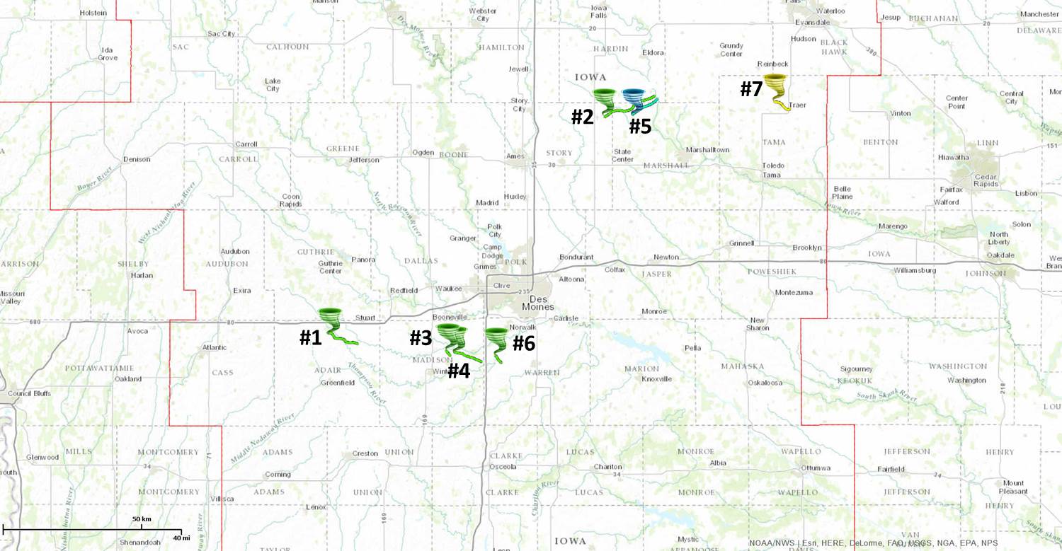
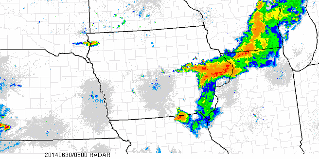
Throughout the day on June 30, 2014, a series of severe thunderstorms raked across the central corridor of Iowa, bringing a wide spectrum of high-impact severe weather on a scale not seen across the state in many years. The early phases of the event witnessed several supercell thunderstorms drop hail over four inches in diameter over parts of western Iowa. Additional storms moving in from northeast Nebraska in the late morning congealed into a damaging straight-line wind storm as they reached the Missouri River. However, multiple storms retained their supercellular characteristics along and out ahead of the squall line. These storms were responsible for seven tornadoes in Adair, Madison, Warren, Story, Marshall, Hardin, and Tama counties. By the time the storms reached east central Iowa, a well-defined bow echo had formed and accelerated eastward towards Cedar Rapids and the Quad Cities. Widespread flash flooding also took place in many areas already hit with the damaging winds and tornadoes due to a combination of training and efficient rain producing storms. Most locations under the squall line picked up a quick one to two inches of rain in under 30 minutes, which simply could not be handled by the already saturated ground. Some reporting stations recorded 4-6 inches for the calendar day.
 |
 |
| Map of all Tornado Tracks | Radar Loop of the Event from 12:00am to 9:00pm CDT June 30 |
Tornadoes:
|
|
||||||||||
|
||||||||||
|
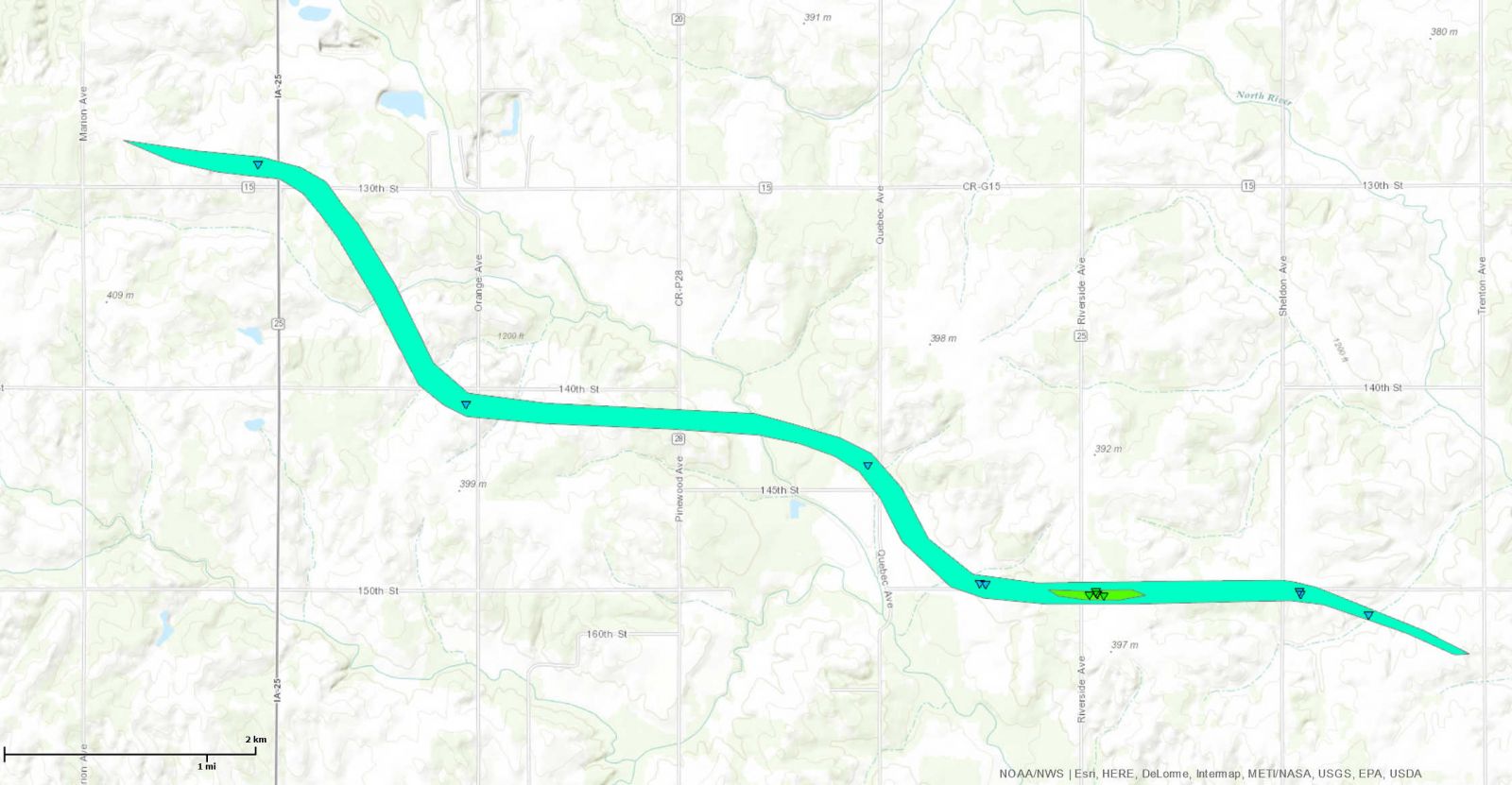
Tornado #1 - 4.0 mi SE of Casey
|
||||||||||||||||
|
||||||||||||||||
|
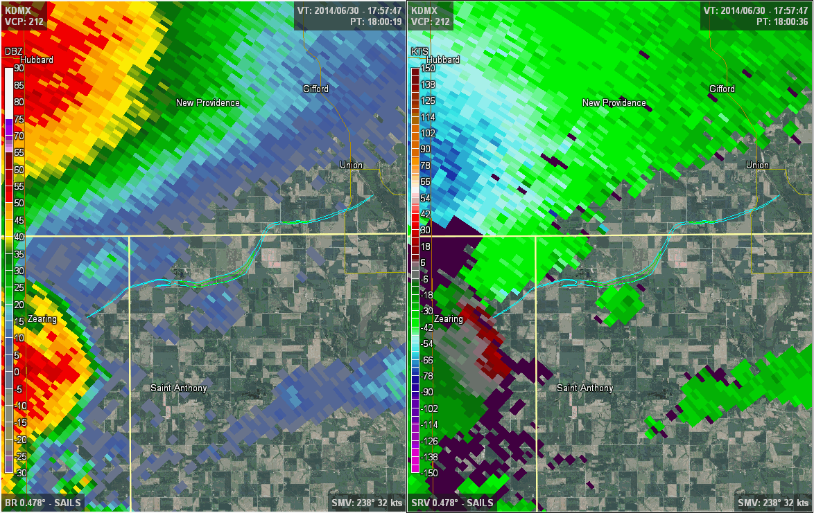
Tornado #2 - 1.7 mi E of Zearing
|
||||||||||||||||
|
||||||||||||||||
|
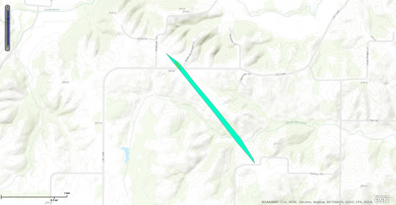
Tornado #3 - 5.7 mi NE of Winterset
|
||||||||||||||||
|
||||||||||||||||
|
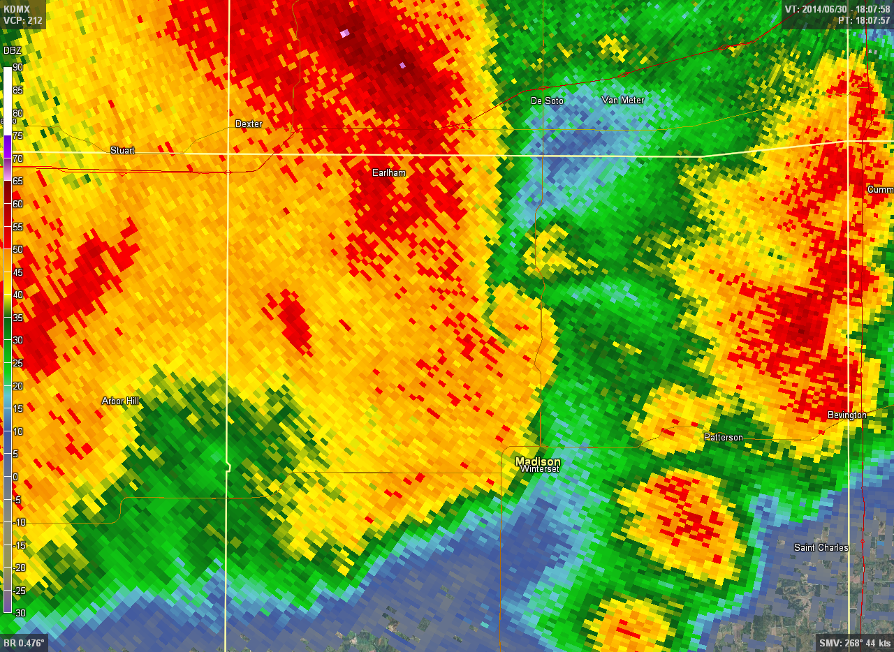
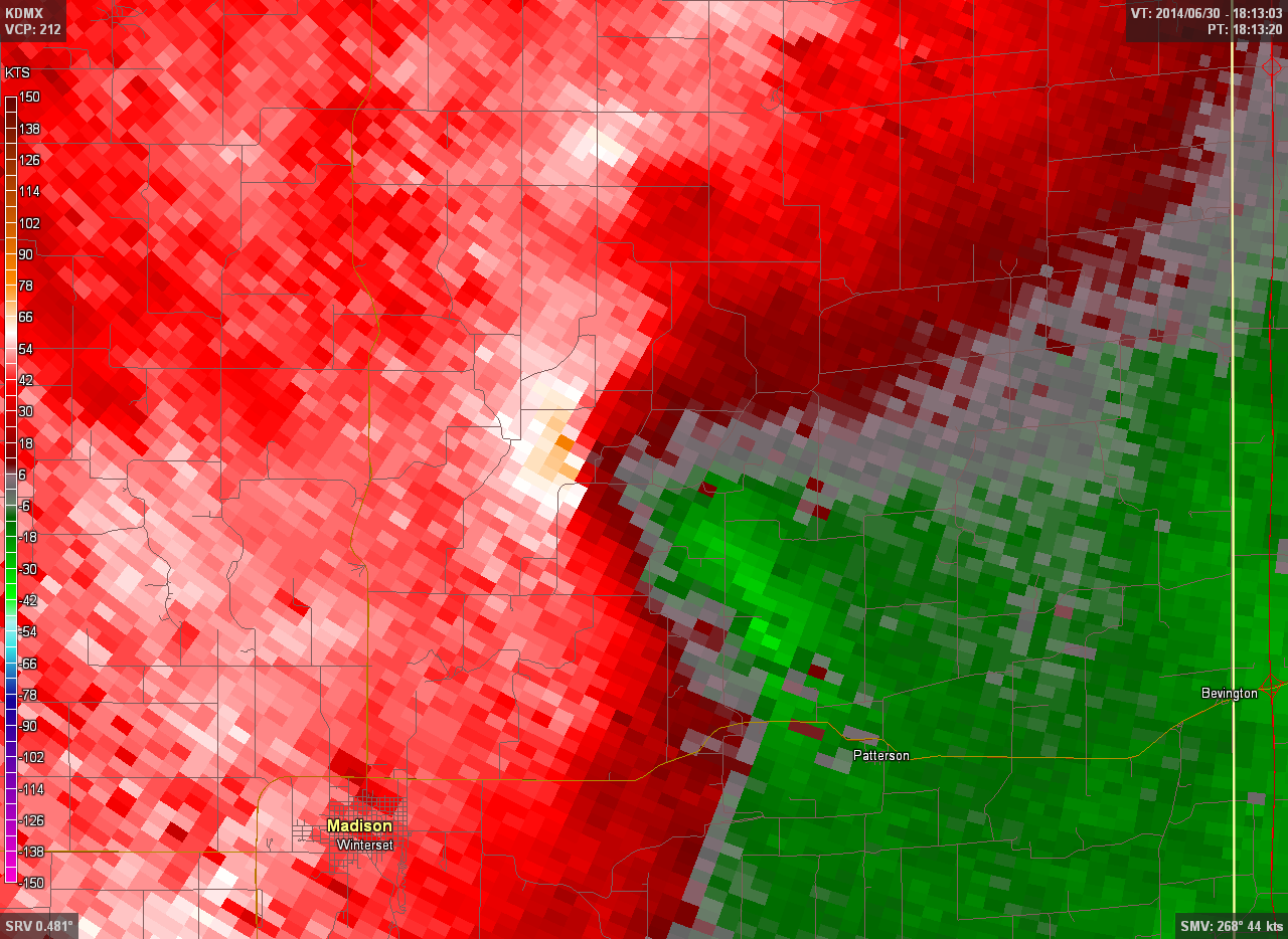
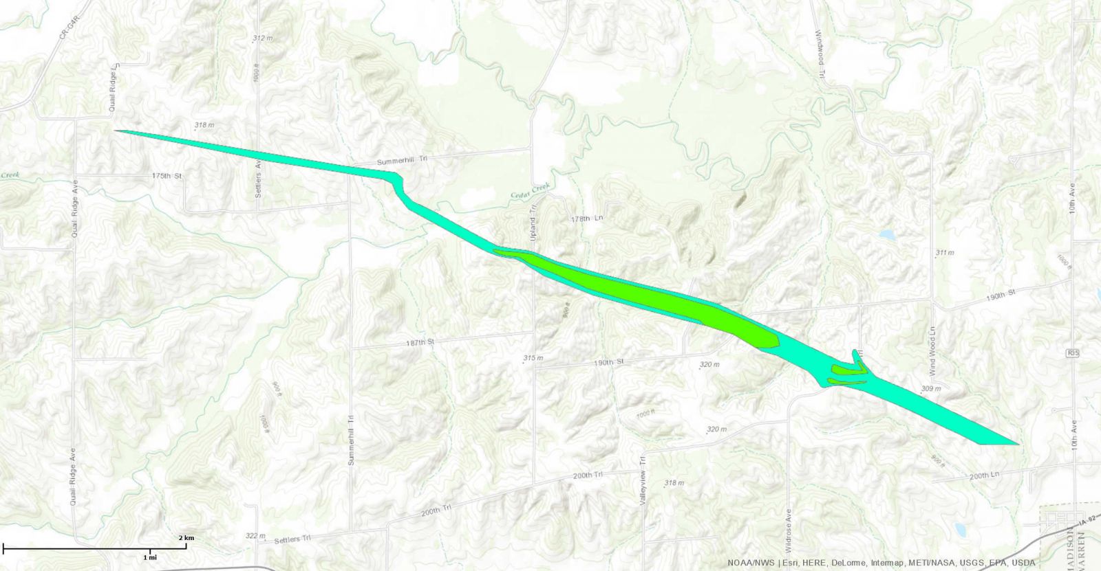
Tornado #4 - 3.9 mi NW of Patterson
|
||||||||||||||||
|
||||||||||||||||
|
Tornado #5 - 2.6 mi W of Bangor
|
||||||||||||||||
|
||||||||||||||||
|
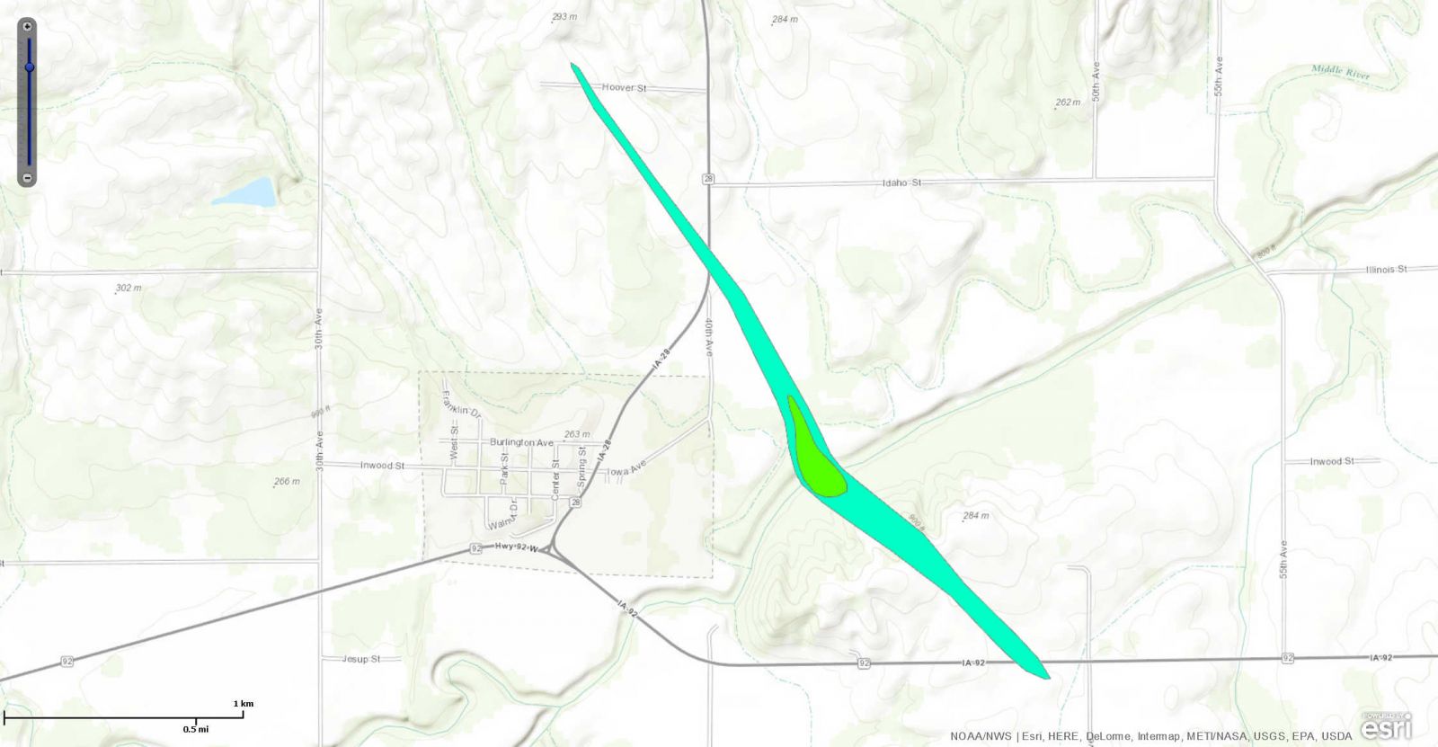
Tornado #6 - 1.0 mi N of Matensdale
|
||||||||||||||||
|
||||||||||||||||
|
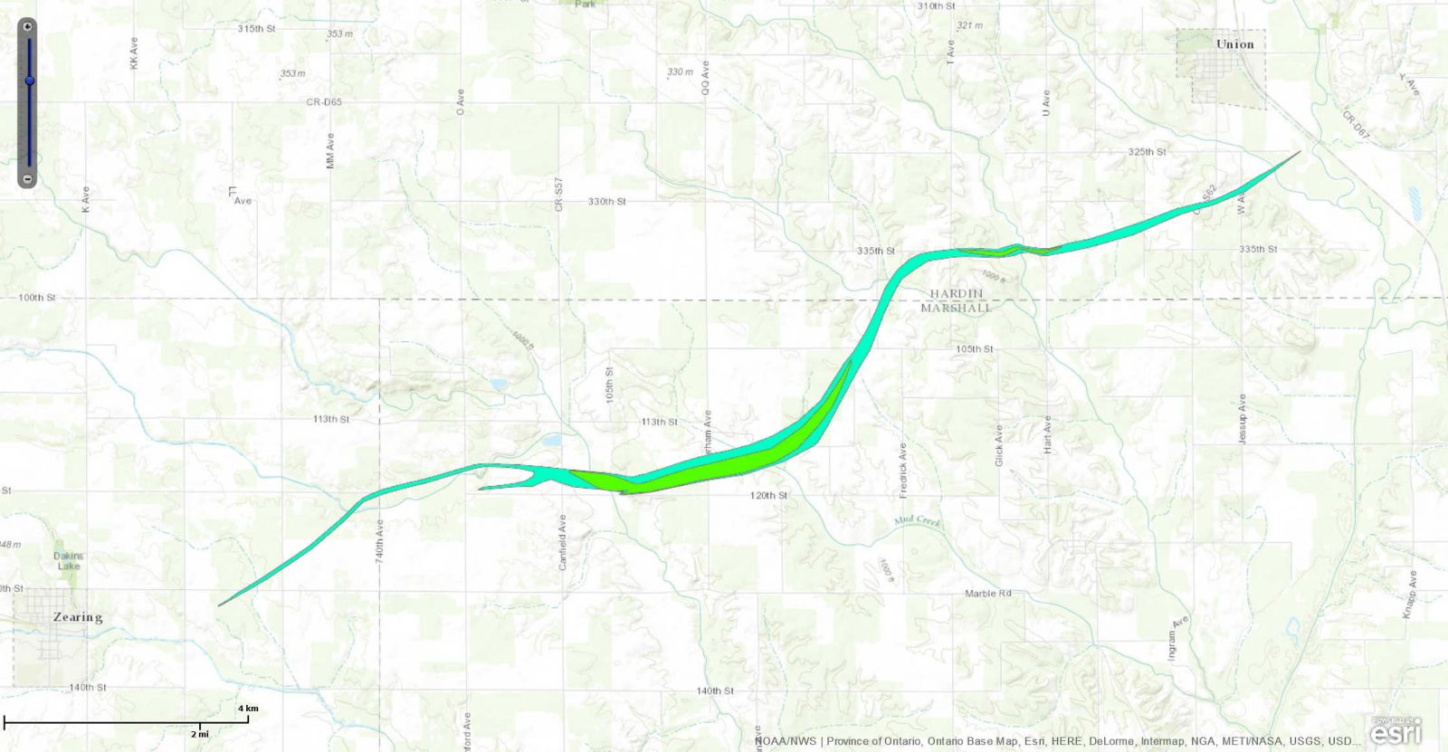
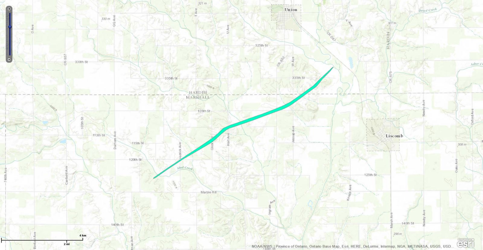
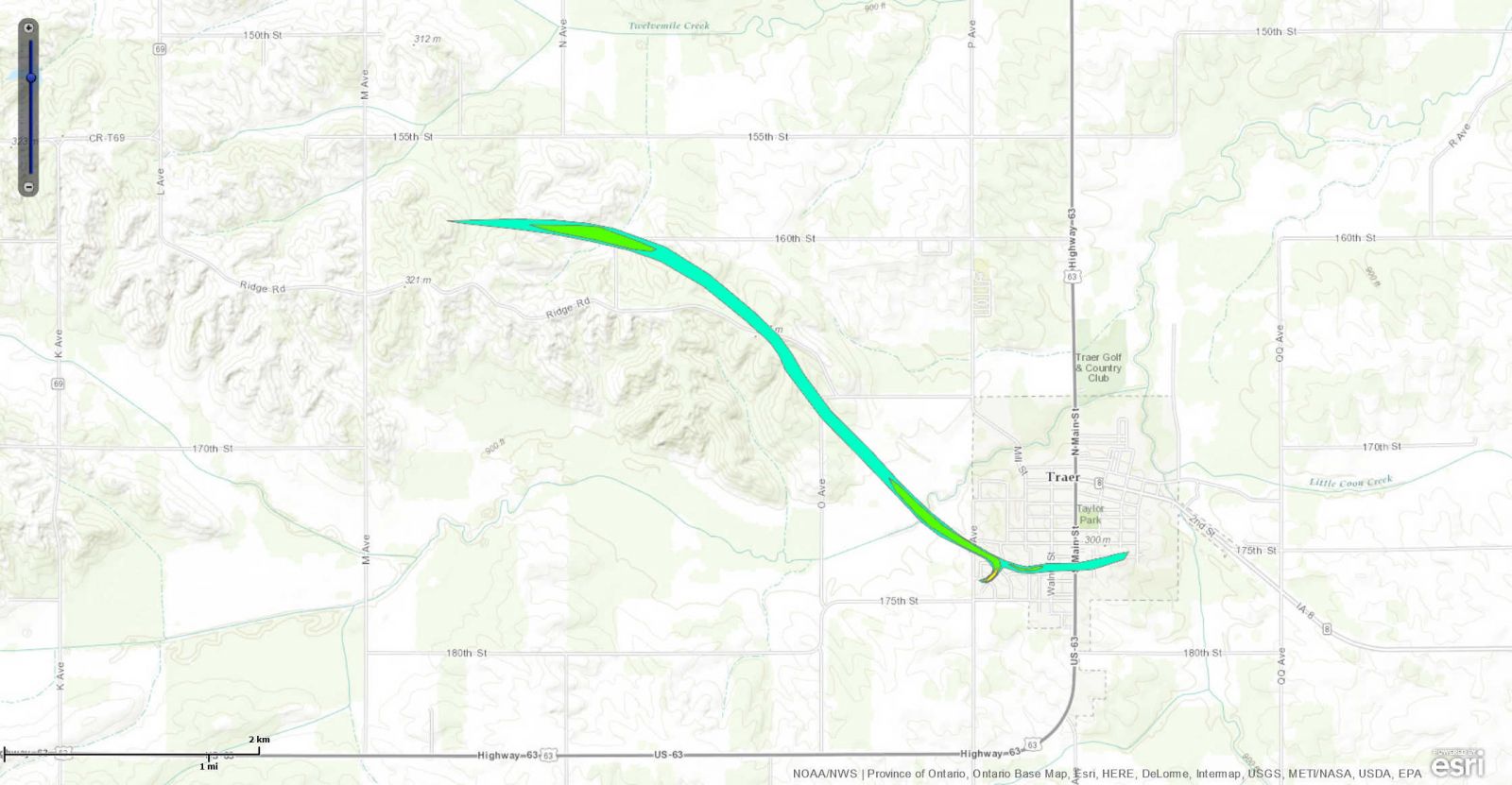
Tornado #7 - 3.3 mi W of Traer
|
||||||||||||||||
|
||||||||||||||||
The Enhanced Fujita (EF) Scale classifies tornadoes into the following categories:
| EF0 Weak 65-85 mph |
EF1 Moderate 86-110 mph |
EF2 Significant 111-135 mph |
EF3 Severe 136-165 mph |
EF4 Extreme 166-200 mph |
EF5 Catastrophic 200+ mph |
 |
|||||
Wind & Hail:
Wind
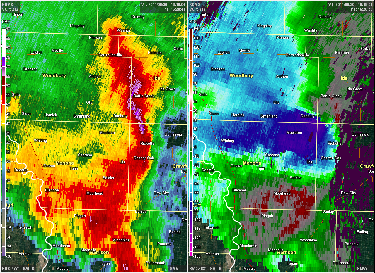
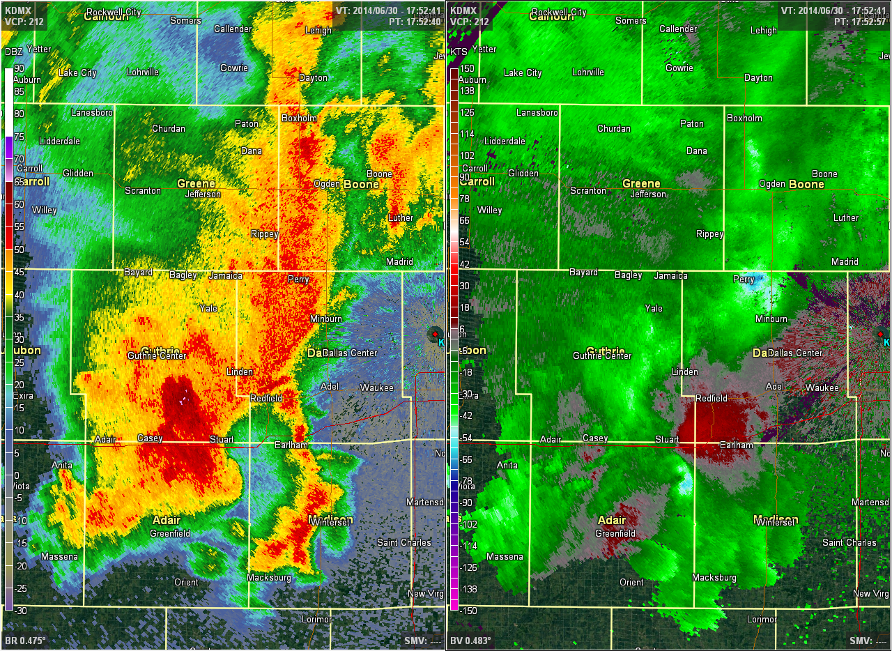
Damaging straight-line winds affected much of the southern half of Iowa at some point during the day. The first wave of damaging winds originated from a squall line tracking out of northeastern Nebraska into Woodbury and Monona counties around 10:30am. However, the strongest winds were not realized at the surface due to the storm being somewhat elevated and the bow echo weakened as it crossed Crawford County as a new complex of cells took shape to the south over Shelby and Audubon counties just before noon.
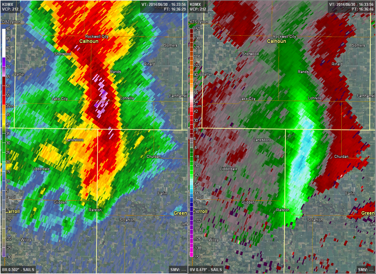
Multiple cells out ahead of this main squall line contained damaging winds. One storm in particular tracked through Ida and Sac counties fast on the heels of the 4 inch hailstorm and continued on a due east course to Tama County before being absorbed by the main squall line. WSR-88D velocity data indicated winds of 55 to 60 kts with the line as it pushed towards I-35. The aforementioned second, southern supercell merged with this line in northern Boone County, and this merger generated a small but intense region of damaging winds from NE Boone County eastward to Tama County.
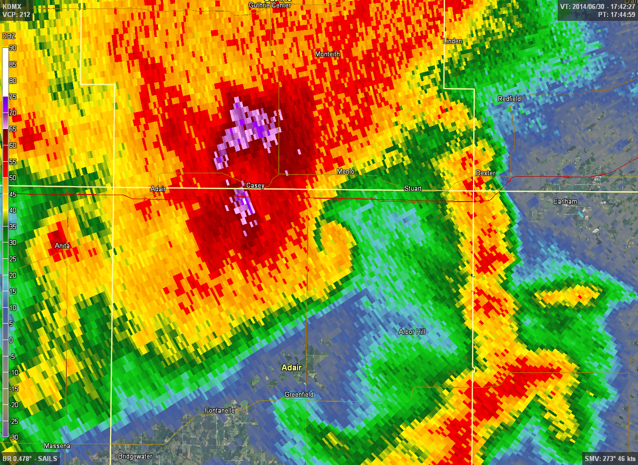
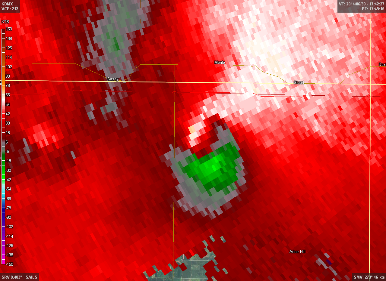
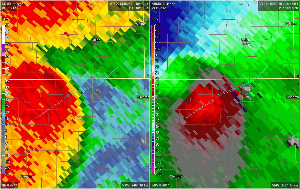
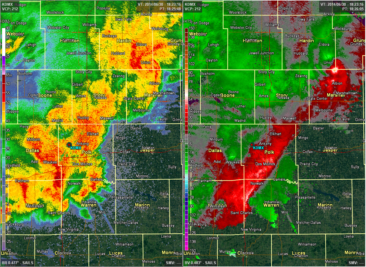
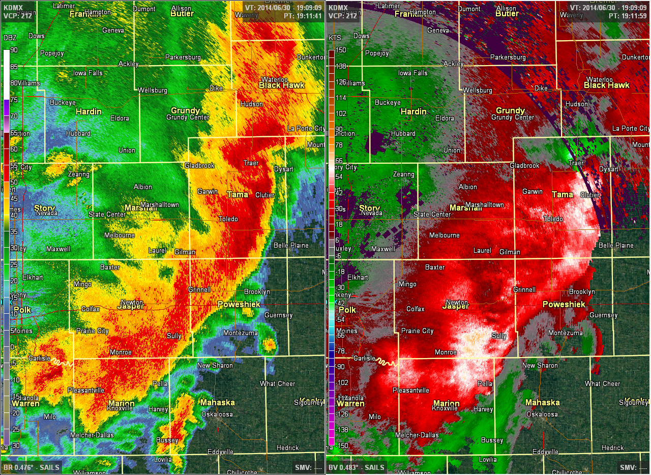
Once the hail core collapsed on the newly developed southwest complex before 1:00pm, it quickly transitioned into a wind threat in eastern Guthrie and Adair counties. Meanwhile, the first squall line caught up with this developing southern line and began to strengthen as well. It was here that the complex rolled through the Des Moines metro, with the strongest winds over Madison and Warren counties but there were sufficient winds to cause some tree damage throughout the metro. Once the line cleared the metro, it rapidly grew upscale into a powerful windstorm as it merged with the northern cell in Tama County. A potent bow echo developed at the merger point by the time the storms reached eastern Tama County and only continued to intensify as it rolled towards Cedar Rapids. Widespread winds of 70-80 kts were measured by the Des Moines WSR-88D radar over eastern Tama County, with similar winds extending southwestward along the line to northern Marion County. This line would accelerate and press eastward across the Mississippi River and reach Chicago by the late afternoon, leaving a trail of widespread wind damage in its wake.
 |
 |
 |
 |
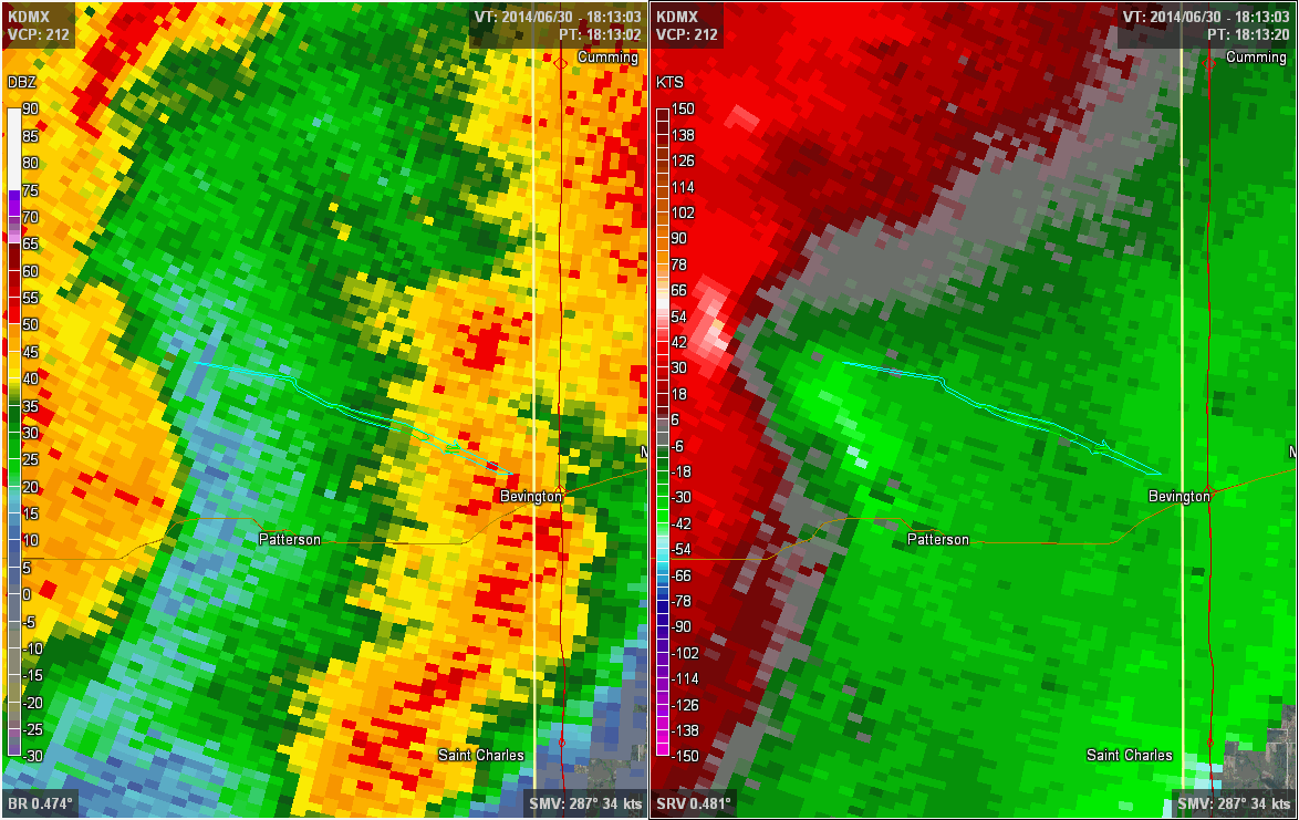
| Base reflectivity (left) and base velocity (right) radar imagery at 11:20am as the first squall line moves into western Crawford County. Note the bow echo signature with winds of 90+ kts measured at 9500 ft punch through to the front of the line. A rear inflow notch is also visible on the reflectivity image. | Base reflectivity (left) and base velocity (right) radar imagery at 11:33am of a discrete cell producing damaging winds over NW Greene and SE Calhoun counties. Winds on velocity are measured at 55-65 kts at 3000 ft. This cell would eventually track into Tama County, where it would merge with the main squall line and produce the Traer tornado. | Base reflectivity (left) and base velocity (right) radar imagery at 12:52pm as the squall line approaches Des Moines. Note that the northern and southern lines have merged and the northern line is starting to re-intensify on velocity over Perry. The wind threat is just starting to get organized in NE Adair and SE Guthrie counties as Tornado #1 dissipates. | Base reflectivity (left) and base velocity (right) radar imagery at 1:26pm as the squall line leaves Des Moines. The line is now catching up with the supercell in SE Hardin County while the strongest winds are from SE Des Moines to east central Madison County. Note that the wind direction is normal to the radar beam, so the winds are poorly sampled by the radar in Des Moines. |
 |
 |
 |
 |
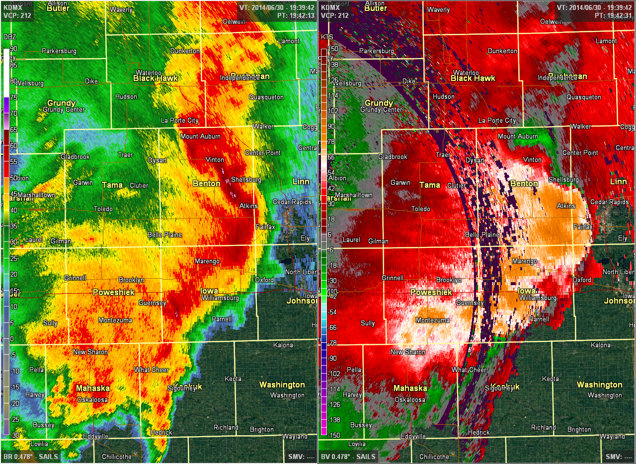
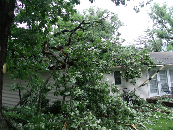
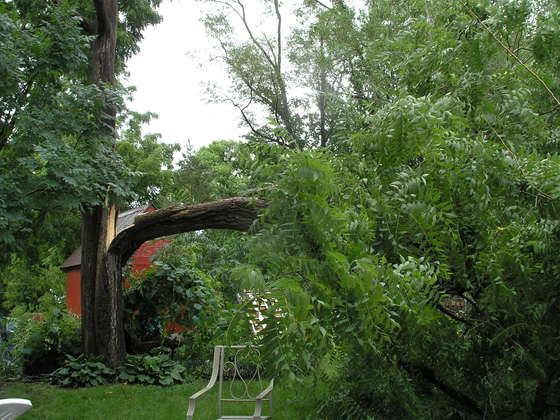
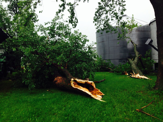
| Base reflectivity (left) and base velocity (right) radar imagery at 2:11pm showing the squall line rapidly intensifying over Tama, Poweshiek, Jasper, and Marion counties. A robust line on reflectivity has replaced the previously fragmented structure and widespread velocities of 60 to 80 kts are being sampled by the radar only a few thousand feet off the ground. | Base reflectivity (left) and base velocity (right) radar imagery at 2:42pm. The line has rapidly developed into a classic bow echo as it accelerates towards Cedar Rapids. A bookend vortex also has developed on the north end of the line in the remnants of the old supercell. A rear inflow jet is also starting to show up punching in through Tama County. Wind velocity values of 70-95 kts are being measured at this point at the apex of the bow. | Tree damage in Newton. Photo Courtesy of the KCCI uLocal page. Uploaded by the public. |
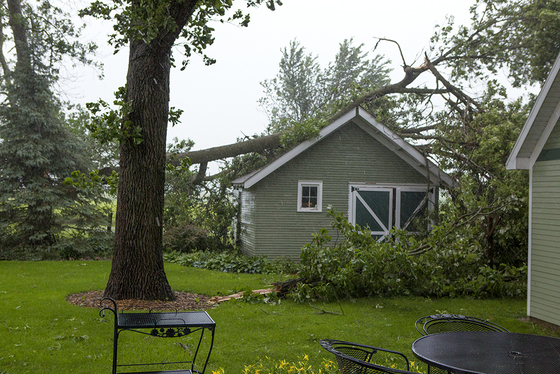
A large section of tree on a shed in Roland. Photo Courtesy of the KCCI uLocal page. Uploaded by the public. |
 |
 |
 |
 |
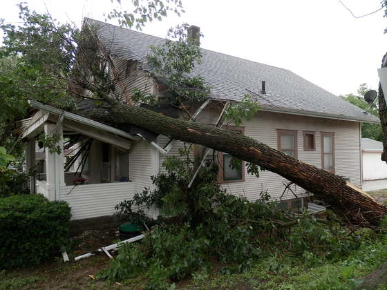
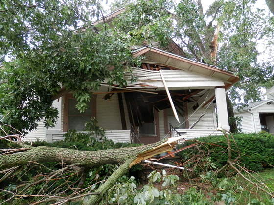
| A large tree crushed a porch in Pella. Photo Courtesy of the KCCI uLocal page. Uploaded by the public. |
A large tree crushed a porch in Pella. Photo Courtesy of the KCCI uLocal page. Uploaded by the public. |
A large tree split in southeast Des Moines. Photo Courtesy of the KCCI uLocal page. Uploaded by the public. |
Large tree branches downed southwest of Story City. Photo Courtesy of the KCCI uLocal page. Uploaded by the public. |
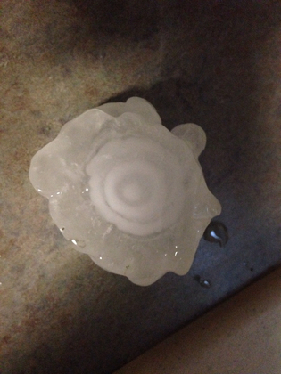
Hail
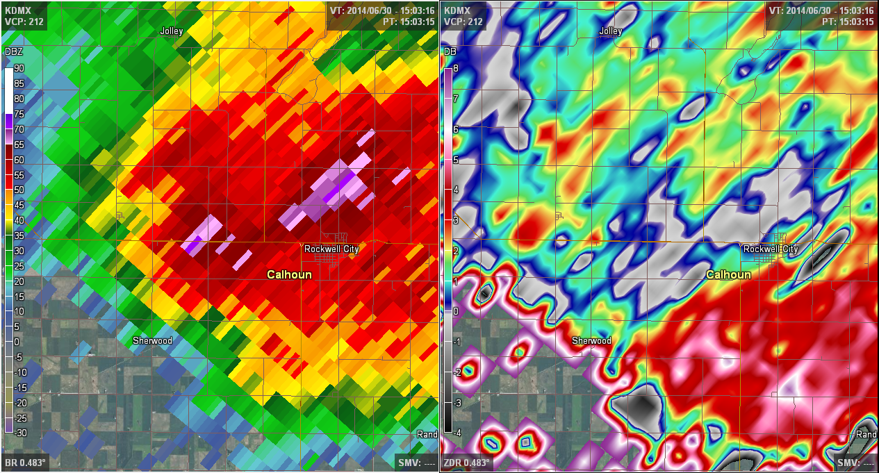
Multiple supercell thunderstorms formed during the early to middle stages of the event and unleashed dangerously large hail over parts of western Iowa. One northern cell tracked across Sac, Calhoun, and Webster counties between 9:00am and 11:00am, dropping hail close to the size of baseballs on Rockwell City and tennis ball size hail on Fort Dodge. This hail smashed car windshields and damaged roofs in both towns. A second supercell ongoing at the same time to the south plotted a course from Harrison County to northern Boone County before merging with another cell and transitioning into a wind/tornado threat, with hail as large a golf balls falling from this storm. Finally, a third massive supercell developed over Audubon, Cass, Adair, and Guthrie counties shortly after 12:00pm and proceeded to drop wind-driven golf ball size hail over a wide swath of prime farm land.
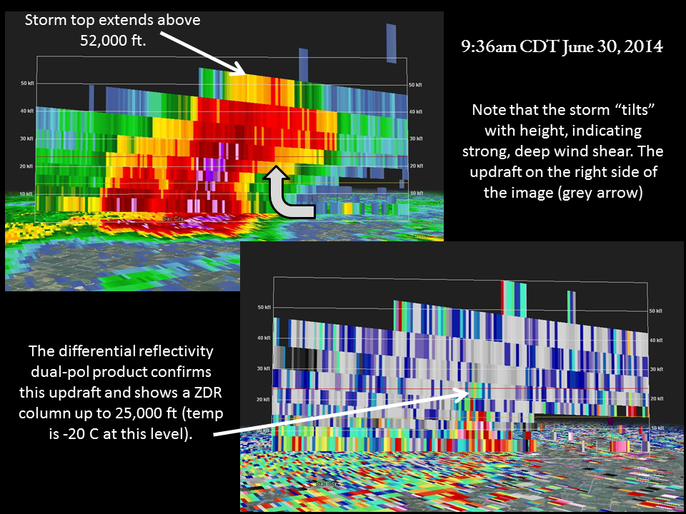
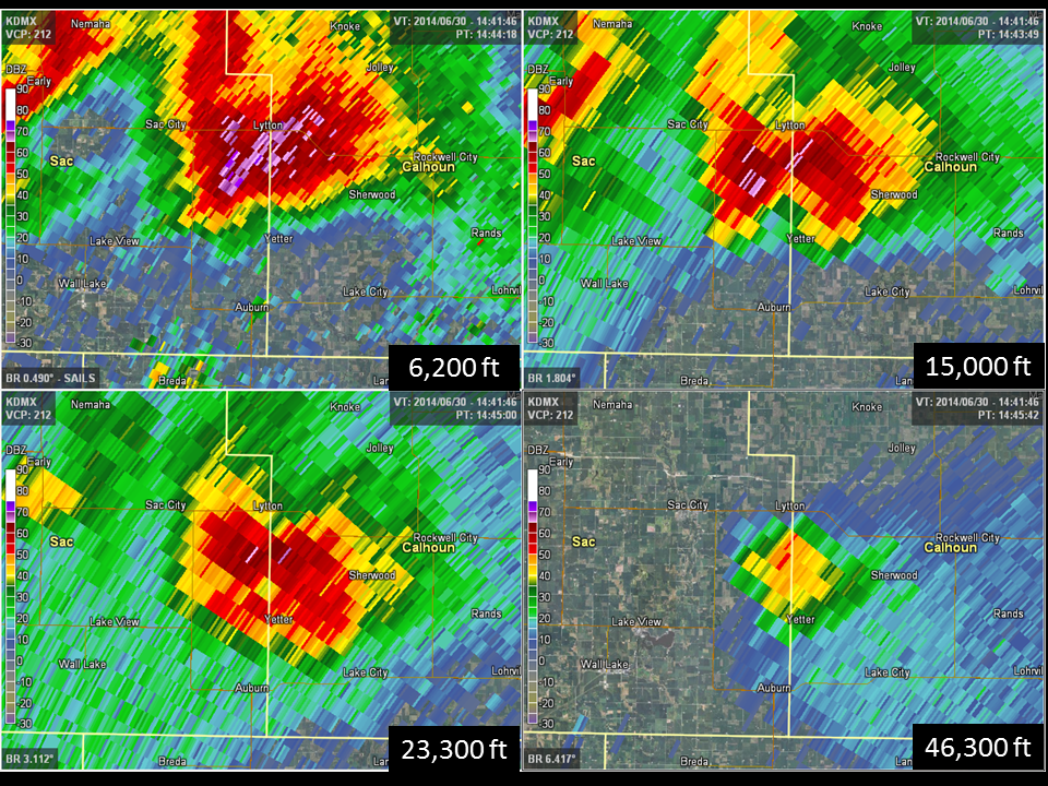
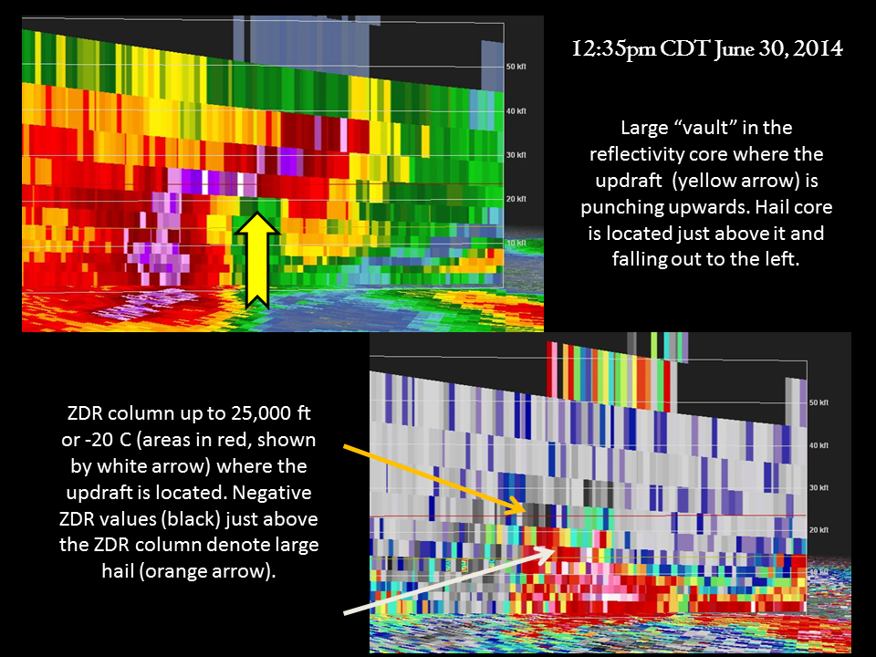
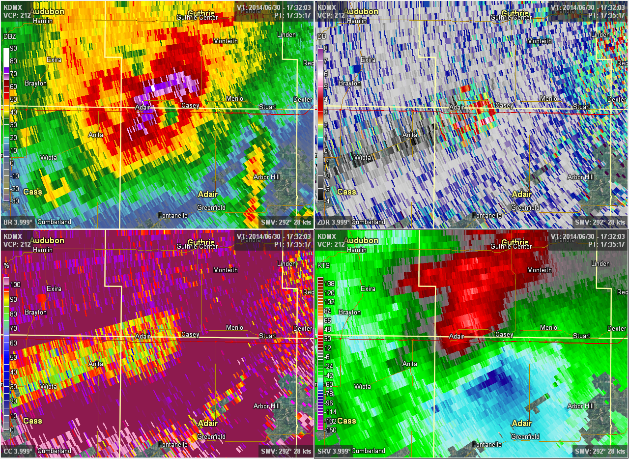
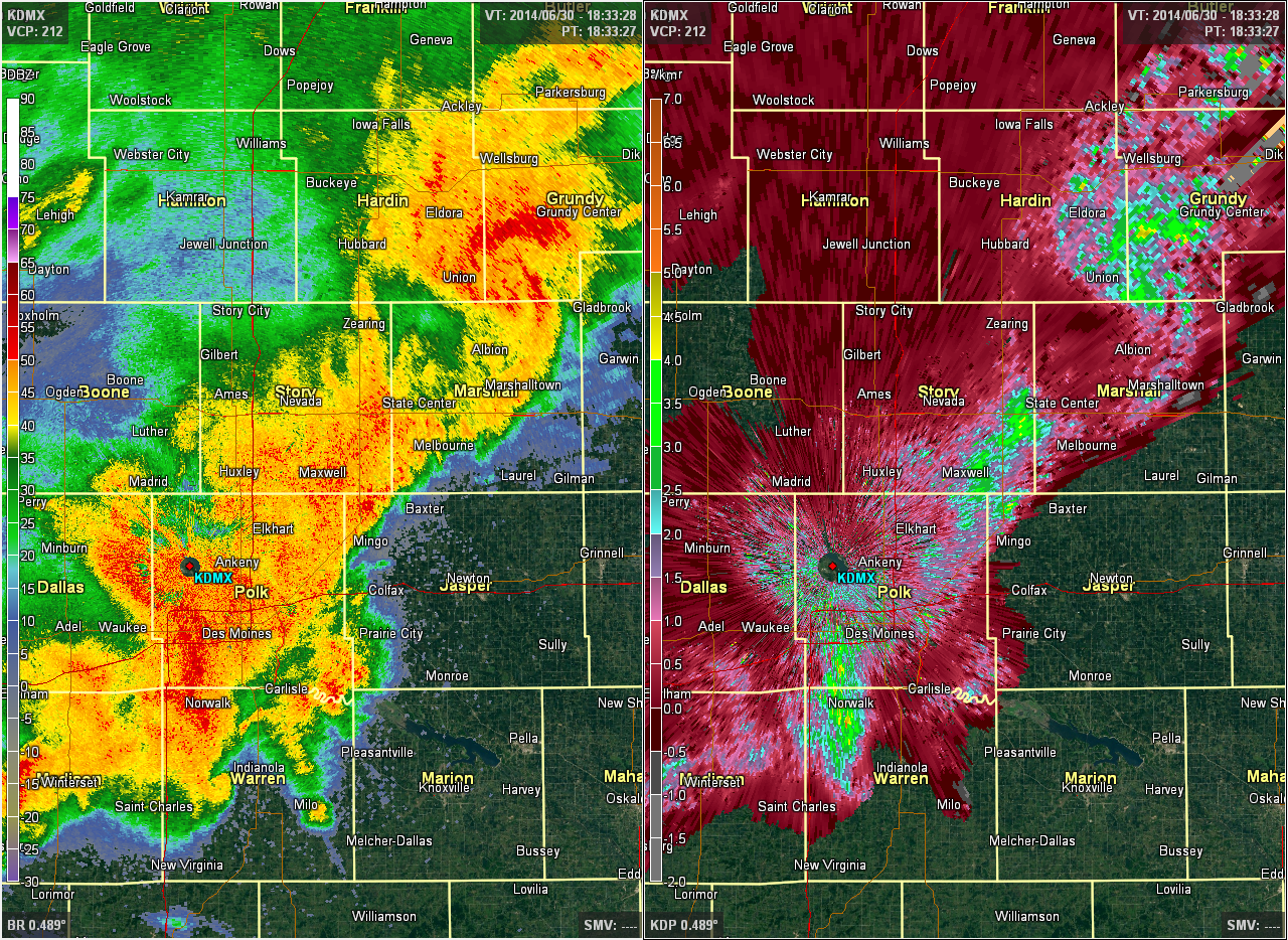
All three storms exhibited impressive structure and characteristics normally seen with storms over Texas, Oklahoma and Kansas. The northern supercell extended up to 52,000 ft in the atmosphere (with a sustained core of 50+ dBZ to 46,000 ft) with a ZDR column that reached up to 25,000 ft high (freezing level was 13,000 ft). A ZDR column is an area of higher differential reflectivity values well above the freezing level that denote the presence of liquid water drops being lofted by the storm's updraft. The higher the ZDR column, the stronger the updraft and the higher the hail producing potential. Meanwhile, the second cell to the south sported a very classic supercell structure with a persistent RFD (which generates the telltale "hook echo") that lasted for much of its life. Both the first and third supercells developed features known as bounded weak echo regions (BWERs) in their mid levels, a key tip off that the storm's updraft is quite strong and capable of producing massive hail. The latter supercell in particular was well sampled by the WSR-88D radar in Des Moines, with radar cross sections easily resolving a large BWER juxtaposed on a tall ZDR column just below a large hail core. The radar images below highlight some of the defining characteristics of these storms, followed by several public photos of the resultant hail.
 |
 |
 |
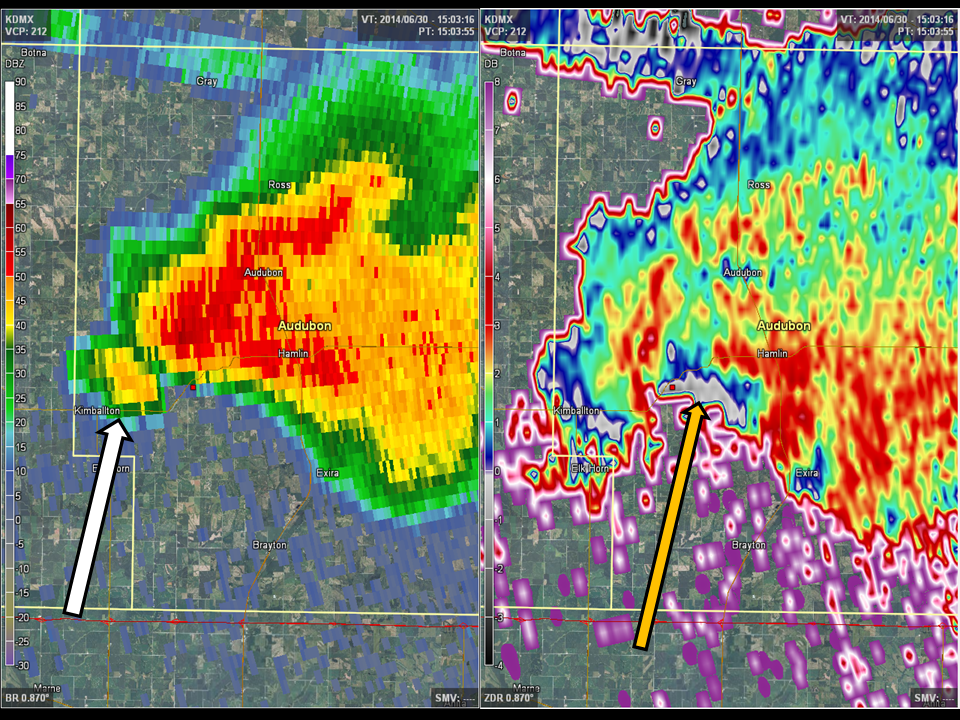 |
| Radar cross sections of the first supercell in northwest Iowa when it was by Sac City. It clearly shows the highly sheared updraft and ZDR column. | Four panel radar image showing the vertical reflectivity structure of the first supercell over Sac and Calhoun counties, extending above 46,000 ft. Also note the BWER on the bottom left image. | Base reflectivity and ZDR imagery of the first supercell over Rockwell City as it was producing 4 inch hail in the city. Note the depressed (grey) ZDR values on the right image, indicative of large hail falling out. | Base reflectivity and ZDR of the second, classic supercell that moved through central Iowa. The white arrow denotes the RFD and the orange arrow highlights the small but still potent hail core on the southern flank of the storm next to the updraft. |
 |
 |
 |
 |
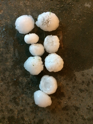
| Cross sections of the third supercell in southwestern Iowa, showing the huge vaulted updraft and ZDR column. Also note the large hail core just above the ZDR column and on the left side of each cross section. | Mid-level view of the third supercell at about 15,000 ft, showing the BWER on reflectivity, a ZDR column in the middle of the BWER, a large hail spike down radial of the core on CC, and a large rotating mesocyclone on SRM. | Multi-layered hail in Rockwell City. Photo Courtesy of the KCCI uLocal page. Uploaded by the public. |
Baseball sized hail that fell in Rockwell City. Photo Courtesy of the KCCI uLocal page. Uploaded by the public. |
 |
 |
 |
 |
| Golf ball to tennis ball sized hail that fell south of Stratford from the southern-most of the first two supercells. Photo Courtesy of the KCCI uLocal page. Uploaded by the public. |
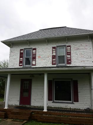
A house damaged by wind-driven hail in Adair County. Photo Courtesy of the KCCI uLocal page. Uploaded by the public. |
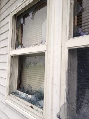
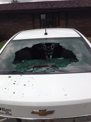
House windows destroyed by wind-driven hail in Casey. Photo Courtesy of the KCCI uLocal page. Uploaded by the public. |
Car windshield broken out in Rockwell City. Photo Courtesy of the KCCI uLocal page. Uploaded by the public. |
Flooding
On top of the damaging winds, large hail, and tornadoes, these storms produced copious amounts of rain in a very short time span that simply could not be handled by the already saturated ground. Rainfall easily exceeded 2-3 inches per hour and many locations picked up 1-2 inches of rain in the first half hour of the event. The first round of excessive rainfall occurred as multiple rounds of storms tracked across Sac and Calhoun counties. The flash flood threat then shifted southward to two main swaths--one from northern Boone county to Black Hawk county, and another from Adair County eastward, through Des Moines, and through east central Iowa. A widespread 2-3 inches of rain fell in central Iowa with 3-5 inches common further east. A few spots even eclipsed the 6 inch mark for the day in east central Iowa (e.g. Iowa City). The resultant flash flooding washed out many roads and tragically led to one death in Cedar Rapids.

Rainfall Map for June 30, showing a widespread swath of 2-3 inches of rain with some locations approaching 6 inches.
Radar/Photos
 |
 |
 |
 |
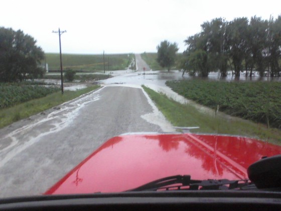
| A washed out road in Adair County. Photo Courtesy of the KCCI uLocal page. Uploaded by the public. |
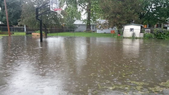
Backyards flooding in Ankeny. Photo Courtesy of the KCCI uLocal page. Uploaded by the public. |
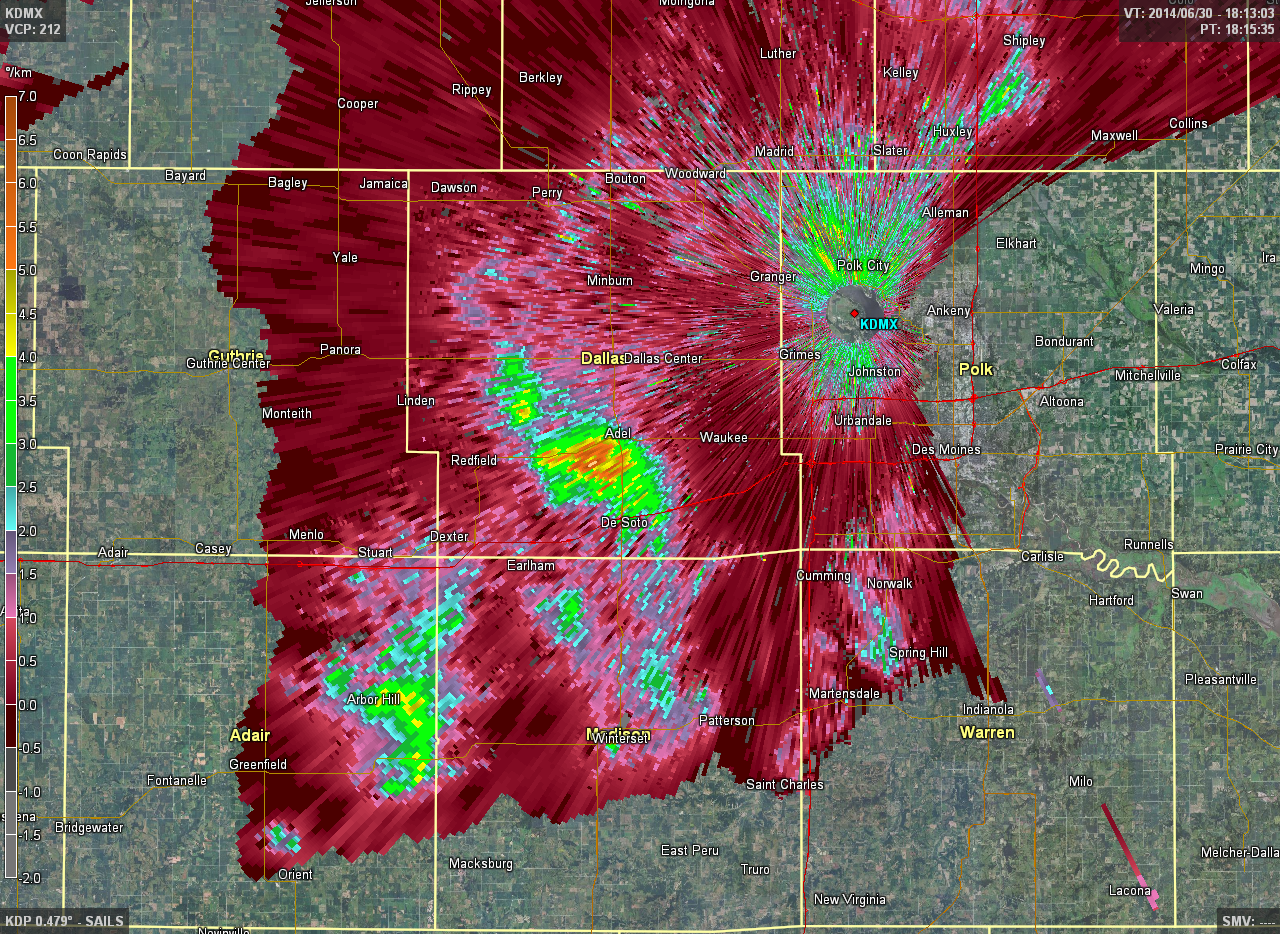
KDP, or specific differential phase, measures the attenuation difference between the horizontal and vertical channels of the radar beam through precipitation. The higher the difference, the larger the raindrops. KDP can thus help locate areas of high rainfall rates. In this image, multiple waves of very efficient rainfall producing storms were moving through NW Des Moines. | KDP (right image) helped locate the areas of higher rainfall rates that might not have been as obvious on conventional reflectivity imagery. |
Storm Reports
...TIME... ...EVENT... ...CITY LOCATION... ...LAT.LON...
...DATE... ....MAG.... ..COUNTY LOCATION..ST.. ...SOURCE....
..REMARKS..
0645 AM HEAVY RAIN ROCKWELL CITY 42.40N 94.63W
06/30/2014 M2.20 INCH CALHOUN IA MESONET
ESTIMATED TO HAVE FALLEN IN 1.5 HOURS BASED
ON RADAR.
0700 AM HEAVY RAIN SAC CITY 42.42N 95.00W
06/30/2014 M2.20 INCH SAC IA CO-OP OBSERVER
ESTIMATED TO HAVE FALLEN MOSTLY BETWEEN 4 AM
AND 7 AM.
0700 AM HEAVY RAIN 1 N ROCKWELL CITY 42.41N 94.63W
06/30/2014 M2.65 INCH CALHOUN IA CO-OP OBSERVER
ESTIMATED TO HAVE FALLEN MOSTLY IN THE LAST
TWO TO THREE HOURS.
1003 AM HAIL ROCKWELL CITY 42.40N 94.63W
06/30/2014 E3.00 INCH CALHOUN IA TRAINED SPOTTER
1005 AM HAIL 5 SW LOHRVILLE 42.21N 94.61W
06/30/2014 E1.00 INCH CALHOUN IA TRAINED SPOTTER
1006 AM HAIL ROCKWELL CITY 42.40N 94.63W
06/30/2014 E2.00 INCH CALHOUN IA TRAINED SPOTTER
SPOTTER CH119
1007 AM HAIL ROCKWELL CITY 42.39N 94.64W
06/30/2014 E2.00 INCH CALHOUN IA TRAINED SPOTTER
SPOTTER CH210
1010 AM HAIL ROCKWELL CITY 42.40N 94.63W
06/30/2014 E1.75 INCH CALHOUN IA LAW ENFORCEMENT
CALHOUN CO. SHERIFF
1011 AM HAIL ROCKWELL CITY 42.40N 94.63W
06/30/2014 E4.00 INCH CALHOUN IA TRAINED SPOTTER
SPOTTER CH119
1043 AM HAIL FORT DODGE 42.51N 94.18W
06/30/2014 E1.50 INCH WEBSTER IA AMATEUR RADIO
1044 AM HAIL FORT DODGE 42.51N 94.17W
06/30/2014 E1.50 INCH WEBSTER IA TRAINED SPOTTER
SPOTTER WE118
1045 AM HAIL FORT DODGE 42.51N 94.18W
06/30/2014 M1.75 INCH WEBSTER IA TRAINED SPOTTER
GOLF BALL HAIL IN FORT DODGE.
1046 AM HAIL FORT DODGE 42.51N 94.18W
06/30/2014 E1.00 INCH WEBSTER IA LAW ENFORCEMENT
CEDAR FALLS STATE PATROL
1048 AM HAIL FORT DODGE 42.51N 94.18W
06/30/2014 E2.50 INCH WEBSTER IA TRAINED SPOTTER
SPOTTER WE239
1050 AM HAIL 2 S FORT DODGE 42.48N 94.18W
06/30/2014 E2.00 INCH WEBSTER IA BROADCAST MEDIA
WHO-TV REPORTED.
1052 AM HAIL 1 WNW FORT DODGE 42.51N 94.19W
06/30/2014 E2.00 INCH WEBSTER IA TRAINED SPOTTER
SPOTTER WE211
1125 AM TSTM WND DMG DENISON 42.02N 95.35W
06/30/2014 CRAWFORD IA EMERGENCY MNGR
MULTIPLE TREE-LIMBS DOWN AND WINDS ESTIMATED
AT 60 TO 70 MPH.
1136 AM HAIL GRAND JUNCTION 42.03N 94.24W
06/30/2014 E1.00 INCH GREENE IA AMATEUR RADIO
1141 AM HAIL 2 W OGDEN 42.04N 94.07W
06/30/2014 E1.50 INCH BOONE IA EMERGENCY MNGR
1146 AM HAIL 2 NW OGDEN 42.06N 94.05W
06/30/2014 E1.00 INCH BOONE IA TRAINED SPOTTER
BN109 SPOTTER REPORT VIA WEB LSR FORM.
1147 AM HAIL 3 S ODEBOLT 42.27N 95.25W
06/30/2014 M1.75 INCH SAC IA FIRE DEPT/RESCUE
ODEBOLDT FIRE REPORTED GOLF BALL HAIL SOUTH
OF TOWN AND 60 TO 70 MPH WIND GUSTS IN TOWN.
1150 AM TSTM WND GST 5 W GOWRIE 42.27N 94.38W
06/30/2014 E70 MPH WEBSTER IA TRAINED SPOTTER
SPOTTER WE421
1150 AM TSTM WND GST 5 W GOWRIE 42.28N 94.39W
06/30/2014 E60 MPH WEBSTER IA TRAINED SPOTTER
WE421
1152 AM HAIL 1 S BOXHOLM 42.16N 94.11W
06/30/2014 E1.75 INCH BOONE IA EMERGENCY MNGR
1202 PM TSTM WND GST OTTOSEN 42.90N 94.38W
06/30/2014 E50 MPH HUMBOLDT IA TRAINED SPOTTER
1205 PM TSTM WND DMG 5 ESE EXIRA 41.56N 94.78W
06/30/2014 AUDUBON IA PUBLIC
SECOND HAND REPORT OF WIND DAMAGE AT
LITTLEFIELD RECREATION AREA. TIME ESTIMATED
VIA RADAR.
1213 PM HAIL STRATFORD 42.27N 93.93W
06/30/2014 E1.25 INCH HAMILTON IA TRAINED SPOTTER
1214 PM HAIL BOXHOLM 42.17N 94.11W
06/30/2014 E1.75 INCH BOONE IA EMERGENCY MNGR
BOONE EM REPORTS GOLFBALL SIZE HAIL AND
STRONG WINDS IN BOXHOLM. TREE BRANCHES
COMING DOWN.
1230 PM HAIL ADAIR 41.50N 94.64W
06/30/2014 E2.50 INCH ADAIR IA EMERGENCY MNGR
EMERGENCY MANAGER REPORTED AROUND 300 HOMES
DAMAGED FROM LARGE WIND DRIVEN HAIL.
NUMEROUS TREES DAMAGED. NUMEROUS CARS ON I80
HAD THEIR WINDOWS BROKEN
1231 PM HAIL ADAIR 41.50N 94.64W
06/30/2014 E1.50 INCH ADAIR IA EMERGENCY MNGR
ALSO 40 TO 50 MPH WINDS IN TOWN OF ADAIR.
1234 PM HAIL 3 S STRATFORD 42.23N 93.93W
06/30/2014 E1.75 INCH HAMILTON IA LAW ENFORCEMENT
1236 PM HEAVY RAIN 5 W GOWRIE 42.27N 94.38W
06/30/2014 E1.13 INCH WEBSTER IA TRAINED SPOTTER
1.13 INCHES OF RAIN IN 45 MINUTES.
1241 PM HAIL 1 SE ADAIR 41.49N 94.63W
06/30/2014 E1.75 INCH ADAIR IA LAW ENFORCEMENT
GOLF BALL ON I80 MILE MARKER 77 DAMAGE TO
CARS AND WINDOWS
1244 PM TSTM WND GST 2 SW STORY CITY 42.17N 93.62W
06/30/2014 E70 MPH STORY IA STORM CHASER
65 TO 75 MPH ESTIMATED GUST FROM THE
SPOTTERNETWORK.ORG
1245 PM TSTM WND GST 3 S STUART 41.46N 94.32W
06/30/2014 E60 MPH ADAIR IA TRAINED SPOTTER
REPORT VIA THE LSR WEB REPORT FORM.
1245 PM TSTM WND DMG RANDALL 42.24N 93.60W
06/30/2014 HAMILTON IA STORM CHASER
AT LEAST 2 TREES, 1 POWER POLE, AND
WIDESPREAD LARGE TREE LIMBS DOWN ACROSS
RANDALL.
1247 PM TORNADO 5 S STUART 41.43N 94.32W
06/30/2014 ADAIR IA BROADCAST MEDIA
APPARENT TORNADO DAMAGE TO HOME FROM WHO-TV.
1250 PM HAIL 1 SE ELLSWORTH 42.30N 93.57W
06/30/2014 E0.88 INCH HAMILTON IA TRAINED SPOTTER
1254 PM TSTM WND DMG 2 SSW RANDALL 42.21N 93.62W
06/30/2014 HAMILTON IA STORM CHASER
TREES SNAPPED OFF AT BASES AND LARGE LIMBS
ACROSS US 69 HIGHWAY. SPOTTERNETWORK.ORG VIA
NWSCHAT.
1254 PM TSTM WND DMG ZEARING 42.16N 93.30W
06/30/2014 STORY IA EMERGENCY MNGR
NUMEROUS 40 TO 50 FEET TALL TREES DOWN IN
ZEARING. LARGE TREE BRANCH ACROSS HIGHWAY 69
1 MILE SOUTH OF STATE ROAD E29. REPORT FROM
EM VIA NWSCHAT.
0107 PM HAIL ESE HUBBARD 42.30N 93.29W
06/30/2014 E1.00 INCH HARDIN IA TRAINED SPOTTER
TRAINED SPOTTER REPORTS DIME TO QUARTER
SIZED HAIL...CONSIDERABLE WIND AND HEAVY
RAIN.
0110 PM TSTM WND GST 1 S HUBBARD 42.28N 93.30W
06/30/2014 M81 MPH HARDIN IA MESONET
MEASURED BY HOME WEATHER STATION. TWO LARGE
ASH TREES SNAPPED. PINE TREE SNAPPED. CORN
AND BEAN CROPS FLATTENED.
0115 PM HAIL 2 W ADEL 41.61N 94.07W
06/30/2014 E1.00 INCH DALLAS IA EMERGENCY MNGR
0116 PM TSTM WND DMG URBANDALE 41.64N 93.74W
06/30/2014 POLK IA PUBLIC
MEDIUM SIZE TREE LIMB DAMAGE
0118 PM HAIL 1 W NEW PROVIDENCE 42.28N 93.19W
06/30/2014 E1.00 INCH HARDIN IA EMERGENCY MNGR
ALSO A LARGE TREE ACROSS A ROAD AT THIS
LOCATION DUE TO STRONG (UNKNOWN SPEED) WIND.
0120 PM TSTM WND DMG LISCOMB 42.19N 93.01W
06/30/2014 MARSHALL IA EMERGENCY MNGR
LARGE MACHINE SHED DOWN. NUMEROUS REPORTS OF
TREES DOWN ACROSS NORTHERN MARSHALL COUNTY
INCLUDING IN CLEMONS AND ALBION. TIME FOR
THE LISCOMB REPORT ESTIMATED BY RADAR
0120 PM TSTM WND DMG 1 SE BEVINGTON 41.35N 93.78W
06/30/2014 WARREN IA EMERGENCY MNGR
SEMI-TRUCK BLOWN OVER ON I-35 AT THIS
LOCATION.
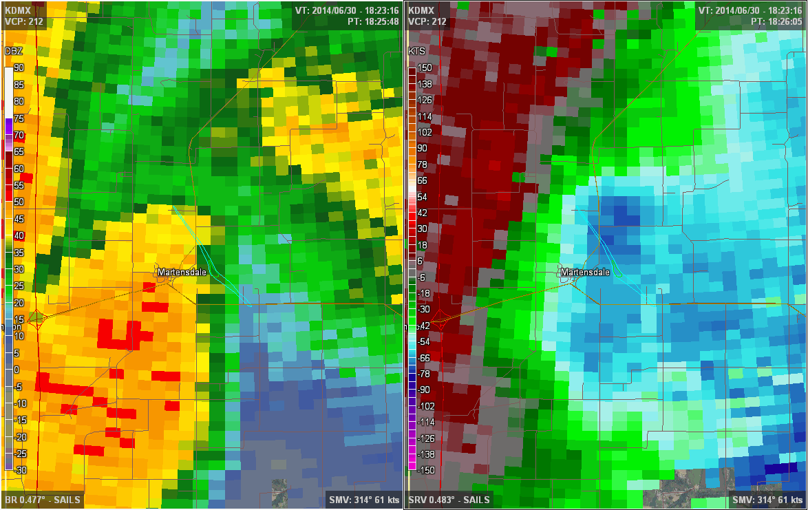
0122 PM FUNNEL CLOUD MARTENSDALE 41.37N 93.74W
06/30/2014 WARREN IA PUBLIC
FUNNEL LASTED LESS THAN 1 MINUTE AND RECEDED
INTO CLOUDS
0125 PM TSTM WND DMG 2 S MARTENSDALE 41.34N 93.73W
06/30/2014 WARREN IA EMERGENCY MNGR
3195 KIRKWOOD ST., PROLE, IA... LARGE GRAIN
BIN DESTROYED ALONG WITH TWO HOOP BUILDINGS.
TIME EST. FROM RADAR FROM NWSCHAT POSTING
FROM WARREN CO. EMA.
0125 PM TSTM WND DMG 1 ESE MARTENSDALE 41.37N 93.71W
06/30/2014 WARREN IA EMERGENCY MNGR
BUILDING AND HOUSE PARTIALLY DESTROYED 50TH
AVENUE AND HIGHWAY 92, VIA NWSCHAT.
0127 PM TSTM WND GST 1 W CUMMING 41.48N 93.78W
06/30/2014 E70 MPH WARREN IA STORM CHASER
SPOTTERNETWORK.ORG VIA NWSCHAT.
0128 PM TSTM WND DMG 1 N MARTENSDALE 41.39N 93.74W
06/30/2014 WARREN IA EMERGENCY MNGR
BARN DESTROYED BY WIND.
0128 PM TSTM WND DMG MARTENSDALE 41.37N 93.74W
06/30/2014 WARREN IA EMERGENCY MNGR
ALL WINDOWS BROKEN OUT OF HOUSE AT THIS
LOCATION. EM VIA NWSCHAT.
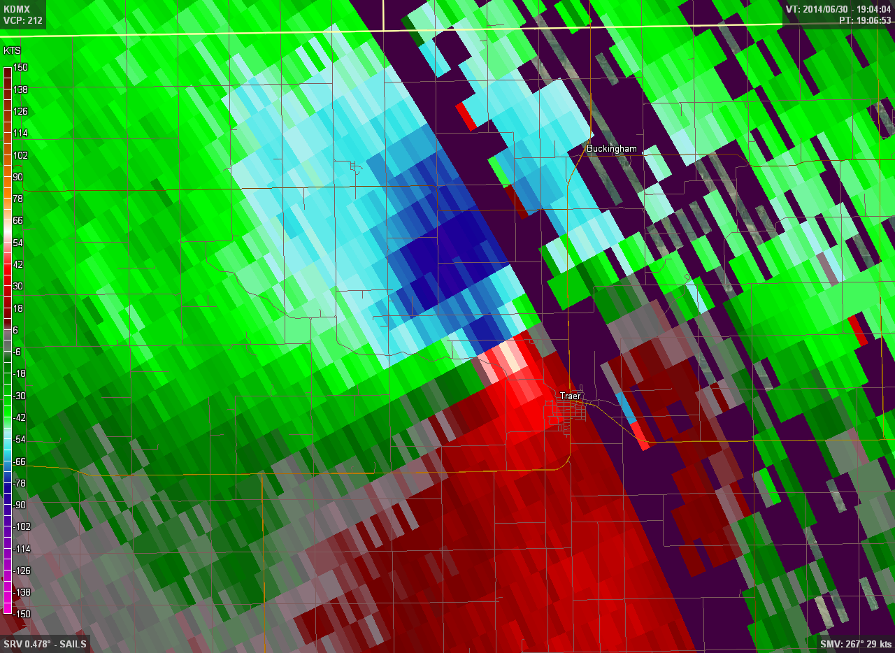
0130 PM TORNADO TRAER 42.19N 92.46W
06/30/2014 TAMA IA FIRE DEPT/RESCUE
TRAER FIRE DEPT. REPORTS SEVERAL HOMES
DAMAGED OR DESTROYED IN TRAER.
0130 PM TSTM WND GST MARTENSDALE 41.37N 93.74W
06/30/2014 E70 MPH WARREN IA PUBLIC
0135 PM TSTM WND DMG 2 NNW GRIMES 41.69N 93.80W
06/30/2014 POLK IA TRAINED SPOTTER
SMALL TREES REPORTED UPROOTED. DITCH
FLOODING AROUND BRIARCREEK HOUSING
DEVELOPMENT
0140 PM HAIL GRUNDY CENTER 42.36N 92.77W
06/30/2014 E0.88 INCH GRUNDY IA TRAINED SPOTTER
SPOTTER ESTIMATES WIND GUST 40 MPH
0140 PM TSTM WND DMG MARTENSDALE 41.37N 93.74W
06/30/2014 WARREN IA EMERGENCY MNGR
POWERLINES DOWN ON HIGHWAY 28 JUST NORTH OF
MARTENSDALE AND TREE LIMBS DOWN ON HOUSE IN
MARTENSDALE. EM REPORT VIA NWSCHAT.
0141 PM HAIL NORWALK 41.50N 93.68W
06/30/2014 M1.00 INCH WARREN IA TRAINED SPOTTER
HEAVY RAINFALL ALSO OCCURING AT THIS TIME
CAUSING PONDING OF WATER.
0141 PM TSTM WND GST 1 WSW INDIANOLA 41.36N 93.58W
06/30/2014 E60 MPH WARREN IA FIRE DEPT/RESCUE
ESTIMATED 60 MPH WIND, HEAVY RAIN AND SMALL
LIMBS DOWN. INDIANOLA FD VIA MICRN.
0147 PM FLASH FLOOD ANKENY 41.72N 93.61W
06/30/2014 POLK IA TRAINED SPOTTER
WATER OVER CURBS AND FLOWING. 9TH ST AND
DELAWARE IN ANKENY.
0148 PM TSTM WND GST 3 S GRUNDY CENTER 42.32N 92.77W
06/30/2014 E70 MPH GRUNDY IA LAW ENFORCEMENT
SHERIFF DEPUTY ESTIMATED AT LEAST 70 MPH
WINDS AND PEA SIZE HAIL AT 229TH AND 260TH
0153 PM TSTM WND DMG SANDYVILLE 41.37N 93.39W
06/30/2014 WARREN IA EMERGENCY MNGR
ALL WINDOWS ON NORTH SIDE OF HOUSE
DESTROYED. LIKELY WIND AND HAIL DAMAGE BOTH.
TIME ESTIMATED FROM RADAR. NWSCHAT REPORT
FROM EMA.
0153 PM HAIL SANDYVILLE 41.37N 93.39W
06/30/2014 E2.75 INCH WARREN IA EMERGENCY MNGR
DELAYED REPORT FROM EM VIA NWSCHAT. GOLFBALL
TO BASEBALL SIZED HAIL.
0156 PM TSTM WND DMG TRAER 42.19N 92.46W
06/30/2014 TAMA IA CO-OP OBSERVER
HALF OF ROOF BLOWN OFF.
0157 PM FLASH FLOOD 2 NNW GRIMES 41.69N 93.80W
06/30/2014 POLK IA AMATEUR RADIO
6 INCHES OR MORE OF WATER, RAPIDLY MOVING,
IN AREAS IT TYPICALLY DOES NOT OCCUR. 2.5
INCHES OF RAIN IN 45 MINUTES. LITTLE BEAVER
CREEK OUT OF BANKS
0202 PM TSTM WND GST PLEASANTVILLE 41.39N 93.27W
06/30/2014 E60 MPH MARION IA TRAINED SPOTTER
SPOTTER MN402 ALSO NICKEL HAIL IN THIS
GENERAL LOCATION VIA THE PHONE.
0210 PM TSTM WND DMG TRAER 42.19N 92.46W
06/30/2014 TAMA IA BROADCAST MEDIA
KCVM...KCNZ... KCFI REPORT VIA NWSCHAT WITH
TIME ESTIMATED FROM RADAR REPORTING DAMAGE
IN TRAER...TREES OVER POWER LINES, SEMI
TRAILER TIPPED OVER AND DAMAGE TO HOUSES.
REPORT VIA NWSCHAT.
0210 PM TSTM WND GST 8 WNW LA PORTE CITY 42.34N 92.34W
06/30/2014 E60 MPH BLACK HAWK IA TRAINED SPOTTER
SPOTTER BH410 VIA PHONE. ALSO 1.25 INCHES OF
RAIN FROM AROUND 2:10 PM TO 2:35 PM.
0217 PM TSTM WND DMG CHELSEA 41.92N 92.40W
06/30/2014 TAMA IA FIRE DEPT/RESCUE
CORN CRIB DESTROYED BY HIGH WINDS. DELAYED
REPORT FROM CHELSEA F.D.
0217 PM TSTM WND GST 1 S GRUNDY CENTER 42.35N 92.77W
06/30/2014 E70 MPH GRUNDY IA FIRE DEPT/RESCUE
ESTIMATED 70 MPH WINDS IN AND JUST SOUTH OF
CHELSEA ALONG WITH TORRENTIAL RAIN. POWER
LINES DOWN, A LOT OF TREE DAMAGE IN CHELSEA.
0225 PM TSTM WND DMG LA PORTE CITY 42.31N 92.19W
06/30/2014 BLACK HAWK IA EMERGENCY MNGR
BLACK HAWK COUNTY EMERGENCY MANAGER REPORTS
TREE AND CROP DAMAGE. TIME ESTIMATED BY
RADAR.
0230 PM HEAVY RAIN 1 E HARTFORD 41.46N 93.39W
06/30/2014 M1.60 INCH WARREN IA TRAINED SPOTTER
HEAVY RAIN DURATION 1 HOUR OBSERVER LOCATION
HARTFORD
0230 PM TSTM WND DMG DUNKERTON 42.57N 92.16W
06/30/2014 BLACK HAWK IA PUBLIC
TREES AND POWERLINES DOWN IN TOWN. IMAGES
RELAYED BY KWWL. TIME ESTIMATED FROM RADAR
0259 PM HEAVY RAIN 4 SW DUNKERTON 42.53N 92.22W
06/30/2014 M2.00 INCH BLACK HAWK IA TRAINED SPOTTER
BH206 SPOTTER REPORT OF 2.0 INCHES OF RAIN
IN 20 MINUTES.
0349 PM FLASH FLOOD CONRAD 42.22N 92.87W
06/30/2014 GRUNDY IA LAW ENFORCEMENT
GRUNDY COUNTY LAW ENFORCEMENT REPORTS
NUMEROUS CREEKS HAVE RISEN OUT OF THEIR
BANKS AND SEVERAL ROADS ARE UNDERWATER
AROUND THE COUNTY.
0603 PM HAIL 3 SW TAMA 41.93N 92.62W
06/30/2014 E0.88 INCH TAMA IA LAW ENFORCEMENT
0614 PM FLASH FLOOD MARSHALLTOWN 42.04N 92.91W
06/30/2014 MARSHALL IA TRAINED SPOTTER
FAST MOVING WATER OF UNKNOWN DEPTH MOVING
DOWN AN ENTIRE CITY STREET
0620 PM HEAVY RAIN W MANSON 42.53N 94.54W
06/30/2014 E2.80 INCH CALHOUN IA TRAINED SPOTTER
RAINFALL TOTAL FOR TODAY
Environment
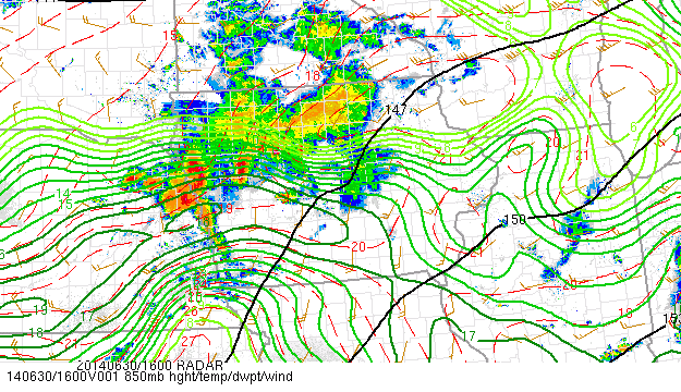
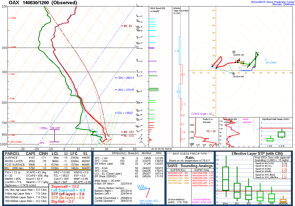
The overall environment was primed for a major severe weather event on the morning of June 30. A sharp upper-level shortwave trough was diving south as it rotated around its parent low in south central Canada. A 60-80 kt zonal jet stream existed upstream of this trough over South Dakota and Minnesota, with a 100 kt jet streak located over Minnesota (Fig. 1). Iowa was situated under the right-rear quadrant of this jet, an ideal location to maximize the synoptic, broad-scale lift provided by this jet streak. Ample low-level moisture was available for ingesting into the storms (850mb Fig. 2) while the 12Z Omaha sounding on June 30 (Fig. 3) revealed a deep elevated mixed layer (EML) from 800 to 600 mb. This pocket of dry air increased the surface-based CAPE (SBCAPE) of the sounding to over 4000 J/kg, more than ample instability to fuel thunderstorm development.
 |
 |
 |
| Figure 1: 300 mb Heights, Winds, and Divergence | Figure 2: 850 mb Heights, Temp, and Dewpoint | Figure 3: Omaha Sounding at 7:00am CDT on 6/30 |
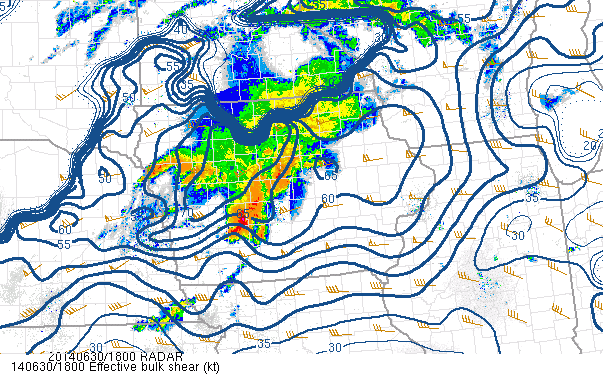
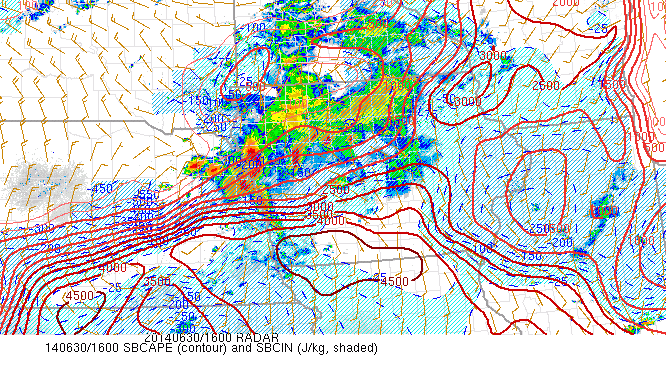
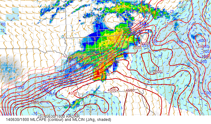
The near-storm environment was just as potent as the synoptic environment. Wind shear throughout the lower to mid troposphere was quite strong, often times in the 50 to 60 kt range (Fig. 4). This change in wind speed/direction enabled the storms to maintain their organization over long periods of time, increasing their severity. The shear also led to updraft rotation in many of the storms which accelerated the growth of hailstones and can aid in tornado formation. Initially the storms were elevated, that is that the updrafts were ingesting instability based not at the surface, but potentially thousands of feet in the atmosphere. Many storms during the overnight and morning hours are elevated due to the presence of a nocturnal inversion. While the threat for damaging winds and tornadoes lessens with elevated storms, these cells can still be prolific hail producers. This was the case with the initial supercells that impacted the state (Fig. 5). Despite 2000-4000 J/kg of CAPE, the inversion was still in place (measured by convective inhibition, or CIN). However, as daytime heating commenced, the inversion at the surface was wiped out and the storms became rooted at the surface (Fig. 6), allowing for the onset of widespread damaging winds and tornadoes.
 |
 |
 |
| Figure 4: Effective Shear (kts) at 1:00pm CDT 6/30 |
Figure 5: Surface-Based CAPE at 11:00am CDT 6/30 |
Figure 6: Mixed-Layer CAPE at 1:00pm CDT 6/30 |
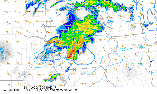
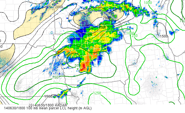
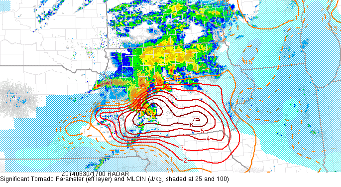
The tornadic environment also became more favorable as the late morning and early afternoon wore on. In addition to the storms becoming surface-based, the low-level helicity, a measure of the potential for updraft rotation (using sounding hodographs), increased from about 50 m2/s2 to 200 m2/s2 by 1:00pm CDT, around the time of the first tornado touchdown (Fig. 7). The lifted condensation level, or LCL, also fell to around 750 m in central Iowa by 1:00pm CDT (Fig. 8). Generally any values less than 1000 m are conducive for tornado development. At the time of the first tornado touchdown around 12:45pm CDT, the significant tornado parameter, which takes all of these aforementioned variables and more to determine the potential for a tornado, was pegged over southwest Iowa, almost precisely where the first tornado touched down (Fig. 9).
 |
 |
 |
| Figure 7: 0-1 km Helicity (m2/s2) at 1:00pm CDT 6/30 |
Figure 8: LCL Height (m) at 1:00pm CDT 6/30 |
Figure 9: Sig Tor Parameter (Eff) at 1:00pm CDT 6/30 |
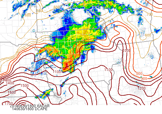
By the mid afternoon, conditions had also become conducive for a widespread, damaging wind event. Values of Downdraft CAPE (DCAPE), which measures the potential negative buoyancy of a parcel, had exceeded 1000 J/kg out ahead of the developing bow echo (Fig. 10). The derecho composite parameter, which uses several variables to predict the likelihood of a widespread, damaging wind event, had risen quite high in the same locations out ahead of the storm (Fig. 11).
 |
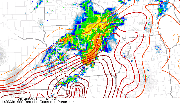 |
| Figure 10: Downdraft CAPE (J/kg) at 1:00pm CDT 6/30 | Figure 11: Downdraft CAPE (J/kg) at 1:00pm CDT 6/30 |
 |
Media use of NWS Web News Stories is encouraged! Please acknowledge the NWS as the source of any news information accessed from this site. |
|