
Tropical Storm Bertha could bring tropical storm conditions to portions of the Florida Panhandle and Alabama coast through Wednesday, where a Tropical Storm Watch and Storm Surge Watch is in effect. Numerous severe thunderstorms with heavy rainfall are expected from the Ohio Valley into the Mid-Atlantic and Northeast Tuesday. Read More >
The winter of 1978-1979 will long be remembered for not only heavy snow, but bitterly cold temperatures. A winter season record of 52.9 inches of snow fell over the area and the average temperature during the winter was a record low of 14.1F.
January 1979 was a record breaking month in terms of both snowfall and arctic cold temperatures. From January 12th to the 14th, a winter storm dumped an estimated 18.4 inches of snow. This was a record amount for a single snowstorm. A record 26.7 inches fell during the month of January, while the snow depth was a record 28 inches from January 14 through the 19th.
Besides being a month for record snow, January was also the coldest month ever in the Quad Cities. The average temperature for the month was only 6.3°F. The second coldest reading ever occurred on January 2nd, when the temperature dropped to 27°F below zero.
.png)
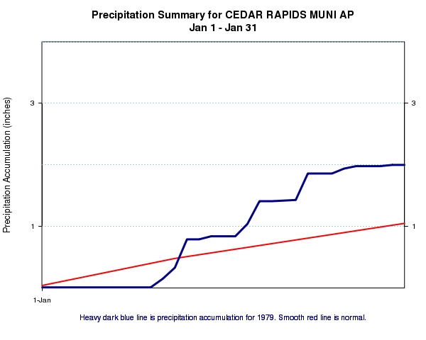 |
| Figure 1: Total January 1979 precipitation (inches) at Cedar Rapids Airport |
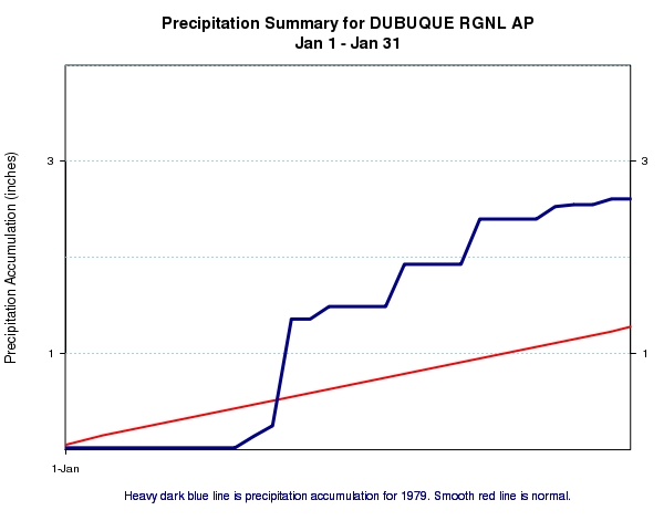 |
| Figure 1: Total January 1979 precipitation (inches) at Dubuque Regional Airport |
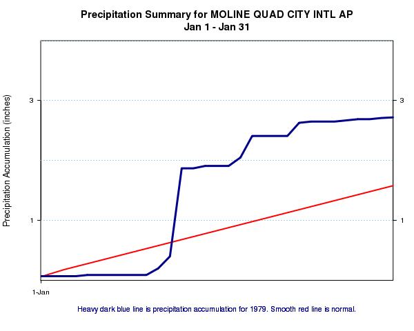 |
| Figure 3: Total January 1979 precipitation (inches) at Moline Quad City Internaltional Airport |
|
Day |
Maximum Temperature (°F) |
Minimum Temperature (°F) |
Snow (inches) |
|
1 |
14 |
- 10 |
1.0 |
|
2 |
- 5 |
- 27 |
0.0 |
|
3 |
3 |
- 14 |
0.0 |
|
4 |
3 |
- 12 |
Trace |
|
5 |
2 |
- 19 |
0.2 |
|
6 |
10 |
- 19 |
0.0 |
|
7 |
10 |
- 7 |
0.0 |
|
8 |
4 |
- 17 |
0.0 |
|
9 |
13 |
- 6 |
0.0 |
|
10 |
5 |
- 18 |
0.0 |
|
11 |
8 |
- 17 |
1.3 |
|
12 |
18 |
7 |
2.3 |
|
13 |
20 |
11 |
14.8 |
|
14 |
11 |
- 21 |
Trace |

