
Scattered thunderstorms with severe gusts, hail and a tornado risk are possible near a cold front from the Ohio Valley to the Mid-Atlantic tonight. Tropical Storm Bertha is expected to bring tropical storm conditions to portions of the Gulf Coast from the panhandle of Florida into Louisiana through Wednesday. Read More >
|
|
|
Ice covering a stop sign in Blue Grass, IA (Photo courtesy of Donna Dubberke, NWS Quad Cities Warning Coordination Meteorologist) |
A large area of freezing rain developed with embedded thunderstorms across southern Iowa during the early morning hours of the 20th. Thunderstorms produced moderate to heavy freezing rain and some small hail as they overspread the southern third of the state. The storms produced nickel size hail just south of Iowa shortly before sunrise. The area of freezing rain lifted north across Iowa through the morning hours. The event was not long lived, but did produce significant amounts of ice.
|
|
| Ice accumulation in Blue Grass, Iowa (Photo courtesy of Donna Dubberke, NWS Quad Cities Warning Coordination Meteorologist) |
The heaviest accumulation of ice occurred over the west central counties with Ida, Carroll, and Crawford Counties reporting three quarters to one inch of ice accrual. The ice of up to an inch thick extended as far east as Guthrie County and into a part of Adair County. The ice toppled large trees and knocked power out for thousands of customers. Wapello County also received three quarters of an inch of freezing rain as heavier thunderstorms moved through that area. Roads were ice covered and numerous schools and businesses closed due to the ice.
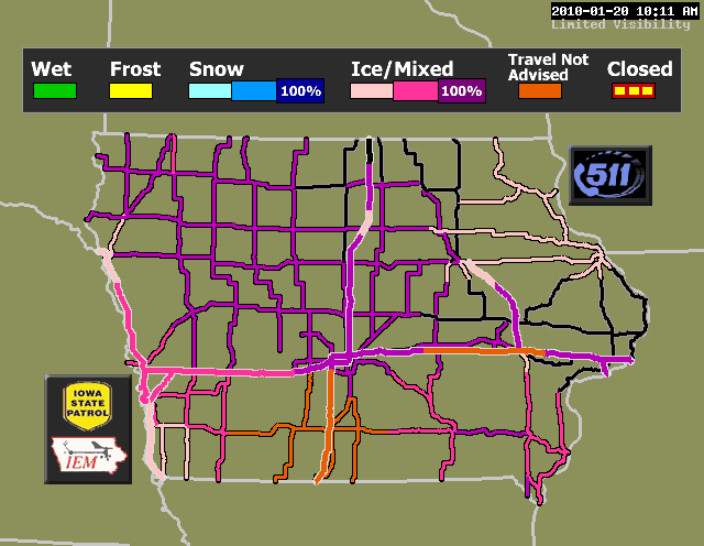 |
| Road conditions in Iowa on January 20, 2010 |
Outside of the hardest hit areas, there were scattered reports of large tree branches being downed by the weight of the ice. Power outages numbered in the 50,000 to 60,000 customer range at the peak during the evening of the 20th. Thirty six hours after the event, over 40,000 customers remained without service. Due to the extensive damage, it was difficult to return service to some of the rural areas. Some of the rural areas were without power for several days to a week after the ice storm. There were still over 700 customers without power 9 days after the ice storm occurred. Most of the outages were in Sac and Carroll Counties.
.jpg) |
| Ice covered tree in Blue Grass, IA (Photo courtesy of Donna Dubberke, NWS Quad Cities Warning Coordination Meteorologist) |
Freezing drizzle followed the main ice event. Though only very light additional accrual of ice took place, trees that were close to breaking continued to fall during the evening and resulted in the continued rise of power outages. On the 22nd, winds began to increase, resulting in additional damage. By mid afternoon on the 22nd, 60,000 customers were without power, and the counties of Sac, Carroll, Audubon, Calhoun, Cass, and Crawford had received a state disaster declaration. The ice storm broke approximately 2250 utility poles and knocked down nearly 1000 miles of power lines. Total damage to the Iowa Rural Electric Cooperatives alone was estimated at $35,000,000. One injury was reported in Sac County when a canopy at a gas station collapsed under the weight of the ice and fell on a woman. She was taken to the hospital for treatment. Her injuries were not life threatening.
.JPG) |
| Ice covered branches in Blue Grass, Iowa (Photo courtesy of Donna Dubberke, NWS Quad Cities Warning Coordination Meteorologist) |


.jpg)
.JPG)