Quad Cities, IA/IL
Weather Forecast Office
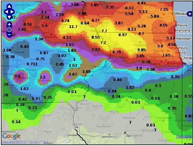
Heavy rains of 8 to 12 inches that occurred on July 22-24 along and north of the Highway 20 corridor between Waterloo, IA and Dubuque, IA resulted in record flooding on the Maquoketa River and Lake Delhi (also called Hartwick Lake). The pressure from the record river flood levels were too much for an earthen berm on the south side of the Lake Delhi/Hartwick Lake Dam. It gave way shortly after 1 pm July 24.
48 Hour Rainfall Totals Ending ~7AM July 24
Hydrograph of the Maquoketa River Level at Manchester Highway 20

Hazardous Weather
Watches, Warnings, & Advisories
Briefing
Hazards Page
View Local Storm Reports
Submit Report
Road Reports
Text Products
Forecasts
Fire Weather
Briefing
Hourly Forecast Graphs
Forecast Discussion
User-Defined Area
Activity Planner
Local Forecasts
Space Weather
Text Products
River Graphs
Airport Forecasts
Snow and Ice Probabilities
Winter Storm Severity Index (WSSI)
Current Conditions
Observations
Drought Monitor
Radar
Satellite
Text Products
Rivers and Lakes
River Graphs
Sunrise/Sunset Tables
Seasons (Equinoxes/Solstices)
Road Reports
Past Weather
Recent Observation History
Climate Summaries
Past Events
Climate Normals/Averages
Climate Records
Climate/Almanac Data
Holiday Climatology
Climate Maps
Monthly Climate Stats
Annual Climate Stats
Observation Site History
Sunrise/Sunset Tables
US Dept of Commerce
National Oceanic and Atmospheric Administration
National Weather Service
Quad Cities, IA/IL
9040 N Harrison Street
Davenport Municipal Airport
Davenport, IA 52806-7326
563-386-3976
Comments? Questions? Please Contact Us.

