National Weather Service United States Department of Commerce

Historic Heavy Rain and Flash Flooding in Dubuque and Jo Daviess Counties
07/27-07/28/2011

Overview:

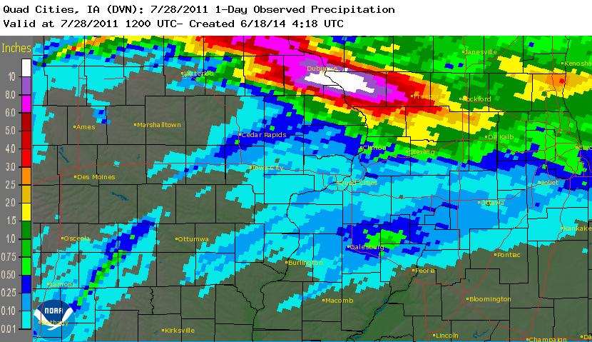
A storm complex known as a "mesoscale convective system (MCS)" stalled along a frontal boundary over northeast Iowa. Thunderstorms developed repeatedly on the back of the storm and then "trained" across the same areas generally along the Highway 20 corridor.  The heaviest rain fell from near Dyersville, IA to Dubuque, IA to Stockton, IL.  With abundant moisture feeding into the storm system and the repetitive development, rainfall totals reached record levels in Dubuque and extreme flash flooding resulted.  Numerous roads were washed out and many others closed.

The Meteorology:

A stationary, back building MCS stalled along a cold front that bisected Iowa from southwest to northeast.  The MCS was fed by 30 to 40 kt low level jet and precipitable water values well over 2 inches.


Rainfall records:

With the tremendous rainfall amounts, the official weather observation site at the Dubuque airport broke several rainfall records:

  • Most rainfall ever on July 27th in Dubuque: 7.47 inches fell on 7/27/11 (previous record was 3.10 inches in 1896)
  • Most rainfall ever on July 28th in Dubuque: 3.27 inches fell on 7/28/11 (previous record was 2.30 inches in 1990)
  • Most rainfall ever on a single day in July in Dubuque: 7.47 inches fell on 7/27/11 (previous record was 6.28 inches on July 1, 1961)
  • Most rainfall ever in a 24-hour period in Dubuque: 10.62 inches fell from the evening of 7/27/11 through the morning of 7/28/11 (previous record was 8.96 inches on 8/21-22/2002)
  • Most rainfall ever for the month of July in Dubuque: The monthly total as of 7/27/11 (and through the end of the month) was 16.01 inches (previous record for July was 12.68 inches in 2010)
  • Most rainfall ever for a single month in Dubuqe: The monthly total as of 7/27/11 (and through the end of the month) was 16.01 inches (previous record for any single month was  15.46 inches in September 1965)
     

Radar Estimated Rainfall:


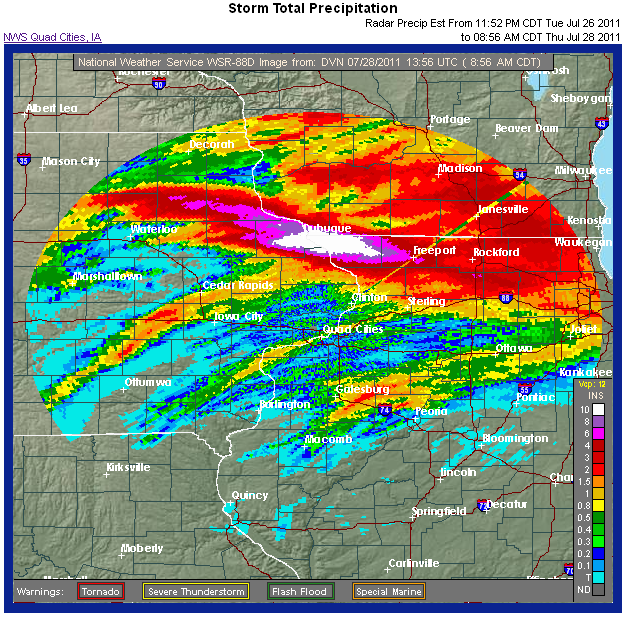
Radar Estimate of Storm Total Rainfall
(45 hour total  from noon on July 26th 
through 9 am on July 28th)

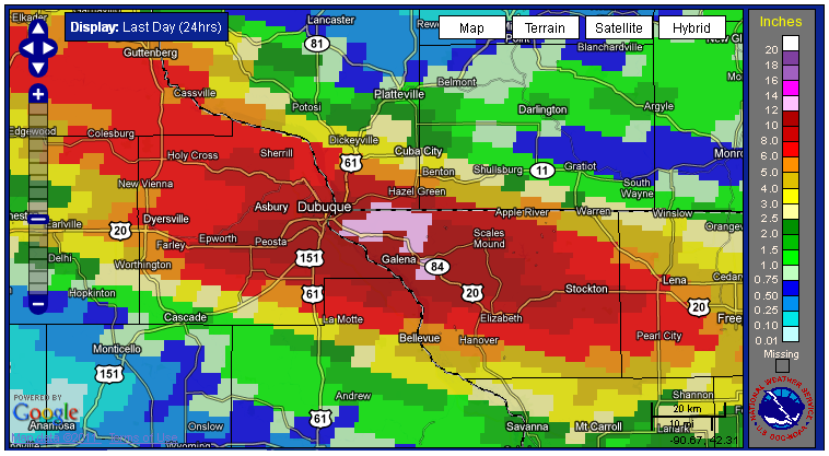
Radar Estimate of 24-hour Rainfall


click for full size image


click for full size image


Official Rainfall Reports from Cooperative Observers (24 hour totals ending at 7 am on 7/28)

NORTHEAST IOWA...
DUBUQUE AIRPORT                 10.31 in.
DUBUQUE LOCK&DAM 11              8.80 in.
NORTHWEST ILLINOIS...
APPLE RIVER CANYON STATE PARK    7.50 in.
ELIZABETH 5S                     9.52 in.
FREEPORT                         5.35 in.
GALENA                          13.45 in.
MOUNT CARROLL                    2.89 in.
STOCKTON 3NNE                    7.14 in.


Supplemental Rainfall Reports from CoCoRAHS Observers

ILLINOIS                  
GALENA 5.7 E                    10.00 in.
FREEPORT 2.0 NW                  5.40 in.
ORANGEVILLE 2.8 NW               2.11 in.
IOWA
BELLEVUE 0.3 SSW                 4.95 in.

-------------------------------------------------------------------------------------

Mainstem Mississippi River Response:

Below is a hydrograph in Dubuque showing the Mississippi River rising about 4 feet in about 12 hours.