| |
| Overview | Maps | Storm Reports/Damage Survey | Discussions |
| General Overview |
| |
| |
What: |
Three rounds of strong thunderstorms tracked east across eastern Iowa, northwest Illinois, and northeast Missouri, as a cold front pushed east across Iowa.
1) Widespread wind damage - east central Iowa into extreme northwest Illinois
2) Golf ball to baseball sized hail - south half of Linn County (Cedar Rapids area) into northern Cedar County
3) Wind damage, flooding rains, & a few tornadoes - NE MO, Sterling/Rock Falls, Edgington, IL - More - |
| |
When: |
June 22, 2015 - 8am-10am, 1230pm-3pm, 630pm-830pm |
| |
Tornado(s): |
3 tornadoes: 1 in Edgington, IL area , 2 in Sterling/Rock Falls, IL area, and straight line winds in Memphis, MO area. |
| |
Rainfall Amounts: |
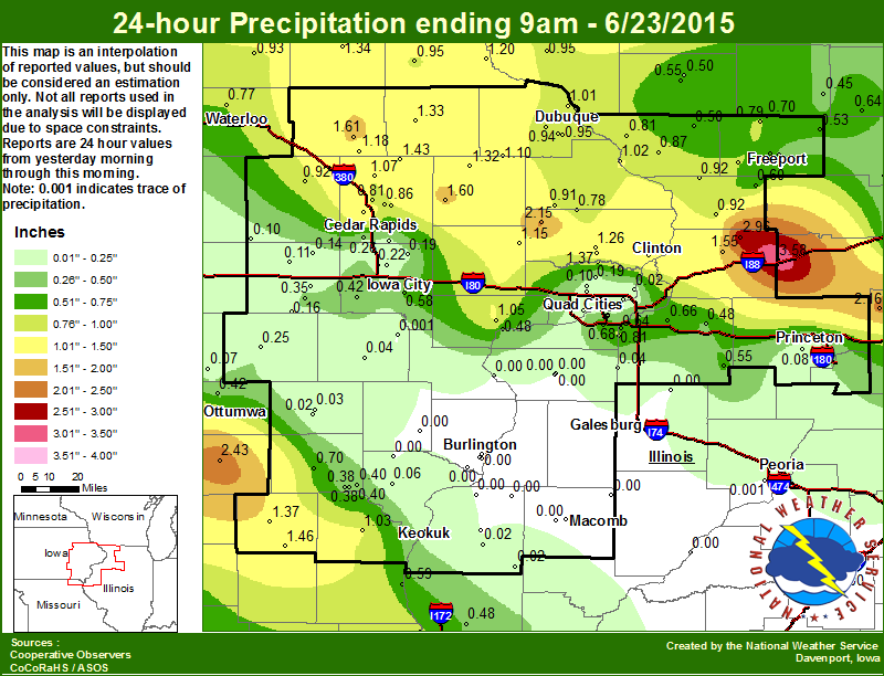
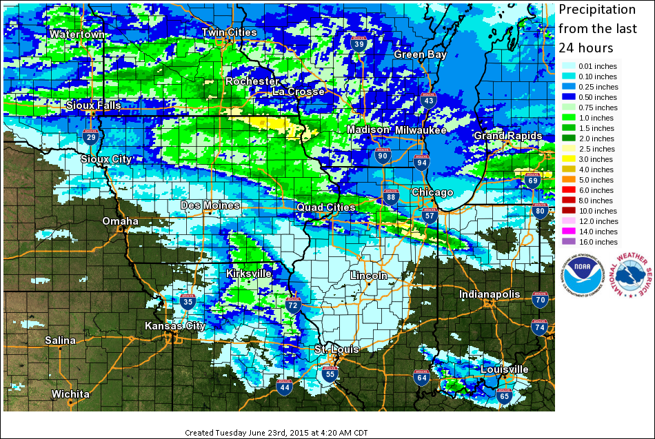
Widespread 1-2 inches north of I80 (with isolated higher totals over 3 inches in eastern Whiteside County) and in southeast Iowa and northeast Missouri (see maps) |
| |
Hail Sizes: |
Pea sized (0.25") to Baseball sized (2.75") |
| |
Wind Speeds: |
60-95 mph |
| |
Flooding Issues: |
Eastern Whiteside County |
| |
Lightning: |
no damage reported |
| |
Hardest Hit Areas: |
Highway 20 Corridor (Wind Damage) - Palo-Cedar Rapids Area-Mechanicsville (Large Hail) - Sterling/Rock Falls(Tornado Damage) - Edgington, IL (Tornado Damage) - NE Missouri (Wind Damage) |
|
| |
| |
| |
| Overview | Maps | Storm Reports/Damage Survey | Discussions |
| Maps |
| |
Local Rainfall
(Created by 11am. Click to enlarge.) |
Regional Rainfall
(Click to enlarge.) |
 |
 |
|
| |
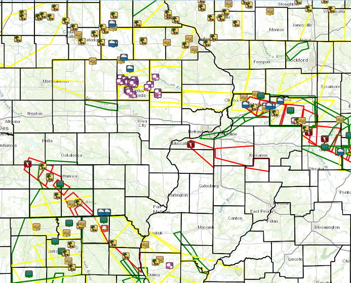
Local Storm Reports
(Click for interactive display.) |
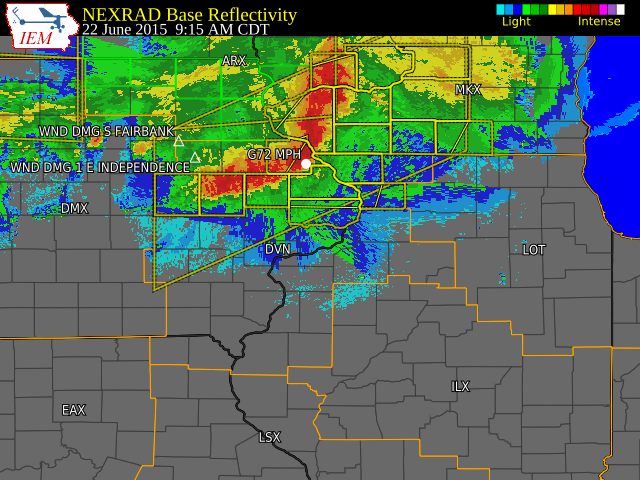
Radar
(Click to enlarge and loop.) |
 |
 |
|
| |
|
| |
| Overview | Maps | Storm Reports/Damage Survey | Discussions |
| Preliminary Local Storm Reports - Courtesy of the Iowa Environmental Mesonet (IEM) |
| |
|
|
| |
| Tornado/Severe Thunderstorm Damage Survey (PNSDVN) |
| |
| |
WHITESIDE COUNTY TORNADO #1...

RATING:                 EF-1
ESTIMATED PEAK WIND:    100 MPH
PATH LENGTH /STATUTE/:  2.19 MILES
PATH WIDTH /MAXIMUM/:   75 YARDS
FATALITIES:             0
INJURIES:               0

START DATE:             JUN 22 2015
START TIME:             714 PM CDT
START LOCATION:         1 MILE NORTHEAST OF ROCK FALLS IL
START LAT/LON:          41.7909 / -89.6707

END DATE:               JUNE 22 2015
END TIME:               718 PM CDT
END LOCATION:           2.5 MILES SOUTHEAST OF ROCK FALLS IL
END LAT/LON:            41.7686 / -89.6402

SURVEY SUMMARY: MAINLY DAMAGE TO TREES AND POWERLINES.


WHITESIDE COUNTY TORNADO #2...

RATING:                 EF-1
ESTIMATED PEAK WIND:    105
PATH LENGTH /STATUTE/:  2.56 MILES
PATH WIDTH /MAXIMUM/:   50 YARDS
FATALITIES:             0
INJURIES:               0

START DATE:             JUN 22 2015
START TIME:             716 PM CDT
START LOCATION:         3.5 MILES SOUTHEAST OF ROCK FALLS IL
START LAT/LON:          41.736 / -89.6509

END DATE:               JUN 22 2015
END TIME:               720 PM CDT
END LOCATION:           3.5 MILES WEST OF HARMON IL
END LAT/LON:            41.7099 / -89.6174

SURVEY SUMMARY: MAINLY DAMAGE TO TREES AND POWERLINES. DAMAGE TO SIDING
ON HOUSE.


EDGINGTON IL TORNADO...

RATING:                 EF-2
ESTIMATED PEAK WIND:    120 MPH
PATH LENGTH /STATUTE/:  4.2 MILES
PATH WIDTH /MAXIMUM/:   400 YARDS
FATALITIES:             0
INJURIES:               0

START DATE:             JUN 22 2015
START TIME:             715 PM CDT
START LOCATION:         1.3 W EDGINGTON / ROCK ISLAND / IL
START LAT/LON:          41.3836 / -90.7944

END DATE:               JUN 22 2015
END TIME:               723 PM CDT
END LOCATION:           2.2 E EDGINGTON / ROCK ISLAND / IL
END LAT/LON:            41.3722 / -90.7164

SURVEY SUMMARY: SEVERAL HOMES HEAVILY DAMAGED WITH ROOFS TORN OFF.
SEVERAL DETACHED GARAGES DESTROYED. LARGE TREE TRUNKS SNAPPED AND
TREES UPROOTED.


NWS DAMAGE SURVEY TEAMS SURVEYED DAMAGE IN SCOTLAND AND CLARK COUNTIES
IN MISSOURI AS WELL, WHERE STRAIGHT LINE WINDS CAUSED A LARGE AMOUNT OF
TREE DAMAGE.
|
| |
EF SCALE: THE ENHANCED FUJITA SCALE CLASSIFIES TORNADOES INTO
THE FOLLOWING CATEGORIES BASED ON THE DAMAGE THEY CAUSE.

EF0...WEAK......65 TO 85 MPH
EF1...WEAK......86 TO 110 MPH
EF2...STRONG....111 TO 135 MPH
EF3...STRONG....136 TO 165 MPH
EF4...VIOLENT...166 TO 200 MPH
EF5...VIOLENT...>200 MPH

NOTE: THE INFORMATION IN THIS STATEMENT IS PRELIMINARY AND
SUBJECT TO CHANGE PENDING FINAL REVIEW OF THE EVENT AND
PUBLICATION IN NWS STORM DATA.
|
|
| |
| |
| Rainfall Reports (RTPDVN - LCODVN) - Courtesy of the Iowa Environmental Mesonet (IEM) |
| |
|
|
|
|
| |
| |
| |
| Overview | Maps | Storm Reports/Damage Survey | Discussions |
| Pre-Event Discussions - Courtesy of the Iowa Environmental Mesonet (IEM) |
| |
Below are links to the most recent Hazardous Weather Outlook, Area Forecast Discussion, SPC Day 1 Outlook, and
SPC Mesoscale Discussion before the event began. |
|
| |
|
|
|
|
|
|
|
|
| |
| |
| |
| Overview | Maps | Storm Reports/Damage Survey | Discussions |
| |
|
|
| |
| |
| |
| |
| |
| |
| |


