Scattered thunderstorms with severe gusts, hail and a tornado risk are possible near a cold front from the Ohio Valley to the Mid-Atlantic tonight. Tropical Storm Bertha is expected to bring tropical storm conditions to portions of the Gulf Coast from the panhandle of Florida into Louisiana through Wednesday. Read More >
|
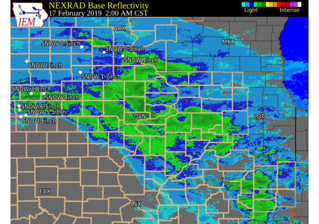
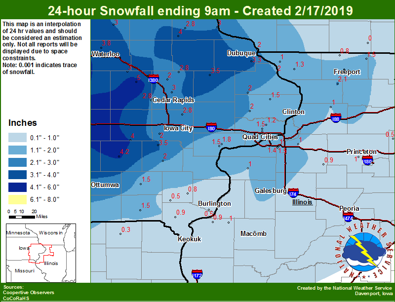
A slow moving winter storm system spread light to moderate snow across the region from late Saturday evening (2/16) into the evening hours of Sunday (2/17). Snowfall totals of 2 to 6 inches fell across much of the forecast area, with the higher amounts occurring further west in west central and central Iowa where 6-9 inches of snow fell. Snowfall totals between a half inch and 2 inches were reported over portions of northeast Missouri, southeast Iowa, and west central Illinois. Snow-covered and slick roads were common, with minor blowing and drifting snow is some open or rural areas.
Official NWS Obs: Moline: 5.2" Davenport: 5.1" Dubuque: 6.5" |
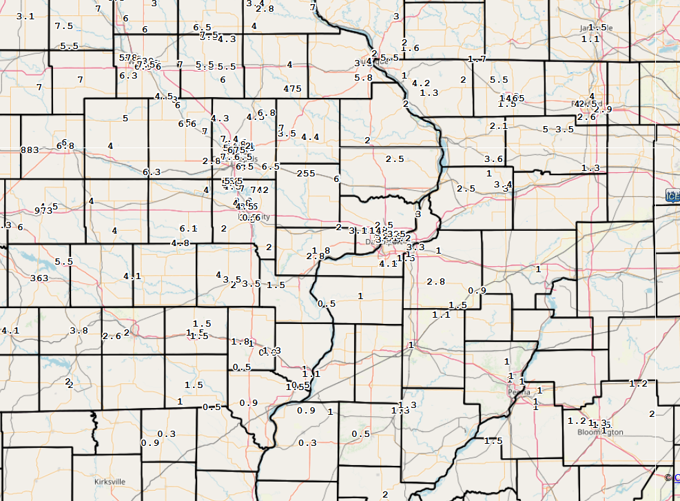
 Regional 48-hr Snowfall |
Snow
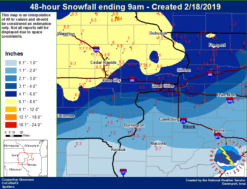
| Local 48-hr Snowfall Map | |
 |
|
| Local Snowfall Map Feb. 17 |
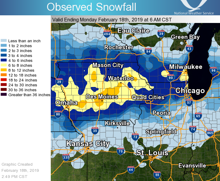
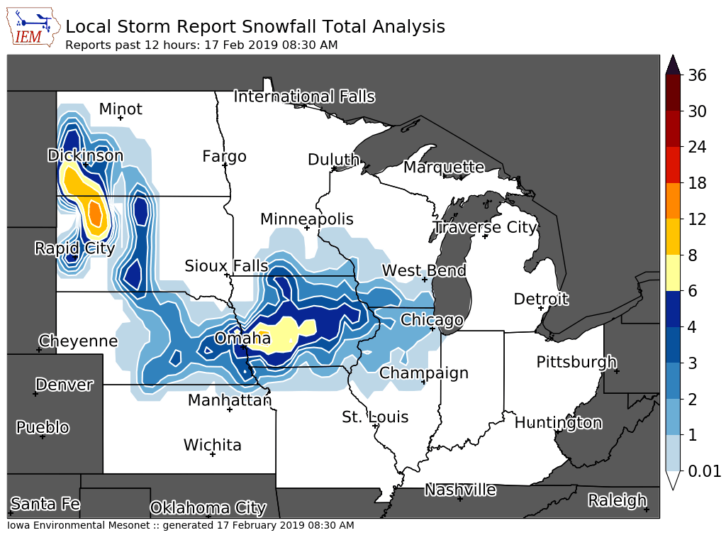
Regional Snowfall Map Feb. 17 |
 |
 |
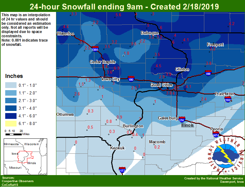
| Local Snowfall Map ​Feb. 18 |
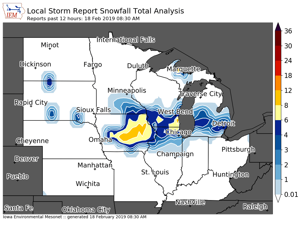
Regional Snowfall Map ​Feb. 18 |
 |
 |
Sunday February 17, 2019. ....IOWA.... NWS Johnston* 5 NNW 6.5 Ames US 30 2 SSE 6.0 Marshalltown 1 NW 6.0 Perry 0 W 5.2 Boone 1 SSW 5.0 Vinton 5.0 Newton 1 NE 4.5 Sigourney 4.2 North English 4.0 Pella 4 N 4.0 Toledo 3 N 4.0 Strawberry Point 4.0 Waterloo ASOS 5 NW 3.8 Wellman 4.0 E 3.5 Monticello 1 E 3.5 Dubuque Arpt 7 SW 3.3 Hampton 1 N 3.1 Beaconsfield 1 NNE 3.0 Mount Auburn 2.2 NNW 3.0 Marion 1.7 NNW 3.0 Tripoli 0 N 3.0 Guttenberg Dam 10 3.0 Coggon 2.8 Fairfax 4.0 NW 2.8 Elkader 6SSW 2.8 Solon 0.3 ESE 2.8 Cresco 1 NE 2.7 Fayette 1 NW 2.5 Washington 2.0 Bellevue LD12 2.0 Dubuque LD11 2.0 Central City 6.7 W 2.0 Centerville 0 NE 2.0 Kalona 7.3 NNW 2.0 Maquoketa 4 W 2.0 Calamus 2.0 NE 2.0 Muscatine 2N 1.8 Davenport 3.8 NNW 1.8 Eldridge 0.7 SSW 1.5 Muscatine 2.1 N 1.5 Davenport 0.9 WNW 1.5 Charlotte 1.9 WNW 1.5 Keosauqua 1.5 Fairfield 1.5 Davenport Arpt 5 N 1.4 Bettendorf 2.2 SE 1.2 Park View 0.2 WSW 1.2 Davenport 0.9 SSW 1.2 Allerton 2 S 1.0 Donnellson 0.9 New London 1.5 SW 0.8 Salem 1S 0.5 Burlington 6.5 SSW 0.5 ....ILLINOIS.... Shannon 0.2 S 2.1 Davis 0.5 N 1.5 Freeport 1.5 Coal Valley 1.9 SE 1.5 Freeport 2.9 WSW 1.5 Quad City Arpt 3 S 1.4 Elizabeth 1.3 Freeport 2.0 NW 1.3 Aledo 1.0 Princeton 1.1 SE 1.0 La Harpe 1.0 Paw Paw 1 E 1.0 Steward 1.0 Princeton 1.0 Coleta 1.4 SSW 1.0 Tiskilwa 2.1 N 1.0 Galena 1.0 Macomb 1.0 Coal Valley 2.6 E 1.0 Geneseo 2.0 NW 1.0 Freeport 1.7 NW 1.0 Kewanee 1 E 0.9 Dallas City 3.0 SSE 0.9 Winslow 4.3 ESE 0.8 Mendota 2 SE 0.5 Roscoe 2SE 0.5 Colchester 3.5 NE 0.5 Ottawa 4 SW 0.3 Rockford ASOS 0.2 Mundelein 0.2 Romeoville 0.0 St Anne 0.0 ....MISSOURI.... Memphis 0.3 Columbia 0.0 ....WISCONSIN.... Steuben 4SE 3 NE 1.2 Viroqua 0.6 Delavan-1 W-WWTP 1 W 0.5 La Crosse WFO 0.5 Madison-ASOS 0.4 Beloit-College 0.1 Brodhead 1 SW 0.0 ....MINNESOTA.... Preston 1.0 Theilman 1SSW 0.8 |
Monday February 18, 2019. ....IOWA.... Solon 0.3 ESE 6.3 Bellevue LD12 6.0 Dubuque LD11 6.0 Elkader 6SSW 5.6 Fayette 1 NW 5.5 Cedar Rapids 2.7 NE 5.0 Rickardsville 0.2 W 5.0 Calamus 2.0 NE 4.5 Waterloo ASOS 5 NW 4.4 NWS Johnston* 5 NNW 4.1 Toledo 3 N 4.0 Guttenberg Dam 10 4.0 Park View 0.2 WSW 3.9 Bettendorf 2.2 SE 3.8 Davenport 0.9 SSW 3.8 Davenport Arpt 5 N 3.7 Fairfax 4.0 NW 3.7 North Liberty 0.7 SSW 3.6 Mount Auburn 2.2 NNW 3.5 Central City 6.7 W 3.5 Maquoketa 4 W 3.5 Monticello 1 E 3.5 Davenport 3.8 NNW 3.5 Ely 0.5 SE 3.4 Tripoli 0 N 3.3 Dubuque Arpt 7 SW 3.2 Coggon 3.2 Dubuque #3 7 SW 3.2 Cresco 1 NE 3.1 Muscatine 2N 3.0 Iowa City 3.0 Eldridge 0.7 SSW 2.9 Davenport 0.9 WNW 2.7 Sigourney 2.6 Muscatine 2.1 N 2.5 Vinton 2.5 Cascade 2.2 Stanley 2.2 Marshalltown 1 NW 2.0 Hampton 1 N 2.0 Anamosa 3 SSW 1.8 North English 1.5 Mason City 1 NNE 1.5 Wellman 4.0 E 1.5 Boone 1 SSW 1.4 Parnell 0.1 SSW 1.3 Washington 1.0 New London 1.5 SW 0.9 Salem 1S 0.8 Burlington 6.5 SSW 0.5 Pella 4 N 0.5 Keosauqua 0.5 Donnellson 0.3 Fairfield 0.3 Beaconsfield 1 NNE 0.0 ....ILLINOIS.... Freeport 2.9 WSW 5.0 Roscoe 2SE 4.6 Mundelein 4.5 Freeport 4.3 Elizabeth 4.1 Geneseo 2.0 NW 4.1 Galena 4.0 Coal Valley 1.9 SE 4.0 Freeport 1.7 NW 4.0 Quad City Arpt 3 S 3.8 Coleta 1.4 SSW 3.8 Rockford ASOS 3.6 Freeport 2.0 NW 3.5 Moline 0.7 NNE 3.4 Shannon 0.2 S 3.2 Rochelle 3.2 Coal Valley 2.6 E 2.5 Kewanee 1 E 2.4 Gladstone LD18 2.0 Mendota 2 SE 2.0 Paw Paw 1 E 1.8 Princeton 1.1 SE 1.7 Princeton 1.7 Romeoville 1.6 Steward 1.2 Aledo 1.0 Ottawa 4 SW 1.0 La Harpe 1.0 Dallas City 3.0 SSE 0.4 Colchester 3.5 NE 0.2 Bentley 0.0 Augusta 0.0 ....MISSOURI.... Memphis 0.0 Columbia 0.0 ....WISCONSIN.... Beloit-College 6.0 Madison-ASOS 5.3 Delavan-1 W-WWTP 1 W 4.2 Brodhead 1 SW 4.2 La Crosse WFO 4.1 Viroqua 3.8 Steuben 4SE 3 NE 3.0 Lancaster 4WSW 3.0 ....MINNESOTA.... Preston 2.5 Theilman 1SSW 0.0 |
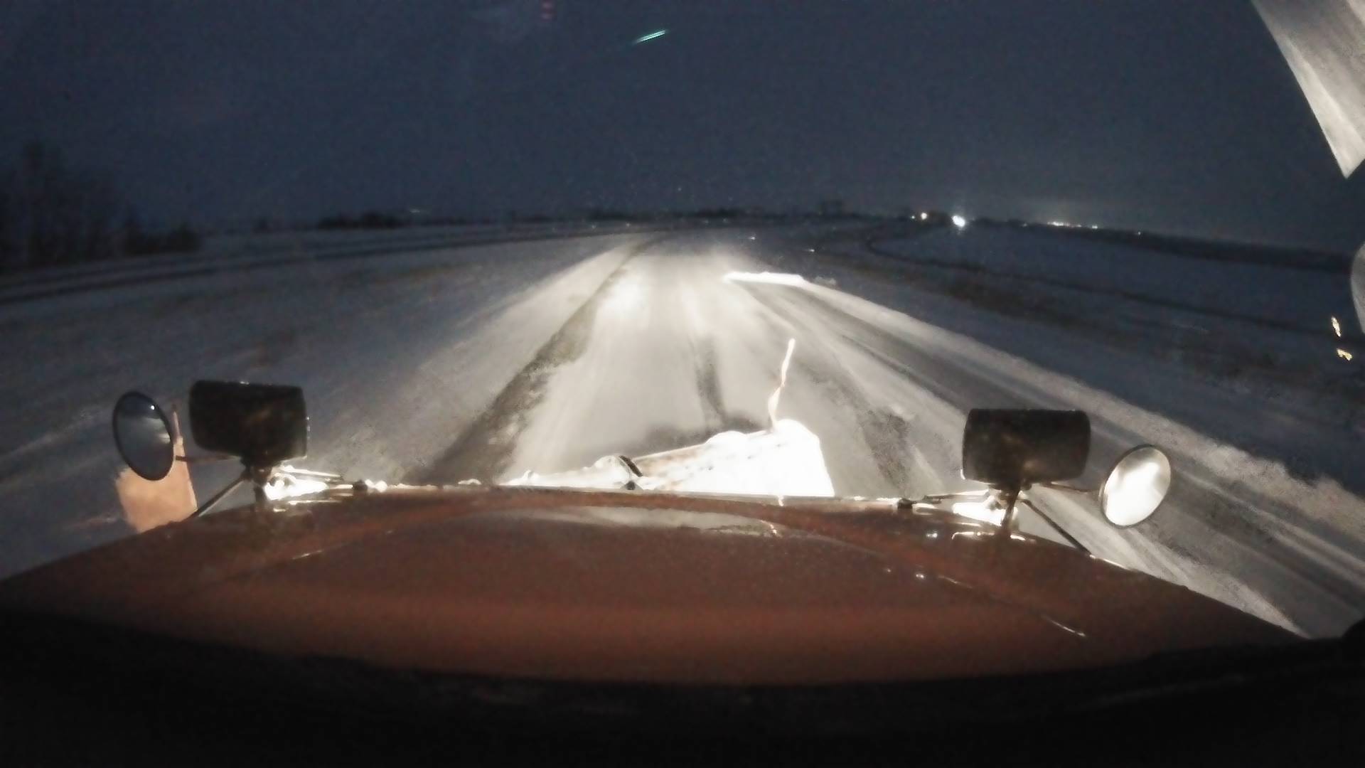
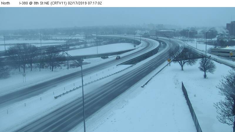
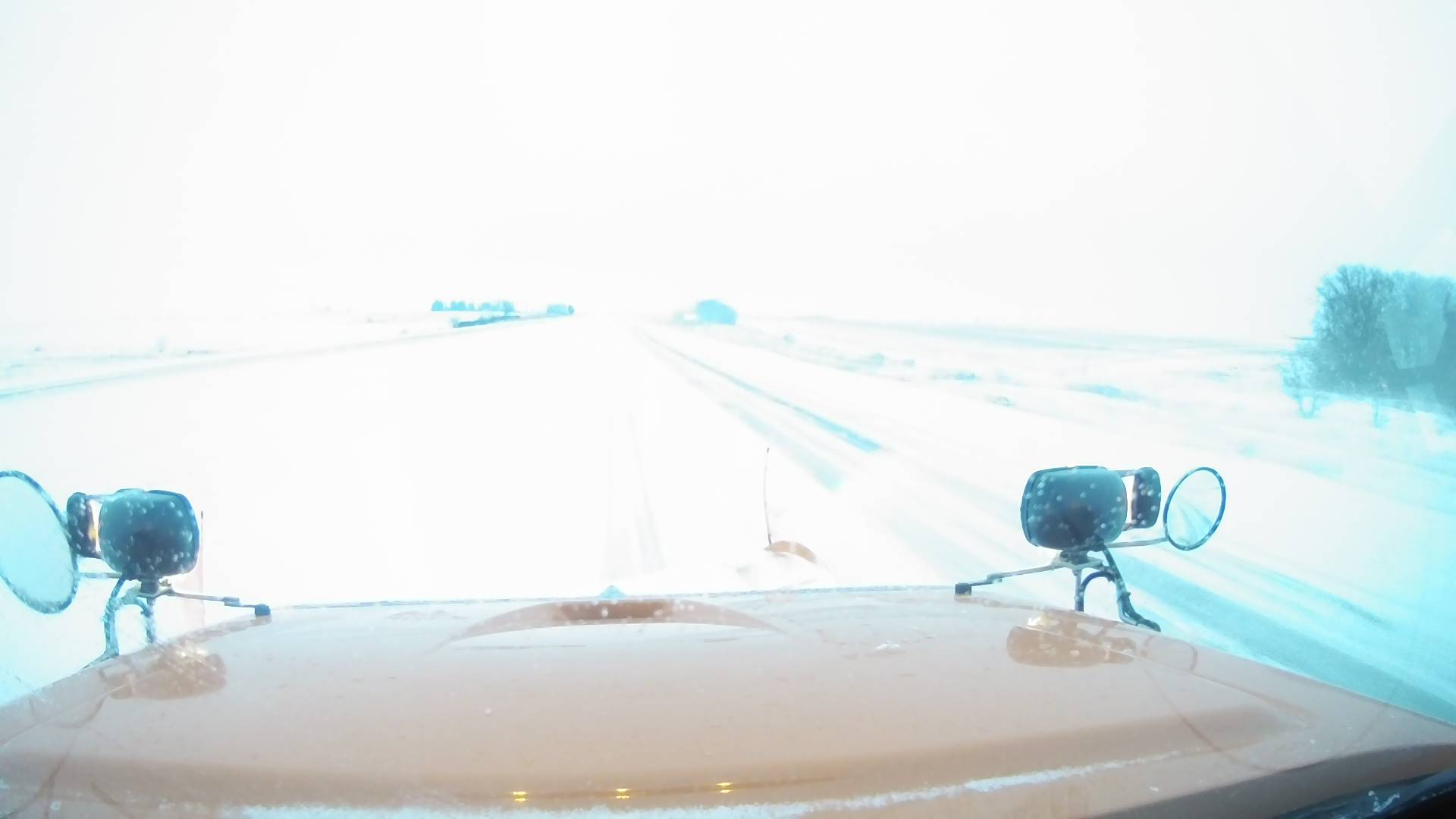
Photos
 |
 |
 |
 |
| I-80 near Durant, IA (IA DOT) |
I-380 Cedar Rapids, IA (IA DOT) |
I-380 near Brandon, IA (IA DOT) |
IA-92 near Sigourney, IA (IA DOT) |
Storm Reports Map - Courtesy IEM
|
MAP BELOW AS OF 745 PM 2/17/2019 |
PUBLIC INFORMATION STATEMENT NATIONAL WEATHER SERVICE QUAD CITIES IA IL 543 PM CST MON FEB 18 2019 ...48-HOUR SNOWFALL REPORTS... OBSERVATIONS ARE COLLECTED FROM A VARIETY OF SOURCES WITH VARYING EQUIPMENT AND EXPOSURES. WE THANK ALL VOLUNTEER WEATHER OBSERVERS FOR THEIR DEDICATION. NOT ALL DATA LISTED ARE CONSIDERED OFFICIAL. LOCATION AMOUNT TIME/DATE LAT/LON 2 NE CEDAR RAPIDS 8.5 IN 0600 AM 02/18 42.00N/91.63W NORTH LIBERTY 8.1 IN 0800 AM 02/18 41.73N/91.62W DUBUQUE L/D 11 8.0 IN 0600 AM 02/18 42.54N/90.65W STANLEY 7.7 IN 0700 AM 02/18 42.64N/91.81W VINTON 7.5 IN 0700 AM 02/18 42.17N/92.00W CEDAR RAPIDS NO. 1 7.2 IN 0500 PM 02/18 42.03N/91.58W FULTON 7.0 IN 0905 AM 02/18 42.15N/90.68W MONTICELLO 7.0 IN 0718 AM 02/18 42.25N/91.17W SIGOURNEY 6.8 IN 0800 AM 02/18 41.33N/92.20W DUBUQUE AIRPORT 6.5 IN 0600 AM 02/18 42.53N/90.71W 2 NNW MOUNT AUBURN 6.5 IN 0600 AM 02/18 42.29N/92.11W 2 SSE ATKINS 6.5 IN 0700 AM 02/18 41.96N/91.84W 2 ENE CALAMUS 6.5 IN 0700 AM 02/18 41.84N/90.73W 2 ENE BOLTON 6.5 IN 0730 AM 02/18 42.27N/89.68W COGGON 6.0 IN 0500 AM 02/18 42.28N/91.53W DAVENPORT 6.0 IN 0800 AM 02/18 41.55N/90.59W PEC RVR AT FREEPORT 5.8 IN 0700 AM 02/18 42.30N/89.62W 3 NNE LAFAYETTE 5.5 IN 0700 AM 02/18 42.20N/91.65W 1 ESE COAL VALLEY 5.5 IN 0700 AM 02/18 41.43N/90.42W MAQUOKETA 5.5 IN 0700 AM 02/18 42.07N/90.70W NORTH ENGLISH 5.5 IN 0700 AM 02/18 41.52N/92.07W ELIZABETH 5.4 IN 0630 AM 02/18 42.33N/90.25W 2 NNW DAVENPORT 5.3 IN 0730 AM 02/18 41.58N/90.62W SHANNON 5.3 IN 0700 AM 02/18 42.15N/89.74W 3 SSW ANAMOSA 5.2 IN 0600 AM 02/18 42.08N/91.30W QUAD CITY INTL ARPT 5.2 IN 0518 AM 02/18 41.45N/90.51W NWS DAVENPORT 5.1 IN 0600 AM 02/18 41.61N/90.58W PARK VIEW 5.1 IN 0700 AM 02/18 41.69N/90.54W GLADSTONE L/D 18 5.0 IN 0600 AM 02/18 40.88N/91.03W GALENA 5.0 IN 0700 AM 02/18 42.42N/90.43W 2 SSE DAVENPORT 5.0 IN 0530 AM 02/18 41.53N/90.59W RIVERDALE 5.0 IN 0630 AM 02/18 41.54N/90.45W IOWA CITY 5.0 IN 0700 AM 02/18 41.65N/91.53W 1 WNW FREEPORT 5.0 IN 0650 AM 02/18 42.30N/89.66W 1 WNW FREEPORT 4.8 IN 0830 AM 02/18 42.31N/89.66W 1 SW COLETA 4.8 IN 0700 AM 02/18 41.89N/89.81W 2 N MUSCATINE 4.8 IN 0700 AM 02/18 41.47N/91.04W 4 NW WINTHROP GOLF COURSE 4.4 IN 0900 AM 02/18 42.55N/91.71W ELDRIDGE 4.4 IN 0800 AM 02/18 41.64N/90.59W 1 W PORT BYRON 4.2 IN 0900 AM 02/18 41.62N/90.35W 1 SE DAVENPORT 4.2 IN 0700 AM 02/18 41.54N/90.59W 2 N MUSCATINE 4.0 IN 0700 AM 02/18 41.45N/91.07W 2 NNW WARNER 3.5 IN 0700 AM 02/18 41.45N/90.40W 1 E KEWANEE 3.3 IN 0700 AM 02/18 41.25N/89.90W WASHINGTON 3.0 IN 0700 AM 02/18 41.28N/91.68W 1 SE PRINCETON 2.7 IN 0700 AM 02/18 41.37N/89.45W PRINCETON 2.7 IN 0700 AM 02/18 41.38N/89.48W HENNEPIN 2.2 IN 0500 PM 02/18 41.25N/89.34W ALEDO 2.0 IN 0700 AM 02/18 41.22N/90.75W KEOSAUQUA 2.0 IN 0700 AM 02/18 40.73N/91.97W LA HARPE 2.0 IN 0700 AM 02/18 40.58N/90.97W FAIRFIELD 1.8 IN 0800 AM 02/18 41.03N/91.95W 1 WSW NEW LONDON 1.7 IN 0700 AM 02/18 40.91N/91.43W 2 S PRAIRIE CITY 1.5 IN 0600 AM 02/18 40.59N/90.46W SALEM 1 S 1.3 IN 0700 AM 02/18 40.83N/91.62W DONNELLSON 1.2 IN 0700 AM 02/18 40.63N/91.57W 1 WSW SPRING GROVE 1.0 IN 0700 AM 02/18 40.73N/91.19W 2 ENE ARGYLE LAKE STATE 0.7 IN 0700 AM 02/18 40.46N/90.75W MEMPHIS 0.3 IN 0600 AM 02/18 40.46N/92.17W |
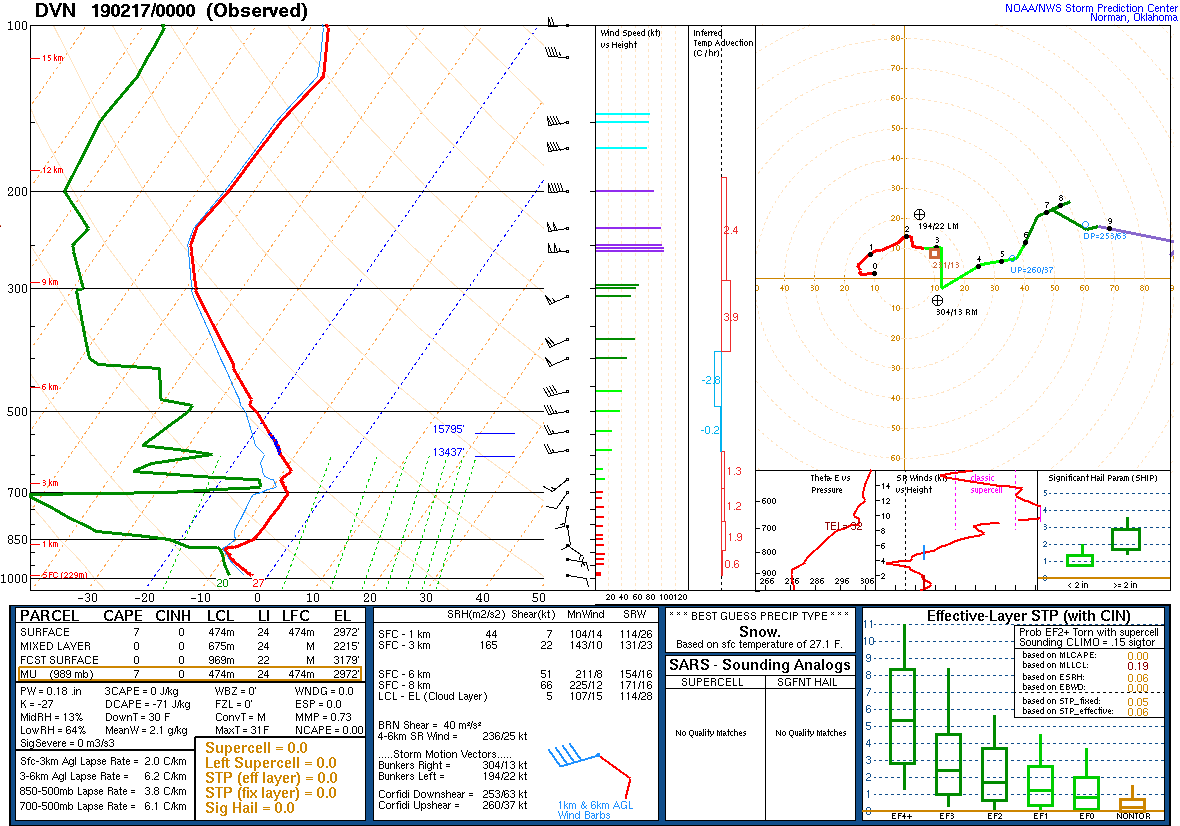
Environment
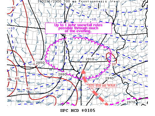
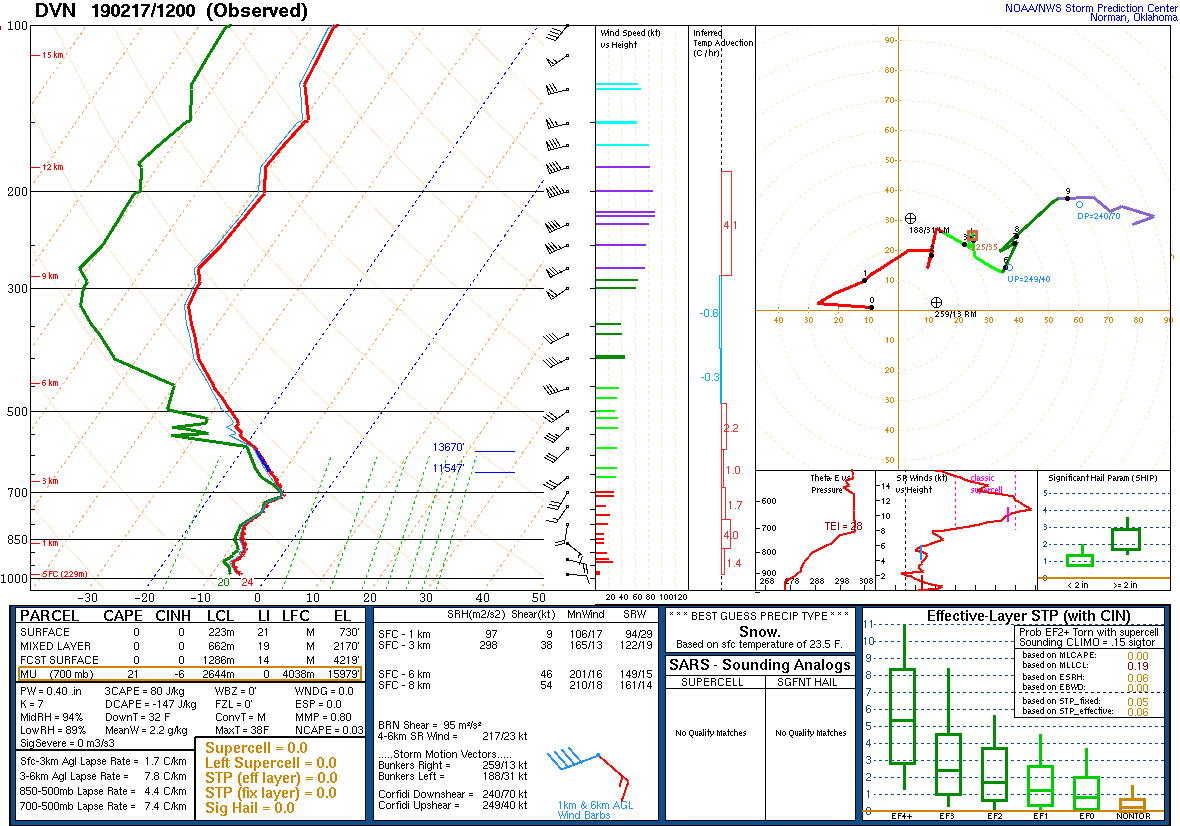
| Figure 1: DVN 00z Sounding 02/17/2019 | Figure 2: Mesoscale Discussion #105 |
 |
 |
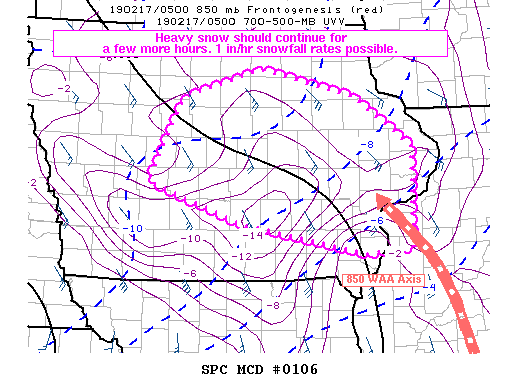
| Figure 3: DVN 12z Sounding 02/17/2019 | Figure 4: Mesoscale Discussion #106 |
 |
 |
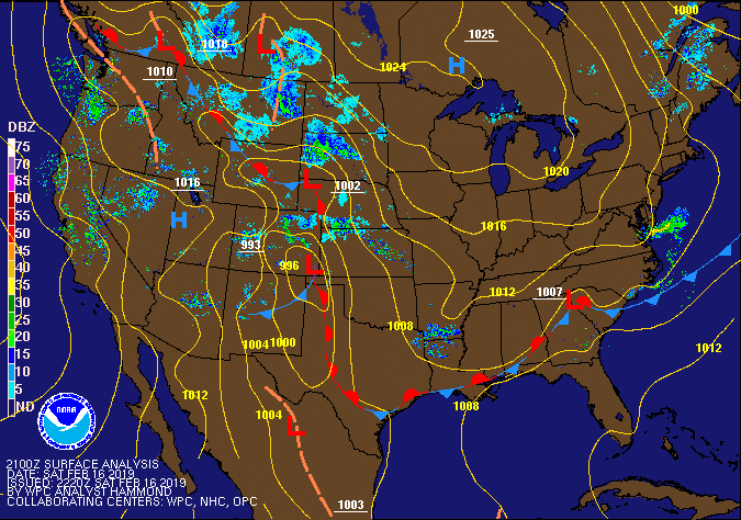
| Figure 5: WPC Radar / Fronts / Pressure Loop | |
 |
 |
Media use of NWS Web News Stories is encouraged! Please acknowledge the NWS as the source of any news information accessed from this site. |
|