Overview
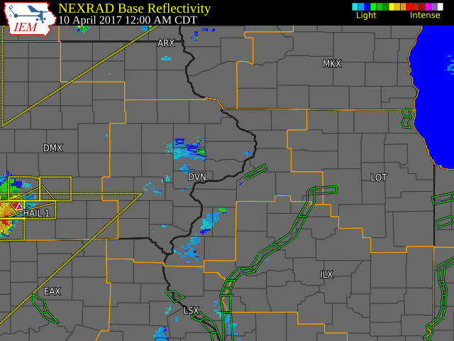
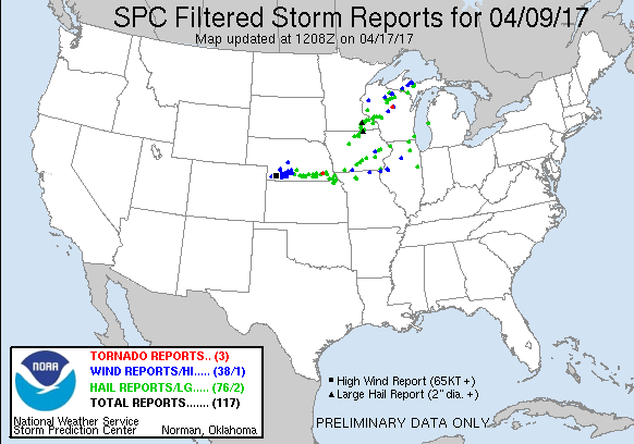
Showers and thunderstorms moved across eastern Iowa, northwest Illinois, and northeast Missouri during the morning of April 10th, as a weak cold front moved across central Iowa. Some of these thunderstorms were severe, producing hail up to the size of ping pong balls over Linn County, and wind gusts over 60 MPH in Lee County Iowa. Temperatures remained very warm overnight, as lows ranged from 50 in Independence to 59 in Sterling.
| Rainfall Map |
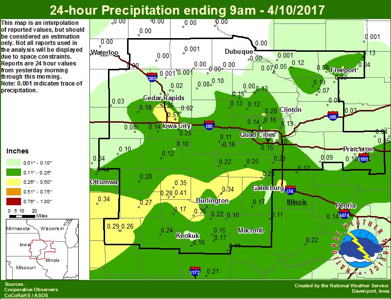 |
24 hour precipitation reports (in Inches),
for eastern Iowa, northwest and west central Illinois,
and northeast Missouri. Reported between Midnight and 9 AM,
Monday April 10, 2017.

....IOWA....
Iowa City 4.5 N                  0.57
Salem 3.1 ESE                    0.41
Fort Madison 0.9 NE              0.36
Cedar Rapids Arpt                0.36
Mt Pleasant                      0.35
Bloomfield                       0.34
Centerville                      0.33
Beaconsfield                     0.29
Pella                            0.29
Salem 1S                         0.28
De Witt 4S                       0.28
Keosauqua                        0.27
Iowa City                        0.25
Mason City ASOS                  0.22
Fairfield                        0.20
Mason City                       0.18
Burlington 6.5 SSW               0.18
Burlington Arpt                  0.18
Burlington 2S                    0.18
Amana 4.7 W                      0.18
Iowa City Arpt                   0.17
Donnellson                       0.17
Park View 0.2 WSW                0.16
Davenport 2.9 W                  0.15
Lost Nation 0.3 S                0.15
Kalona 7.3 NNW                   0.14
Eldridge 0.7 SSW                 0.14
Mason City*                      0.14
Ottumwa ASOS                     0.14
Lowden                           0.13
Delmar 2.3 NW                    0.13
Le Claire 1.8 NNE                0.13
Williamsburg                     0.13
Davenport Arpt                   0.12
Calamus 2.0 NE                   0.12
Washington                       0.12
Bettendorf 2.2 SE                0.11
Muscatine 2N                     0.11
Davenport 0.9 SSW                0.10
Davenport 0.9 WNW                0.10
Oskaloosa                        0.10
Sigourney                        0.10
Center Junction 2.6 W            0.10
Ainsworth 7.4 N                  0.10
Anamosa 3 SSW                    0.08
Parnell 0.1 SSW                  0.08
Eldridge 0.6 ESE                 0.07
Bellevue 0.3 SSW                 0.07
Camanche 1.2 W                   0.06
Keokuk 0.6 NE                    0.06
Grinnell                         0.06
Bellevue LD12                    0.05
Gilman                           0.05
Oskaloosa AWOS                   0.04
Le Claire LD14                   0.04
Keokuk LD19                      0.04
Cedar Rapids 2.2 WSW             0.04
Marion 1.2 NE                    0.03
Cedar Rapids 2.7 NE              0.03
Belle Plaine                     0.03
Center Point 0.6 NNW             0.02
Marion 1.7 NNW                   0.02
Solon 0.3 ESE                    0.02
Cedar Rapids 3.4 NW              0.02
Ames US 30                       0.01
Marshalltown ASOS                0.00
Manchester                       0.00
Central City 6.7 W               0.00
NWS Johnston*                    0.00
Coggon                           0.00
Maquoketa 4W                     0.00
Tripoli                          0.00
Quasqueton 0.4 WSW               0.00
Monticello                       0.00
Waterloo ASOS                    0.00
Cresco                           0.00
Pella AWOS                       0.00
Guttenberg Dam 10                0.00
Elkader 6SSW                     0.00
Dubuque LD11                     0.00
Mount Auburn 2.2 NNW             0.00
Perry                            0.00
Fayette                          0.00
Cascade                          0.00
Marshalltown                     0.00
Hampton                          0.00
Grinnell AWOS                    0.00
Dubuque Arpt                     0.00
Hopkinton 5.4 WSW                0.00
Toledo                           0.00
Oelwein AWOS                     0.00
Boone                            0.00
....ILLINOIS....
Gladstone LD18                   0.34
Galesburg                        0.32
Ottawa                           0.30
Alexis                           0.28
Freeport 2.0 NW                  0.28
Colchester 3.5 NE                0.26
Aledo                            0.25
Freeport                         0.25
Macomb                           0.24
Havana                           0.22
New Boston LD17                  0.22
Dallas City 3.0 SSE              0.22
Quincy ASOS                      0.21
New Windsor 2.0 N                0.21
Freeport 1.7 ESE                 0.19
Mount Carroll                    0.19
Bentley                          0.17
Roseville 0.6 WNW                0.17
Altona                           0.17
Ill. City LD16                   0.16
Warsaw 5.8 SE                    0.16
Moline 0.7 NNE                   0.15
Quad City Arpt                   0.15
Carthage 0.8 E                   0.15
Peoria ASOS                      0.14
Davis 0.5 N                      0.13
Elizabeth                        0.12
Augusta                          0.11
Prairie City 2S                  0.11
Tiskilwa 2.1 N                   0.10
Moline 0.9 N                     0.10
La Harpe                         0.10
Coal Valley 1.9 SE               0.10
Kewanee                          0.09
Princeton 1.1 SE                 0.08
Princeton                        0.08
Jacksonville AWOS                0.08
Joliet                           0.08
Pearl City 0.4 SW                0.08
Chadwick 2.7 WSW                 0.07
Romeoville                       0.07
Princeton 1.5 S                  0.07
Mendota                          0.05
Ridott 0.1 NE                    0.04
Steward                          0.04
La Moille 0.2 NNE                0.04
Coleta 1.4 SSW                   0.03
Rock Falls                       0.03
Rochelle AWOS                    0.03
Shannon 0.2 S                    0.03
Mundelein                        0.02
Lincoln NWS                      0.02
Bloomington Airport              0.01
Galena                           0.00
Rockford ASOS                    0.00
Ogden                            0.00
Fulton 0.8 SSW                   0.00
Windsor                          0.00
Decatur Airport                  0.00
St Anne                          0.00
Tuscola                          0.00
Roscoe 2SE                       0.00
Galesburg Arpt                   0.00
....MISSOURI....
Memphis                          0.29
Kirksville ASOS                  0.28
Memphis 0.1 S                    0.26
Kahoka 0.6 S                     0.24
Chillicothe                      0.00
Columbia                         0.00
....WISCONSIN....
La Crosse WFO                    0.01
Madison-ASOS                     0.00
Brodhead                         0.00
Beloit-College                   0.00
Watertown-AWOS                   0.00
Sullivan-NWS                     0.00
Prairie du Chien AWOS            0.00
Allenton-WWTP                    0.00
Viroqua                          0.00
Whitewater                       0.00
....MINNESOTA....
Byron 4N                         0.42
Theilman 1SSW                    0.33
Grand Meadow                     0.10
|
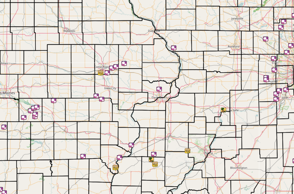
| Interactive LSR Map | SPC Reports |
 |
 |
PRELIMINARY LOCAL STORM REPORT...SUMMARY
NATIONAL WEATHER SERVICE QUAD CITIES IA IL
538 AM CDT MON APR 10 2017

..TIME...   ...EVENT...      ...CITY LOCATION...     ...LAT.LON...
..DATE...   ....MAG....      ..COUNTY LOCATION..ST.. ...SOURCE....
            ..REMARKS..

0110 AM     HAIL             ELDRIDGE                41.64N 90.57W
04/10/2017  M0.50 INCH       SCOTT              IA   NWS EMPLOYEE

0145 AM     HAIL             KALONA                  41.49N 91.70W
04/10/2017  E0.88 INCH       WASHINGTON         IA   PUBLIC

0151 AM     TSTM WND GST     CEDAR RAPIDS MUNICIPAL  41.88N 91.72W
04/10/2017  M59.00 MPH       LINN               IA   ASOS

            FROM ASOS

0157 AM     HAIL             ELY                     41.88N 91.59W
04/10/2017  E1.00 INCH       LINN               IA   TRAINED SPOTTER

            HAIL LASTED 3-4 MINUTES AND ENDED AT 201 AM PER SPOTTER.

0200 AM     HAIL             2 E BERTRAM             41.95N 91.50W
04/10/2017  E1.75 INCH       LINN               IA   BROADCAST MEDIA

            PUBLIC REPORT RELAYED VIA MEDIA.

0205 AM     HAIL             3 N MOUNT VERNON        41.97N 91.42W
04/10/2017  E1.75 INCH       LINN               IA   BROADCAST MEDIA

            PUBLIC REPORT RELAYED BY MEDIA.

0215 AM     HAIL             5 E MARTELLE            42.02N 91.26W
04/10/2017  E1.50 INCH       JONES              IA   BROADCAST MEDIA

            PUBLIC REPORT RELAYED BY MEDIA. TIME ESTIMATED BY RADAR.

0314 AM     HAIL             HANOVER                 42.25N 90.28W
04/10/2017  E1.00 INCH       JO DAVIESS         IL   BROADCAST MEDIA

            PUBLIC REPORT RELAYED BY BROADCAST MEDIA.

0355 AM     TSTM WND GST     KEOKUK AIRPORT          40.47N 91.43W
04/10/2017  E60.00 MPH       LEE                IA   AWOS

            FROM AWOS.

0401 AM     HAIL             FORT MADISON            40.62N 91.35W
04/10/2017  M1.00 INCH       LEE                IA   TRAINED SPOTTER

0413 AM     HAIL             BURLINGTON              40.81N 91.12W
04/10/2017  M0.25 INCH       DES MOINES         IA   TRAINED SPOTTER

0430 AM     TSTM WND GST     MACOMB MUNICIPAL AIRPOR 40.52N 90.65W
04/10/2017  M61.00 MPH       MCDONOUGH          IL   AWOS

            FROM AWOS. TIME ESTIMATED.
|
|
 |
Media use of NWS Web News Stories is encouraged! Please acknowledge the NWS as the source of any news information accessed from this site. |
|