Well above average temperatures will continue across the West this week, potentially breaking some daily high temperature records. A storm system dropping south out of Canada will bring a wintry mix to the Upper Midwest and Great Lakes Tuesday, pushing into the Central Appalachians and interior Northeast on Wednesday. Read More >
Overview
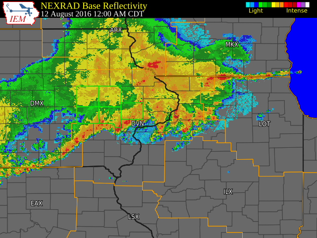
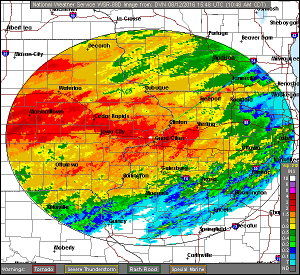
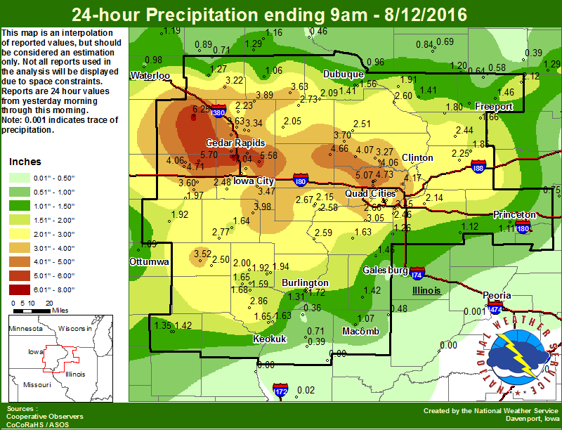
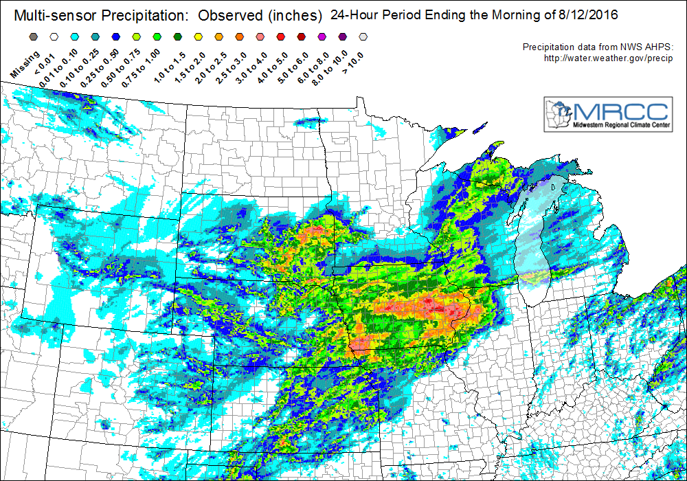
Heavy rain-producing showers and thunderstorms prevailed across much of the area the evening of August 11 and early morning of August 12. Widespread rainfall totals of 2 to 5 inches were common across east central and southeast Iowa and northwest Illinois, with some higher amounts of 5 to 7 inches within 20 miles of a line from Cedar Rapids to Davenport. Flash flooding resulted in Marengo, Iowa where streets were covered with flood waters between 12 and 18 inches deep. In addition, several streams, creeks and tributary rivers saw water levels rise quickly, with some flooding out of their banks. Meanwhile, parts of west central Illinois southeast of a line from Keokuk and Macomb received little if any rain overnight. As of 7 am August 12, low temperatures were between 70 and 73 area-wide.
 |
 |
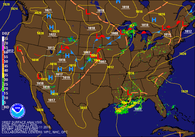
Heavy rains continued further to the east August 12 and 13. |
| Surface and Radar Loop 1pm 8/11 to 10am 8/12 |
Radar Rainfall Estimate |
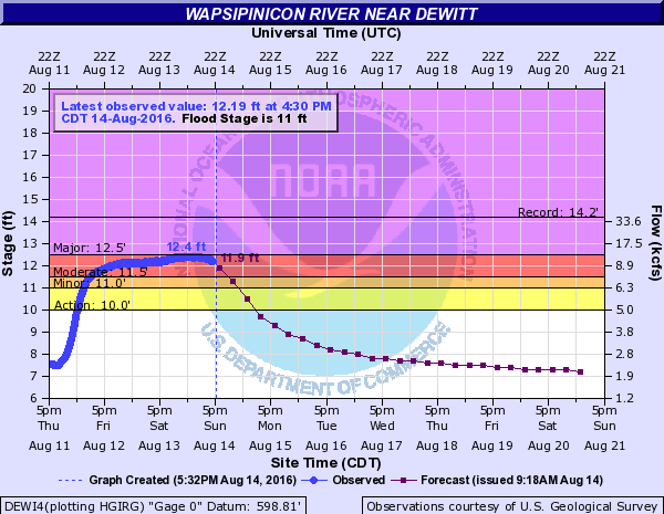
Flooding
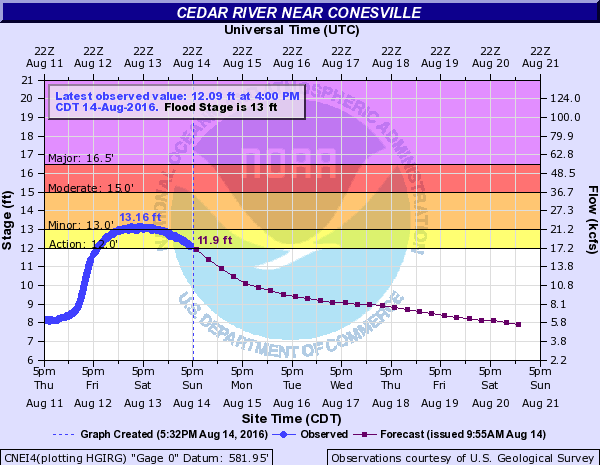
Hydrographs
 |
 |
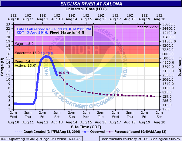 |
| DeWitt | Conesville | Kalona |
Radar/Photos
|
| Radar Estimated Rainfall |
Storm Reports
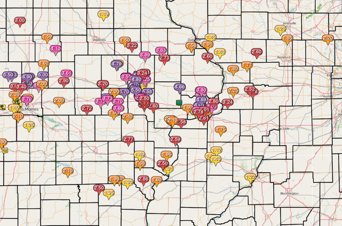
| Interactive Storm Report Map |
 |
PRELIMINARY LOCAL STORM REPORT...SUMMARY
NATIONAL WEATHER SERVICE QUAD CITIES IA IL
1218 PM CDT FRI AUG 12 2016
..TIME... ...EVENT... ...CITY LOCATION... ...LAT.LON...
..DATE... ....MAG.... ..COUNTY LOCATION..ST.. ...SOURCE....
..REMARKS..
0652 PM HEAVY RAIN 1 NE VINTON 42.17N 92.01W
08/11/2016 M1.30 INCH BENTON IA TRAINED SPOTTER
FELL IN 40 MINUTES
0739 PM HEAVY RAIN 3 E CEDAR RAPIDS 41.97N 91.61W
08/11/2016 M1.25 INCH LINN IA TRAINED SPOTTER
0748 PM HEAVY RAIN 2 NNE CEDAR RAPIDS 42.01N 91.65W
08/11/2016 M1.02 INCH LINN IA TRAINED SPOTTER
0749 PM HEAVY RAIN 1 SSE CEDAR RAPIDS 41.95N 91.66W
08/11/2016 M1.00 INCH LINN IA TRAINED SPOTTER
IN 35 MINUTES
0804 PM FLASH FLOOD 1 SSE CEDAR RAPIDS 41.96N 91.66W
08/11/2016 LINN IA BROADCAST MEDIA
LOCAL MEDIA REPORTED A CAR HAD STALLED OUT IN HIGH WATER
OVER THE ROAD. THE OCCUPANTS HAD TO BE HELPED TO SAFETY.
0812 PM HEAVY RAIN 1 E INDEPENDENCE 42.47N 91.88W
08/11/2016 M1.50 INCH BUCHANAN IA TRAINED SPOTTER
0822 PM HEAVY RAIN 1 NNW ELY 41.89N 91.59W
08/11/2016 M1.40 INCH LINN IA TRAINED SPOTTER
MEASURED BY A HOME WEATHER STATION.
0835 PM HEAVY RAIN ATKINS 42.00N 91.86W
08/11/2016 M1.30 INCH BENTON IA PUBLIC
VIA SOCIAL MEDIA
0845 PM HEAVY RAIN 1 SSE CEDAR RAPIDS 41.95N 91.66W
08/11/2016 M2.00 INCH LINN IA TRAINED SPOTTER
MODERATE TO HEAVY RAIN CONTINUES. TYPICAL PONDING OF
WATER IN LOW LYING AREAS. NO SIGNFICANT WATER ISSUES YET.
0857 PM HEAVY RAIN 1 W NORTH LIBERTY 41.74N 91.63W
08/11/2016 M3.27 INCH JOHNSON IA TRAINED SPOTTER
FELL IN THE LAST 90 MINUTES.
0935 PM HEAVY RAIN MIDDLE AMANA 41.80N 91.90W
08/11/2016 M3.50 INCH IOWA IA PUBLIC
MODERATE TO HEAVY RAIN CONTINUES. LOTS OF STANDING WATER.
NO FLASH FLOODING OBSERVED SO FAR.
0958 PM HEAVY RAIN 1 SSE CEDAR RAPIDS 41.95N 91.66W
08/11/2016 M2.75 INCH LINN IA TRAINED SPOTTER
1.00 INCHES IN THE LAST HOUR.
1012 PM HEAVY RAIN LOWDEN 41.86N 90.92W
08/11/2016 M1.82 INCH CEDAR IA CO-OP OBSERVER
TOTAL SINCE 830 PM. 0.70 INCHES FELL IN 15 MINTUES. 2.33
IS THE TOTAL FOR THE DAY.
1025 PM HEAVY RAIN W BELLE PLAINE 41.90N 92.28W
08/11/2016 M2.15 INCH BENTON IA TRAINED SPOTTER
1054 PM HEAVY RAIN MIDDLE AMANA 41.80N 91.90W
08/11/2016 M4.70 INCH IOWA IA FIRE DEPT/RESCUE
1.2 INCHES SINCE THE LAST UPDATE.
1104 PM FLASH FLOOD SWISHER 41.84N 91.70W
08/11/2016 JOHNSON IA EMERGENCY MNGR
THE CRANDIC RAILROAD EXPERIENCED WASHED OUT TRACKS AND A
BRIDGE IN THE SWISHER AREA.
1112 PM HEAVY RAIN LOWDEN 41.86N 90.92W
08/11/2016 M2.83 INCH CEDAR IA CO-OP OBSERVER
UPDATED RAINFALL AMOUNT SINCE 830 PM.
1112 PM HEAVY RAIN 2 NNW NORTH LIBERTY 41.76N 91.62W
08/11/2016 M2.60 INCH JOHNSON IA TRAINED SPOTTER
1113 PM FLASH FLOOD HIAWATHA 42.05N 91.68W
08/11/2016 LINN IA LAW ENFORCEMENT
ROAD CLOSURE IN TOWN DUE TO WATER OVER THE ROAD.
1121 PM HEAVY RAIN 1 SSE CEDAR RAPIDS 41.95N 91.66W
08/11/2016 M3.75 INCH LINN IA TRAINED SPOTTER
UPDATED TOTAL
1130 PM HEAVY RAIN ATKINS 42.00N 91.86W
08/11/2016 M3.50 INCH BENTON IA PUBLIC
VIA TWITTER AND BROADCAST MEDIA
1135 PM HEAVY RAIN 1 SW NORTH LIBERTY 41.73N 91.62W
08/11/2016 M2.80 INCH JOHNSON IA TRAINED SPOTTER
1143 PM HEAVY RAIN 5 NW IOWA CITY 41.71N 91.60W
08/11/2016 M1.58 INCH JOHNSON IA TRAINED SPOTTER
RAINFALL IN THE LAST 40 MINUTES.
1237 AM HEAVY RAIN LOWDEN 41.86N 90.92W
08/12/2016 M3.53 INCH CEDAR IA CO-OP OBSERVER
IN THE LAST 4 HOURS. 4.04 IS THE DAILY TOTAL WHICH
INCLUDES RAIN FROM THURSDAY MORNING.
1257 AM HEAVY RAIN DAVENPORT MUNICIPAL AIR 41.62N 90.58W
08/12/2016 M1.95 INCH SCOTT IA CO-OP OBSERVER
IN THE LAST 6 HOURS. 2.95 IS THE DAILY TOTAL. STILL
RAINING.
0100 AM HEAVY RAIN DUBUQUE REGIONAL AIRPOR 42.40N 90.72W
08/12/2016 M1.30 INCH DUBUQUE IA ASOS
DAILY RAINFALL TOTAL. 1.03 INCHES FELL BETWEEN 6PM AND 1
AM.
0100 AM HEAVY RAIN MOLINE QUAD-CITY AIRPOR 41.45N 90.50W
08/12/2016 M1.71 INCH ROCK ISLAND IL ASOS
DAILY RAINFALL TOTAL. 1.09 INCHES FELL BETEEN 11AM AND
1PM.
0100 AM HEAVY RAIN CEDAR RAPIDS MUNICIPAL 41.88N 91.72W
08/12/2016 M4.91 INCH LINN IA ASOS
DAILY RAINFALL TOTAL. 4.83 INCHES FELL IN THE 6 HRS FROM
7PM TO 1AM.
0100 AM HEAVY RAIN DAVENPORT MUNICIPAL AIR 41.62N 90.58W
08/12/2016 M3.36 INCH SCOTT IA ASOS
DAILY RAINFALL TOTAL. 1.12 INCHES FELL BETWEEN 11AM AND
1PM AND 2.24 INCHES FELL BETWEEN 9PM AND 1AM.
0100 AM HEAVY RAIN IOWA CITY MUNICIPAL AIR 41.63N 91.55W
08/12/2016 M2.62 INCH JOHNSON IA ASOS
DAILY RAINFALL TOTAL. 2.12 INCHES FELL BETWEEN 10PM AND
1AM.
0107 AM HEAVY RAIN 2 NNW NORTH LIBERTY 41.76N 91.62W
08/12/2016 M0.98 INCH JOHNSON IA TRAINED SPOTTER
IN THE LAST 2 HOURS. STORM TOTAL OF 3.58 THUS FAR.
0111 AM HEAVY RAIN 4 ENE FREEPORT 42.32N 89.57W
08/12/2016 M2.20 INCH STEPHENSON IL TRAINED SPOTTER
FELL IN A LITTLE OVER AN HOUR.
0130 AM FLASH FLOOD SUNBURY 41.67N 90.93W
08/12/2016 CEDAR IA DEPT OF HIGHWAYS
CEDAR COUNTY ROAD DEPARTMENT REPORTED THAT A FEW ROADS
REMAIN CLOSED FRIDAY LATE MORNING DUE TO WATER OVER THE
ROADS. NUMEROUS ROADS WERE COVERED WITH WATER FROM FLASH
FLOODING
0340 AM HEAVY RAIN WNW PARNELL 41.58N 92.01W
08/12/2016 M3.60 INCH IOWA IA TRAINED SPOTTER
SO FAR.
0442 AM HEAVY RAIN 2 NNE CEDAR RAPIDS 42.01N 91.65W
08/12/2016 M4.95 INCH LINN IA TRAINED SPOTTER
STORM TOTAL. UPDATE. 4.95 INCHES OF STORM TOTAL RAINFALL.
0502 AM HEAVY RAIN BELLE PLAINE 41.90N 92.27W
08/12/2016 M2.50 INCH BENTON IA TRAINED SPOTTER
FROM STORMS YESTERDAY EVENING THROUGH THIS MORNING.
ADDING 1.15 FROM YESTERDAY MORNING YIELDS AN EVENT TOTAL
OF 3.65.
0540 AM HEAVY RAIN N WELLMAN 41.47N 91.84W
08/12/2016 M2.40 INCH WASHINGTON IA TRAINED SPOTTER
24 HOUR TOTAL.
0548 AM HEAVY RAIN MEMPHIS 40.46N 92.17W
08/12/2016 M1.35 INCH SCOTLAND MO CO-OP OBSERVER
24 HR TOTAL.
0610 AM HEAVY RAIN NEW BOSTON 41.17N 91.00W
08/12/2016 M2.59 INCH MERCER IL CO-OP OBSERVER
24 HR TOTAL.
0614 AM HEAVY RAIN BELLEVUE 42.26N 90.43W
08/12/2016 M2.60 INCH JACKSON IA CO-OP OBSERVER
24 HR TOTAL.
0615 AM HEAVY RAIN 4 ENE FREEPORT 42.32N 89.57W
08/12/2016 M2.60 INCH STEPHENSON IL TRAINED SPOTTER
24 HR TOTAL.
0620 AM HEAVY RAIN 2 SE BETTENDORF 41.54N 90.45W
08/12/2016 M1.57 INCH SCOTT IA COCORAHS
2.45 INCH 24 HR STORM TOTAL
0620 AM HEAVY RAIN E SOLON 41.80N 91.49W
08/12/2016 M5.58 INCH JOHNSON IA TRAINED SPOTTER
24 HR TOTAL.
0623 AM HEAVY RAIN 2 SW DAVENPORT 41.54N 90.63W
08/12/2016 M1.38 INCH SCOTT IA COCORAHS
2.33 INCHES 24 HR STORM TOTAL
0630 AM HEAVY RAIN 2 WSW DOWNEY 41.61N 91.39W
08/12/2016 M2.60 INCH JOHNSON IA TRAINED SPOTTER
24 HOUR TOTAL.
0630 AM HEAVY RAIN COGGON 42.28N 91.53W
08/12/2016 M3.89 INCH LINN IA CO-OP OBSERVER
24 HR TOTAL.
0630 AM HEAVY RAIN ELIZABETH 42.32N 90.22W
08/12/2016 M1.41 INCH JO DAVIESS IL CO-OP OBSERVER
24 HR TOTAL.
0641 AM HEAVY RAIN NORTH ENGLISH 41.52N 92.08W
08/12/2016 M1.97 INCH IOWA IA CO-OP OBSERVER
0658 AM HEAVY RAIN 1 ESE MUSCATINE 41.41N 91.06W
08/12/2016 M2.75 INCH MUSCATINE IA TRAINED SPOTTER
0700 AM HEAVY RAIN VINTON 42.16N 92.03W
08/12/2016 M6.25 INCH BENTON IA CO-OP OBSERVER
24 HOUR TOTAL.
0700 AM HEAVY RAIN 3 ENE ROCK FALLS 41.80N 89.64W
08/12/2016 M3.18 INCH WHITESIDE IL TRAINED SPOTTER
24 HR TOTAL.
0700 AM HEAVY RAIN MONTICELLO 42.24N 91.19W
08/12/2016 M2.73 INCH JONES IA CO-OP OBSERVER
24 HOUR TOTAL.
0700 AM HEAVY RAIN WILLIAMSBURG 41.67N 92.01W
08/12/2016 M3.70 INCH IOWA IA CO-OP OBSERVER
24 HOUR TOTAL.
0700 AM HEAVY RAIN BRIGHTON 41.17N 91.82W
08/12/2016 M2.77 INCH WASHINGTON IA CO-OP OBSERVER
24 HOUR TOTAL.
0700 AM HEAVY RAIN IOWA CITY 41.66N 91.54W
08/12/2016 M3.47 INCH JOHNSON IA CO-OP OBSERVER
24 HOUR TOTAL.
0700 AM HEAVY RAIN ILLINOIS CITY 41.40N 90.90W
08/12/2016 M2.58 INCH ROCK ISLAND IL CO-OP OBSERVER
24 HOUR TOTAL.
0700 AM HEAVY RAIN MARENGO 41.80N 92.07W
08/12/2016 M4.71 INCH IOWA IA CO-OP OBSERVER
24 HOUR TOTAL.
0700 AM HEAVY RAIN DUBUQUE REGIONAL AIRPOR 42.40N 90.72W
08/12/2016 M1.56 INCH DUBUQUE IA ASOS
24 HOUR TOTAL.
0700 AM HEAVY RAIN DAVENPORT MUNICIPAL AIR 41.62N 90.58W
08/12/2016 M4.38 INCH SCOTT IA ASOS
24 HOUR TOTAL.
0700 AM HEAVY RAIN BURLINGTON REGIONAL AIR 40.78N 91.13W
08/12/2016 M1.31 INCH DES MOINES IA ASOS
24 HR TOTAL.
0700 AM HEAVY RAIN NE BERTRAM 41.96N 91.53W
08/12/2016 M4.25 INCH LINN IA TRAINED SPOTTER
0700 AM HEAVY RAIN 2 ENE MARION 42.04N 91.54W
08/12/2016 M3.97 INCH LINN IA TRAINED SPOTTER
0700 AM HEAVY RAIN 5 WNW BURLINGTON 40.84N 91.21W
08/12/2016 M2.51 INCH DES MOINES IA TRAINED SPOTTER
0700 AM HEAVY RAIN CEDAR RAPIDS MUNICIPAL 41.88N 91.72W
08/12/2016 M5.02 INCH LINN IA ASOS
24 HOUR TOTAL.
0700 AM HEAVY RAIN MOLINE QUAD-CITY AIRPOR 41.45N 90.50W
08/12/2016 M2.81 INCH ROCK ISLAND IL ASOS
24 HOUR TOTAL.
0700 AM HEAVY RAIN IOWA CITY MUNICIPAL AIR 41.63N 91.55W
08/12/2016 M2.82 INCH JOHNSON IA ASOS
24 HOUR TOTAL.
0700 AM HEAVY RAIN LOWDEN 41.86N 90.92W
08/12/2016 M4.66 INCH CEDAR IA CO-OP OBSERVER
24 HOUR TOTAL.
0703 AM HEAVY RAIN HOPKINTON 42.34N 91.25W
08/12/2016 M3.63 INCH DELAWARE IA PUBLIC
0704 AM HEAVY RAIN NORTH LIBERTY 41.74N 91.61W
08/12/2016 M3.60 INCH JOHNSON IA PUBLIC
0705 AM HEAVY RAIN ATKINS 42.00N 91.86W
08/12/2016 M3.90 INCH BENTON IA PUBLIC
24 HOUR TOTAL
0706 AM HEAVY RAIN PARNELL 41.58N 92.00W
08/12/2016 M3.60 INCH IOWA IA PUBLIC
24 HOUR TOTAL
0707 AM HEAVY RAIN VINTON 42.16N 92.03W
08/12/2016 M4.79 INCH BENTON IA PUBLIC
24 HOUR TOTAL
0715 AM HEAVY RAIN SALEM 40.85N 91.62W
08/12/2016 M1.68 INCH HENRY IA CO-OP OBSERVER
0719 AM HEAVY RAIN GALENA 42.42N 90.43W
08/12/2016 M1.91 INCH JO DAVIESS IL CO-OP OBSERVER
0724 AM HEAVY RAIN 4 W MOUNT PLEASANT 40.97N 91.63W
08/12/2016 M1.49 INCH HENRY IA TRAINED SPOTTER
RAIN FELL IN 6 HOURS
0727 AM HEAVY RAIN WSW QUASQUETON 42.40N 91.76W
08/12/2016 M3.22 INCH BUCHANAN IA COCORAHS
24 HOUR TOTL
0730 AM HEAVY RAIN 1 ESE ELDRIDGE 41.63N 90.56W
08/12/2016 M4.73 INCH SCOTT IA COCORAHS
24 HR TOTAL.
0735 AM HEAVY RAIN 3 ENE MARION 42.05N 91.54W
08/12/2016 M2.64 INCH LINN IA TRAINED SPOTTER
24 HOUR TOTAL.
0738 AM HEAVY RAIN 2 NNW MUSCATINE 41.44N 91.08W
08/12/2016 M2.20 INCH MUSCATINE IA TRAINED SPOTTER
24 HOUR TOTAL.
0739 AM HEAVY RAIN 2 NNW MUSCATINE 41.44N 91.09W
08/12/2016 M2.20 INCH MUSCATINE IA TRAINED SPOTTER
0740 AM FLASH FLOOD NNE SWISHER 41.84N 91.70W
08/12/2016 JOHNSON IA COCORAHS
LOCAL STREAMS SWOLLEN, GRAVEL WASHED OVER ROADS, STANDING
WATER IN 2 RESIDENCE BASEMENTS.6.88 INCHES OF RAIN IN
PAST12 HOURS
0740 AM HEAVY RAIN NNE SWISHER 41.84N 91.70W
08/12/2016 M6.88 INCH JOHNSON IA COCORAHS
RAIN FELL IN 12 HOURS
0740 AM HEAVY RAIN NNE SWISHER 41.84N 91.70W
08/12/2016 M6.88 INCH JOHNSON IA COCORAHS
RAIN FELL IN 12 HOURS
0740 AM HEAVY RAIN SWISHER 41.84N 91.70W
08/12/2016 M7.04 INCH JOHNSON IA COCORAHS
24 HR TOTAL.
0741 AM FLASH FLOOD SWISHER 41.84N 91.70W
08/12/2016 JOHNSON IA PUBLIC
LOCAL STREAMS SWOLLEN. GRAVEL WASHED ACROSS ROADS. WATER
IN BASEMENTS OF 2 HOMES.
0749 AM HEAVY RAIN ERIE 41.66N 90.08W
08/12/2016 M3.24 INCH WHITESIDE IL TRAINED SPOTTER
24 HOUR TOTAL
0750 AM HEAVY RAIN DONNELLSON 40.64N 91.56W
08/12/2016 M2.86 INCH LEE IA CO-OP OBSERVER
24 HOUR TOTAL.
0750 AM HEAVY RAIN LE CLAIRE 41.60N 90.36W
08/12/2016 M3.50 INCH SCOTT IA CO-OP OBSERVER
24 HOUR TOTAL.
0753 AM HEAVY RAIN 5 E CANTRIL 40.64N 91.98W
08/12/2016 M2.30 INCH VAN BUREN IA TRAINED SPOTTER
0800 AM HEAVY RAIN DEWITT 41.82N 90.55W
08/12/2016 M4.25 INCH CLINTON IA CO-OP OBSERVER
24 HR TOTAL.
0800 AM HEAVY RAIN 4 S DEWITT 41.76N 90.55W
08/12/2016 M4.06 INCH SCOTT IA CO-OP OBSERVER
24 HR TOTAL.
0800 AM HEAVY RAIN 1 SSW ELDRIDGE 41.62N 90.58W
08/12/2016 M5.07 INCH SCOTT IA COCORAHS
24 HR TOTAL.
0804 AM HEAVY RAIN 2 SSW LADORA 41.73N 92.20W
08/12/2016 M4.54 INCH IOWA IA TRAINED SPOTTER
24 HR TOTAL. 3.54 OVERNIGHT.
0807 AM HEAVY RAIN 3 S LADORA 41.71N 92.19W
08/12/2016 M3.73 INCH IOWA IA TRAINED SPOTTER
24 HOUR TOTAL
0808 AM HEAVY RAIN SSE ATKINS 41.99N 91.86W
08/12/2016 M3.55 INCH BENTON IA TRAINED SPOTTER
24 HR TOTAL.
0815 AM HEAVY RAIN 1 SSW ELDRIDGE 41.62N 90.58W
08/12/2016 M4.98 INCH SCOTT IA COCORAHS
UPDATE. 24 HR TOTAL. 0.81 INCHES FELL FROM 11AM TO 1PM.
3.16 INCHES FELL FROM MID EVENING UNTIL 145AM. ANOTHER
1.01 FROM 145 AM TO 815 AM. CORRECTED MAGNITUDE.
0817 AM FLASH FLOOD MARENGO 41.80N 92.07W
08/12/2016 IOWA IA TRAINED SPOTTER
DELAYED REPORT... 10 PM ON 8/11/16. WATER 16 INCHES DEEP
ON ROADS IN TOWN. WATER 18 INCHES DEEP BLOCKING ROAD 1
1/2 MILES NORTH OF TOWN.
0817 AM HEAVY RAIN MARENGO 41.80N 92.07W
08/12/2016 M2.00 INCH IOWA IA TRAINED SPOTTER
24 HOUR TOTAL
0823 AM HEAVY RAIN 2 W CEDAR RAPIDS 41.97N 91.71W
08/12/2016 M3.62 INCH LINN IA TRAINED SPOTTER
OVERNIGHT STORM TOTAL.
0823 AM HEAVY RAIN 1 SSW CORDOVA 41.67N 90.33W
08/12/2016 M2.80 INCH ROCK ISLAND IL TRAINED SPOTTER
24 HOUR TOTAL.
0826 AM HEAVY RAIN 1 NE MARION 42.04N 91.58W
08/12/2016 M3.24 INCH LINN IA TRAINED SPOTTER
RAIN FELL OVERNIGHT IN 6 HOURS
0828 AM HEAVY RAIN 5 NW IOWA CITY 41.71N 91.60W
08/12/2016 M3.11 INCH JOHNSON IA TRAINED SPOTTER
24 HOUR TOTAL
0829 AM HEAVY RAIN 1 SSE DAVENPORT 41.54N 90.60W
08/12/2016 M2.70 INCH SCOTT IA TRAINED SPOTTER
0829 AM HEAVY RAIN 1 SW NORTH LIBERTY 41.73N 91.62W
08/12/2016 M3.30 INCH JOHNSON IA TRAINED SPOTTER
24 HOUR TOTAL
0833 AM HEAVY RAIN 1 SW CEDAR RAPIDS 41.96N 91.68W
08/12/2016 M4.80 INCH LINN IA PUBLIC
0835 AM HEAVY RAIN 1 SSW NORTH LIBERTY 41.73N 91.62W
08/12/2016 M3.15 INCH JOHNSON IA TRAINED SPOTTER
24 HOUR TOTAL
0836 AM HEAVY RAIN MOUNT CARROLL 42.10N 89.98W
08/12/2016 M1.80 INCH CARROLL IL COCORAHS
0838 AM HEAVY RAIN 1 W CAMBRIDGE 41.30N 90.20W
08/12/2016 M1.75 INCH HENRY IL TRAINED SPOTTER
24 HOUR RAINFALL TOTAL
0855 AM HEAVY RAIN 1 NW DAVENPORT 41.56N 90.61W
08/12/2016 M3.64 INCH SCOTT IA TRAINED SPOTTER
24 HR TOTAL. SILVER CREEK HALF FULL UPSTREAM OF WHERE IT
FLOWS INTO DUCK CREEK. BASEMENT FLOOR DRAIN WAS PLUGGED
PRIOR TO BACKING UP.
0856 AM HEAVY RAIN SSE SHANNON 42.15N 89.74W
08/12/2016 M1.77 INCH CARROLL IL TRAINED SPOTTER
26 HOUR TOTAL
0856 AM HEAVY RAIN 1 W BETTENDORF 41.56N 90.49W
08/12/2016 M3.01 INCH SCOTT IA TRAINED SPOTTER
24 HOUR TOTAL.
0858 AM HEAVY RAIN 1 SW NORTH LIBERTY 41.73N 91.62W
08/12/2016 M3.70 INCH JOHNSON IA TRAINED SPOTTER
24 HOUR TOTAL
0900 AM HEAVY RAIN WSW PARK VIEW 41.69N 90.54W
08/12/2016 M4.89 INCH SCOTT IA COCORAHS
24 HR TOTAL.
0902 AM HEAVY RAIN 4 N IOWA CITY 41.71N 91.54W
08/12/2016 M2.50 INCH JOHNSON IA TRAINED SPOTTER
12 HR TOTAL.
0910 AM HEAVY RAIN 3 ENE CHARLIE HEATH MEM 40.60N 91.84W
08/12/2016 M1.30 INCH CLARK MO TRAINED SPOTTER
6 HR TOTAL.
0910 AM HEAVY RAIN 1 WNW MORRISON 41.81N 89.98W
08/12/2016 M2.25 INCH WHITESIDE IL TRAINED SPOTTER
24 HR TOTAL.
0912 AM HEAVY RAIN 1 S SWISHER 41.82N 91.69W
08/12/2016 M5.50 INCH JOHNSON IA TRAINED SPOTTER
0914 AM HEAVY RAIN 1 ENE FORT MADISON 40.63N 91.33W
08/12/2016 M1.60 INCH LEE IA TRAINED SPOTTER
0918 AM HEAVY RAIN ENE DEWITT 41.82N 90.54W
08/12/2016 M3.80 INCH CLINTON IA TRAINED SPOTTER
24 HOUR TOTAL
0923 AM HEAVY RAIN BELLE PLAINE 41.90N 92.27W
08/12/2016 M3.20 INCH BENTON IA CO-OP OBSERVER
0944 AM HEAVY RAIN 6 WNW BURLINGTON 40.85N 91.22W
08/12/2016 M2.50 INCH DES MOINES IA TRAINED SPOTTER
6 HOUR RAIN TOTAL
0944 AM HEAVY RAIN W CANTRIL 40.64N 92.07W
08/12/2016 M1.96 INCH VAN BUREN IA TRAINED SPOTTER
EVENT TOTAL.
0956 AM HEAVY RAIN 3 SSE MEDIAPOLIS 40.97N 91.15W
08/12/2016 M1.96 INCH DES MOINES IA TRAINED SPOTTER
6 HOUR DURATION
1005 AM HEAVY RAIN 3 NNE DOWNING 40.52N 92.34W
08/12/2016 M2.50 INCH SCOTLAND MO TRAINED SPOTTER
24 HOUR TOTAL
1006 AM HEAVY RAIN 1 ENE MUSCATINE 41.42N 91.05W
08/12/2016 M2.10 INCH MUSCATINE IA TRAINED SPOTTER
1011 AM HEAVY RAIN 2 N STERLING 41.83N 89.69W
08/12/2016 M2.52 INCH WHITESIDE IL TRAINED SPOTTER
1033 AM HEAVY RAIN 2 SSE DAVENPORT 41.53N 90.59W
08/12/2016 M2.78 INCH SCOTT IA COCORAHS
24 HOUR TOTAL
Rain Reports
 |
 |
MAX/MIN TEMPERATURE AND PRECIPITATION TABLE FOR
EASTERN IA/NORTHWESTERN IL/NORTHEASTERN MO
NATIONAL WEATHER SERVICE QUAD CITIES IA IL
850 AM CDT FRI AUG 12 2016

Values represent highs yesterday...lows over the last 12 hours
and 24-hour precipitation ending at 7 AM central time.

.BR DVN 0812 C DH01/TAIRZX/DH07/TAIRZP/PPDRZZ/SFDRZZ/SDIRZZ
:
:                           Max   Min           Snow   Snow
:ID     Location            Temp  Temp   Pcpn   Fall   Depth
:
:ASOS Sites
BRL  : Burlington Arpt    :  89 /  71 /  1.31 /    M /   M
CID  : Cedar Rapids Arpt  :  89 /  70 /  5.02 /    M /   M
DVN  : Davenport Arpt     :  87 /  70 /  4.38 /  0.0 /   0
DBQ  : Dubuque Arpt       :  84 /  70 /  1.56 /  0.0 /   0
IOW  : Iowa City Arpt     :  90 /  71 /  2.82 /    M /   M
MLI  : Quad City Arpt     :  89 /  71 /  2.81 /  0.0 /   0
:
:AWOS Sites--Data provided by NWS partners
CWI  : Clinton Arpt       :  86 /  70 /       /      /
FEP  : Freeport Arpt      :  86 /  70 /       /      /
IIB  : Independence Arpt  :  88 /  70 /       /      /
EOK  : Keokuk Arpt        :  91 /  73 /       /      /
MQB  : Macomb Arpt        :  90 /  72 /       /      /
MXO  : Monticello Arpt    :  86 /  72 /       /      /
MPZ  : Mt Pleasant Arpt   :  92 /  73 /       /      /
MUT  : Muscatine Arpt     :  90 /  72 /       /      /
SQI  : Sterling Arpt      :  89 /  72 /       /      /
VTI  : Vinton Arpt        :  90 /  70 /       /      /
AWG  : Washington Arpt    :  88 /  72 /       /      /
.END


Cooperative Observations
Values are for the previous 24 hours
.BR DVN 0812 C DH07/TAIRZX/TAIRZN/PPDRZZ/SFDRZZ/SDIRZZ
:
:       Station             Obs     Max   Min           Snow  Snow
:ID     Name                Time    Temp  Temp   Pcpn   Fall  Depth
:
:Northeast Iowa...
:
CASI4: Cascade            : DH0700/  85 /  70 /  2.09 /  0.0 /   0
DLDI4: Dubuque L&D11      : DH0600/  89 /  70 /  0.96 /      /
DUBI4: Dubuque #3         : DH0700/     /     /  1.41 /  0.0 /   0
MHRI4: Manchester #2      : DH0700/  87 /  69 /  1.06 /  0.0 /   0
SNYI4: Stanley            : DH0700/  87 /  69 /  0.71 /  0.0 /   0
:
:East Central Iowa...
:
AMOI4: Anamosa 3SSW       : DH0700/  89 /  69 /  2.05 /  0.0 /   0
BLVI4: Bellevue L&D12     : DH0600/  86 /  71 /  2.60 /  0.0 /   0
CGGI4: Coggon             : DH0630/  86 /  70 /  3.89 /      /
DVNI4: Davenport NWS      : DH0700/     /     /  4.05 /  0.0 /   0
DWTI4: De Witt            : DH0800/     /     /  4.25 /      /
DEWI4: De Witt 4S         : DH0700/     /     /  4.06 /  0.0 /   0
ICYI4: Iowa City          : DH0700/  91 /  70 /  3.47 /      /
LECI4: Le Claire L&D14    : DH0600/  89 /  70 /  3.50 /      /
LWDI4: Lowden             : DH0700/     /     /  4.66 /  0.0 /   0
MKTI4: Maquoketa 4W       : DH0700/  86 /  70 /  2.51 /  0.0 /   0
MROI4: Marengo 2ESE       : DH0700/     /     /  4.71 /      /
MCLI4: Monticello         : DH0700/     /     /  2.73 /      /
MSTI4: Muscatine 2N       : DH0700/  89 /  70 /  2.15 /  0.0 /   0
NENI4: North English      : DH0700/     /     /  1.97 /  0.0 /   0
VNTI4: Vinton             : DH0700/  89 /  67 /  6.25 /  0.0 /   0
WLBI4: Williamsburg       : DH0700/  91 /  70 /  3.70 /  0.0 /   0
:
:Southeast Iowa...
:
BRII4: Brighton 3N        : DH0700/     /     /  2.77 /  0.0 /   0
BLGI4: Burlington 2S      : DH0700/  92 /  72 /  1.50 /  0.0 /   0
DNNI4: Donnellson         : DH0700/  90 /  72 /  2.86 /      /
EOKI4: Keokuk L&D19       : DH0600/  92 /  72 /  0.82 /      /
FRFI4: Fairfield          : DH0800/  90 /  71 /  3.52 /  0.0 /   0
MPZI4: Mt Pleasant        : DH0700/  88 /  70 /  2.00 /      /
SLHI4: Salem 1S           : DH0700/     /     /  1.68 /  0.0 /   0
SGYI4: Sigourney          : DH0700/  93 /  70 /  1.92 /      /
WSHI4: Washington         : DH0700/  90 /  70 /  1.64 /  0.0 /   0
:
:Northwest Illinois...
:
ALEI2: Aledo              : DH0700/  89 /  70 /  1.63 /  0.0 /   0
EZBI2: Elizabeth 5S       : DH0630/  83 /  71 /  1.41 /      /
FEEI2: Freeport           : DH0700/  86 /  69 /  1.46 /      /
GPBI2: Galena             : DH0700/  85 /  70 /  1.91 /  0.0 /   0
ILNI2: Illinois City L&D16: DH0600/  89 /  70 /  2.58 /      /
KEWI2: Kewanee 1E         : DH0700/  88 /  70 /  1.12 /  0.0 /   0
NBOI2: New Boston L&D17   : DH0600/  90 /  71 /  2.59 /      /
PTNI2: Princeton          : DH0700/  89 /  70 /  1.12 /  0.0 /   0
:
:Western Illinois...
:
ALXI2: Alexis             : DH0745/     /     /  1.46 /      /
AUGI2: Augusta            : DH0543/     /     /  0.00 /  0.0 /   0
BTYI2: Bentley            : DH0645/  93 /  73 /  0.39 /      /
MQBI2: Macomb             : DH0700/     /     /  0.81 /  0.0 /   0
:
:Northeast Missouri...
:
MMPM7: Memphis            : DH0600/  91 /  72 /  1.35 /  0.0 /   0
.END

These data are preliminary and have not undergone final quality
control; therefore, these data are subject to revision. Final and
certified climate data can be accessed at the National Centers for
Environmental Information (NCEI - formerly NCDC) at
www.ncdc.noaa.gov.

$$
|
|
|
|
|
COCORAHS PRECIPITATION SUMMARY
NATIONAL WEATHER SERVICE QUAD CITIES IA IL
838 AM CDT FRI AUG 12 2016

...COCORAHS PRECIPITATION REPORTS...

THESE REPORTS ARE CONSIDERED SUPPLEMENTAL AND UNOFFICIAL
VALUES ARE FOR THE PREVIOUS 24 HOURS ENDING AROUND 7 AM LOCAL TIME

FOR MORE INFORMATION ON THE COCORAHS PROGRAM PLEASE VISIT
WWW.COCORAHS.ORG

.B DVN 0812 C DH07/PP/SF/SD/SW
:
:COCORAHS PRECIPITATION REPORTS IN ILLINOIS
:
:                                               SNOW   SNOW  WATER
:                                        PCPN   FALL  DEPTH  EQUIV
:
IL-HY-5   : COAL VALLEY 1.9 SE       *   : 3.45 /  MM /   MM /   MM
IL-WD-14  : STERLING 4.9 WSW         *   : 3.17 /  MM /   MM /   MM
IL-RI-17  : MILAN 8.8 SSW            *   : 3.05 /  MM /   MM /   MM
IL-RI-18  : MOLINE 1.0 WNW           *   : 2.66 /  MM /   MM /   MM
IL-HY-1   : ORION 4.1 NW             *   : 2.46 /  MM /   MM /   MM
IL-CR-4   : CHADWICK 2.7 WSW         *   : 2.44 /  MM /   MM /   MM
IL-RI-3   : MOLINE 0.9 N             *   : 2.44 /  MM /   MM /   MM
IL-WD-5   : MORRISON 3.2 E           *   : 2.25 /  MM /   MM /   MM
IL-HY-8   : GENESEO 2.0 NW           *   : 2.14 /  MM /   MM /   MM
IL-SP-7   : DAVIS 0.5 N              *   : 2.12 / 0.0 /  0.0 /   MM
IL-WD-8   : COLETA 1.4 SSW           *   : 1.85 /  MM /   MM /   MM
IL-CR-12  : MOUNT CARROLL 6.8 NNW    *   : 1.80 /  MM /   MM /   MM
IL-CR-13  : SHANNON 0.2 S            *   : 1.66 /  MM /   MM /   MM
IL-HN-5   : NAUVOO 0.7 SSE           *   : 1.63 /  MM /   MM /   MM
IL-WR-2   : ROSEVILLE 0.6 WNW        *   : 1.42 / 0.0 /  0.0 / 0.00
IL-SP-17  : PEARL CITY 0.4 SW        *   : 1.36 /  MM /   MM /   MM
IL-HY-6   : NEW WINDSOR 2.0 N        *   : 1.26 /  MM /   MM /   MM
IL-BU-5   : PRINCETON 1.1 SE         *   : 1.12 / 0.0 /  0.0 /   MM
IL-BU-8   : TISKILWA 2.1 N           *   : 1.11 /  MM /   MM /   MM
IL-MCD-6  : MACOMB 3.8 NW            *   : 1.07 /  MM /   MM /   MM
IL-BU-10  : PRINCETON 1.5 S          *   : 0.98 /  MM /   MM /   MM
IL-MCD-7  : COLCHESTER 3.5 NE        *   : 0.91 /  MM /   MM /   MM
IL-HN-3   : CARTHAGE 0.8 E           *   : 0.71 /  MM /   MM /   MM
IL-SP-8   : WINSLOW 4.3 ESE          *   : 0.64 /  MM /   MM /   MM
IL-SP-3   : ORANGEVILLE 2.8 NW       *   : 0.58 /  MM /   MM /   MM
IL-HN-1   : DALLAS CITY 3.0 SSE      *   : 0.36 /  MM /   MM /   MM
:
:COCORAHS PRECIPITATION REPORTS IN EASTERN IOWA
:
:                                               SNOW   SNOW  WATER
:                                        PCPN   FALL  DEPTH  EQUIV
:
IA-JH-14  : SWISHER 0.4 NNE          *   : 7.04 /  MM /   MM /   MM
IA-IA-6   : AMANA 4.7 W              *   : 5.70 /  MM /   MM /   MM
IA-LN-3   : ELY 0.5 SE               *   : 5.64 /  MM /   MM /   MM
IA-JH-1   : SOLON 0.3 ESE            *   : 5.58 /  MM /   MM /   MM
IA-ST-35  : ELDRIDGE 0.7 SSW         *   : 5.07 /  MM /   MM /   MM
IA-ST-30  : ELDRIDGE 0.7 SSW         *   : 4.98 / 0.0 /  0.0 /   MM
IA-ST-24  : ELDRIDGE 0.6 ESE         *   : 4.73 /  MM /   MM /   MM
IA-LN-4   : CEDAR RAPIDS 3.4 NW      *   : 4.40 /  MM /   MM /   MM
IA-ST-1   : LE CLAIRE 1.8 NNE        *   : 4.17 /  MM /   MM /   MM
IA-CN-2   : CALAMUS 2.0 NE           *   : 4.07 /  MM /   MM /   MM
IA-IA-2   : MARENGO 2.6 SSW          *   : 4.06 /  MM /   MM /   MM
IA-WS-2   : AINSWORTH 7.4 N          *   : 3.98 /  MM /   MM /   MM
IA-ST-34  : DAVENPORT 2.9 W          *   : 3.83 /  MM /   MM /   MM
IA-CN-12  : LOST NATION 0.3 S        *   : 3.70 /  MM /   MM /   MM
IA-LN-30  : CENTER POINT 0.6 NNW     *   : 3.69 /  MM /   MM /   MM
IA-DW-7   : HOPKINTON 0.2 NE         *   : 3.63 /  MM /   MM /   MM
IA-LN-23  : ROBINS 0.4 SSE           *   : 3.63 /  MM /   MM /   MM
IA-LN-9   : MARION 1.2 NE            *   : 3.61 /  MM /   MM /   MM
IA-IA-13  : PARNELL 0.1 SSW          *   : 3.60 /  MM /   MM /   MM
IA-JH-8   : NORTH LIBERTY 1.0 ENE    *   : 3.42 /  MM /   MM /   MM
IA-LN-27  : MARION 1.7 NNW           *   : 3.34 /  MM /   MM /   MM
IA-CN-1   : DE WITT 1.4 WNW          *   : 3.27 /  MM /   MM /   MM
IA-BC-2   : QUASQUETON 0.4 WSW       *   : 3.22 / 0.0 /  0.0 /   MM
IA-MC-6   : MUSCATINE 2.6 NNE        *   : 2.67 /  MM /   MM /   MM
IA-JH-10  : CORALVILLE 1.8 NW        *   : 2.62 /  MM /   MM /   MM
IA-JF-9   : FAIRFIELD 5.5 ESE        *   : 2.50 /  MM /   MM /   MM
IA-JH-9   : KALONA 7.3 NNW           *   : 2.48 /  MM /   MM /   MM
IA-ST-8   : BETTENDORF 2.2 SE        *   : 2.45 / 0.0 /  0.0 /   MM
IA-ST-4   : DAVENPORT 0.9 SSW        *   : 2.42 / 0.0 /  0.0 /   MM
IA-ST-23  : DAVENPORT 2.1 SW         *   : 2.33 / 0.0 /  0.0 /   MM
IA-CN-10  : CLINTON 1.7 W            *   : 2.31 /  MM /   MM /   MM
IA-CN-5   : CAMANCHE 1.2 W           *   : 2.25 /  MM /   MM /   MM
IA-LN-7   : CENTRAL CITY 6.7 W       *   : 2.23 /  MM /   MM /   MM
IA-HY-4   : NEW LONDON 0.5 ESE       *   : 1.94 /  MM /   MM /   MM
IA-HY-1   : NEW LONDON 1.5 SW        *   : 1.92 /  MM /   MM /   MM
IA-DM-8   : BURLINGTON 0.8 SSE       *   : 1.72 /  MM /   MM /   MM
IA-HY-5   : SALEM 3.1 ESE            *   : 1.65 /  MM /   MM /   MM
IA-LE-9   : MONTROSE 0.3 NNW         *   : 1.65 /  MM /   MM /   MM
IA-LE-11  : WEST POINT 7.5 NW        *   : 1.59 /  MM /   MM /   MM
IA-BC-7   : INDEPENDENCE 1.2 N       *   : 1.27 /  MM /   MM /   MM
IA-LE-7   : KEOKUK 0.6 NE            *   : 1.09 /  MM /   MM /   MM
:
:COCORAHS PRECIPITATION REPORTS IN NORTHEAST MISSOURI
:
:                                               SNOW   SNOW  WATER
:                                        PCPN   FALL  DEPTH  EQUIV
:
MO-FSA-199: MEMPHIS 0.1 S            *   : 1.42 /  MM /   MM /   MM
:
.END

$$
|
|
 |
Media use of NWS Web News Stories is encouraged! Please acknowledge the NWS as the source of any news information accessed from this site. |
|