Dangerous, prolonged heat is expected across portions of the Central and Southeast U.S. through July. Scattered severe thunderstorms are expected over parts of the northern Plains into the upper Mississippi Valley Tuesday, with damaging winds and large hail as the primary threats. Heavy rainfall could lead to areas of flooding across the northern Plains, Upper Midwest, Southeast and Southwest. Read More >
Overview
|
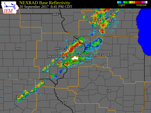
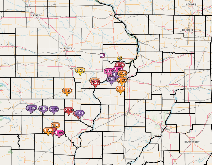
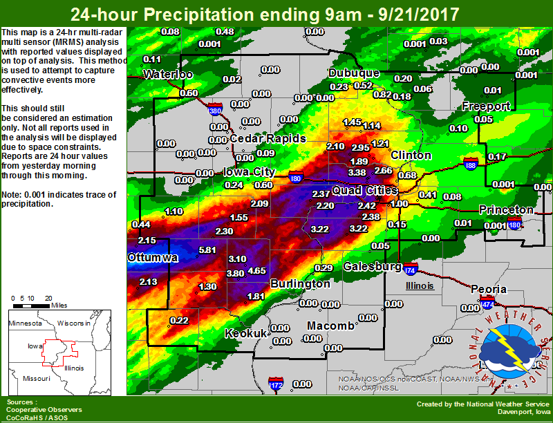
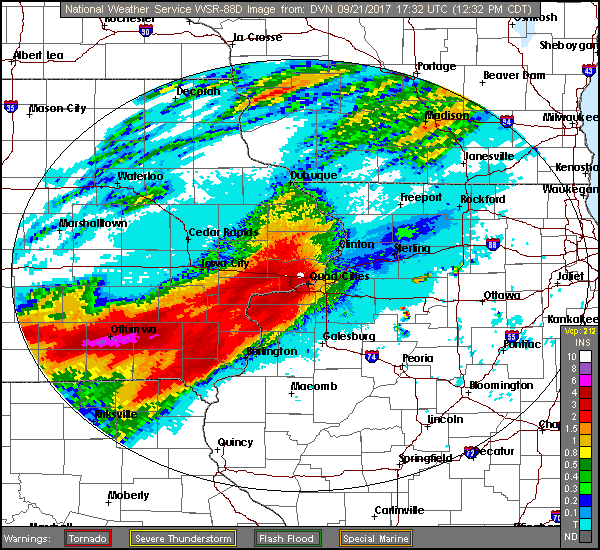
Scattered showers and thunderstorms moved across eastern Iowa, northwest Illinois, and far northeast Missouri during the evening of September 20th and the early morning of September 21st. Rainfall amounts ranged from zero at Cedar Rapids to 16 hundredths at Iowa City to 52 hundredths at Dubuque to 3.75 inches at Davenport. Rainfall amounts of 5 to 7 inches were reported in parts of Jefferson and Scott Counties. Twelve hour low temperatures ending at 7 am the morning of September 21 ranged from 64 degrees at Independence to 72 degrees at Keokuk. |
Storm Reports
| Interactive Storm Report Map | SPC Reports and Review |
 |
 |
|
PRELIMINARY LOCAL STORM REPORT...SUMMARY ..TIME... ...EVENT... ...CITY LOCATION... ...LAT.LON... 1138 AM HEAVY RAIN 4 W MOUNT PLEASANT 40.97N 91.63W EVENT TOTAL. 1131 AM HEAVY RAIN 3 ENE CHARLIE HEATH MEM 40.60N 91.84W EVENT TOTAL. NO WATER ISSUES. 1118 AM HEAVY RAIN 1 W BETTENDORF 41.56N 90.49W EVENT TOTAL. 1100 AM HEAVY RAIN DAVENPORT MUNICIPAL AIR 41.62N 90.58W STORM TOTAL RAINFALL PAST 24 HOURS 1100 AM HEAVY RAIN MOLINE QUAD-CITY AIRPOR 41.45N 90.50W STORM TOTAL RAINFALL PAST 24 HOURS 1059 AM HEAVY RAIN 4 WNW BETTENDORF 41.58N 90.55W 1029 AM HEAVY RAIN 1 SSE DAVENPORT 41.54N 90.60W 1025 AM HEAVY RAIN W CANTRIL 40.64N 92.07W 24 HOUR TOTAL. BIGGEST RAINFALL OF THE YEAR. 1011 AM HEAVY RAIN 1 NW DAVENPORT 41.56N 90.61W SILVER CREEK, NEAR HIS PROPERTY, WAS RUNNING 3/4 FULL. 1009 AM HEAVY RAIN E WALCOTT 41.59N 90.78W 1004 AM HEAVY RAIN 5 E CANTRIL 40.64N 91.98W EVENT TOTAL. 0938 AM HEAVY RAIN BATAVIA 40.99N 92.17W EVENT TOTAL. 0933 AM HEAVY RAIN 3 ENE CHARLIE HEATH MEM 40.60N 91.84W 0905 AM HEAVY RAIN 1 WSW SHERRARD 41.31N 90.53W EVENT TOTAL. 0900 AM HEAVY RAIN 2 ESE KEOSAUQUA 40.72N 91.92W 0900 AM HEAVY RAIN PARK VIEW 41.69N 90.54W 0852 AM HEAVY RAIN 2 SSE FAIRFIELD 40.98N 91.95W 0845 AM HEAVY RAIN 1 ESE NEW LONDON 40.92N 91.40W 0843 AM HEAVY RAIN 3 E WALCOTT 41.60N 90.72W EVENT TOTAL. 0813 AM HEAVY RAIN 4 W MOUNT PLEASANT 40.97N 91.63W 0804 AM HEAVY RAIN 3 E DAVENPORT 41.56N 90.55W STORM TOTAL THROUGH 730 AM. 0800 AM HEAVY RAIN ELDRIDGE 41.64N 90.57W 24 HOUR TOTAL. STILL RAINING. 0743 AM HEAVY RAIN 3 ENE CHARLIE HEATH MEM 40.60N 91.84W 2.10 INCHES FELL AFTER MIDNIGHT 0740 AM HEAVY RAIN 1 W BETTENDORF 41.56N 90.49W 0.97 FELL AFTER MIDNIGHT. 0730 AM HEAVY RAIN 3 NNW DAVENPORT 41.60N 90.63W PAST 12 HOURS 0730 AM HEAVY RAIN 1 SE DAVENPORT 41.54N 90.59W 0727 AM HEAVY RAIN 2 WSW DOWNEY 41.61N 91.39W 0705 AM HEAVY RAIN 1 ESE MUSCATINE 41.41N 91.06W EVENT TOTAL SO FAR. 0702 AM HEAVY RAIN WASHINGTON 41.28N 91.67W RELAYED BY KCRG 0701 AM HEAVY RAIN 1 SW DAVENPORT 41.55N 90.62W RAINFALL TOTAL FROM 8 PM CDT WEDNESDAY EVENING THROUGH 0649 AM HEAVY RAIN 2 NNW MUSCATINE 41.44N 91.08W 0638 AM HEAVY RAIN BUFFALO 41.46N 90.72W PUBLIC REPORT VIA TWITTER. RELAYED BY KWQC 0627 AM HEAVY RAIN 2 SW NEW LONDON 40.91N 91.43W 0144 AM FLASH FLOOD DAVENPORT 41.56N 90.60W VEHICLES STALLED WITH WATER UP TO THE DOORS AT THE 0109 AM HEAVY RAIN DAVENPORT MUNICIPAL AIR 41.62N 90.58W RAINFALL SINCE 7 PM. 1130 PM LIGHTNING DAVENPORT 41.56N 90.60W FIRE DEPARTMENT RESPONDED TO 3 LIGHTNING CAUSED BUILDING 0853 PM HEAVY RAIN 2 SSE DAVENPORT 41.53N 90.59W RAINFALL OVER PAST HOUR 0850 PM TSTM WND GST 4 SSW BETTENDORF 41.52N 90.51W MEASURED AT THE QUAD CITIES RWIS STATION 0846 PM HEAVY RAIN DAVENPORT 41.56N 90.60W RAINFALL SINCE EVENT BEGINNING 0845 PM HEAVY RAIN 5 SW DAVENPORT 41.51N 90.68W MEASURED NEAR HIGHWAY 280 AND HIGHWAY 61. 0836 PM TSTM WND DMG E DAVENPORT 41.56N 90.60W LARGE TREE DOWN ON KIRKWOOD BLVD. TIME OF THE EVENT WAS 0835 PM HAIL LOWDEN 41.86N 90.92W PEA TO DIME SIZE HAIL AND HEAVY RAIN. 0820 PM HAIL 3 SSW DAVENPORT 41.52N 90.62W 0807 PM TSTM WND GST DAVENPORT 41.56N 90.60W 0805 PM HAIL NW DAVENPORT 41.56N 90.60W HAIL FELL AT THE DAVENPORT MUNICIPAL AIRPORT FOR AROUND 4 0802 PM HAIL W DAVENPORT 41.56N 90.60W 0741 PM HAIL BLUE GRASS 41.51N 90.76W 0723 PM TSTM WND GST DEWITT 41.82N 90.55W MEASURED AT THE DEWITT IOWA RWIS STATION |
|
Rain Reports
| Local Rainfall Map | Radar Estimated Rainfall Map |
 |
 |
24 hour precipitation reports (in Inches), for eastern Iowa, northwest and west central Illinois, and northeast Missouri. Reported between Midnight and 9 AM, Thursday September 21, 2017. ....IOWA.... Davenport 0.9 SSW 6.53 Fairfield 5.81 Salem 3.1 ESE 4.65 Davenport 3.8 NNW 4.52 Davenport 0.9 WNW 4.14 Salem 1S 3.80 Davenport Arpt 3.75 Eldridge 0.6 S 3.55 Eldridge 0.6 ESE 3.44 Eldridge 0.7 SSW 3.38 Mt Pleasant 3.10 Calamus 2.0 NE 2.95 Park View 0.2 WSW 2.66 Albia 2.52 Muscatine 2N 2.37 Rathbun Reservoir 2.34 Brighton 2.30 Ottumwa ASOS 2.15 De Witt 4S 2.14 Bloomfield 2.13 Lowden 2.10 Ainsworth 7.4 N 2.09 De Witt 1.4 WNW 1.89 Donnellson 1.81 De Witt 1.65 Bettendorf 2.2 SE 1.57 Washington 1.55 Maquoketa 4W 1.45 Keosauqua 1.30 Le Claire LD14 1.25 Goose Lake 6.4 SSW 1.21 Delmar 2.3 NW 1.14 Sigourney 1.1 W 1.10 Centerville 0.88 Bellevue LD12 0.82 Le Claire 1.8 NNE 0.68 Mount Auburn 2.2 NNW 0.60 Iowa City 0.60 Dubuque Arpt 0.52 Pella 0.50 Fayette 0.48 Oskaloosa 0.48 Oskaloosa AWOS 0.44 Camanche 1.2 W 0.33 Pella AWOS 0.30 Dubuque #3 0.26 Kalona 7.3 NNW 0.24 Peosta 2.9 E 0.23 Beaconsfield 0.22 Iowa City Arpt 0.16 Marshalltown ASOS 0.12 Waterloo ASOS 0.11 Solon 0.3 ESE 0.09 Tripoli 0.08 Dubuque LD11 0.06 Burlington Arpt 0.06 Quasqueton 0.4 WSW 0.02 Marshalltown 0.02 Toledo 0.01 Oelwein AWOS 0.00 Monticello 0.00 Marion 1.2 NE 0.00 Cresco 0.00 Mason City 0.00 Marengo 0.00 Guttenberg Dam 10 0.00 Anamosa 3 SSW 0.00 Marion 1.7 NNW 0.00 Perry 0.00 Ames US 30 0.00 Cascade 0.00 Manchester 0.00 Hampton 0.00 Grinnell AWOS 0.00 Keokuk LD19 0.00 Mason City* 0.00 Parnell 0.1 SSW 0.00 Cedar Rapids 2.2 WSW 0.00 Belle Plaine 0.00 Cedar Rapids 3.4 NW 0.00 Central City 6.7 W 0.00 Mason City ASOS 0.00 Grinnell 0.00 Ely 0.5 SE 0.00 NWS Johnston* 0.00 Boone 0.00 Coggon 0.00 Amana 4.7 W 0.00 Williamsburg 0.00 Cedar Rapids Arpt 0.00 ....ILLINOIS.... Aledo 3.22 New Boston LD17 3.22 Moline 0.7 NNE 2.60 Moline 0.9 N 2.43 Moline 1.0 WNW 2.42 Milan 8.8 SSW 2.38 Ill. City LD16 2.20 Quad City Arpt 2.17 Coal Valley 1.9 SE 1.00 Geneseo 2.0 NW 0.41 Gladstone LD18 0.29 Galena 0.20 Hanover 0.2 NW 0.18 Rock Falls 0.17 New Windsor 2.0 N 0.15 Chadwick 2.7 WSW 0.10 Fulton 0.8 SSW 0.10 Atkinson 2.6 NNE 0.08 Elizabeth 0.06 Alexis 0.05 Rockford ASOS 0.05 Shannon 0.2 S 0.05 Kewanee 0.01 Freeport 2.0 NW 0.01 Roscoe 2SE 0.01 Davis 0.5 N 0.00 Freeport 0.00 Tiskilwa 2.1 N 0.00 Walnut 0.00 Windsor 0.00 Ottawa 0.00 Decatur Airport 0.00 Bentley 0.00 La Harpe 0.00 Mundelein 0.00 Romeoville 0.00 Galesburg 0.00 Rochelle AWOS 0.00 Princeton 1.1 SE 0.00 Augusta 0.00 Ogden 0.00 Princeton 0.00 Steward 0.00 Havana 0.00 Jacksonville AWOS 0.00 Dallas City 3.0 SSE 0.00 Joliet 0.00 Minonk 0.00 Quincy ASOS 0.00 Macomb 0.00 St Anne 0.00 Bloomington Airport 0.00 Tuscola 0.00 Mendota 0.00 Orangeville 2.8 NW 0.00 Warsaw 5.8 SE 0.00 Winslow 4.3 ESE 0.00 Prairie City 2S 0.00 Rochelle 0.00 Galesburg Arpt 0.00 Paw Paw 0.00 Peoria ASOS 0.00 Lincoln NWS 0.00 Altona 0.00 ....MISSOURI.... Memphis 0.22 Chillicothe 0.00 Columbia 0.00 Kirksville ASOS 0.00 ....WISCONSIN.... Allenton-WWTP 0.49 Madison-ASOS 0.39 La Crosse WFO 0.39 Viroqua 0.11 Watertown-AWOS 0.10 Sullivan-NWS 0.08 Prairie du Chien AWOS 0.05 Steuben 4SE 0.03 Darlington-2 NE 0.03 Darlington 0.00 Brodhead 0.00 Beloit-College 0.00 Whitewater 0.00 ....MINNESOTA.... Grand Meadow 0.00 Byron 4N 0.00 Theilman 1SSW 0.00 |
|
 |
Media use of NWS Web News Stories is encouraged! Please acknowledge the NWS as the source of any news information accessed from this site. |
|