Dangerous and extreme heat will remain across portions of the central U.S. this week, persisting across the mid to lower Mississippi Valley, Gulf Coast, southern Plains and portions of Texas. A heat wave over the Southwest U.S. will peak this weekend. Heavy to excessive rainfall may produce flash flooding from the Delmarva Peninsula north into the Hudson Valley today and tonight. Read More >
Overview
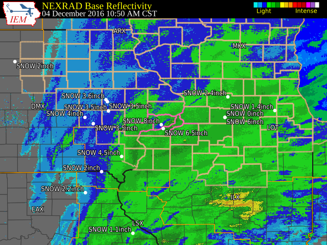
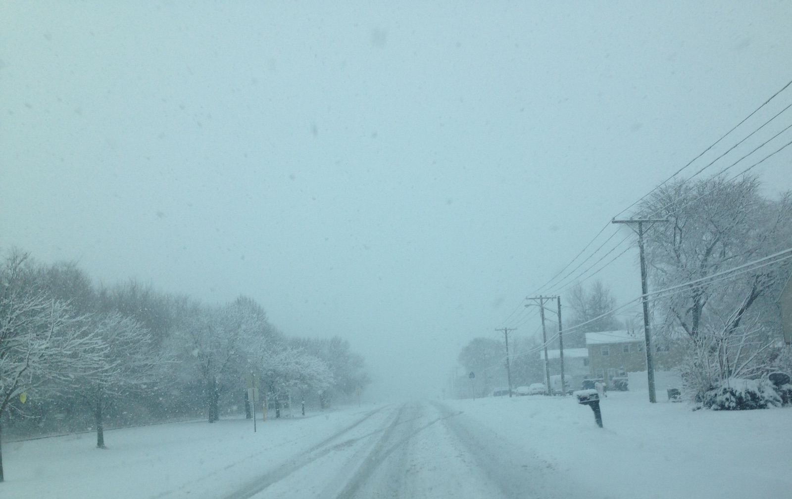
| The first snow storm of the season moved across the area Sunday, Dec. 4th, depositing widespread snowfall amounts of 6 to 10 inches over the entire Quad Cities metro area and much of northern Illinois. Elsewhere across the area snowfall amounts were generally between 3 and 6 inches. Temperatures topped out between 32 and 37 degrees area-wide. | 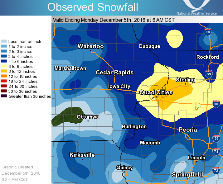 |
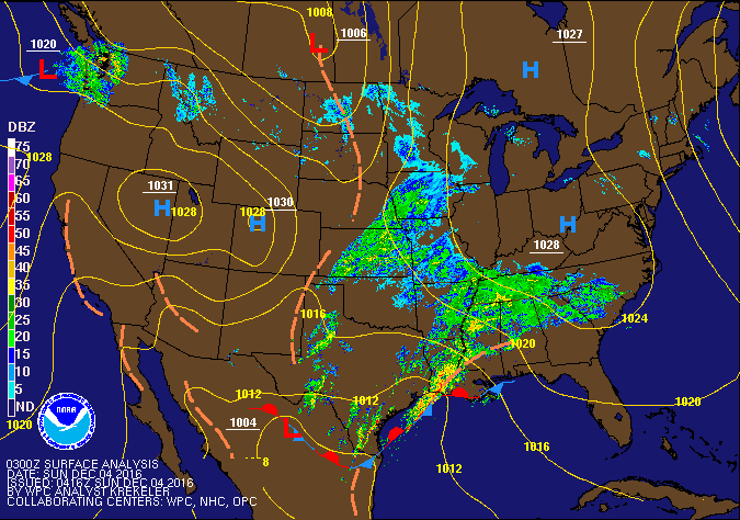 |
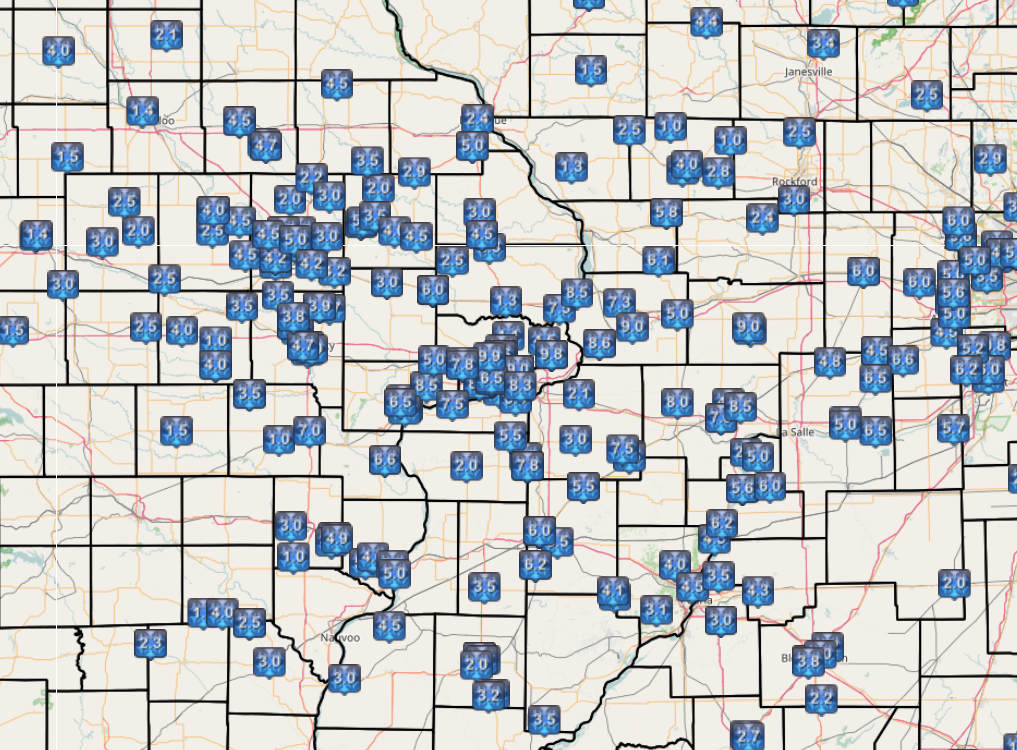
| 48-hr Observed Snowfall | WPC Fronts/Pressure/Radar Loop |
Snowfall Amounts
THE REPORTS BELOW ARE SEPARATED INTO SNOW...AND ICE AND SLEET CATEGORIES...THEN BY AMOUNT...AND ARE NOT NECESSARILY THE FINAL AMOUNT FOR EACH LOCATION. SNOW REPORTS LISTED BY AMOUNT INCHES LOCATION ST COUNTY TIME ------ ----------------------- -- -------------- ------- 10.2 DAVENPORT MUNICIPAL AIR IA SCOTT 0555 PM 9.9 4 NNW DAVENPORT IA SCOTT 0250 PM 9.8 PORT BYRON IL ROCK ISLAND 0300 PM 9.0 3 WSW BETTENDORF IA SCOTT 0130 PM 9.0 3 SSW DAVENPORT IA SCOTT 0130 PM 9.0 1 W BETTENDORF IA SCOTT 0135 PM 9.0 2 WSW DAVENPORT IA SCOTT 0215 PM 9.0 1 ENE LYNDON IL WHITESIDE 0317 PM 9.0 WSW MORRISON IL WHITESIDE 0400 PM 8.6 ESE ERIE IL WHITESIDE 0130 PM 8.5 2 ENE CLINTON IA CLINTON 0331 PM 8.5 MALDEN IL BUREAU 0340 PM 8.3 1 NNE MOLINE IL ROCK ISLAND 0250 PM 8.0 2 SW MANLIUS IL BUREAU 0250 PM 8.0 1 SE DAVENPORT IA SCOTT 0300 PM 8.0 2 SSE OSBORN IL HENRY 0400 PM 8.0 1 SSE DAVENPORT IA SCOTT 0515 PM 8.0 CAMANCHE IA CLINTON 0600 PM 8.0 3 ENE MUSCATINE IA MUSCATINE 0745 PM 8.0 4 NNW ALTONA IL HENRY 0824 PM 7.8 1 S WALCOTT IA SCOTT 0300 PM 7.8 1 ENE NEW WINDSOR IL HENRY 0330 PM 7.8 MOLINE QUAD-CITY AIRPOR IL ROCK ISLAND 0545 PM 7.5 SE WALCOTT IA SCOTT 0300 PM 7.3 1 WNW MORRISON IL WHITESIDE 0300 PM 7.1 2 SE COLONA IL HENRY 0815 PM 7.0 PRINCETON IL BUREAU 0319 PM 7.0 1 W CAMBRIDGE IL HENRY 0400 PM 7.0 ROCK FALLS IL WHITESIDE 0450 PM 6.9 2 NE FULTON IL WHITESIDE 0530 PM 6.7 7 NNW MOUNT CARROLL IL CARROLL 0400 PM 6.7 6 SSE ELMOVILLE IL CARROLL 0400 PM 6.6 4 NNE WAPELLO IA LOUISA 0215 PM 6.5 2 SSW DAVENPORT IA SCOTT 0250 PM 6.5 2 NNW MUSCATINE IA MUSCATINE 0300 PM 6.1 NNW MILLEDGEVILLE IL CARROLL 0330 PM 6.0 1 N BURLINGTON IA DES MOINES 0300 PM 6.0 LOWDEN IA CEDAR 0300 PM 6.0 6 N VARNA IL PUTNAM 0330 PM 6.0 2 SSE SCHAPVILLE IL JO DAVIESS 0345 PM 6.0 4 WSW LORAN IL JO DAVIESS 0415 PM 6.0 3 WNW EMERSON IL WHITESIDE 0421 PM 6.0 3 SSW BENNETT IA CEDAR 0730 PM 5.8 MIDDLETOWN IA DES MOINES 0240 PM 5.8 SSE SHANNON IL CARROLL 0325 PM 5.7 WALKER IA LINN 0300 PM 5.6 DUBUQUE REGIONAL AIRPOR IA DUBUQUE 0545 PM 5.5 ANAMOSA IA JONES 0110 PM 5.5 1 WSW SHERRARD IL MERCER 0215 PM 5.5 2 WNW FREEPORT IL STEPHENSON 0415 PM 5.5 1 SSW KEWANEE IL HENRY 0445 PM 5.5 1 W ELMIRA IA JOHNSON 0515 PM 5.5 SE WASHINGTON IA WASHINGTON 0539 PM 5.4 1 ENE ANAMOSA IA JONES 0130 PM 5.3 3 NNE STOCKTON IL JO DAVIESS 0600 PM 5.0 2 NW MARION IA LINN 0110 PM 5.0 SW DURANT IA CEDAR 0110 PM 5.0 1 ESE MUSCATINE IA MUSCATINE 0154 PM 5.0 2 SSE BURLINGTON IA DES MOINES 0224 PM 5.0 2 SSW PRAIRIEBURG IA LINN 0230 PM 5.0 FLORID IL PUTNAM 0310 PM 5.0 15 S MONROE IL STEPHENSON 0500 PM 5.0 5 NNW LANARK IL CARROLL 0517 PM 5.0 S CHADWICK IL CARROLL 0530 PM 5.0 SW MOUNT CARROLL IL CARROLL 0600 PM 4.9 1 ESE NEW LONDON IA HENRY 0130 PM 4.8 2 WNW DUBUQUE IA DUBUQUE 0712 PM 4.7 WSW QUASQUETON IA BUCHANAN 0115 PM 4.7 2 WSW IOWA CITY IA JOHNSON 0153 PM 4.5 2 ENE PALO IA LINN 0110 PM 4.5 E WYOMING IA JONES 0200 PM 4.5 2 NE COLUSA IL HANCOCK 0250 PM 4.5 1 S EDGEWOOD IA DELAWARE 0300 PM 4.5 SSE FREEPORT IL STEPHENSON 0600 PM 4.2 2 W CEDAR RAPIDS IA LINN 0110 PM 4.2 1 WSW IOWA CITY IA JOHNSON 0130 PM 4.2 1 ENE MOUNT VERNON IA LINN 0130 PM 4.2 NE BERTRAM IA LINN 0147 PM 4.0 MACOMB IL MCDONOUGH 0110 PM 4.0 1 SE VINTON IA BENTON 0110 PM 4.0 WNW PARNELL IA IOWA 0110 PM 4.0 2 SSE IOWA CITY IA JOHNSON 0140 PM 4.0 MACOMB IL MCDONOUGH 0200 PM 4.0 3 SSW CENTER JUNCTION IA JONES 0200 PM 4.0 6 WNW BURLINGTON IA DES MOINES 0300 PM 4.0 1 SSE MACOMB IL MCDONOUGH 0307 PM 4.0 2 WNW BURLINGTON IA DES MOINES 0400 PM 4.0 1 SSE CEDAR RAPIDS IA LINN 0509 PM 4.0 4 ENE FREEPORT IL STEPHENSON 0600 PM 3.8 2 NNW NORTH LIBERTY IA JOHNSON 0300 PM 3.8 5 NW CEDAR RAPIDS IA LINN 0450 PM 3.5 NE ROSEVILLE IL WARREN 0115 PM 3.5 4 ENE ANAMOSA IA JONES 0147 PM 3.2 2 WSW INDUSTRY IL MCDONOUGH 0130 PM 3.0 4 W MOUNT PLEASANT IA HENRY 0130 PM 3.0 SE STANWOOD IA CEDAR 0250 PM 3.0 1 ESE MACOMB IL MCDONOUGH 0300 PM 3.0 NNW SPRINGVILLE IA LINN 0331 PM 2.5 3 ENE CHARLIE HEATH MEM MO CLARK 0130 PM 2.5 BELLE PLAINE IA BENTON 0405 PM 2.2 NW BUSHNELL IL MCDONOUGH 0400 PM 2.0 2 SSW MACOMB IL MCDONOUGH 0319 PM |
|
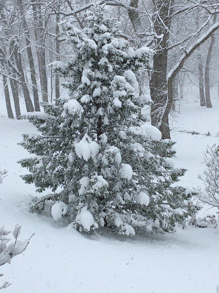
Photos:
 |
 |
 |
 |
| Park View, IA (Courtesy: Ray Wolf) |
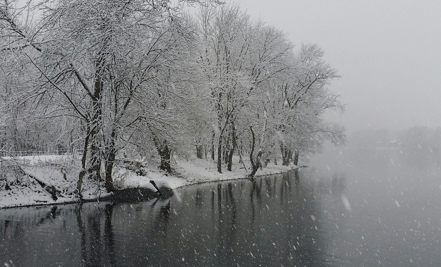
Rock River - Colona, IL (Courtesy: Dennis Becht) |
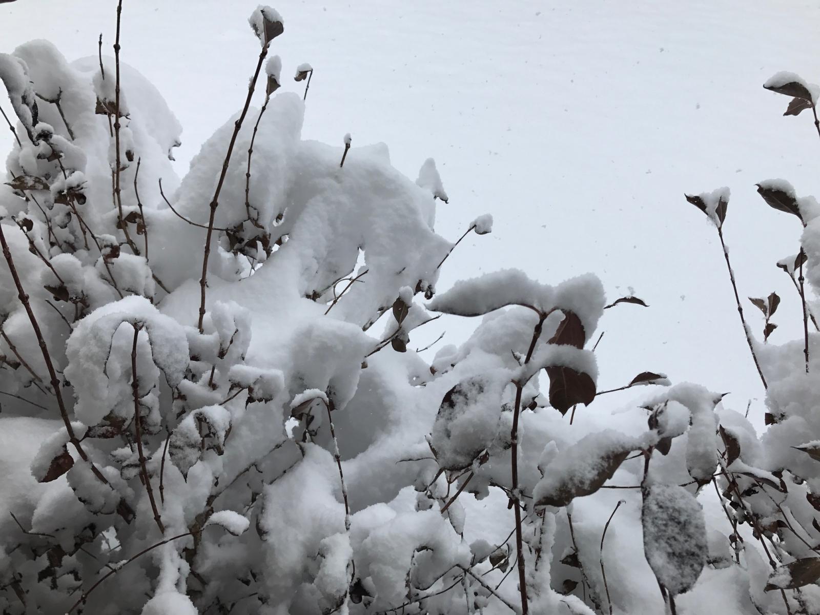
Eldridge, IA (Courtesy: Mike McClure) |
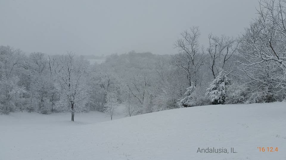
Andalusia, IL (Courtesy: Julie Strader) |
 |
 |
||
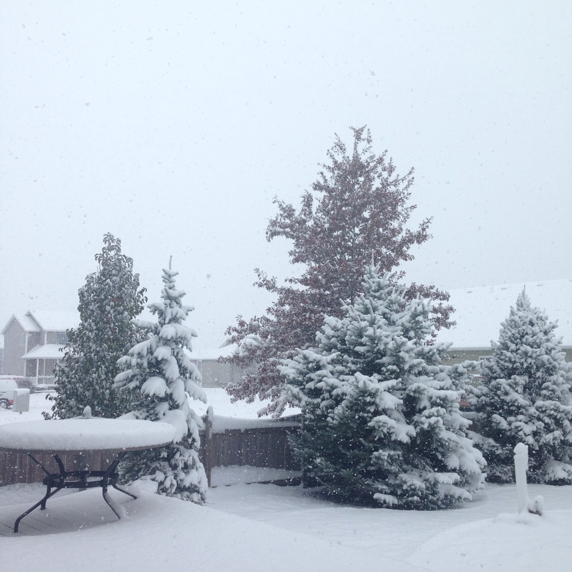
| Eldridge, IA (Courtesy: Tom Philip) |
Eldridge, IA (Courtesy: Tom Philip) |
Storm Reports
| * Interactive Map |
 |
PRELIMINARY LOCAL STORM REPORT...SUMMARY
NATIONAL WEATHER SERVICE QUAD CITIES IA IL
905 PM CST SUN DEC 04 2016
...SUMMARY LIST AT BOTTOM...
..TIME... ...EVENT... ...CITY LOCATION... ...LAT.LON...
..DATE... ....MAG.... ..COUNTY LOCATION..ST.. ...SOURCE....
..REMARKS..
0824 PM HEAVY SNOW 4 NNW ALTONA 41.17N 90.19W
12/04/2016 M8.0 INCH HENRY IL TRAINED SPOTTER
TOTAL
0815 PM SNOW 2 SE COLONA 41.47N 90.32W
12/04/2016 M7.1 INCH HENRY IL TRAINED SPOTTER
0745 PM HEAVY SNOW 3 ENE MUSCATINE 41.44N 91.03W
12/04/2016 M8.0 INCH MUSCATINE IA TRAINED SPOTTER
TOTAL
0730 PM HEAVY SNOW 3 SSW BENNETT 41.70N 90.99W
12/04/2016 M6.0 INCH CEDAR IA TRAINED SPOTTER
TOTAL
0712 PM SNOW 2 WNW DUBUQUE 42.52N 90.72W
12/04/2016 M4.8 INCH DUBUQUE IA TRAINED SPOTTER
0600 PM HEAVY SNOW CAMANCHE 41.79N 90.28W
12/04/2016 M8.0 INCH CLINTON IA OFFICIAL NWS OBS
CLINTON NUMBER 1 COOP. SNOWFALL TOTAL 8.0 INCHES. LIQUID
EQUIVALENT 0.56 INCHES. SNOW DEPTH 7 INCHES.
0600 PM SNOW 4 ENE FREEPORT 42.32N 89.57W
12/04/2016 M4.0 INCH STEPHENSON IL TRAINED SPOTTER
TOTAL
0600 PM SNOW SSE FREEPORT 42.29N 89.63W
12/04/2016 M4.5 INCH STEPHENSON IL PUBLIC
TOTAL
0600 PM SNOW 3 NNE STOCKTON 42.39N 89.98W
12/04/2016 M5.3 INCH JO DAVIESS IL CO-OP OBSERVER
TOTAL.
0600 PM SNOW SW MOUNT CARROLL 42.09N 89.98W
12/04/2016 M5.0 INCH CARROLL IL TRAINED SPOTTER
0555 PM HEAVY SNOW DAVENPORT MUNICIPAL AIR 41.62N 90.58W
12/04/2016 M10.2 INCH SCOTT IA OFFICIAL NWS OBS
UPDATED. EVENT TOTAL.
0545 PM SNOW DUBUQUE REGIONAL AIRPOR 42.40N 90.72W
12/04/2016 M5.6 INCH DUBUQUE IA OFFICIAL NWS OBS
UPDATED. EVENT TOTAL.
0545 PM HEAVY SNOW MOLINE QUAD-CITY AIRPOR 41.45N 90.50W
12/04/2016 M7.8 INCH ROCK ISLAND IL OFFICIAL NWS OBS
UPDATED. EVENT TOTAL.
0539 PM SNOW SE WASHINGTON 41.30N 91.69W
12/04/2016 M5.5 INCH WASHINGTON IA TRAINED SPOTTER
0530 PM SNOW 2 NE FULTON 41.89N 90.13W
12/04/2016 M6.9 INCH WHITESIDE IL TRAINED SPOTTER
0530 PM SNOW S CHADWICK 42.01N 89.89W
12/04/2016 M5.0 INCH CARROLL IL TRAINED SPOTTER
SNOW ENDED 3 PM.
0517 PM SNOW 5 NNW LANARK 42.17N 89.88W
12/04/2016 M5.0 INCH CARROLL IL TRAINED SPOTTER
0515 PM SNOW 1 SSE DAVENPORT 41.54N 90.60W
12/04/2016 M8.0 INCH SCOTT IA TRAINED SPOTTER
0515 PM SNOW 1 W ELMIRA 41.72N 91.44W
12/04/2016 M5.5 INCH JOHNSON IA TRAINED SPOTTER
0509 PM SNOW 1 SSE CEDAR RAPIDS 41.95N 91.66W
12/04/2016 M4.0 INCH LINN IA TRAINED SPOTTER
TOTAL
0500 PM SNOW 15 S MONROE 42.38N 89.64W
12/04/2016 M5.0 INCH STEPHENSON IL PUBLIC
TOTAL
0450 PM SNOW 5 NW CEDAR RAPIDS 42.03N 91.72W
12/04/2016 M3.8 INCH LINN IA TRAINED SPOTTER
TOTAL
0450 PM SNOW ROCK FALLS 41.77N 89.69W
12/04/2016 M7.0 INCH WHITESIDE IL TRAINED SPOTTER
STORM TOTAL. SNOW HAS ENDED.
0445 PM SNOW 1 SSW KEWANEE 41.23N 89.93W
12/04/2016 M5.5 INCH HENRY IL TRAINED SPOTTER
STORM TOTAL. SNOW HAS ENDED.
0421 PM HEAVY SNOW 3 WNW EMERSON 41.82N 89.82W
12/04/2016 M6.0 INCH WHITESIDE IL TRAINED SPOTTER
0415 PM SNOW 4 WSW LORAN 42.22N 89.99W
12/04/2016 M6.0 INCH JO DAVIESS IL TRAINED SPOTTER
STORM TOTAL.
0415 PM SNOW 2 WNW FREEPORT 42.30N 89.67W
12/04/2016 M5.5 INCH STEPHENSON IL TRAINED SPOTTER
EVENT TOTAL.
0405 PM SNOW BELLE PLAINE 41.90N 92.27W
12/04/2016 M2.5 INCH BENTON IA TRAINED SPOTTER
EVENT TOTAL.
0400 PM HEAVY SNOW 6 SSE ELMOVILLE 42.19N 90.02W
12/04/2016 M6.7 INCH CARROLL IL TRAINED SPOTTER
TOTAL
0400 PM HEAVY SNOW 7 NNW MOUNT CARROLL 42.19N 90.03W
12/04/2016 M6.7 INCH CARROLL IL COCORAHS
TOTAL
0400 PM HEAVY SNOW WSW MORRISON 41.81N 89.97W
12/04/2016 M9.0 INCH WHITESIDE IL TRAINED SPOTTER
0400 PM HEAVY SNOW 2 SSE OSBORN 41.49N 90.25W
12/04/2016 M8.0 INCH HENRY IL TRAINED SPOTTER
0400 PM HEAVY SNOW 1 W CAMBRIDGE 41.30N 90.20W
12/04/2016 M7.0 INCH HENRY IL TRAINED SPOTTER
0400 PM SNOW 2 WNW BURLINGTON 40.83N 91.16W
12/04/2016 M4.0 INCH DES MOINES IA TRAINED SPOTTER
0400 PM SNOW NW BUSHNELL 40.56N 90.51W
12/04/2016 E2.2 INCH MCDONOUGH IL TRAINED SPOTTER
0345 PM HEAVY SNOW 2 SSE SCHAPVILLE 42.37N 90.18W
12/04/2016 M6.0 INCH JO DAVIESS IL TRAINED SPOTTER
0340 PM HEAVY SNOW MALDEN 41.42N 89.37W
12/04/2016 M8.5 INCH BUREAU IL TRAINED SPOTTER
EVENT TOTAL SO FAR...JUST LIGHT SNOW FALLING AT TIME OF
REPORT. 4.5 INCHES OF TOTAL FELL SINCE 11 AM CST THIS
MORNING.
0331 PM SNOW NNW SPRINGVILLE 42.06N 91.45W
12/04/2016 E3.0 INCH LINN IA TRAINED SPOTTER
ELEVATED AREAS HAD 2.4 INCHES WHILE GRASSY AREAS HAD
ABOUT 4.2 INCHES.
0331 PM HEAVY SNOW 2 ENE CLINTON 41.85N 90.19W
12/04/2016 M8.5 INCH CLINTON IA TRAINED SPOTTER
TOTAL
0330 PM HEAVY SNOW 1 ENE NEW WINDSOR 41.20N 90.44W
12/04/2016 M7.8 INCH HENRY IL TRAINED SPOTTER
TOTAL
0330 PM HEAVY SNOW NNW MILLEDGEVILLE 41.97N 89.78W
12/04/2016 M6.1 INCH CARROLL IL TRAINED SPOTTER
TOTAL
0330 PM SNOW 6 N VARNA 41.12N 89.22W
12/04/2016 M6.0 INCH PUTNAM IL TRAINED SPOTTER
EVENT TOTAL SO FAR...JUST LIGHT SNOW FALLING AT TIME OF
REPORT.
0325 PM SNOW SSE SHANNON 42.15N 89.74W
12/04/2016 M5.8 INCH CARROLL IL TRAINED SPOTTER
TOTAL. COCORAHS OBSERVER TOO.
0319 PM SNOW PRINCETON 41.38N 89.47W
12/04/2016 M7.0 INCH BUREAU IL CO-OP OBSERVER
EVENT TOTAL SO FAR...STILL LIGHT SNOW FALLING AT TIME OF
REPORT.
0319 PM SNOW 2 SSW MACOMB 40.44N 90.70W
12/04/2016 M2.0 INCH MCDONOUGH IL TRAINED SPOTTER
TOTAL
0317 PM HEAVY SNOW 1 ENE LYNDON 41.72N 89.91W
12/04/2016 E9.0 INCH WHITESIDE IL TRAINED SPOTTER
TOTAL
0310 PM SNOW FLORID 41.23N 89.28W
12/04/2016 M5.0 INCH PUTNAM IL PUBLIC
SO FAR
0307 PM SNOW 1 SSE MACOMB 40.46N 90.67W
12/04/2016 M4.0 INCH MCDONOUGH IL TRAINED SPOTTER
TOTAL
0300 PM SNOW 6 WNW BURLINGTON 40.85N 91.22W
12/04/2016 M4.0 INCH DES MOINES IA TRAINED SPOTTER
TOTAL
0300 PM HEAVY SNOW 1 S WALCOTT 41.58N 90.77W
12/04/2016 E7.8 INCH SCOTT IA TRAINED SPOTTER
TOTAL
0300 PM SNOW 1 ESE MACOMB 40.46N 90.66W
12/04/2016 M3.0 INCH MCDONOUGH IL TRAINED SPOTTER
EVENT TOTAL.
0300 PM HEAVY SNOW PORT BYRON 41.62N 90.32W
12/04/2016 M9.8 INCH ROCK ISLAND IL TRAINED SPOTTER
EVENT TOTAL.
0300 PM SNOW 2 NNW NORTH LIBERTY 41.76N 91.62W
12/04/2016 M3.8 INCH JOHNSON IA TRAINED SPOTTER
TOTAL
0300 PM HEAVY SNOW SE WALCOTT 41.59N 90.77W
12/04/2016 M7.5 INCH SCOTT IA TRAINED SPOTTER
TOTAL.
0300 PM SNOW 1 WNW MORRISON 41.81N 89.98W
12/04/2016 M7.3 INCH WHITESIDE IL TRAINED SPOTTER
SNOW REPORTED TO BE WINDING DOWN.
0300 PM SNOW 1 S EDGEWOOD 42.63N 91.40W
12/04/2016 M4.5 INCH DELAWARE IA TRAINED SPOTTER
TOTAL
0300 PM SNOW WALKER 42.29N 91.78W
12/04/2016 M5.7 INCH LINN IA PUBLIC
0300 PM HEAVY SNOW 1 SE DAVENPORT 41.54N 90.59W
12/04/2016 M8.0 INCH SCOTT IA TRAINED SPOTTER
0300 PM HEAVY SNOW LOWDEN 41.86N 90.92W
12/04/2016 M6.0 INCH CEDAR IA CO-OP OBSERVER
TOTAL
0300 PM HEAVY SNOW 2 NNW MUSCATINE 41.44N 91.08W
12/04/2016 M6.5 INCH MUSCATINE IA TRAINED SPOTTER
TOTAL
0300 PM SNOW 1 N BURLINGTON 40.82N 91.12W
12/04/2016 M6.0 INCH DES MOINES IA TRAINED SPOTTER
TOTAL. MELTING FAST.
0250 PM HEAVY SNOW 4 NNW DAVENPORT 41.61N 90.63W
12/04/2016 M9.9 INCH SCOTT IA NWS EMPLOYEE
STORM TOTAL SNOWFALL 9.9 INCHES. LIQUID 0.61 INCHES. 16
TO 1 SNOW TO LIQUID RATIO.
0250 PM SNOW 1 NNE MOLINE 41.50N 90.48W
12/04/2016 M8.3 INCH ROCK ISLAND IL NWS EMPLOYEE
TOTAL
0250 PM HEAVY SNOW 2 SSW DAVENPORT 41.53N 90.62W
12/04/2016 M6.5 INCH SCOTT IA TRAINED SPOTTER
TOTAL
0250 PM SNOW 2 NE COLUSA 40.59N 91.14W
12/04/2016 M4.5 INCH HANCOCK IL TRAINED SPOTTER
TOTAL
0250 PM SNOW SE STANWOOD 41.89N 91.15W
12/04/2016 M3.0 INCH CEDAR IA TRAINED SPOTTER
TOTAL.
0250 PM HEAVY SNOW 2 SW MANLIUS 41.44N 89.69W
12/04/2016 M8.0 INCH BUREAU IL TRAINED SPOTTER
STILL SNOWING
0240 PM SNOW MIDDLETOWN 40.83N 91.26W
12/04/2016 M5.8 INCH DES MOINES IA PUBLIC
TOTAL
0230 PM SNOW 2 SSW PRAIRIEBURG 42.21N 91.44W
12/04/2016 M5.0 INCH LINN IA TRAINED SPOTTER
TOTAL. LATE REPORT.
0224 PM SNOW 2 SSE BURLINGTON 40.79N 91.11W
12/04/2016 M5.0 INCH DES MOINES IA TRAINED SPOTTER
TOTAL.
0215 PM SNOW 1 WSW SHERRARD 41.31N 90.53W
12/04/2016 M5.5 INCH MERCER IL TRAINED SPOTTER
EVENT TOTAL
0215 PM HEAVY SNOW 4 NNE WAPELLO 41.22N 91.16W
12/04/2016 M6.6 INCH LOUISA IA TRAINED SPOTTER
EVENT TOTAL
0215 PM HEAVY SNOW 2 WSW DAVENPORT 41.54N 90.63W
12/04/2016 M9.0 INCH SCOTT IA TRAINED SPOTTER
TOTAL
0200 PM SNOW 3 SSW CENTER JUNCTION 42.08N 91.11W
12/04/2016 M4.0 INCH JONES IA TRAINED SPOTTER
TOTAL
0200 PM SNOW E WYOMING 42.06N 91.00W
12/04/2016 M4.5 INCH JONES IA TRAINED SPOTTER
TOTAL
0200 PM SNOW MACOMB 40.47N 90.68W
12/04/2016 M4.0 INCH MCDONOUGH IL PUBLIC
SOCIAL MEDIA PHOTO POST OF SNOWFALL MEASURED ON DECK
RAILING/ELEVATED SURFACE.
0154 PM SNOW 1 ESE MUSCATINE 41.41N 91.06W
12/04/2016 M5.0 INCH MUSCATINE IA TRAINED SPOTTER
TOTAL
0153 PM SNOW 2 WSW IOWA CITY 41.65N 91.57W
12/04/2016 M4.7 INCH JOHNSON IA TRAINED SPOTTER
TOTAL
0147 PM SNOW NE BERTRAM 41.96N 91.53W
12/04/2016 M4.2 INCH LINN IA TRAINED SPOTTER
TOTAL.
0147 PM SNOW 4 ENE ANAMOSA 42.14N 91.21W
12/04/2016 M3.5 INCH JONES IA TRAINED SPOTTER
TOTAL.
0140 PM SNOW 2 SSE IOWA CITY 41.64N 91.53W
12/04/2016 M4.0 INCH JOHNSON IA TRAINED SPOTTER
TOTAL.
0135 PM HEAVY SNOW 1 W BETTENDORF 41.56N 90.49W
12/04/2016 M9.0 INCH SCOTT IA TRAINED SPOTTER
SO FAR
0130 PM SNOW 2 WSW INDUSTRY 40.32N 90.64W
12/04/2016 M3.2 INCH MCDONOUGH IL TRAINED SPOTTER
0130 PM SNOW 1 ENE MOUNT VERNON 41.93N 91.41W
12/04/2016 M4.2 INCH LINN IA TRAINED SPOTTER
JUST ABOUT DONE.
0130 PM SNOW 3 ENE CHARLIE HEATH MEM 40.60N 91.84W
12/04/2016 M2.5 INCH CLARK MO TRAINED SPOTTER
EVENT TOTAL.
0130 PM HEAVY SNOW 3 SSW DAVENPORT 41.52N 90.62W
12/04/2016 M9.0 INCH SCOTT IA TRAINED SPOTTER
TOTAL SO FAR
0130 PM SNOW 1 ENE ANAMOSA 42.12N 91.27W
12/04/2016 M5.4 INCH JONES IA TRAINED SPOTTER
STORM TOTAL.
0130 PM SNOW 1 WSW IOWA CITY 41.65N 91.55W
12/04/2016 M4.2 INCH JOHNSON IA TRAINED SPOTTER
EVENT TOTAL.
0130 PM SNOW 1 ESE NEW LONDON 40.92N 91.40W
12/04/2016 M4.9 INCH HENRY IA TRAINED SPOTTER
SNOW PRETTY MUCH OVER. ALSO COCORAHS OBSERVER.
0130 PM HEAVY SNOW 3 WSW BETTENDORF 41.55N 90.52W
12/04/2016 M9.0 INCH SCOTT IA TRAINED SPOTTER
0130 PM HEAVY SNOW ESE ERIE 41.66N 90.08W
12/04/2016 M8.6 INCH WHITESIDE IL TRAINED SPOTTER
SNOW CONTINUES TO FALL.
0130 PM SNOW 4 W MOUNT PLEASANT 40.97N 91.63W
12/04/2016 M3.0 INCH HENRY IA TRAINED SPOTTER
TOTAL
0115 PM SNOW WSW QUASQUETON 42.40N 91.76W
12/04/2016 M4.7 INCH BUCHANAN IA COCORAHS
TOTAL
0115 PM SNOW NE ROSEVILLE 40.74N 90.66W
12/04/2016 M3.5 INCH WARREN IL TRAINED SPOTTER
0110 PM SNOW WNW PARNELL 41.58N 92.01W
12/04/2016 M4.0 INCH IOWA IA TRAINED SPOTTER
TOTAL
0110 PM SNOW 1 SE VINTON 42.16N 92.02W
12/04/2016 M4.0 INCH BENTON IA TRAINED SPOTTER
TOTAL
0110 PM SNOW 2 W CEDAR RAPIDS 41.98N 91.71W
12/04/2016 M4.2 INCH LINN IA TRAINED SPOTTER
TOTAL
0110 PM SNOW ANAMOSA 42.11N 91.28W
12/04/2016 M5.5 INCH JONES IA TRAINED SPOTTER
JUST ABOUT DONE
0110 PM SNOW SW DURANT 41.60N 90.91W
12/04/2016 M5.0 INCH CEDAR IA TRAINED SPOTTER
AT LEAST 5 INCHES.
0110 PM SNOW 2 NW MARION 42.05N 91.61W
12/04/2016 M5.0 INCH LINN IA TRAINED SPOTTER
0110 PM SNOW 2 ENE PALO 42.07N 91.75W
12/04/2016 M4.5 INCH LINN IA TRAINED SPOTTER
TOTAL
0110 PM SNOW MACOMB 40.47N 90.68W
12/04/2016 M4.0 INCH MCDONOUGH IL TRAINED SPOTTER
JUST ABOUT DONE. MEASURED ON PARK BENCH IN THE OPEN.
&&
THE REPORTS BELOW ARE SEPARATED INTO SNOW...AND ICE AND SLEET
CATEGORIES...THEN BY AMOUNT...AND ARE NOT NECESSARILY THE
FINAL AMOUNT FOR EACH LOCATION.
SNOW REPORTS LISTED BY AMOUNT
INCHES LOCATION ST COUNTY TIME
------ ----------------------- -- -------------- -------
10.2 DAVENPORT MUNICIPAL AIR IA SCOTT 0555 PM
9.9 4 NNW DAVENPORT IA SCOTT 0250 PM
9.8 PORT BYRON IL ROCK ISLAND 0300 PM
9.0 3 WSW BETTENDORF IA SCOTT 0130 PM
9.0 3 SSW DAVENPORT IA SCOTT 0130 PM
9.0 1 W BETTENDORF IA SCOTT 0135 PM
9.0 2 WSW DAVENPORT IA SCOTT 0215 PM
9.0 1 ENE LYNDON IL WHITESIDE 0317 PM
9.0 WSW MORRISON IL WHITESIDE 0400 PM
8.6 ESE ERIE IL WHITESIDE 0130 PM
8.5 2 ENE CLINTON IA CLINTON 0331 PM
8.5 MALDEN IL BUREAU 0340 PM
8.3 1 NNE MOLINE IL ROCK ISLAND 0250 PM
8.0 2 SW MANLIUS IL BUREAU 0250 PM
8.0 1 SE DAVENPORT IA SCOTT 0300 PM
8.0 2 SSE OSBORN IL HENRY 0400 PM
8.0 1 SSE DAVENPORT IA SCOTT 0515 PM
8.0 CAMANCHE IA CLINTON 0600 PM
8.0 3 ENE MUSCATINE IA MUSCATINE 0745 PM
8.0 4 NNW ALTONA IL HENRY 0824 PM
7.8 1 S WALCOTT IA SCOTT 0300 PM
7.8 1 ENE NEW WINDSOR IL HENRY 0330 PM
7.8 MOLINE QUAD-CITY AIRPOR IL ROCK ISLAND 0545 PM
7.5 SE WALCOTT IA SCOTT 0300 PM
7.3 1 WNW MORRISON IL WHITESIDE 0300 PM
7.1 2 SE COLONA IL HENRY 0815 PM
7.0 PRINCETON IL BUREAU 0319 PM
7.0 1 W CAMBRIDGE IL HENRY 0400 PM
7.0 ROCK FALLS IL WHITESIDE 0450 PM
6.9 2 NE FULTON IL WHITESIDE 0530 PM
6.7 7 NNW MOUNT CARROLL IL CARROLL 0400 PM
6.7 6 SSE ELMOVILLE IL CARROLL 0400 PM
6.6 4 NNE WAPELLO IA LOUISA 0215 PM
6.5 2 SSW DAVENPORT IA SCOTT 0250 PM
6.5 2 NNW MUSCATINE IA MUSCATINE 0300 PM
6.1 NNW MILLEDGEVILLE IL CARROLL 0330 PM
6.0 1 N BURLINGTON IA DES MOINES 0300 PM
6.0 LOWDEN IA CEDAR 0300 PM
6.0 6 N VARNA IL PUTNAM 0330 PM
6.0 2 SSE SCHAPVILLE IL JO DAVIESS 0345 PM
6.0 4 WSW LORAN IL JO DAVIESS 0415 PM
6.0 3 WNW EMERSON IL WHITESIDE 0421 PM
6.0 3 SSW BENNETT IA CEDAR 0730 PM
5.8 MIDDLETOWN IA DES MOINES 0240 PM
5.8 SSE SHANNON IL CARROLL 0325 PM
5.7 WALKER IA LINN 0300 PM
5.6 DUBUQUE REGIONAL AIRPOR IA DUBUQUE 0545 PM
5.5 ANAMOSA IA JONES 0110 PM
5.5 1 WSW SHERRARD IL MERCER 0215 PM
5.5 2 WNW FREEPORT IL STEPHENSON 0415 PM
5.5 1 SSW KEWANEE IL HENRY 0445 PM
5.5 1 W ELMIRA IA JOHNSON 0515 PM
5.5 SE WASHINGTON IA WASHINGTON 0539 PM
5.4 1 ENE ANAMOSA IA JONES 0130 PM
5.3 3 NNE STOCKTON IL JO DAVIESS 0600 PM
5.0 2 NW MARION IA LINN 0110 PM
5.0 SW DURANT IA CEDAR 0110 PM
5.0 1 ESE MUSCATINE IA MUSCATINE 0154 PM
5.0 2 SSE BURLINGTON IA DES MOINES 0224 PM
5.0 2 SSW PRAIRIEBURG IA LINN 0230 PM
5.0 FLORID IL PUTNAM 0310 PM
5.0 15 S MONROE IL STEPHENSON 0500 PM
5.0 5 NNW LANARK IL CARROLL 0517 PM
5.0 S CHADWICK IL CARROLL 0530 PM
5.0 SW MOUNT CARROLL IL CARROLL 0600 PM
4.9 1 ESE NEW LONDON IA HENRY 0130 PM
4.8 2 WNW DUBUQUE IA DUBUQUE 0712 PM
4.7 WSW QUASQUETON IA BUCHANAN 0115 PM
4.7 2 WSW IOWA CITY IA JOHNSON 0153 PM
4.5 2 ENE PALO IA LINN 0110 PM
4.5 E WYOMING IA JONES 0200 PM
4.5 2 NE COLUSA IL HANCOCK 0250 PM
4.5 1 S EDGEWOOD IA DELAWARE 0300 PM
4.5 SSE FREEPORT IL STEPHENSON 0600 PM
4.2 2 W CEDAR RAPIDS IA LINN 0110 PM
4.2 1 WSW IOWA CITY IA JOHNSON 0130 PM
4.2 1 ENE MOUNT VERNON IA LINN 0130 PM
4.2 NE BERTRAM IA LINN 0147 PM
4.0 MACOMB IL MCDONOUGH 0110 PM
4.0 1 SE VINTON IA BENTON 0110 PM
4.0 WNW PARNELL IA IOWA 0110 PM
4.0 2 SSE IOWA CITY IA JOHNSON 0140 PM
4.0 MACOMB IL MCDONOUGH 0200 PM
4.0 3 SSW CENTER JUNCTION IA JONES 0200 PM
4.0 6 WNW BURLINGTON IA DES MOINES 0300 PM
4.0 1 SSE MACOMB IL MCDONOUGH 0307 PM
4.0 2 WNW BURLINGTON IA DES MOINES 0400 PM
4.0 1 SSE CEDAR RAPIDS IA LINN 0509 PM
4.0 4 ENE FREEPORT IL STEPHENSON 0600 PM
3.8 2 NNW NORTH LIBERTY IA JOHNSON 0300 PM
3.8 5 NW CEDAR RAPIDS IA LINN 0450 PM
3.5 NE ROSEVILLE IL WARREN 0115 PM
3.5 4 ENE ANAMOSA IA JONES 0147 PM
3.2 2 WSW INDUSTRY IL MCDONOUGH 0130 PM
3.0 4 W MOUNT PLEASANT IA HENRY 0130 PM
3.0 SE STANWOOD IA CEDAR 0250 PM
3.0 1 ESE MACOMB IL MCDONOUGH 0300 PM
3.0 NNW SPRINGVILLE IA LINN 0331 PM
2.5 3 ENE CHARLIE HEATH MEM MO CLARK 0130 PM
2.5 BELLE PLAINE IA BENTON 0405 PM
2.2 NW BUSHNELL IL MCDONOUGH 0400 PM
2.0 2 SSW MACOMB IL MCDONOUGH 0319 PM
|
Additional Information
 |
 |
|
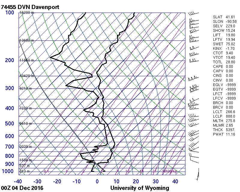
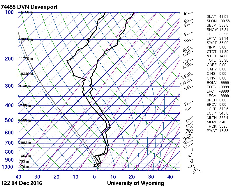
| DVN Sounding 12/4/16 00z | DVN Sounding 12/4/16 12z |
Summaries from other NWS Offices
 |
Media use of NWS Web News Stories is encouraged! Please acknowledge the NWS as the source of any news information accessed from this site. |
|