Meteorological Factors Leading up to the Flood of 2008
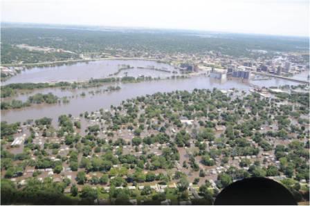
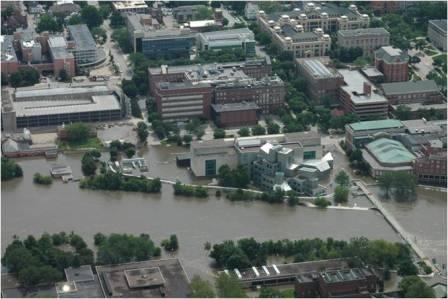
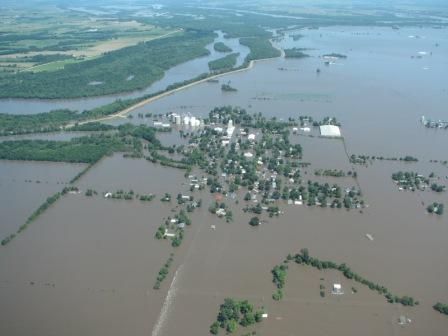
The culmination of many above normal to record meteorological factors, from the winter of 2007-2008 through the spring of 2008, led to the historic Midwest Flood of June 2008. Locally this flood might be most remembered for its devastating impacts in the Cedar Rapids, Iowa City, Oakville, and Gulfport areas.
|
Key Contributing factors to the Historic Flooding of 2008: Heavy winter snow (from late 2007 through early 2008) + Significant flooding in April 2008 (resulting in high river levels) + Extremely moist soils (continuing through May) + Heavy June rains => Historic flooding |
|


Record River Crest Levels: Updated 10:00 am 6/22/08
                      FLOOD   RECORD
LOCATION           STAGE    STAGE     DATE                   PRELIMINARY CRESTS
----------------------------------------------------------------------------------------
MISSISSIPPI RIVER
 DUBUQUE LD11        16   25.69 FT  04/26/1965
 DUBUQUE             17   26.81 FT  04/26/1965
 BELLEVUE LD12       17   23.51 FT  04/26/1965
 FULTON LD13         16   25.30 FT  04/28/1965
 CAMANCHE            17   24.65 FT  04/28/1965
 LE CLAIRE LD14      11   17.75 FT  04/28/1965
 ROCK ISLAND LD15    15   22.63 FT  07/09/1993
 ILL. CITY LD16      15   24.10 FT  07/09/1993
 MUSCATINE           16   25.61 FT  07/09/1993
 NEW BOSTON LD17     15   25.90 FT  07/09/1993    Est. 25.05 FT around  noon on 6/17/2008
 KEITHSBURG          14   24.15 FT  07/09/1993    Est. 24.50 FT around 10:00 am 6/17/2008
 GLADSTONE LD18      10   21.54 FT  07/10/1993    Est. 22.26 FT around  4:00 am 6/17/2008
 BURLINGTON          15   25.10 FT  07/10/1993    Est. 25.73 FT around  3:30 am 6/17/2008
 KEOKUK LD19         16   27.58 FT  07/10/1993    Est. 26.92 FT around  2:00 pm 6/17/2008
 GREGORY LANDING     15   28.49 FT  07/09/1993    Unknown
MAQUOKETA RIVER
 MAQUOKETA           24   34.09 FT  06/05/2002
WAPSIPINICON RIVER
 INDEPENDENCE        12   22.35 FT  05/18/1999
 ANAMOSA SHAW RD     14   22.73 FT  05/26/2004    Est. 26.18 FT around  4:30 am 6/13/2008
 DE WITT             11   14.19 FT  06/17/1990    Est. 14.13 FT around 10:30 am 6/16/2008
CEDAR RIVER
 VINTON              15   19.30 FT  03/30/1961    Est. 24.70 FT around 10:00 pm 6/12/2008
 CEDAR RAPIDS        12   20.00 FT  03/18/1929    Est. 31.12 FT around 10:15 am 6/13/2008
 CONESVILLE          13   17.11 FT  04/06/1993    Est. 23.40 FT around  3:00 am 6/15/2008
IOWA RIVER
 MARENGO             14   20.31 FT  07/19/1993    Est. 21.40 FT around 10:00 pm 6/12/2008
 IOWA CITY           22   28.52 FT  08/10/1993    Est. 31.53 FT around  6:30 am 6/15/2008
 LONE TREE           15   22.94 FT  07/07/1993    Est. 23.10 FT around  5:00 pm 6/15/2008
 COLUMBUS JCT        19   28.30 FT  07/07/1993    Est. 32.30 FT around  1:00 am 6/15/2008

 WAPELLO             20   29.53 FT  07/07/1993    Est. 32.15 FT around 12:30 pm 6/14/2008
ENGLISH RIVER
 KALONA              14   22.55 FT  07/06/1993
SKUNK RIVER
 SIGOURNEY           16   25.33 FT  03/31/1960
 AUGUSTA             15   27.05 FT  04/23/1973
DES MOINES RIVER
 KEOSAUQUA           22   32.66 FT  07/13/1993
 ST FRANCISVILLE     18   32.02 FT  07/15/1993
PECATONICA RIVER
 FREEPORT            13   19.76 FT  03/16/1929
ROCK RIVER
 COMO                10   19.60 FT  02/16/1918
 JOSLIN              12   19.24 FT  06/07/2002
 MOLINE              12   16.38 FT  03/06/2008
GREEN RIVER
 GENESEO             15   18.77 FT  10/18/1998
LA MOINES RIVER
 COLMAR              20   27.03 FT  01/03/1965
FOX RIVER
 WAYLAND             15   21.71 FT  04/22/1973
For more river information, please call 563-386-3976.
|
|
|
River and Flood Related Links:
Flood Safety and Flood Information: https://www.floodsafety.noaa.gov/
U.S. Geological Survey Water Data: https://water.usgs.gov/
U.S. Army Corps of Engineers Water Levels: https://www.rivergages.com/
Rebuild Iowa Office: https://www.rio.iowa.gov/
"Be Ready Iowa": https://www.bereadyiowa.org/
"Ready Illinois": https://www.ready.illinois.gov/