Canadian wildfire smoke will push into the Midwest, worsening air quality. A frontal system brings severe storms from the Northern Plains to the Mid‑Atlantic the next few days. Heavy Gulf Coast rain is possible as we closely monitor tropical development, while monsoonal storms persist in the Southwest with heavy rainfall. Hazardous heat expands from the Plains into the Lower Mississippi Valley. Read More >
Overview
|
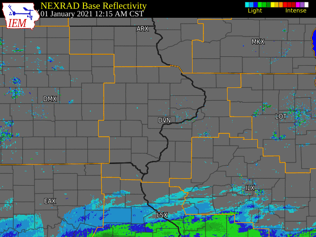
A weaker winter storm moved into the area and added more ice and snow to the snow pack received the other day. This system moved in from the south and brought along a strong pull of warm air aloft. This led to a lot more ice accumulation than was expected prior to the event. While the storm was supposed to lead to mostly snow for the northern half of our forecast area, those areas received mainly freezing rain and sleet through most of the afternoon. This led to widespread ice accumulations of 0.10-0.25". In the southwest part of our forecast area, more ice accumulation was noted, with many locations reporting around 0.25" or even more. Along with the accumulating ice, some downed tree limbs and power outages were a result. Mid afternoon, the freezing rain began to switch to snow from a line around Iowa City, IA to Freeport, IL. A relatively strong band formed in this location and dropped around 4" of snow, especially in the Iowa City area. This band slowly progressed towards the east through the rest of the afternoon and evening, with another band setting up just east of the Mississippi, where reports around 3" were noted in the Moline area. Overall, these were relatively light snowfall accumulations, but when coupled with the ice that fell prior, it led to treacherous driving conditions throughout the area.
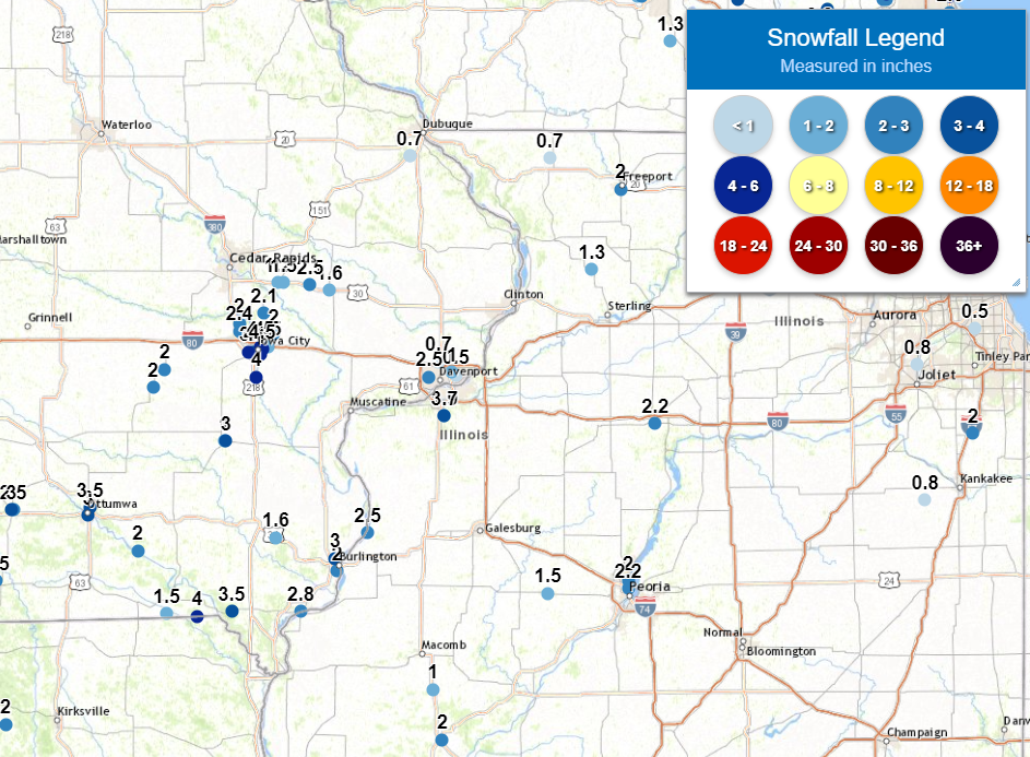
Official National Weather Service Observations Moline: 3.7" Davenport: 0.7" Dubuque: 0.7" ***Cedar Rapids, Iowa City and Burlington do not measure snow as part of their climate records. Please see the Snowfall Amounts and Storm Reports sections for reported snow amounts in these locations.*** |
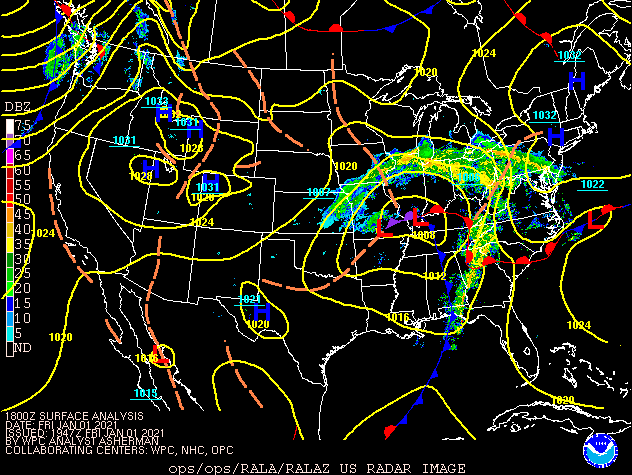 WPC - Surface Map and Radar |
Snowfall Amounts
 |
|
Storm Reports
PRELIMINARY LOCAL STORM REPORT...SUMMARY
NATIONAL WEATHER SERVICE QUAD CITIES IA IL
530 AM CST SAT JAN 2 2021
..TIME... ...EVENT... ...CITY LOCATION... ...LAT.LON...
..DATE... ....MAG.... ..COUNTY LOCATION..ST.. ...SOURCE....
..REMARKS..
1155 PM Snow 3 ENE Charlie Heath Mem 40.61N 91.84W
01/01/2021 M4.0 inch Clark MO Trained Spotter
Corrects previous snow report from 3 ENE
Charlie Heath Memorial. Storm total.
0910 AM Freezing Rain Little York 41.01N 90.74W
01/01/2021 E0.02 inch Warren IL Trained Spotter
Two hours of freezing rain and intermittent
power outages.
0925 PM Snow Freeport 42.28N 89.63W
01/01/2021 M2.0 inch Stephenson IL Trained Spotter
So far.
0350 PM Freezing Rain 2 WNW FREEPORT 42.30N 89.66W
01/01/2021 M0.20 inch Stephenson IL Trained Spotter
.
1200 AM Snow 4 SW Quad City Airport 41.40N 90.55W
01/02/2021 M3.7 inch Rock Island IL Official NWS Obs
Storm total snow and sleet.
0648 PM Freezing Rain 1 E COYNE CENTER 41.40N 90.55W
01/01/2021 M0.10 inch Rock Island IL Official NWS Obs
.
1031 AM Freezing Rain Putnam 41.18N 89.40W
01/01/2021 E0.15 inch Putnam IL Public
0746 PM Snow INDUSTRY 40.32N 90.61W
01/01/2021 M1.0 inch McDonough IL Trained Spotter
STORM TOTAL SNOW WITH 0.2 INCHES OF ICE.
0207 PM Freezing Rain 2 SE MACOMB 40.45N 90.65W
01/01/2021 M0.13 inch McDonough IL Public
.
1237 PM Freezing Rain 1 NW Macomb 40.48N 90.70W
01/01/2021 M0.30 inch McDonough IL Trained Spotter
Small to medium sized branches downed. Power
lines hanging low.
1057 AM Freezing Rain Prairie City 40.62N 90.47W
01/01/2021 E0.25 inch McDonough IL Trained Spotter
1004 AM Freezing Rain 1 W INDUSTRY 40.33N 90.64W
01/01/2021 E0.05 inch McDonough IL Trained Spotter
1/4 INCH ICE ON METAL SURFACES.
0918 AM Freezing Rain 1 ESE Macomb 40.46N 90.66W
01/01/2021 E0.20 inch McDonough IL Trained Spotter
Reports of medium-sized tree branches
snapped and some sagging power lines.
0500 PM Sleet 3 N STOCKTON 42.40N 90.00W
01/01/2021 M0.3 inch Jo Daviess IL CO-OP Observer
SLEET AND SNOW COMBINED IS 0.5 INCHES.
0351 PM Freezing Rain CAMBRIDGE 41.30N 90.20W
01/01/2021 M0.10 inch Henry IL Trained Spotter
.
0951 AM Sleet GENESEO 41.45N 90.15W
01/01/2021 M0.3 inch Henry IL NWS Employee
.
0950 AM Freezing Rain Geneseo 41.45N 90.15W
01/01/2021 E0.09 inch Henry IL NWS Employee
Just shy of a tenth of an inch.
1200 PM Freezing Rain Oquawka 40.94N 90.95W
01/01/2021 M0.20 inch Henderson IL Public
0157 PM Freezing Rain 3 E Carthage 40.42N 91.08W
01/01/2021 M0.10 inch Hancock IL Trained Spotter
Ice on trees and fences.
0906 AM Freezing Rain Augusta 40.23N 90.95W
01/01/2021 E0.20 inch Hancock IL CO-OP Observer
0.25 inches of ice and freezing rain.
0742 AM Freezing Rain 1 S CARTHAGE 40.40N 91.13W
01/01/2021 M0.02 inch Hancock IL Trained Spotter
TRACE OF ICE. CURRENTLY FREEZING RAIN AND
SLEET. 3/8 SLEET MEASURED.
0955 PM Snow Milledgeville 41.97N 89.78W
01/01/2021 M1.3 inch Carroll IL Trained Spotter
Storm total with about 0.10 inches of ice.
0400 PM Freezing Rain MILLEDGEVILLE 41.97N 89.78W
01/01/2021 M0.10 inch Carroll IL Trained Spotter
.
1027 AM Freezing Rain 1 SW Mount Carroll 42.09N 89.99W
01/01/2021 M0.20 inch Carroll IL Public
Freezing rain accumulation. Sleet was also
observed.
0800 PM Snow Washington 41.30N 91.69W
01/01/2021 M3.0 inch Washington IA Public
Storm total snow and sleet.
0549 PM Snow 1 W Washington 41.30N 91.70W
01/01/2021 M1.0 inch Washington IA Trained Spotter
Combination of snow and sleet. Currently
alternating between freezing rain and rain.
0600 PM Snow SELMA 40.87N 92.15W
01/01/2021 M2.0 inch Van Buren IA Trained Spotter
STORM TOTAL COMBINATION OF SNOW AND SLEET.
1200 AM Snow Davenport Airport 41.61N 90.58W
01/02/2021 M0.7 inch Scott IA Official NWS Obs
Storm total snow and sleet.
0800 PM Snow 1 WSW Davenport 41.55N 90.63W
01/01/2021 M2.5 inch Scott IA Public
Storm total of snow and sleet. Picture on
social media.
0700 PM Freezing Rain 2 ENE DAVENPORT 41.57N 90.57W
01/01/2021 M0.25 inch Scott IA NWS Employee
.
0656 PM Snow 1 W Bettendorf 41.56N 90.49W
01/01/2021 M0.5 inch Scott IA Trained Spotter
So far.
0433 PM Freezing Rain 1 W BETTENDORF 41.56N 90.49W
01/01/2021 E0.25 inch Scott IA Trained Spotter
GAVE AN ESTIMATED RANGE BETWEEN 1/8 AND 1/4
INCH.
0800 PM Freezing Rain 3 NNW Muscatine 41.45N 91.08W
01/01/2021 M0.30 inch Muscatine IA Public
Also had 1.2 inches of snow and sleet.
0601 AM Freezing Rain 2 SE Muscatine 41.40N 91.06W
01/01/2021 M0.25 inch Muscatine IA Public
Measured on top of a vehicle.
0900 PM Snow 1 W Elmira 41.72N 91.44W
01/01/2021 M2.0 inch Johnson IA Trained Spotter
Storm total.
0800 PM Snow 2 SSE Hills 41.55N 91.53W
01/01/2021 E4.0 inch Johnson IA Public
Storm total.
0745 PM Snow Solon 41.80N 91.49W
01/01/2021 M2.1 inch Johnson IA Trained Spotter
Storm total.
0700 PM Snow 2 E Iowa City 41.66N 91.50W
01/01/2021 E4.5 inch Johnson IA Public
Storm total.
0700 PM Snow 2 ENE Iowa City 41.67N 91.51W
01/01/2021 M4.5 inch Johnson IA Public
Storm total.
1119 AM Freezing Rain 4 ENE Iowa City 41.67N 91.47W
01/01/2021 E0.01 inch Johnson IA Trained Spotter
ice pellets and slick sidewalks.
0910 PM Snow 1 WSW New London 40.92N 91.43W
01/01/2021 M1.6 inch Henry IA Trained Spotter
Storm total with just under 0.10 inches of
ice.
1200 AM Snow 1 NW Dubuque Airport 42.41N 90.73W
01/02/2021 M0.7 inch Dubuque IA Official NWS Obs
Storm total snow and sleet.
0742 PM Snow MECHANICSVILLE 41.91N 91.25W
01/01/2021 E2.5 inch Cedar IA Public
STORM TOTAL SNOW.
&&
 |
Media use of NWS Web News Stories is encouraged! Please acknowledge the NWS as the source of any news information accessed from this site. |
|