Wildfire smoke continues to impact air quality from the Great Lakes region into New England and the Mid-Atlantic today with widespread Air Quality Alerts in effect. Severe thunderstorms are expected across portions of the Ohio Valley and Lower Great Lakes into the Mid-Atlantic and Northeast, this afternoon into the evening. Monsoonal thunderstorms may bring areas of flooding to the Southwest. Read More >
Overview
|
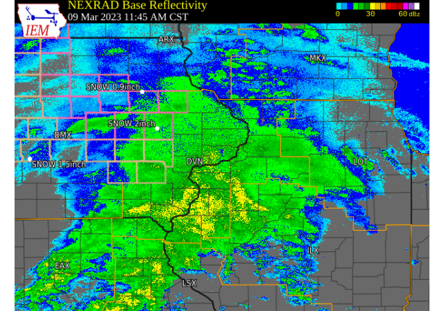
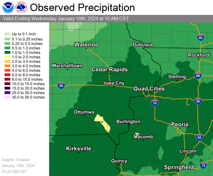
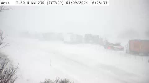
A strong winter storm brought heavy wet snow and gusty north winds to eastern IA, northwest IL, and northeast MO on Tuesday. Snowfall amounts between 6 and 10 inches were common, with higher totals of 11 to 15 inches falling mainly in Dubuque, Jones, Linn, and Johnson counties in Iowa. Several accidents occurred on area roads, with a long backup/delay observed on I-80 Tuesday evening near Iowa City. In addition, strong north winds over 30 mph were common with this storm. NWS Official Totals Dubuque: 12.6" |
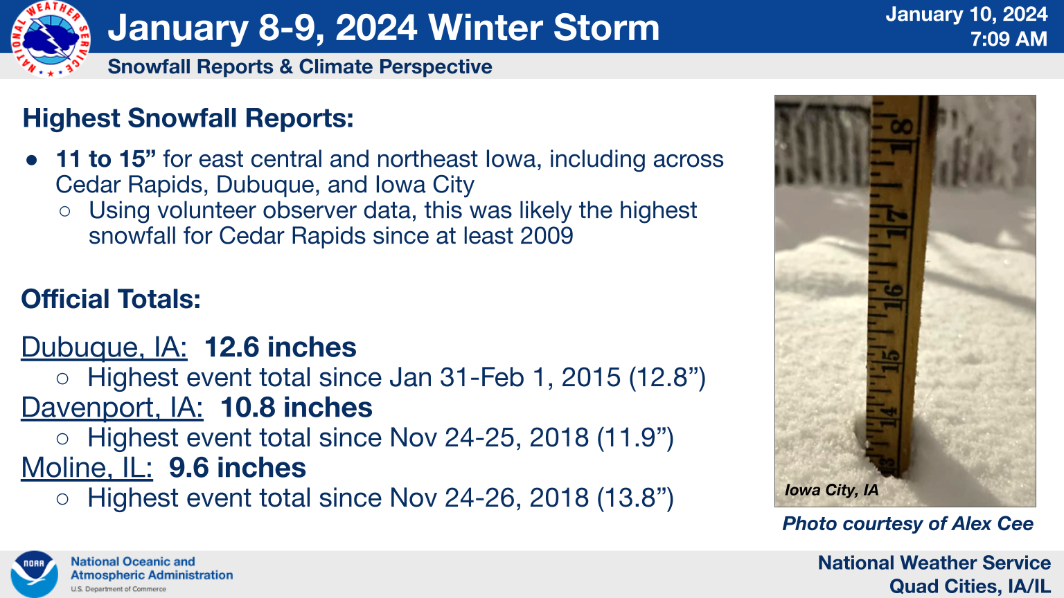 Snowfall Numbers and Climate Perspective from January 8-9 Event |
Snow
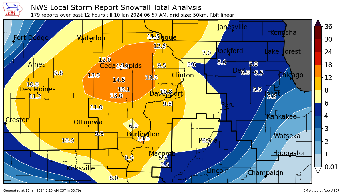
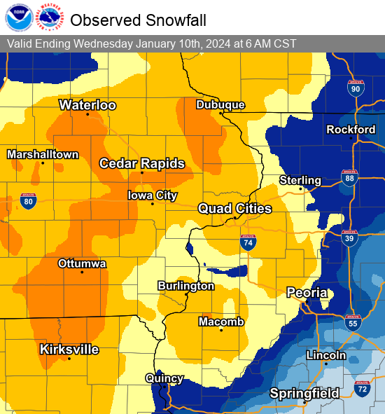
Snowfall Maps
| Midwest Snowfall Analysis Courtesy Iowa Environmental Mesonet |
Local Snowfall Analysis Courtesy Iowa Environmental Mesonet |
48-hr Local Snowfall Map |
.png) |
 |
 |
| 48-hr Local Precipitation Map Ending 6 AM Tuesday |
||
 |
Photos
 |
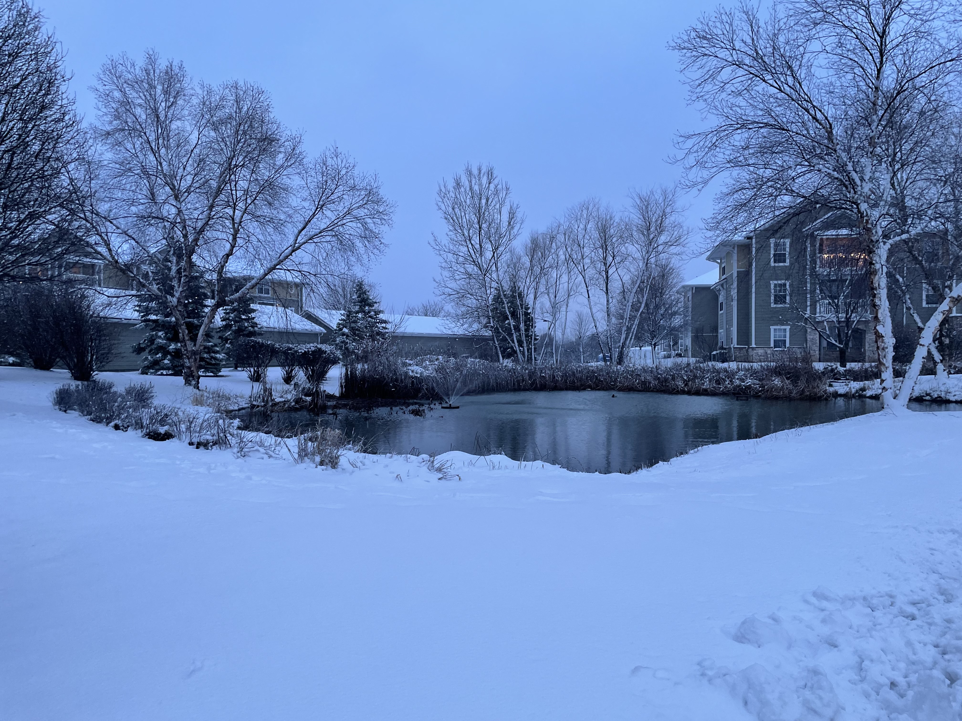 |
||
| Tiffin, IA (IA-DOT) |
Davenport, IA (David Cousins) |
Storm Reports
Storm Reports
Storm Reports Map - Courtesy IEM
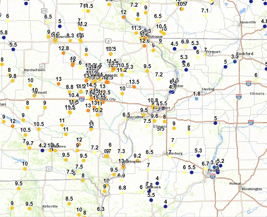 |
Preliminary Local Storm Report...Summary National Weather Service Quad Cities IA IL 1010 AM CST Wed Jan 10 2024 ..TIME... ...EVENT... ...CITY LOCATION... ...LAT.LON... ..DATE... ....MAG.... ..COUNTY LOCATION..ST.. ...SOURCE.... ..REMARKS.. 0830 PM Snow 1 SW University Heights 41.65N 91.57W 01/09/2024 M15.1 inch Johnson IA Trained Spotter 0515 PM Snow North Liberty 41.74N 91.61W 01/09/2024 M15.0 inch Johnson IA Trained Spotter Updated total so far. Still snowing hard. 0700 PM Snow 3 ENE Iowa City 41.68N 91.49W 01/09/2024 M15.0 inch Johnson IA Trained Spotter Storm total snow so far. 0800 PM Snow 2 NNW Marion 42.06N 91.61W 01/09/2024 M14.9 inch Linn IA Trained Spotter total. 0809 PM Snow 1 WNW Cou Falls 41.82N 91.69W 01/09/2024 M14.5 inch Johnson IA Trained Spotter total. 0549 PM Snow 3 E Iowa City 41.66N 91.48W 01/09/2024 M14.0 inch Johnson IA Public 0927 PM Snow Tiffin 41.71N 91.68W 01/09/2024 M14.0 inch Johnson IA Public Storm total snow. 0455 PM Snow 2 E Hiawatha 42.04N 91.64W 01/09/2024 E13.5 inch Linn IA Public 0822 PM Snow Anamosa 42.11N 91.29W 01/09/2024 M13.5 inch Jones IA Trained Spotter total. 0830 PM Snow 1 ENE Burlington Region 40.79N 91.11W 01/09/2024 M13.5 inch Des Moines IA Trained Spotter 0900 PM Snow Lowden 41.86N 90.92W 01/09/2024 M13.5 inch Cedar IA CO-OP Observer Updates previous snow report from Lowden. Very lightly snowing at time of observation. 1.41 inches of liquid water equivalent. 0843 AM Snow 1 W Elmira 41.72N 91.44W 01/10/2024 M13.5 inch Johnson IA Trained Spotter Storm total final. 0830 PM Snow 2 SSW Midway 42.08N 91.71W 01/09/2024 M13.2 inch Linn IA Trained Spotter total. 0515 PM Snow 1 NNE Fairfax 41.94N 91.78W 01/09/2024 M13.0 inch Linn IA Trained Spotter Updated total so far. Still snowing hard. 0630 PM Snow 2 NE Sharon Center 41.58N 91.64W 01/09/2024 M13.0 inch Johnson IA Public Storm total snow so far. 0845 PM Snow Solon 41.80N 91.49W 01/09/2024 M13.0 inch Johnson IA Trained Spotter Storm total snowfall. 0900 PM Snow 2 SSW Williamstown 41.54N 91.75W 01/09/2024 M13.0 inch Johnson IA Trained Spotter total. 0900 PM Snow Belle Plaine 41.90N 92.28W 01/09/2024 M13.0 inch Benton IA Trained Spotter Storm total snow. 0844 AM Snow 2 E Iowa City 41.66N 91.49W 01/10/2024 M13.0 inch Johnson IA Trained Spotter Storm total final. 0756 AM Snow Lisbon 41.92N 91.39W 01/10/2024 M12.7 inch Linn IA Trained Spotter Storm total event. 0600 AM Snow Dubuque Regional Arpt 42.41N 90.73W 01/10/2024 M12.6 inch Dubuque IA Official NWS Obs Storm total. 0953 PM Snow 1 SSW North Liberty 41.73N 91.62W 01/09/2024 M12.4 inch Johnson IA Trained Spotter Updates previous snow report from 1 SSW North Liberty. Storm total snow. 0609 PM Snow Mount Vernon 41.92N 91.42W 01/09/2024 M12.3 inch Linn IA Public 0450 PM Snow 1 SSW Vinton 42.15N 92.03W 01/09/2024 M12.0 inch Benton IA Trained Spotter Updates previous snow report from 1 SSW Vinton. Total snowfall so far. Still snowing at time of observation. 0521 PM Snow 1 SW Perlee 41.08N 91.91W 01/09/2024 M12.0 inch Jefferson IA Trained Spotter Updated total so far. Still snowing. 0540 PM Snow 1 ENE Mount Vernon 41.93N 91.41W 01/09/2024 M12.0 inch Linn IA Trained Spotter Updated total so far. Still snowing. 0700 PM Snow Coralville 41.69N 91.60W 01/09/2024 M12.0 inch Johnson IA Public Storm total snow so far. Still lightly snowing at time of observation. 0822 PM Snow 1 WNW Dubuque 42.51N 90.72W 01/09/2024 M12.0 inch Dubuque IA Trained Spotter 0859 PM Snow 1 ENE Vinton 42.17N 92.02W 01/09/2024 M12.0 inch Benton IA Public 0938 PM Snow 1 WSW Hiawatha 42.04N 91.70W 01/09/2024 M12.0 inch Linn IA Trained Spotter 0500 AM Snow 3 NNE Cedar Rapids 42.01N 91.66W 01/10/2024 M11.6 inch Linn IA Trained Spotter 0300 PM Snow 1 WNW Cedar Rapids 41.98N 91.69W 01/09/2024 M11.5 inch Linn IA Trained Spotter So far. Still snowing. 0430 PM Snow 4 NNW Ely 41.93N 91.62W 01/09/2024 E11.5 inch Linn IA Public Updated total so far. Still snowing. 0515 PM Snow 2 NNE Stone City 42.14N 91.33W 01/09/2024 M11.5 inch Jones IA Trained Spotter Updated total so far. Still snowing. 0550 PM Snow 3 N Marion 42.08N 91.59W 01/09/2024 M11.5 inch Linn IA Trained Spotter Total so far. Still snowing. 0800 PM Snow North English 41.52N 92.08W 01/09/2024 M11.5 inch Iowa IA Public Storm total snow. 0813 PM Snow 2 NE Cedar Rapids 41.99N 91.65W 01/09/2024 M11.5 inch Linn IA Trained Spotter 0522 AM Snow Parnell 41.59N 92.01W 01/10/2024 M11.5 inch Iowa IA Public 0541 AM Snow Rickardsville 42.58N 90.88W 01/10/2024 M11.5 inch Dubuque IA Trained Spotter Storm Total. 0500 PM Snow 2 NW Cedar Rapids 41.99N 91.70W 01/09/2024 M11.4 inch Linn IA Public 0330 PM Snow 2 N Olin 42.02N 91.14W 01/09/2024 M11.2 inch Jones IA Public Total snowfall so far. Still snowing at time of observation. 0604 PM Snow 1 W Amana 41.80N 91.88W 01/09/2024 M11.2 inch Iowa IA Public 0400 PM Snow University Heights 41.66N 91.56W 01/09/2024 M11.0 inch Johnson IA Trained Spotter So far. Still snowing. 0435 PM Snow Bertram 41.96N 91.53W 01/09/2024 M11.0 inch Linn IA Trained Spotter 0440 PM Snow 4 WNW Ollie 41.22N 92.15W 01/09/2024 M11.0 inch Keokuk IA Public Total snow so far. Still snowing at time of observation with reduced visibilities. 0450 PM Snow 1 SE Coralville 41.68N 91.58W 01/09/2024 M11.0 inch Johnson IA Cocorahs Updates previous snow report from 1 SE Coralville. Storm total snow so far. 0601 PM Snow Washington 41.29N 91.69W 01/09/2024 M11.0 inch Washington IA Public 0640 PM Snow 2 NNE Hazleton 42.64N 91.89W 01/09/2024 M11.0 inch Buchanan IA CO-OP Observer Updates previous snow report from 2 NNE Hazleton. Storm total amount. 0700 PM Snow 3 E Cedar Rapids 41.97N 91.61W 01/09/2024 M11.0 inch Linn IA Trained Spotter Storm total snow so far. 0920 PM Snow 1 W Sigourney 41.34N 92.22W 01/09/2024 M11.0 inch Keokuk IA Trained Spotter Storm total snow. 0930 PM Snow Hills 41.57N 91.54W 01/09/2024 M11.0 inch Johnson IA Fire Dept/Rescue 1026 PM Snow 2 W Cedar Rapids 41.98N 91.71W 01/09/2024 M11.0 inch Linn IA Trained Spotter Storm total snow. 0600 AM Snow Davenport Airport 41.61N 90.58W 01/10/2024 M10.8 inch Scott IA Official NWS Obs Storm total. 0400 PM Snow 2 ESE Fairview 42.08N 91.30W 01/09/2024 M10.5 inch Jones IA CO-OP Observer Updated total so far. Still snowing. 0511 PM Snow 3 SSW Center Junction 42.08N 91.11W 01/09/2024 M10.5 inch Jones IA Trained Spotter So far. Still snowing. 0606 PM Snow 2 S Buck Creek 42.30N 91.34W 01/09/2024 M10.5 inch Delaware IA Public 0518 PM Snow 1 N Williamsburg 41.68N 92.01W 01/09/2024 M10.4 inch Iowa IA Trained Spotter Updated total so far. Still snowing. 0320 PM Snow 4 SSE Cedar Rapids 41.92N 91.65W 01/09/2024 M10.3 inch Linn IA Trained Spotter 0343 PM Snow 2 ENE Hazleton 42.63N 91.86W 01/09/2024 M10.2 inch Buchanan IA CO-OP Observer Updated total so far. Still snowing. 0520 PM Snow 2 S Hiawatha 42.02N 91.69W 01/09/2024 M10.2 inch Linn IA Public 0800 PM Snow Riverside 41.48N 91.58W 01/09/2024 M10.2 inch Washington IA Trained Spotter total. 0915 PM Snow 2 WNW Marion 42.05N 91.63W 01/09/2024 M10.2 inch Linn IA Trained Spotter 0350 PM Snow Tipton 41.77N 91.13W 01/09/2024 E10.0 inch Cedar IA Public Delayed report. Still snowing. 0428 PM Snow 1 SSW Montrose 40.52N 91.42W 01/09/2024 M10.0 inch Lee IA Public So far. Still snowing. 0616 PM Snow 1 NNE Oakdale 41.71N 91.59W 01/09/2024 M10.0 inch Johnson IA Trained Spotter 0810 PM Snow 2 NW Marion 42.05N 91.61W 01/09/2024 M10.0 inch Linn IA Trained Spotter snow ended. 0700 AM Snow 1 WSW Memphis 40.46N 92.18W 01/10/2024 M10.0 inch Scotland MO CO-OP Observer storm total. 0820 AM Snow 1 NNE Marion 42.05N 91.58W 01/10/2024 M10.0 inch Linn IA Trained Spotter Storm total event. 0600 AM Snow Quad City Airport 41.40N 90.55W 01/10/2024 M9.6 inch Rock Island IL Official NWS Obs Storm total. 1120 AM Snow 3 E Fort Madison Munici 40.67N 91.28W 01/09/2024 M9.5 inch Lee IA Public Via social media. Still snowing. 0119 PM Snow Amana 41.80N 91.88W 01/09/2024 M9.5 inch Iowa IA Trained Spotter 0425 PM Snow Stockport 40.86N 91.83W 01/09/2024 E9.5 inch Van Buren IA Public Updated total so far. Still snowing. 0715 PM Snow Selma 40.87N 92.15W 01/09/2024 M9.5 inch Van Buren IA Trained Spotter Storm total snow. 0816 PM Snow 3 NE Cedar Rapids 42.00N 91.64W 01/09/2024 M9.5 inch Linn IA Trained Spotter 0946 PM Snow 1 NW Maquoketa 42.07N 90.68W 01/09/2024 M9.5 inch Jackson IA Trained Spotter Storm total snow. 1006 PM Snow 2 NW Buffalo 41.48N 90.74W 01/09/2024 E9.5 inch Scott IA Trained Spotter Event total. 0740 PM Snow 1 SSE Edmore 42.54N 90.68W 01/09/2024 M9.3 inch Dubuque IA Trained Spotter Updates previous snow report from 1 SSE Edmore. Still very lightly snowing at time of observation. 0941 AM Snow 1 SSE Manchester 42.47N 91.45W 01/10/2024 M9.3 inch Delaware IA CO-OP Observer storm total. 0947 PM Snow Biggsville 40.86N 90.86W 01/09/2024 M9.2 inch Henderson IL Public 0341 PM Snow Lore 42.51N 90.79W 01/09/2024 M9.0 inch Dubuque IA Trained Spotter 0430 PM Snow Cambridge 41.30N 90.20W 01/09/2024 M9.0 inch Henry IL Trained Spotter Updated total so far. Still snowing with some blowing now. 0445 PM Snow 1 ESE Independence 42.47N 91.88W 01/09/2024 M9.0 inch Buchanan IA Trained Spotter Updated total so far. Still snowing. 0505 PM Snow 1 E Fairfield 41.00N 91.94W 01/09/2024 M9.0 inch Jefferson IA Trained Spotter Updated total so far. Sill snowing. 0700 PM Snow 2 NNW North Liberty 41.76N 91.62W 01/09/2024 M9.0 inch Johnson IA Trained Spotter Updates previous snow report from 2 NNW North Liberty. Storm total snow so far. 0740 PM Snow 2 NE Davenport 41.58N 90.58W 01/09/2024 M9.0 inch Scott IA Trained Spotter Storm total snow so far. 0745 PM Snow 1 SSW Mooar 40.44N 91.45W 01/09/2024 M9.0 inch Lee IA Trained Spotter Updates previous snow report from 1 SSW Mooar. Storm total snow so far. Relayed via social media. 0815 PM Snow 1 S Iowa City 41.65N 91.53W 01/09/2024 M9.0 inch Johnson IA Emergency Mngr Storm total amount. 0928 PM Snow Walker 42.29N 91.78W 01/09/2024 M9.0 inch Linn IA Public 0959 PM Snow New London 40.92N 91.40W 01/09/2024 M9.0 inch Henry IA Public 0215 AM Snow Hiawatha 42.05N 91.68W 01/10/2024 M9.0 inch Linn IA Trained Spotter 0725 AM Snow 1 SSW Coal Valley 41.43N 90.45W 01/10/2024 M9.0 inch Rock Island IL Trained Spotter Storm total event. 0807 AM Snow 2 S Coggon 42.25N 91.54W 01/10/2024 E9.0 inch Linn IA Trained Spotter Storm total final. 0836 AM Snow 2 SW Saint Donatus 42.35N 90.57W 01/10/2024 M9.0 inch Jackson IA Trained Spotter Storm total snowfall. Snow is very slushy and estimates potentially a lost inch of snow depth due to compaction. 0300 PM Snow 1 SW Marengo 41.79N 92.08W 01/09/2024 M8.8 inch Iowa IA Trained Spotter So far. Still snowing. 0102 PM Snow 1 ENE Anamosa 42.11N 91.27W 01/09/2024 M8.7 inch Jones IA Trained Spotter 0250 PM Snow Oakdale 41.70N 91.59W 01/09/2024 M8.5 inch Johnson IA Public 0330 PM Snow 2 WNW Dubuque 42.52N 90.72W 01/09/2024 M8.5 inch Dubuque IA Trained Spotter Updated total so far. Still snowing. Visibility very poor. 0750 PM Snow 1 NW Center Grove 42.49N 90.73W 01/09/2024 M8.4 inch Dubuque IA Trained Spotter Storm total snow so far. 0345 PM Snow Jesup 42.48N 92.07W 01/09/2024 M8.3 inch Buchanan IA Trained Spotter So far. Still snowing. 0136 PM Snow 1 N Independence 42.49N 91.89W 01/09/2024 M8.0 inch Buchanan IA Trained Spotter So far. Still snowing. 0200 PM Snow 2 SW Tiffin 41.69N 91.70W 01/09/2024 M8.0 inch Johnson IA Trained Spotter Total so far. Still snowing. 0230 PM Snow 2 SSE Burlington Region 40.76N 91.11W 01/09/2024 M8.0 inch Des Moines IA Trained Spotter so far. 0300 PM Snow 1 WSW New London 40.92N 91.43W 01/09/2024 M8.0 inch Henry IA Trained Spotter Updated total so far. Still snowing. 0548 PM Snow 3 ENE Charlie Heath Mem 40.59N 91.84W 01/09/2024 M8.0 inch Clark MO Trained Spotter Updated total so far. Still snowing. 0600 PM Snow 4 N Fairfax 41.98N 91.77W 01/09/2024 M8.0 inch Linn IA Public 0940 PM Snow 2 SSE Warner 41.39N 90.37W 01/09/2024 E8.0 inch Henry IL Trained Spotter 0700 AM Snow Donnellson 40.65N 91.56W 01/10/2024 M7.9 inch Lee IA CO-OP Observer storm total. 0600 AM Snow 2 NE Clinton 41.86N 90.21W 01/10/2024 M7.7 inch Clinton IA Trained Spotter Storm total final. 1015 AM Snow Cantril 40.64N 92.07W 01/09/2024 M7.5 inch Van Buren IA Trained Spotter Updated total. Still snowing. 1147 AM Snow Reynolds 41.33N 90.68W 01/09/2024 M7.5 inch Rock Island IL Trained Spotter So far. Still snowing. 0120 PM Snow 3 SE Keosauqua 40.71N 91.91W 01/09/2024 M7.5 inch Van Buren IA Public 0130 PM Snow 3 WNW Tiffin 41.72N 91.73W 01/09/2024 M7.5 inch Johnson IA Trained Spotter So far. Still snowing. 1245 PM Snow 2 S Sperry 40.92N 91.15W 01/09/2024 E7.3 inch Des Moines IA Public Updated total from 2 S Sperry. So far. Still snowing. 0342 PM Snow Charlotte 41.96N 90.47W 01/09/2024 M7.2 inch Clinton IA Trained Spotter 0810 PM Snow 2 NNW Oakland Mills 40.97N 91.63W 01/09/2024 M7.2 inch Henry IA Trained Spotter Updates previous snow report from 2 NNW Oakland Mills. Still very lightly snowing at time of observation. 1250 PM Snow 3 ESE Hiawatha 42.03N 91.64W 01/09/2024 M7.0 inch Linn IA Broadcast Media 0215 PM Snow Kewanee 41.24N 89.93W 01/09/2024 M7.0 inch Henry IL Broadcast Media Storm total snow so far. 0400 PM Snow Roseville 40.73N 90.66W 01/09/2024 M7.0 inch Warren IL Public 0422 PM Snow 1 WNW Bettendorf 41.57N 90.50W 01/09/2024 M7.0 inch Scott IA Trained Spotter So far. Still snowing. 0445 PM Snow 1 NNE Dubuque 42.51N 90.68W 01/09/2024 M7.0 inch Dubuque IA Trained Spotter Updated total so far. Still snowing. 0609 PM Snow 2 NE New Windsor 41.23N 90.44W 01/09/2024 M7.0 inch Mercer IL Public 1100 PM Snow Freeport 42.29N 89.63W 01/09/2024 M7.0 inch Stephenson IL Trained Spotter 0222 AM Snow Macomb 40.47N 90.68W 01/10/2024 M7.0 inch McDonough IL Public 0940 AM Snow 1 SSW Kewanee 41.23N 89.93W 01/10/2024 M7.0 inch Henry IL Trained Spotter Storm Total. 0942 AM Snow Columbus Junction 41.28N 91.36W 01/10/2024 M7.0 inch Louisa IA CO-OP Observer storm total. 0730 PM Snow 2 NNE Colusa 40.59N 91.15W 01/09/2024 M6.9 inch Hancock IL Trained Spotter 0854 AM Snow 3 N Stockton 42.40N 90.00W 01/10/2024 M6.9 inch Jo Daviess IL CO-OP Observer Storm total final. 1205 PM Snow 1 NNE Carthage 40.42N 91.13W 01/09/2024 M6.8 inch Hancock IL Trained Spotter 0441 PM Snow 1 ENE Muscatine 41.42N 91.06W 01/09/2024 M6.5 inch Muscatine IA Trained Spotter So far. Still snowing. 0454 PM Snow Monmouth 40.91N 90.64W 01/09/2024 M6.5 inch Warren IL Public So far. Still snowing. Considerable compacting occurring. 1245 PM Snow Wyoming 42.06N 91.00W 01/09/2024 M6.3 inch Jones IA Trained Spotter Updated total so far. Still snowing. 0620 PM Snow 3 NNE Stockton 42.40N 89.99W 01/09/2024 M6.3 inch Jo Daviess IL Cocorahs Updates previous snow report from 3 NNE Stockton. Snow melted down to 0.53. Still snowing with three quarter mile visibility. 1047 AM Snow 3 W Mount Sterling 40.62N 92.00W 01/09/2024 M6.0 inch Van Buren IA Trained Spotter 1125 AM Snow 2 NNW Shellsburg 42.12N 91.89W 01/09/2024 M6.0 inch Benton IA Trained Spotter So far. Drifts up to a foot. Still snowing. 0358 PM Snow 1 WNW Galena 42.42N 90.44W 01/09/2024 M6.0 inch Jo Daviess IL Public 0549 PM Snow 2 W Bolton 42.26N 89.77W 01/09/2024 M6.0 inch Stephenson IL Public 0624 AM Snow 2 SW Yarmouth 41.01N 91.35W 01/10/2024 M6.0 inch Des Moines IA Trained Spotter 0736 AM Snow 2 WNW Freeport 42.30N 89.66W 01/10/2024 M5.8 inch Stephenson IL Trained Spotter Storm total event. 0943 AM Snow 1 NNE Aledo 41.21N 90.74W 01/10/2024 M5.8 inch Mercer IL CO-OP Observer storm total, heavy wet snow. likely some melting and compaction. 1010 AM Snow 1 ESE New London 40.92N 91.40W 01/09/2024 M5.7 inch Henry IA Trained Spotter 0845 PM Snow Mount Carroll 42.09N 89.98W 01/09/2024 M5.6 inch Carroll IL Public daily total. 1201 PM Snow 2 NNE New Windsor 41.23N 90.44W 01/09/2024 M5.5 inch Mercer IL Trained Spotter 0200 PM Snow 1 NE Hampton 41.57N 90.39W 01/09/2024 E5.5 inch Rock Island IL Trained Spotter So far. Still snowing. 0735 PM Snow 3 SE Macomb 40.44N 90.65W 01/09/2024 M5.5 inch McDonough IL Trained Spotter 0810 PM Snow Industry 40.32N 90.61W 01/09/2024 M5.5 inch McDonough IL Trained Spotter total so far. 0458 PM Snow Lena 42.38N 89.82W 01/09/2024 E5.3 inch Stephenson IL Public 0525 PM Snow 6 S Elmoville 42.19N 90.02W 01/09/2024 M5.3 inch Carroll IL Public 0752 PM Snow 2 ESE Macomb 40.46N 90.65W 01/09/2024 M5.3 inch McDonough IL Trained Spotter 0255 PM Snow 1 SE Princeton 41.37N 89.45W 01/09/2024 M5.0 inch Bureau IL CO-OP Observer so far. received another inch since 7 AM report. still snowing. 0525 PM Snow Albany 41.79N 90.22W 01/09/2024 M4.8 inch Whiteside IL Public Via social media. Compaction occurring. 1230 PM Snow 4 NE Clinton 41.88N 90.18W 01/09/2024 M4.5 inch Clinton IA Trained Spotter 0300 PM Snow 2 WNW Woodbine 42.37N 90.19W 01/09/2024 M4.5 inch Jo Daviess IL Trained Spotter 1218 PM Snow 1 NW Galena 42.43N 90.44W 01/09/2024 M4.0 inch Jo Daviess IL Trained Spotter 0315 PM Snow Bushnell 40.55N 90.50W 01/09/2024 E4.0 inch McDonough IL Public Current snow depth is 4 inches. Water equivalent for the storm so far is 1.11 inches. Considerable melting occurring with the snow. 0550 AM Snow Winslow 42.50N 89.79W 01/10/2024 M3.5 inch Stephenson IL Trained Spotter Storm total event. High probability of compaction occurring. SNOW REPORTS LISTED BY AMOUNT INCHES LOCATION ST COUNTY TIME ------ ----------------------- -- -------------- ------- 15.1 1 SW University Heights IA Johnson 0830 PM 15.0 3 ENE Iowa City IA Johnson 0700 PM 15.0 North Liberty IA Johnson 0515 PM 14.9 2 NNW Marion IA Linn 0800 PM 14.5 1 WNW Cou Falls IA Johnson 0809 PM 14.0 Tiffin IA Johnson 0927 PM 14.0 3 E Iowa City IA Johnson 0549 PM 13.5 1 W Elmira IA Johnson 0843 AM 13.5 Lowden IA Cedar 0900 PM 13.5 1 ENE Burlington Region IA Des Moines 0830 PM 13.5 Anamosa IA Jones 0822 PM 13.5 2 E Hiawatha IA Linn 0455 PM 13.2 2 SSW Midway IA Linn 0830 PM 13.0 2 E Iowa City IA Johnson 0844 AM 13.0 Belle Plaine IA Benton 0900 PM 13.0 2 SSW Williamstown IA Johnson 0900 PM 13.0 Solon IA Johnson 0845 PM 13.0 2 NE Sharon Center IA Johnson 0630 PM 13.0 1 NNE Fairfax IA Linn 0515 PM 12.7 Lisbon IA Linn 0756 AM 12.6 Dubuque Regional Arpt IA Dubuque 0600 AM 12.4 1 SSW North Liberty IA Johnson 0953 PM 12.3 Mount Vernon IA Linn 0609 PM 12.0 1 WSW Hiawatha IA Linn 0938 PM 12.0 1 ENE Vinton IA Benton 0859 PM 12.0 1 WNW Dubuque IA Dubuque 0822 PM 12.0 Coralville IA Johnson 0700 PM 12.0 1 ENE Mount Vernon IA Linn 0540 PM 12.0 1 SW Perlee IA Jefferson 0521 PM 12.0 1 SSW Vinton IA Benton 0450 PM 11.6 3 NNE Cedar Rapids IA Linn 0500 AM 11.5 Rickardsville IA Dubuque 0541 AM 11.5 Parnell IA Iowa 0522 AM 11.5 2 NE Cedar Rapids IA Linn 0813 PM 11.5 North English IA Iowa 0800 PM 11.5 3 N Marion IA Linn 0550 PM 11.5 2 NNE Stone City IA Jones 0515 PM 11.5 4 NNW Ely IA Linn 0430 PM 11.5 1 WNW Cedar Rapids IA Linn 0300 PM 11.4 2 NW Cedar Rapids IA Linn 0500 PM 11.2 1 W Amana IA Iowa 0604 PM 11.2 2 N Olin IA Jones 0330 PM 11.0 2 W Cedar Rapids IA Linn 1026 PM 11.0 Hills IA Johnson 0930 PM 11.0 1 W Sigourney IA Keokuk 0920 PM 11.0 3 E Cedar Rapids IA Linn 0700 PM 11.0 2 NNE Hazleton IA Buchanan 0640 PM 11.0 Washington IA Washington 0601 PM 11.0 1 SE Coralville IA Johnson 0450 PM 11.0 4 WNW Ollie IA Keokuk 0440 PM 11.0 Bertram IA Linn 0435 PM 11.0 University Heights IA Johnson 0400 PM 10.8 Davenport Airport IA Scott 0600 AM 10.5 2 S Buck Creek IA Delaware 0606 PM 10.5 3 SSW Center Junction IA Jones 0511 PM 10.5 2 ESE Fairview IA Jones 0400 PM 10.4 1 N Williamsburg IA Iowa 0518 PM 10.3 4 SSE Cedar Rapids IA Linn 0320 PM 10.2 2 WNW Marion IA Linn 0915 PM 10.2 Riverside IA Washington 0800 PM 10.2 2 S Hiawatha IA Linn 0520 PM 10.2 2 ENE Hazleton IA Buchanan 0343 PM 10.0 1 NNE Marion IA Linn 0820 AM 10.0 1 WSW Memphis MO Scotland 0700 AM 10.0 2 NW Marion IA Linn 0810 PM 10.0 1 NNE Oakdale IA Johnson 0616 PM 10.0 1 SSW Montrose IA Lee 0428 PM 10.0 Tipton IA Cedar 0350 PM 9.6 Quad City Airport IL Rock Island 0600 AM 9.5 2 NW Buffalo IA Scott 1006 PM 9.5 1 NW Maquoketa IA Jackson 0946 PM 9.5 3 NE Cedar Rapids IA Linn 0816 PM 9.5 Selma IA Van Buren 0715 PM 9.5 Stockport IA Van Buren 0425 PM 9.5 Amana IA Iowa 0119 PM 9.5 3 E Fort Madison Munici IA Lee 1120 AM 9.3 1 SSE Manchester IA Delaware 0941 AM 9.3 1 SSE Edmore IA Dubuque 0740 PM 9.2 Biggsville IL Henderson 0947 PM 9.0 2 SW Saint Donatus IA Jackson 0836 AM 9.0 2 S Coggon IA Linn 0807 AM 9.0 1 SSW Coal Valley IL Rock Island 0725 AM 9.0 Hiawatha IA Linn 0215 AM 9.0 New London IA Henry 0959 PM 9.0 Walker IA Linn 0928 PM 9.0 1 S Iowa City IA Johnson 0815 PM 9.0 1 SSW Mooar IA Lee 0745 PM 9.0 2 NE Davenport IA Scott 0740 PM 9.0 2 NNW North Liberty IA Johnson 0700 PM 9.0 1 E Fairfield IA Jefferson 0505 PM 9.0 1 ESE Independence IA Buchanan 0445 PM 9.0 Cambridge IL Henry 0430 PM 9.0 Lore IA Dubuque 0341 PM 8.8 1 SW Marengo IA Iowa 0300 PM 8.7 1 ENE Anamosa IA Jones 0102 PM 8.5 2 WNW Dubuque IA Dubuque 0330 PM 8.5 Oakdale IA Johnson 0250 PM 8.4 1 NW Center Grove IA Dubuque 0750 PM 8.3 Jesup IA Buchanan 0345 PM 8.0 2 SSE Warner IL Henry 0940 PM 8.0 4 N Fairfax IA Linn 0600 PM 8.0 3 ENE Charlie Heath Mem MO Clark 0548 PM 8.0 1 WSW New London IA Henry 0300 PM 8.0 2 SSE Burlington Region IA Des Moines 0230 PM 8.0 2 SW Tiffin IA Johnson 0200 PM 8.0 1 N Independence IA Buchanan 0136 PM 7.9 Donnellson IA Lee 0700 AM 7.7 2 NE Clinton IA Clinton 0600 AM 7.5 3 WNW Tiffin IA Johnson 0130 PM 7.5 3 SE Keosauqua IA Van Buren 0120 PM 7.5 Reynolds IL Rock Island 1147 AM 7.5 Cantril IA Van Buren 1015 AM 7.3 2 S Sperry IA Des Moines 1245 PM 7.2 2 NNW Oakland Mills IA Henry 0810 PM 7.2 Charlotte IA Clinton 0342 PM 7.0 Columbus Junction IA Louisa 0942 AM 7.0 1 SSW Kewanee IL Henry 0940 AM 7.0 Macomb IL Mcdonough 0222 AM 7.0 Freeport IL Stephenson 1100 PM 7.0 2 NE New Windsor IL Mercer 0609 PM 7.0 1 NNE Dubuque IA Dubuque 0445 PM 7.0 1 WNW Bettendorf IA Scott 0422 PM 7.0 Roseville IL Warren 0400 PM 7.0 Kewanee IL Henry 0215 PM 7.0 3 ESE Hiawatha IA Linn 1250 PM 6.9 3 N Stockton IL Jo Daviess 0854 AM 6.9 2 NNE Colusa IL Hancock 0730 PM 6.8 1 NNE Carthage IL Hancock 1205 PM 6.5 Monmouth IL Warren 0454 PM 6.5 1 ENE Muscatine IA Muscatine 0441 PM 6.3 3 NNE Stockton IL Jo Daviess 0620 PM 6.3 Wyoming IA Jones 1245 PM 6.0 2 SW Yarmouth IA Des Moines 0624 AM 6.0 2 W Bolton IL Stephenson 0549 PM 6.0 1 WNW Galena IL Jo Daviess 0358 PM 6.0 2 NNW Shellsburg IA Benton 1125 AM 6.0 3 W Mount Sterling IA Van Buren 1047 AM 5.8 1 NNE Aledo IL Mercer 0943 AM 5.8 2 WNW Freeport IL Stephenson 0736 AM 5.7 1 ESE New London IA Henry 1010 AM 5.6 Mount Carroll IL Carroll 0845 PM 5.5 Industry IL Mcdonough 0810 PM 5.5 3 SE Macomb IL Mcdonough 0735 PM 5.5 1 NE Hampton IL Rock Island 0200 PM 5.5 2 NNE New Windsor IL Mercer 1201 PM 5.3 2 ESE Macomb IL Mcdonough 0752 PM 5.3 6 S Elmoville IL Carroll 0525 PM 5.3 Lena IL Stephenson 0458 PM 5.0 1 SE Princeton IL Bureau 0255 PM 4.8 Albany IL Whiteside 0525 PM 4.5 2 WNW Woodbine IL Jo Daviess 0300 PM 4.5 4 NE Clinton IA Clinton 1230 PM 4.0 Bushnell IL Mcdonough 0315 PM 4.0 1 NW Galena IL Jo Daviess 1218 PM 3.5 Winslow IL Stephenson 0550 AM
Environment
 |
 |
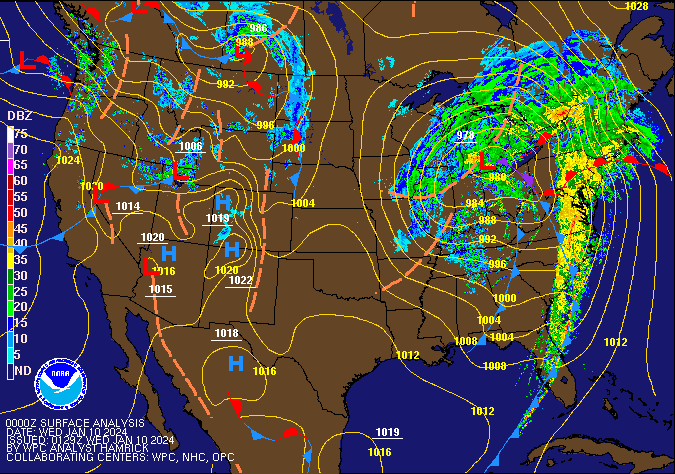 |
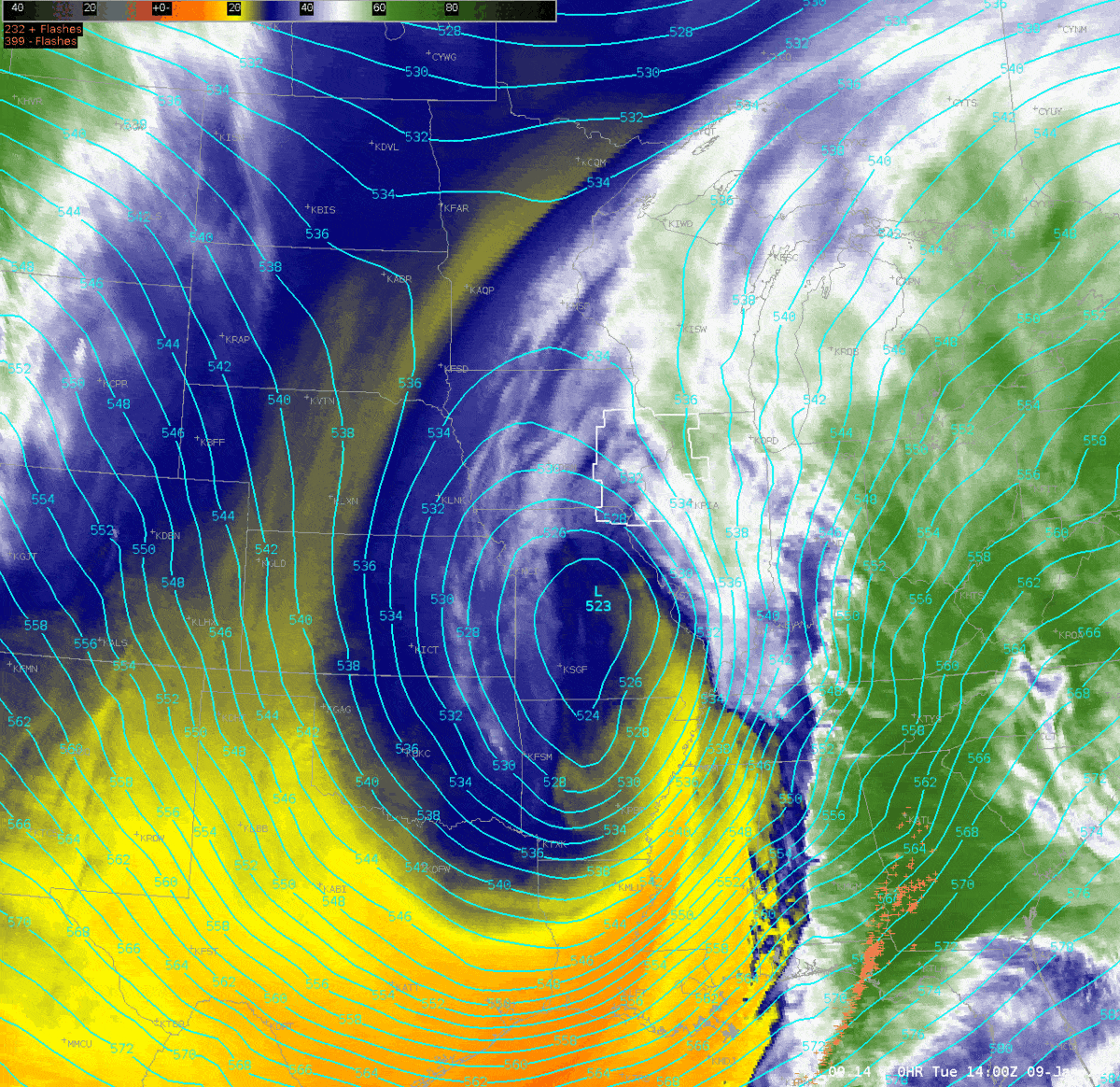
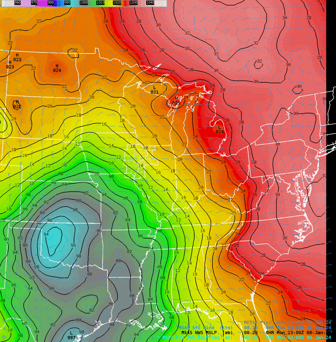
| Figure 1: Water Vapor Loop of Upper Low | Figure 2: MSLP from MSAS analysis | Figure 3: WPC Sea Level Pressure/Fronts/Radar Loop (9am Tue - 9pm Tue) |
 |
Media use of NWS Web News Stories is encouraged! Please acknowledge the NWS as the source of any news information accessed from this site. |
|