Overview
|
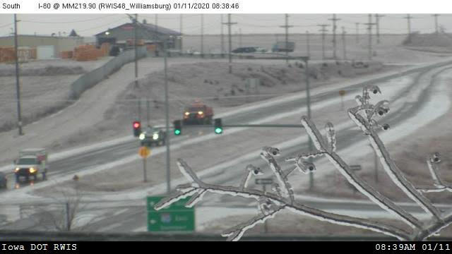
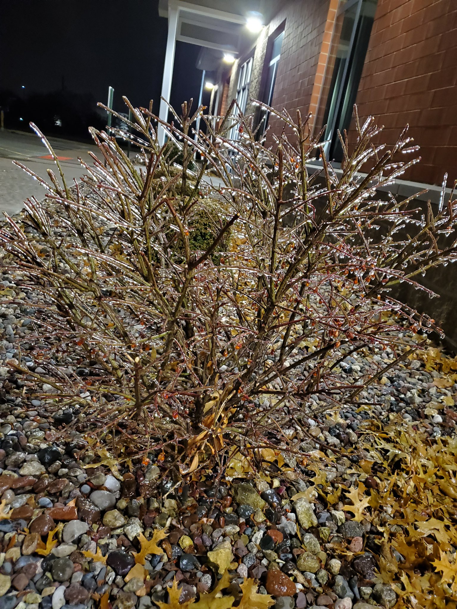
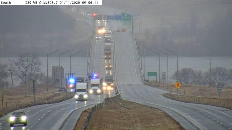
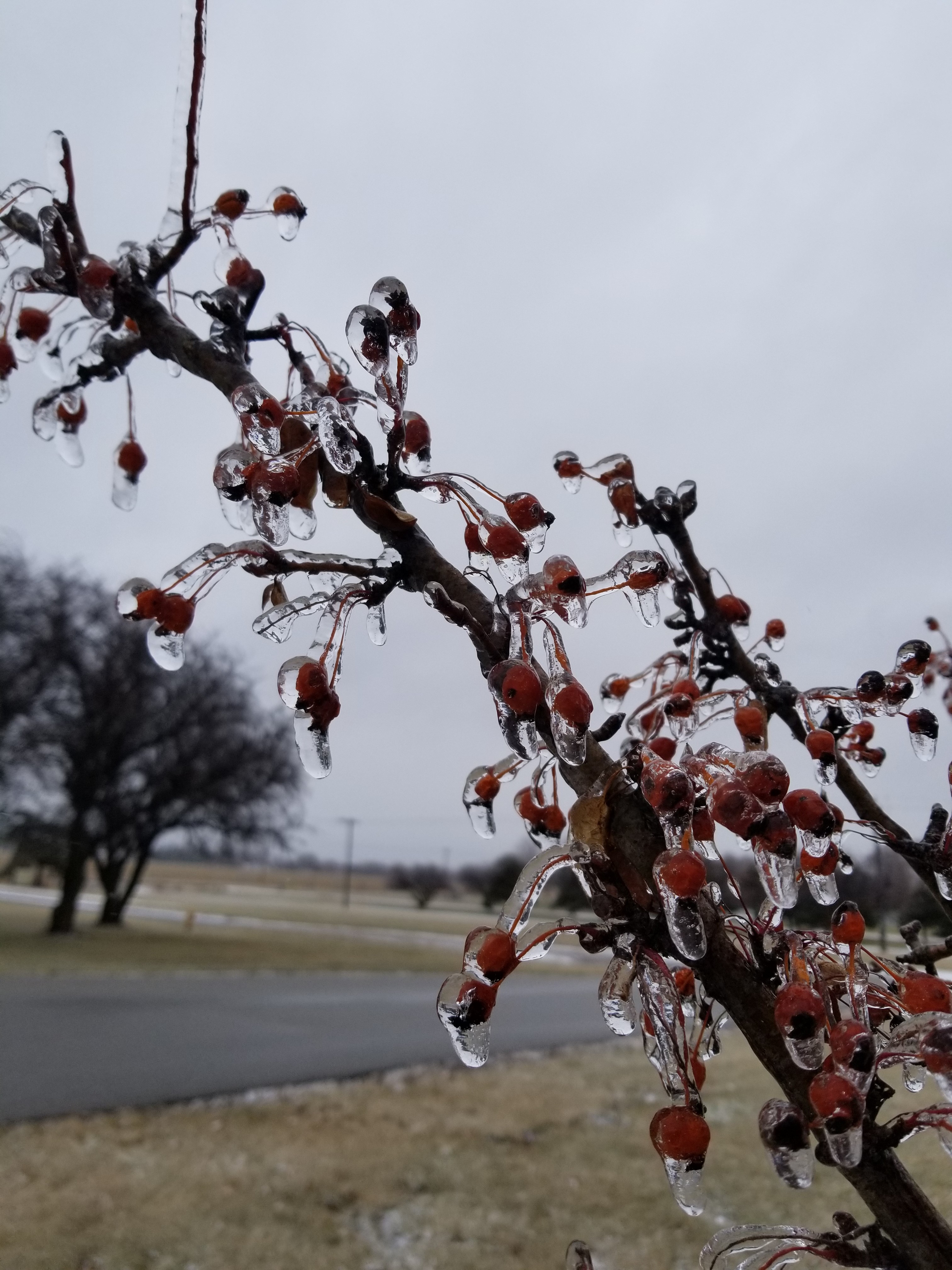
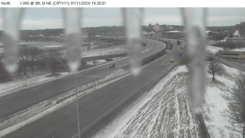
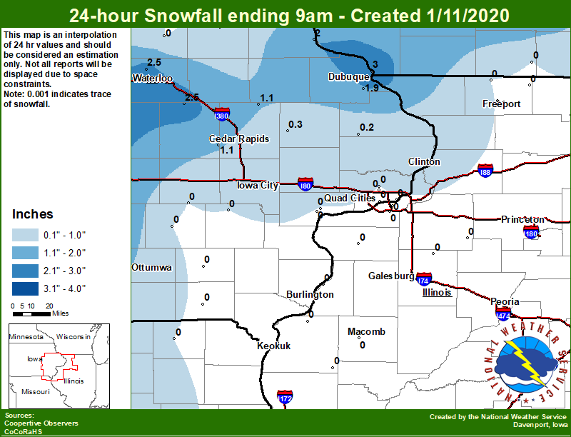
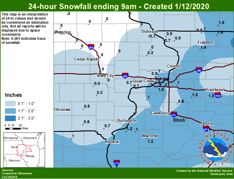
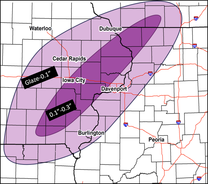
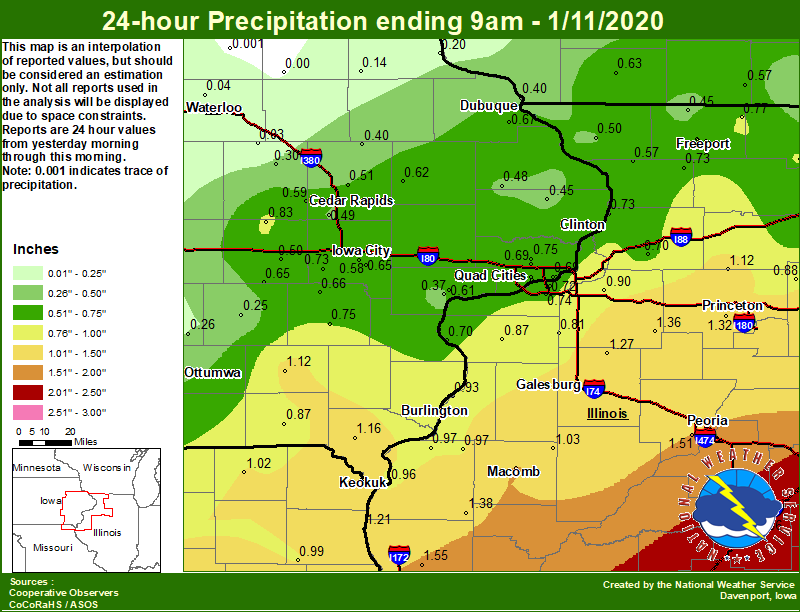
An strong winter storm system brought heavy rains of 1 to 2 inches to areas along and east of the Mississippi River Friday, Jan. 10 into Saturday, Jan. 11. Much of eastern Iowa and northwest Illinois saw a wintry mix of sleet, snow, freezing rain and freezing drizzle. Slick roads were common, with several accidents reported throughout the region. There were numerous reports of ice accumulations of a tenth inch to around a quarter inch. Some trees were downed from the weight of the ice and numerous power outages were reported. Snowfall amounts were generally between 1 and 3 inches that fell in 2 rounds. The first one Friday night-Saturday with snow falling across the northwest portions of forecast area and the second one over the southeast. |
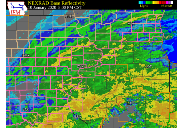
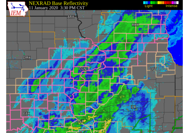
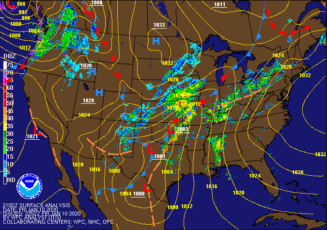 Surface / Radar Loop WPC |
||||||||||
|
|||||||||||
Snow/Ice
| Jump to: Ice graphic | |
| 1/10 to 1/11 Snowfall Map (1st Round) | 1/11 to 1/12 Snowfall Map (2nd Round) |
 |
 |
|
24 hour snow fall in inches, ....IOWA.... ....WISCONSIN.... |
24 hour snow fall in inches,
Reported between 6 AM and 9 AM,
Sunday January 12, 2020.

....IOWA....
Bettendorf 2.2 SE                 1.5
Davenport 0.9 SSW                 1.5
Allerton 2 S                      1.3
Davenport Arpt                    1.1
Park View 0.2 WSW                 1.0
Eldridge 0.7 SSW                  0.9
Davenport 0.9 WNW                 0.9
Keosauqua                         0.8
Muscatine 2N                      0.7
Bellevue LD12                     0.7
Donnellson                        0.7
Fairfield                         0.5
Washington                        0.3
Wellman 4.0 E                     0.3
Maquoketa                         0.2
Dubuque Arpt                      0.1
....ILLINOIS....
Rockford ASOS                     2.1
Minonk                            2.1
Mundelein                         2.0
Davis 0.5 N                       1.8
Moline 0.7 NNE                    1.7
Quad City Arpt                    1.6
Kewanee 1 E                       1.5
Tiskilwa 2.1 N                    1.5
Shannon 0.2 S                     1.4
Colchester 3.5 NE                 1.2
Dallas City 3.0 SSE               1.2
Aledo                             1.0
Ottawa 4 SW                       1.0
La Harpe                          1.0
Galesburg                         1.0
Gladstone LD18                    1.0
Freeport                          1.0
Tuscola                           1.0
Orangeville 2.8 NW                1.0
Coal Valley 1.9 SE                1.0
Geneseo 2.0 NW                    1.0
Freeport 1.7 NW                   1.0
Altona                            0.8
Paw Paw 1 E                       0.7
Ill. City LD16 3 WNW              0.7
Windsor                           0.5
Galena                            0.5
Elizabeth                         0.5
Winslow 4.3 ESE                   0.5
Freeport 2.9 WSW                  0.5
Princeton 1.1 SE                  0.4
Princeton                         0.4
Ogden                             0.3
|
| Ice Estimates Friday Night-Saturday 1/10-1/11 | |
 |
Storm Reports
| Interactive Rain, Ice, and Snow Map |
 |
PRELIMINARY LOCAL STORM REPORT...SUMMARY
NATIONAL WEATHER SERVICE QUAD CITIES IA IL
936 AM CST SAT JAN 11 2020

..TIME...   ...EVENT...      ...CITY LOCATION...     ...LAT.LON...
..DATE...   ....MAG....      ..COUNTY LOCATION..ST.. ...SOURCE....
            ..REMARKS..

0920 AM     FREEZING RAIN    1 ESE WILLIAMSBURG      41.66N 92.00W
01/11/2020  E0.10 INCH       IOWA               IA   CO-OP OBSERVER


0915 AM     FREEZING RAIN    CAMBRIDGE               41.30N 90.20W
01/11/2020  U0.00 INCH       HENRY              IL   TRAINED SPOTTER

            LIGHT GLAZE OF ICE. REPORTED THAT THE POWER
            WAS OUT.

0910 AM     SNOW             3 NE CEDAR RAPIDS       42.01N 91.64W
01/11/2020  M1.6 INCH        LINN               IA   TRAINED SPOTTER


0906 AM     FREEZING RAIN    1 E WEST BURLINGTON     40.82N 91.16W
01/11/2020  E0.05 INCH       DES MOINES         IA   TRAINED SPOTTER

            ESTIMATED A DIME THICKNESS TO ACCUMULATED
            FREEZING RAIN. TRYING TO CHANGE OVER TO
            SNOW.

0904 AM     FREEZING RAIN    STANWOOD                41.89N 91.15W
01/11/2020  M0.20 INCH       CEDAR              IA   TRAINED SPOTTER

            ICE ON CLOTHES LINE, CURRENTLY HAVE NO
            POWER. OUTAGE OCCURRED AROUND 130 AM.

0846 AM     SNOW             4 W CEDAR RAPIDS        41.97N 91.75W
01/11/2020  M1.3 INCH        LINN               IA   BROADCAST MEDIA

            CORRECTS PREVIOUS LSR WHICH HAD FREEZING
            RAIN REPORT AND FROM 4 NNE FAIRFAX.

0838 AM     FREEZING RAIN    3 SSW PENROSE           41.85N 89.69W
01/11/2020  U0.00 INCH       WHITESIDE          IL   TRAINED SPOTTER

            GLAZE OF ICE ON ELEVATED SURFACES. ICE WAS
            ALSO ACCUMULATING ON ROADS.

0829 AM     FREEZING RAIN    1 NNE FAIRFIELD         41.02N 91.96W
01/11/2020  E0.25 INCH       JEFFERSON          IA   CO-OP OBSERVER

            GLAZE ON MOST SURFACES, POWER OUTAGE
            OVERNIGHT.

0815 AM     HEAVY RAIN       MACOMB MUNICIPAL ARPT   40.52N 90.65W
01/11/2020  M1.28 INCH       MCDONOUGH          IL   AWOS

            AWOS STATION KMQB MACOMB ARPT.

0804 AM     HEAVY RAIN       1 W LOMBARDVILLE        41.24N 89.66W
01/11/2020  M1.61 INCH       BUREAU             IL   TRAINED SPOTTER


0800 AM     FREEZING RAIN    CEDAR RAPIDS            41.97N 91.67W
01/11/2020  E0.20 INCH       LINN               IA   PUBLIC


0759 AM     FREEZING RAIN    MILLEDGEVILLE           41.97N 89.78W
01/11/2020  M0.25 INCH       CARROLL            IL   TRAINED SPOTTER


0730 AM     HEAVY RAIN       1 SSW BALD BLUFF        41.00N 90.85W
01/11/2020  M1.04 INCH       HENDERSON          IL   MESONET

            MESONET STATION OQUI2 HENDERSON RIVER.

0730 AM     FREEZING RAIN    3 SW WINNESHIEK         42.32N 89.57W
01/11/2020  E0.10 INCH       STEPHENSON         IL   TRAINED SPOTTER

            EVERYTHING IS COATED IN ABOUT AN 1/8 OF ICE.

0725 AM     FREEZING RAIN    2 N MUSCATINE           41.47N 91.05W
01/11/2020  U0.00 INCH       MUSCATINE          IA   CO-OP OBSERVER

            GLAZE OF ICE ON ELEVATED SURFACES.

0715 AM     HEAVY RAIN       1 NW NIOTA              40.63N 91.30W
01/11/2020  M1.27 INCH       HANCOCK            IL   MESONET

            MESONET STATION FMDI4 1.0 NW NIOTA.

0700 AM     HEAVY RAIN       PRINCETON               41.38N 89.46W
01/11/2020  M1.03 INCH       BUREAU             IL   CO-OP OBSERVER

            CO-OP OBSERVER STATION PTNI2 PRINCETON.

0700 AM     HEAVY RAIN       1 SE PRINCETON          41.37N 89.45W
01/11/2020  M1.03 INCH       BUREAU             IL   COCORAHS

            COCORAHS STATION IL-BU-5 PRINCETON 1.1 SE.

0700 AM     HEAVY RAIN       3 NW OHIO               41.58N 89.50W
01/11/2020  M1.12 INCH       BUREAU             IL   COCORAHS

            COCORAHS STATION IL-BU-11 WALNUT 5.3 ENE.

0700 AM     HEAVY RAIN       DONNELLSON              40.65N 91.56W
01/11/2020  M1.16 INCH       LEE                IA   CO-OP OBSERVER

            CO-OP OBSERVER STATION DNNI4 DONNELLSON.

0700 AM     HEAVY RAIN       2 N TISKILWA            41.32N 89.50W
01/11/2020  M1.32 INCH       BUREAU             IL   COCORAHS

            COCORAHS STATION IL-BU-8 TISKILWA 2.1 N.

0700 AM     HEAVY RAIN       1 E KEWANEE             41.24N 89.90W
01/11/2020  M1.36 INCH       HENRY              IL   CO-OP OBSERVER

            CO-OP OBSERVER STATION KEWI2 KEWANEE 1 E.

0700 AM     HEAVY RAIN       3 W MACOMB              40.46N 90.75W
01/11/2020  M1.40 INCH       MCDONOUGH          IL   COCORAHS

            COCORAHS STATION IL-MCD-7 COLCHESTER 3.5 NE.

0700 AM     HEAVY RAIN       1 NE MACOMB             40.48N 90.67W
01/11/2020  M1.55 INCH       MCDONOUGH          IL   CO-OP OBSERVER

            CO-OP OBSERVER STATION MQBI2 MACOMB.

0632 AM     HEAVY RAIN       CARTHAGE                40.41N 91.13W
01/11/2020  M1.00 INCH       HANCOCK            IL   TRAINED SPOTTER

            LIGHT FREEZING DRIZZLE CURRENTLY.

0631 AM     SNOW             2 NNE STONE CITY        42.14N 91.33W
01/11/2020  E1.0 INCH        JONES              IA   TRAINED SPOTTER


0631 AM     FREEZING RAIN    1 SSW NORTH LIBERTY     41.73N 91.62W
01/11/2020  E0.25 INCH       JOHNSON            IA   TRAINED SPOTTER

            ICE ON TREES.

0627 AM     SNOW             DUBUQUE REGIONAL ARPT   42.41N 90.73W
01/11/2020  M1.9 INCH        DUBUQUE            IA   OFFICIAL NWS OBS

            PAST 12 HRS.

0600 AM     HEAVY RAIN       2 SSW COLMAR            40.33N 90.90W
01/11/2020  M1.34 INCH       MCDONOUGH          IL   MESONET

            MESONET STATION CLMI2 LA MOINE RIVER.

0600 AM     HEAVY RAIN       1 WSW MEMPHIS           40.46N 92.18W
01/11/2020  M1.02 INCH       SCOTLAND           MO   CO-OP OBSERVER

            CO-OP OBSERVER STATION MMPM7 MEMPHIS.

0600 AM     HEAVY RAIN       2 S PRAIRIE CITY        40.59N 90.46W
01/11/2020  M1.03 INCH       MCDONOUGH          IL   CO-OP OBSERVER

            CO-OP OBSERVER STATION PRCI2 2.0 S PRAIRIE
            CITY.

0530 AM     HEAVY RAIN       AUGUSTA                 40.23N 90.95W
01/11/2020  M1.38 INCH       HANCOCK            IL   CO-OP OBSERVER

            CO-OP OBSERVER STATION AUGI2 AUGUSTA.

0514 AM     SNOW             CEDAR RAPIDS            41.98N 91.67W
01/11/2020  M1.9 INCH        LINN               IA   TRAINED SPOTTER


0510 AM     SNOW             MARION                  42.03N 91.60W
01/11/2020  M1.9 INCH        LINN               IA   BROADCAST MEDIA


0410 AM     FREEZING RAIN    DAVENPORT AIRPORT       41.61N 90.58W
01/11/2020  E0.10 INCH       SCOTT              IA   OFFICIAL NWS OBS


0247 AM     SNOW             HIAWATHA                42.04N 91.68W
01/11/2020  M1.9 INCH        LINN               IA   TRAINED SPOTTER


0111 AM     FREEZING RAIN    2 N FREEPORT            42.35N 89.63W
01/11/2020  M0.30 INCH       STEPHENSON         IL   TRAINED SPOTTER

            MEASURED ON SQUAD CAR ON ANTENNA. ELEVATED
            SURFACES COVERED IN ICE. TREE BRANCHES AND
            WIRES DOWN.

1230 AM     FREEZING RAIN    LOWDEN                  41.86N 90.93W
01/11/2020  E0.25 INCH       CEDAR              IA   CO-OP OBSERVER

            1/4 INCH ICE IN THE TREES. ROADS AND
            SIDEWALKS WERE JUST BEGINNING TO GET ICY.

1137 PM     SNOW             4 SE PALO               42.02N 91.77W
01/10/2020  M1.5 INCH        LINN               IA   BROADCAST MEDIA


1107 PM     FREEZING RAIN    CANTRIL                 40.65N 92.06W
01/10/2020  M0.13 INCH       VAN BUREN          IA   TRAINED SPOTTER

            1/8 INCH ICE STARTING TO COVER THE TREES.

1049 PM     FREEZING RAIN    MOUNT UNION             41.06N 91.39W
01/10/2020  E0.13 INCH       HENRY              IA   TRAINED SPOTTER

            1/8 INCH ICE COVERING TREES.

1043 PM     FREEZING RAIN    1 WNW MOUNT UNION       41.06N 91.40W
01/10/2020  E0.13 INCH       HENRY              IA   TRAINED SPOTTER

            1/8 INCH ICE COVERING TREES.

1012 PM     SNOW             3 NE CEDAR RAPIDS       42.01N 91.64W
01/10/2020  M1.1 INCH        LINN               IA   TRAINED SPOTTER


1000 PM     FREEZING RAIN    CORALVILLE              41.69N 91.60W
01/10/2020  M0.25 INCH       JOHNSON            IA   PUBLIC


0950 PM     SNOW             2 WNW DUBUQUE           42.52N 90.72W
01/10/2020  M2.3 INCH        DUBUQUE            IA   TRAINED SPOTTER

            SNOW TOTAL SO FAR, STILL SNOWING AT TIME OF
            REPORT.

0943 PM     FREEZING RAIN    ANAMOSA                 42.11N 91.29W
01/10/2020  U0.00 INCH       JONES              IA   PUBLIC

            SMALL TREE LIMBS DOWN FROM WEIGHT OF ICE.

0940 PM     FREEZING RAIN    NORA                    42.46N 89.94W
01/10/2020  E0.20 INCH       JO DAVIESS         IL   TRAINED SPOTTER

            0.10 TO 0.20 OF ICE ACCUMULATION SO FAR.
            HIGHEST AMOUNTS ON ELEVATED SURFACES.

0928 PM     FREEZING RAIN    WYOMING                 42.06N 91.00W
01/10/2020  E0.20 INCH       JONES              IA   PUBLIC

            SMALL BRANCHES AND ICE JUNKS HITTING SIDE OF
            THE HOUSE.

0921 PM     FREEZING RAIN    3 W MOUNT STERLING      40.62N 92.00W
01/10/2020  M0.10 INCH       VAN BUREN          IA   TRAINED SPOTTER

            ICE ACCUMULATION MAINLY ON ELEVATED
            SURFACES.

0915 PM     FREEZING RAIN    LOWDEN                  41.86N 90.92W
01/10/2020  M0.20 INCH       CEDAR              IA   CO-OP OBSERVER

            ICE ACCUMULATION SO FAR, STILL FREEZING RAIN
            ONGOING AT TIME OF REPORT.

0845 PM     FREEZING RAIN    PARK VIEW               41.69N 90.54W
01/10/2020  E0.10 INCH       SCOTT              IA   NWS EMPLOYEE

            ICE ACCUMULATION ON ELEVATED SURFACES.

0800 PM     FREEZING RAIN    4 W CEDAR RAPIDS        42.00N 91.81W
01/10/2020  M0.10 INCH       LINN               IA   BROADCAST MEDIA

            ICE ACCUMULATION SO FAR. FREEZING RAIN
            CHANGING TO SNOW AT TIME OF REPORT.

0636 PM     FREEZING RAIN    VICTOR                  41.73N 92.29W
01/10/2020  E0.25 INCH       IOWA               IA   TRAINED SPOTTER


0600 PM     FREEZING RAIN    DUBUQUE REGIONAL ARPT   42.41N 90.73W
01/10/2020  M0.10 INCH       DUBUQUE            IA   OFFICIAL NWS OBS

            FREEZING RAIN ICE ACCUMULATION REPORT AT 6
            PM CST SO FAR.
|
PRELIMINARY LOCAL STORM REPORT...SUMMARY
NATIONAL WEATHER SERVICE QUAD CITIES IA IL
927 AM CST SUN JAN 12 2020

..TIME...   ...EVENT...      ...CITY LOCATION...     ...LAT.LON...
..DATE...   ....MAG....      ..COUNTY LOCATION..ST.. ...SOURCE....
            ..REMARKS..

0325 PM     SNOW             DURANT                  41.60N 90.91W
01/11/2020  E0.6 INCH        CEDAR              IA   TRAINED SPOTTER

            ABOUT A HALF INCH TO THREE QUARTERS OF AN
            INCH. SOME ICE ACCUMULATION EARLIER.

0532 PM     SNOW             NAUVOO                  40.55N 91.39W
01/11/2020  M0.5 INCH        HANCOCK            IL   TRAINED SPOTTER

            TOTAL.

0540 PM     SNOW             3 ENE CHARLIE HEATH MEM 40.61N 91.84W
01/11/2020  E0.8 INCH        CLARK              MO   TRAINED SPOTTER

            SNOW TOTAL ABOUT THREE QUARTERS OF AN INCH.

0546 PM     SNOW             1 ENE BURLINGTON REGION 40.79N 91.11W
01/11/2020  M1.0 INCH        DES MOINES         IA   TRAINED SPOTTER

            STORM TOTAL. ALSO HAD A GLAZING OF ICE AND A
            TOTAL OF .85 LIQUID SINCE LAST EVENING.

0600 PM     SNOW             MOLINE QUAD-CITY AIRPOR 41.40N 90.55W
01/11/2020  M1.6 INCH        ROCK ISLAND        IL   OFFICIAL NWS OBS

            OFFICIAL OBSERVATION FOR MOLINE AIRPORT. SO
            FAR.

0600 PM     SNOW             DAVENPORT AIRPORT       41.61N 90.58W
01/11/2020  M1.0 INCH        SCOTT              IA   OFFICIAL NWS OBS

            SO FAR.

0615 PM     SNOW             INDUSTRY                40.32N 90.61W
01/11/2020  M1.5 INCH        MCDONOUGH          IL   TRAINED SPOTTER


0700 PM     SNOW             1 N FULTON              41.88N 90.16W
01/11/2020  M1.1 INCH        WHITESIDE          IL   TRAINED SPOTTER


0705 PM     SNOW             3 NNW OAKLAND MILLS     40.97N 91.63W
01/11/2020  M1.0 INCH        HENRY              IA   TRAINED SPOTTER

            ALSO HAD A LIGHT GLAZING OF ICE EARLY IN THE
            EVENT.

0710 PM     SNOW             1 NNE KEOKUK            40.42N 91.39W
01/11/2020  M1.5 INCH        LEE                IA   TRAINED SPOTTER


0900 PM     SNOW             3 N STOCKTON            42.40N 90.00W
01/11/2020  M1.0 INCH        JO DAVIESS         IL   CO-OP OBSERVER

            CO-OP OBSERVER STATION STOI2 STOCKTON 3 NNE.

0959 PM     SNOW             MILLEDGEVILLE           41.97N 89.78W
01/11/2020  M1.4 INCH        CARROLL            IL   TRAINED SPOTTER


1200 AM     SNOW             DAVENPORT MUNICIPALITY  41.61N 90.58W
01/12/2020  M1.1 INCH        SCOTT              IA   CO-OP OBSERVER

            CO-OP OBSERVER STATION DVNI4 DAVENPORT 6 N.

1200 AM     SNOW             GENESEO                 41.45N 90.15W
01/12/2020  M0.5 INCH        HENRY              IL   CO-OP OBSERVER

            CO-OP OBSERVER STATION GINI2 GENESEO.

0530 AM     SNOW             2 SSE DAVENPORT         41.53N 90.59W
01/12/2020  M1.5 INCH        SCOTT              IA   COCORAHS

            COCORAHS STATION IA-ST-4 DAVENPORT 0.9 SSW.

0540 AM     SNOW             1 SE DAVENPORT          41.54N 90.59W
01/12/2020  M0.9 INCH        SCOTT              IA   COCORAHS

            COCORAHS STATION IA-ST-37 DAVENPORT 0.9 WNW.

0600 AM     SNOW             1 WSW MEMPHIS           40.46N 92.18W
01/12/2020  M1.0 INCH        SCOTLAND           MO   CO-OP OBSERVER

            CO-OP OBSERVER STATION MMPM7 MEMPHIS.

0630 AM     SNOW             1 ENE RIVERDALE         41.54N 90.45W
01/12/2020  M1.5 INCH        SCOTT              IA   COCORAHS

            COCORAHS STATION IA-ST-8 BETTENDORF 2.2 SE.

0630 AM     SNOW             2 NE COLUSA             40.59N 91.15W
01/12/2020  M1.2 INCH        HANCOCK            IL   TRAINED SPOTTER


0630 AM     SNOW             ELIZABETH               42.32N 90.23W
01/12/2020  M0.5 INCH        JO DAVIESS         IL   CO-OP OBSERVER

            CO-OP OBSERVER STATION EZBI2 ELIZABETH.

0645 AM     SNOW             2 NW FREEPORT           42.30N 89.66W
01/12/2020  M1.0 INCH        STEPHENSON         IL   COCORAHS

            COCORAHS STATION IL-SP-25 FREEPORT 1.7 NW.

0700 AM     SNOW             1 E KEWANEE             41.24N 89.90W
01/12/2020  M1.5 INCH        HENRY              IL   CO-OP OBSERVER

            CO-OP OBSERVER STATION KEWI2 KEWANEE 1 E.

0700 AM     SNOW             2 N TISKILWA            41.32N 89.50W
01/12/2020  M1.5 INCH        BUREAU             IL   COCORAHS

            COCORAHS STATION IL-BU-8 TISKILWA 2.1 N.

0700 AM     SNOW             SHANNON                 42.15N 89.74W
01/12/2020  M1.4 INCH        CARROLL            IL   COCORAHS

            COCORAHS STATION IL-CR-13 SHANNON 0.2 S.

0700 AM     SNOW             3 W MACOMB              40.46N 90.75W
01/12/2020  M1.2 INCH        MCDONOUGH          IL   COCORAHS

            COCORAHS STATION IL-MCD-7 COLCHESTER 3.5 NE.

0700 AM     SNOW             2 W BETTENDORF          41.57N 90.51W
01/12/2020  M1.1 INCH        SCOTT              IA   NWS EMPLOYEE

            EVENT TOTAL SNOWFALL PAST 24 HOURS, SLR 16:1
            WITH 0.07 LIQUID.

0700 AM     SNOW             LA HARPE                40.58N 90.97W
01/12/2020  M1.0 INCH        HANCOCK            IL   CO-OP OBSERVER

            CO-OP OBSERVER STATION LAHI2 LA HARPE.

0700 AM     SNOW             ALEDO                   41.20N 90.75W
01/12/2020  M1.0 INCH        MERCER             IL   CO-OP OBSERVER

            CO-OP OBSERVER STATION ALEI2 ALEDO.

0700 AM     SNOW             2 SE COAL VALLEY        41.43N 90.42W
01/12/2020  M1.0 INCH        HENRY              IL   COCORAHS

            COCORAHS STATION IL-HY-5 COAL VALLEY 1.9 SE.

0700 AM     SNOW             1 NW ONECO              42.50N 89.68W
01/12/2020  M1.0 INCH        STEPHENSON         IL   COCORAHS

            COCORAHS STATION IL-SP-3 ORANGEVILLE 2.8 NW.

0700 AM     SNOW             DONNELLSON              40.65N 91.56W
01/12/2020  M0.7 INCH        LEE                IA   CO-OP OBSERVER

            CO-OP OBSERVER STATION DNNI4 DONNELLSON.

0700 AM     SNOW             4 NNE MUSCATINE         41.47N 91.05W
01/12/2020  M0.7 INCH        MUSCATINE          IA   CO-OP OBSERVER

            CO-OP OBSERVER STATION MSTI4 2 N MUSCATINE.

0700 AM     SNOW             3 NNE MC CONNELL        42.47N 89.72W
01/12/2020  M0.5 INCH        STEPHENSON         IL   COCORAHS

            COCORAHS STATION IL-SP-8 WINSLOW 4.3 ESE.

0700 AM     SNOW             3 SE GALENA             42.40N 90.39W
01/12/2020  M0.5 INCH        JO DAVIESS         IL   CO-OP OBSERVER

            CO-OP OBSERVER STATION GPBI2 GALENA 2 ESE.

0730 AM     SNOW             DAVIS                   42.43N 89.42W
01/12/2020  M1.8 INCH        STEPHENSON         IL   COCORAHS

            COCORAHS STATION IL-SP-7 DAVIS 0.5 N.

0730 AM     SNOW             2 W BETTENDORF          41.56N 90.51W
01/12/2020  M1.1 INCH        SCOTT              IA   COCORAHS

            COCORAHS STATION IA-ST-48 , IA.

0730 AM     SNOW             2 NW GENESEO            41.47N 90.18W
01/12/2020  M1.0 INCH        HENRY              IL   COCORAHS

            COCORAHS STATION IL-HY-8 GENESEO 2.0 NW.

0745 AM     SNOW             3 ENE BOLTON            42.27N 89.68W
01/12/2020  M0.5 INCH        STEPHENSON         IL   COCORAHS

            COCORAHS STATION IL-SP-26 FREEPORT 2.9 WSW.

0800 AM     SNOW             CLARENCE                41.89N 91.05W
01/12/2020  M1.0 INCH        CEDAR              IA   TRAINED SPOTTER

            EVENT TOTAL PAST 24 HOURS.

0800 AM     SNOW             1 NW ELDRIDGE           41.64N 90.59W
01/12/2020  M0.9 INCH        SCOTT              IA   COCORAHS

            COCORAHS STATION IA-ST-30 ELDRIDGE 0.7 SSW.

0800 AM     SNOW             1 NNE FAIRFIELD         41.02N 91.96W
01/12/2020  M0.5 INCH        JEFFERSON          IA   CO-OP OBSERVER

            CO-OP OBSERVER STATION FRFI4 FAIRFIELD.

0818 AM     SNOW             1 NW FULTON             41.88N 90.18W
01/12/2020  M0.5 INCH        CLINTON            IA   TRAINED SPOTTER


0854 AM     SNOW             3 SW WINNESHIEK         42.32N 89.57W
01/12/2020  E1.3 INCH        STEPHENSON         IL   TRAINED SPOTTER


0855 AM     SNOW             CARTHAGE                40.41N 91.13W
01/12/2020  E1.0 INCH        HANCOCK            IL   TRAINED SPOTTER
|
Rain Reports
 |
|
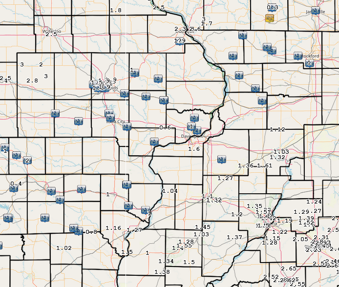
24 hour precipitation reports (in Inches), ....IOWA.... |
 |
Media use of NWS Web News Stories is encouraged! Please acknowledge the NWS as the source of any news information accessed from this site. |
|