Scattered thunderstorms with severe gusts, hail and a tornado risk are possible near a cold front from the Ohio Valley to the Mid-Atlantic tonight. Tropical Storm Bertha is expected to bring tropical storm conditions to portions of the Gulf Coast from the panhandle of Florida into Louisiana through Wednesday. Read More >
Overview
|
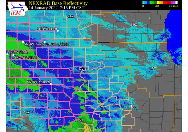
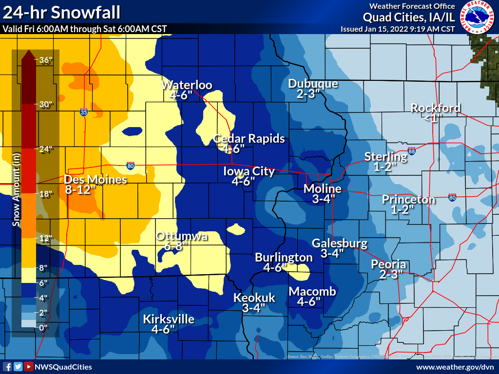
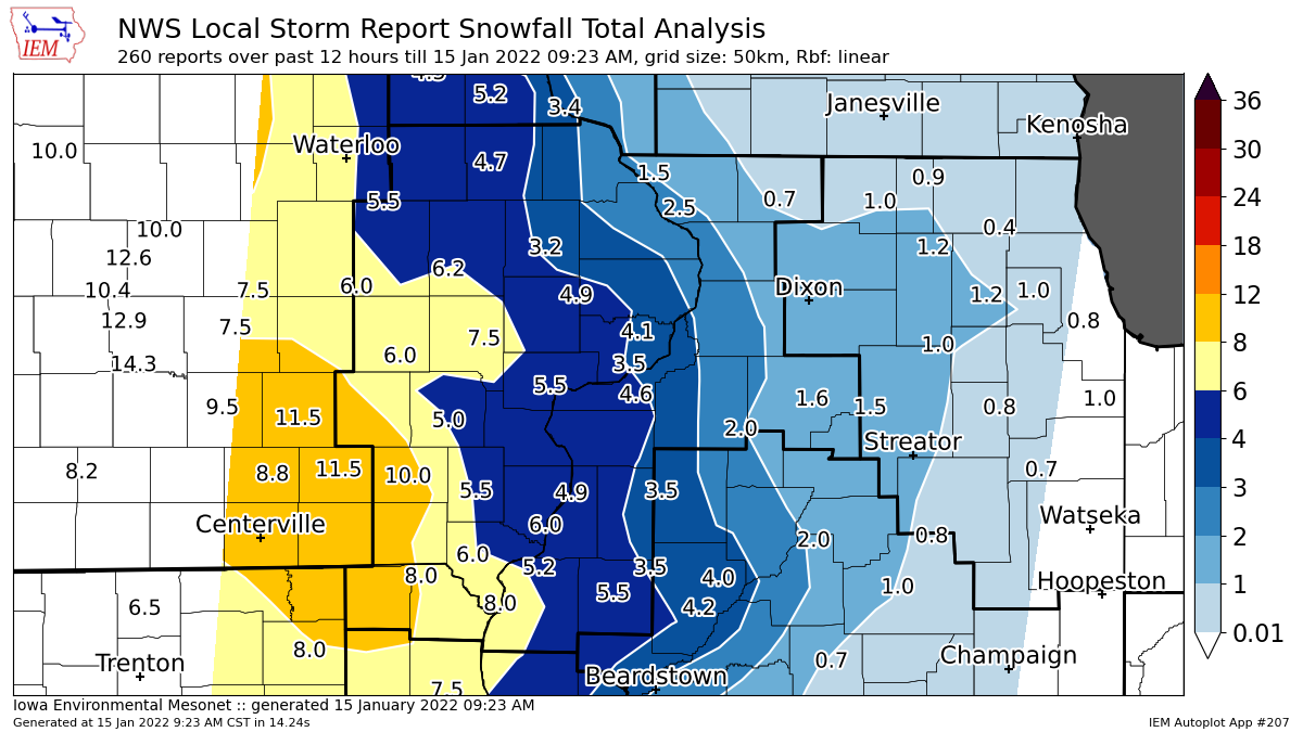
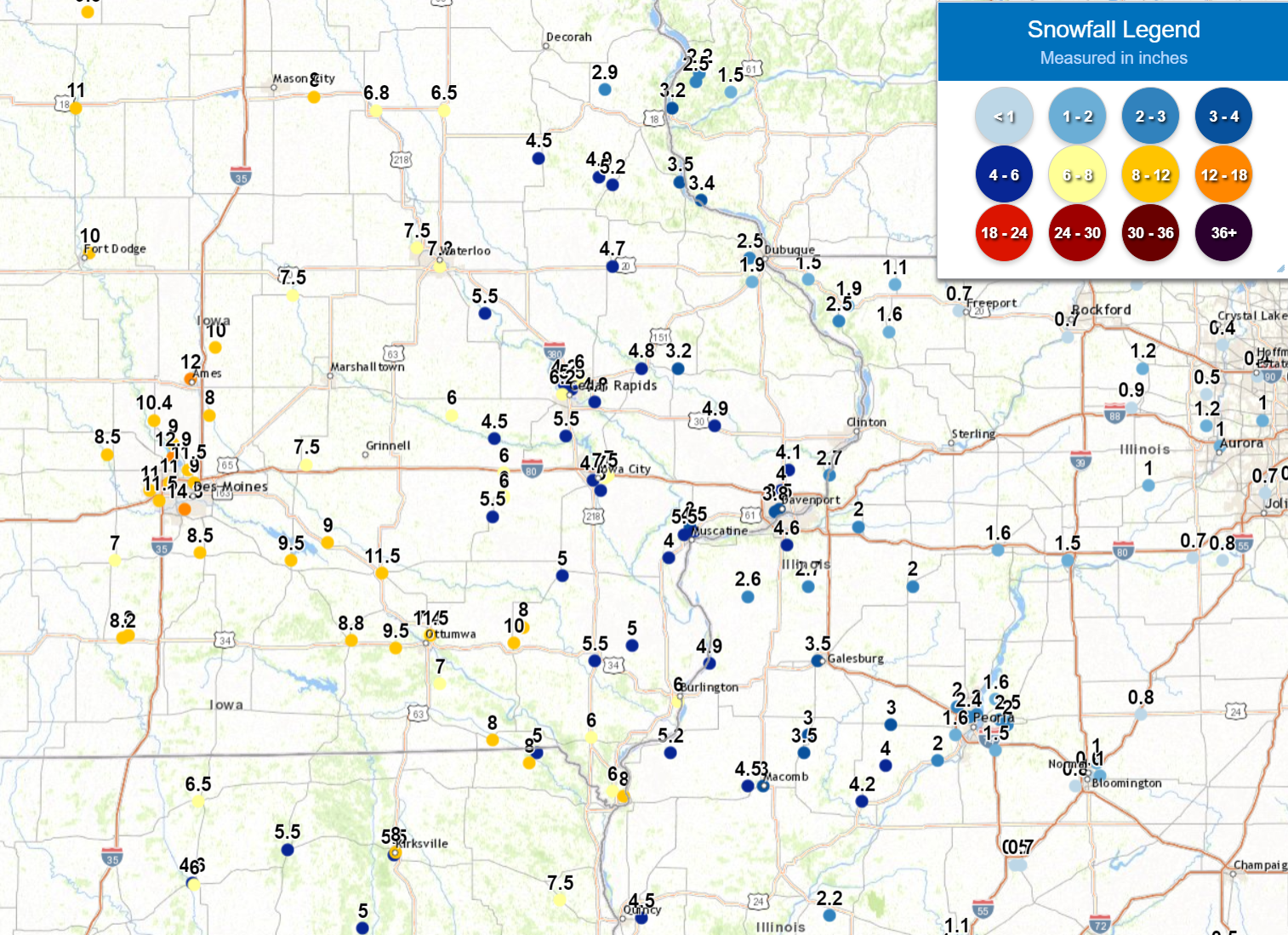
A winter storm brought snow to much of eastern Iowa, northwest Illinois, and northeast Missouri Friday afternoon - early Saturday morning. This snow impacted the evening commute causing hazardous travel, especially between Des Moines and Iowa City on Interstate 80 and along I-380 between Iowa City and Cedar Rapids. The highest snow totals between 8 and 12 inches were common roughly along a line from Des Moines to Keokuk. Snow amounts between 4-7 inches were found across much of eastern Iowa towards west central Illinois. Lesser amounts of 1-3 inches were reported in northern and north central Illinois. Illinois, Iowa, and Missouri DOT reported slick and snow covered roads through much of the event. Winds between 20-30 mph were also seen causing some blowing and drifting of snow. NWS Official Totals Moline: 4.6"
|
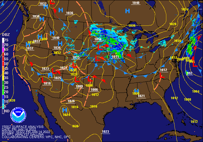 Weather Prediction Center Surface Analysis/Fronts/Radar Loop |
Snow/Rain Maps
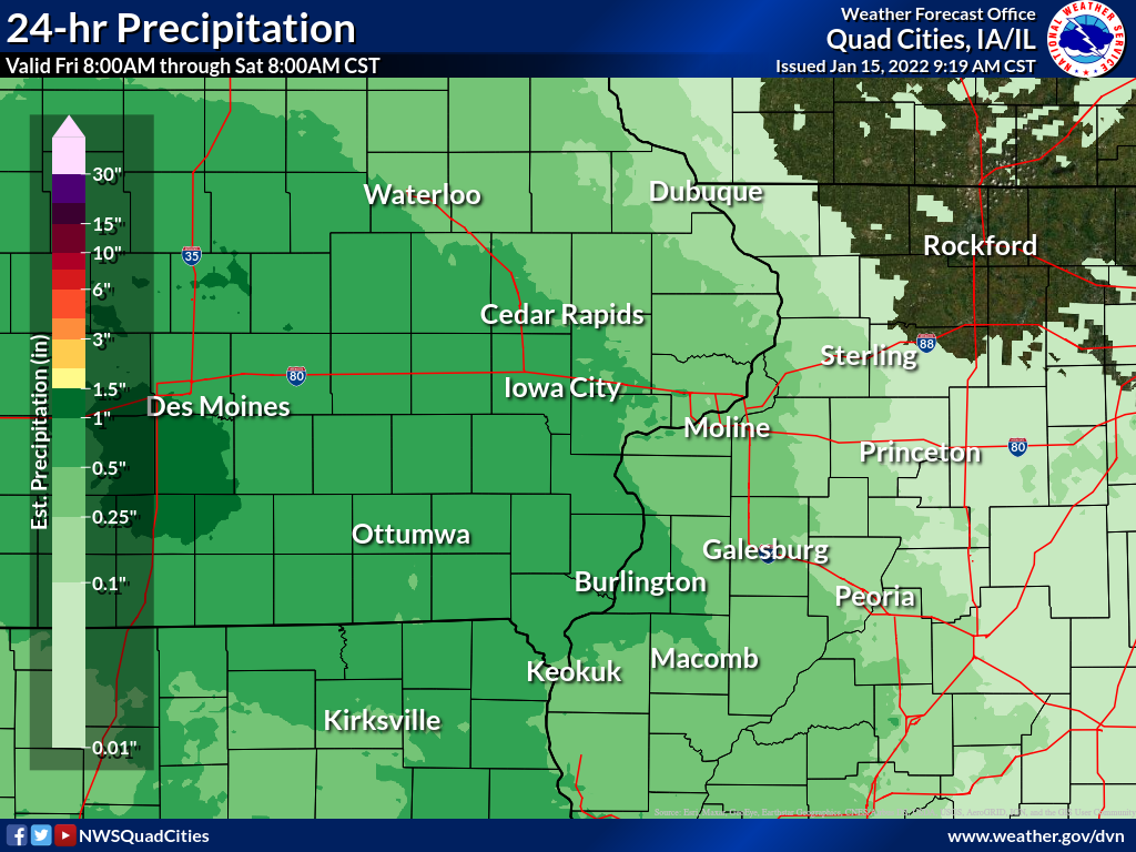
| Local Snowfall Map | Regional Snow Map (courtesy IEM) | Local Snow Analysis (courtesy IEM) |
 |
 |
 |
| Local Liquid Equivalent Map | ||
 |
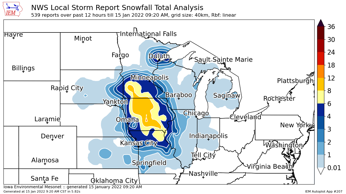
Storm Reports
Storm Reports Map - Courtesy IEM
 |
PRELIMINARY LOCAL STORM REPORT...SUMMARY
NATIONAL WEATHER SERVICE QUAD CITIES IA IL
1027 AM CST SAT JAN 15 2022
..TIME... ...EVENT... ...CITY LOCATION... ...LAT.LON...
..DATE... ....MAG.... ..COUNTY LOCATION..ST.. ...SOURCE....
..REMARKS..
0800 AM SNOW 1 NNE FAIRFIELD 41.02N 91.96W
01/15/2022 M10.0 INCH JEFFERSON IA CO-OP OBSERVER
CO-OP OBSERVER STATION FRFI4 FAIRFIELD.
0456 AM SNOW 1 SW PERLEE 41.08N 91.91W
01/15/2022 M8.0 INCH JEFFERSON IA TRAINED SPOTTER
0600 AM SNOW 1 NE KEOKUK 40.42N 91.39W
01/15/2022 E8.0 INCH LEE IA TRAINED SPOTTER
0818 AM SNOW 2 SSE CHARLIE HEATH MEM 40.55N 91.88W
01/15/2022 E8.0 INCH CLARK MO PUBLIC
0853 AM HEAVY SNOW CANTRIL 40.64N 92.07W
01/15/2022 E8.0 INCH VAN BUREN IA TRAINED SPOTTER
CONSIDERABLE DRIFTING.
0954 AM HEAVY SNOW 1 W SIGOURNEY 41.34N 92.22W
01/15/2022 M7.8 INCH KEOKUK IA TRAINED SPOTTER
STORM TOTAL.
0830 AM SNOW BENTLEY 40.34N 91.11W
01/15/2022 M7.3 INCH HANCOCK IL CO-OP OBSERVER
CO-OP OBSERVER STATION BTYI2 BENTLEY.
0715 AM SNOW 4 ENE IOWA CITY 41.67N 91.47W
01/15/2022 E7.0 INCH JOHNSON IA TRAINED SPOTTER
0800 AM SNOW SIGOURNEY 41.33N 92.20W
01/15/2022 M7.0 INCH KEOKUK IA CO-OP OBSERVER
CO-OP OBSERVER STATION SGYI4 SIGOURNEY.
0919 AM HEAVY SNOW 1 ESE WEST BURLINGTON 40.82N 91.16W
01/15/2022 E7.0 INCH DES MOINES IA PUBLIC
STORM TOTAL.
0930 AM SNOW 1 E LA HARPE 40.58N 90.96W
01/15/2022 M7.0 INCH HANCOCK IL COCORAHS
COCORAHS STATION IL-HN-7 LA HARPE 0.7 E.
0800 AM SNOW 1 ENE VINTON 42.17N 92.01W
01/15/2022 M6.8 INCH BENTON IA CO-OP OBSERVER
CO-OP OBSERVER STATION VNTI4 VINTON.
0700 AM SNOW 2 E IOWA CITY 41.66N 91.49W
01/15/2022 M6.5 INCH JOHNSON IA COCORAHS
COCORAHS STATION IA-JH-34 IOWA CITY 2.3 E.
0842 AM SNOW 2 W CEDAR RAPIDS 41.98N 91.71W
01/15/2022 M6.2 INCH LINN IA TRAINED SPOTTER
STORM TOTAL.
0600 AM SNOW PARNELL 41.58N 92.01W
01/15/2022 M6.0 INCH IOWA IA COCORAHS
COCORAHS STATION IA-IA-13 PARNELL 0.1 SSW.
0700 AM SNOW 1 WNW MARION 42.04N 91.62W
01/15/2022 M6.0 INCH LINN IA TRAINED SPOTTER
STORM TOTAL, DIFFICULT TO MEASURE (AVERAGE
OF 10 LOCATIONS).
0700 AM SNOW DONNELLSON 40.65N 91.56W
01/15/2022 M6.0 INCH LEE IA CO-OP OBSERVER
CO-OP OBSERVER STATION DNNI4 DONNELLSON.
0720 AM SNOW BELLE PLAINE 41.90N 92.28W
01/15/2022 E6.0 INCH BENTON IA TRAINED SPOTTER
STORM TOTAL.
0726 AM SNOW 1 SSW MOOAR 40.44N 91.45W
01/15/2022 M6.0 INCH LEE IA TRAINED SPOTTER
STORM TOTAL.
0737 AM SNOW 1 ENE BURLINGTON REGION 40.79N 91.11W
01/15/2022 M6.0 INCH DES MOINES IA TRAINED SPOTTER
0845 AM SNOW 1 N WILLIAMSBURG 41.68N 92.01W
01/15/2022 M6.0 INCH IOWA IA TRAINED SPOTTER
STORM TOTAL.
0845 AM SNOW AUGUSTA 40.23N 90.95W
01/15/2022 M6.0 INCH HANCOCK IL CO-OP OBSERVER
CO-OP OBSERVER STATION AUGI2 AUGUSTA.
1013 AM HEAVY SNOW DENMARK 40.74N 91.33W
01/15/2022 E6.0 INCH LEE IA PUBLIC
ESTIMATED STORM TOTAL.
0931 AM SNOW AMANA 41.80N 91.88W
01/15/2022 M5.7 INCH IOWA IA TRAINED SPOTTER
STORM TOTAL.
0600 AM SNOW 2 NNW MOUNT AUBURN 42.29N 92.11W
01/15/2022 M5.5 INCH BENTON IA COCORAHS
COCORAHS STATION IA-BT-11 MOUNT AUBURN 2.2
NNW.
0723 AM SNOW 2 NNE CEDAR RAPIDS 42.00N 91.66W
01/15/2022 E5.5 INCH LINN IA PUBLIC
STORM TOTAL.
0740 AM SNOW 1 WSW MOUNT PLEASANT MU 40.95N 91.54W
01/15/2022 M5.5 INCH HENRY IA TRAINED SPOTTER
0830 AM SNOW NORTH ENGLISH 41.51N 92.07W
01/15/2022 M5.5 INCH IOWA IA TRAINED SPOTTER
STORM TOTAL.
0836 AM SNOW 2 NNW MUSCATINE 41.44N 91.08W
01/15/2022 M5.5 INCH MUSCATINE IA TRAINED SPOTTER
UPDATED STORM TOTAL.
0841 AM SNOW 1 WNW COU FALLS 41.82N 91.69W
01/15/2022 M5.5 INCH JOHNSON IA TRAINED SPOTTER
STORM TOTAL.
0935 AM SNOW 1 ENE MOUNT VERNON 41.93N 91.41W
01/15/2022 M5.5 INCH LINN IA TRAINED SPOTTER
STORM TOTAL.
1017 AM SNOW 2 SSE BURLINGTON REGION 40.76N 91.11W
01/15/2022 E5.3 INCH DES MOINES IA TRAINED SPOTTER
STORM TOTAL.
0600 AM SNOW 2 NNE COLUSA 40.59N 91.15W
01/15/2022 M5.2 INCH HANCOCK IL COCORAHS
COCORAHS STATION IL-HN-1 DALLAS CITY 3.0
SSE.
0644 AM SNOW 2 NNE COLUSA 40.59N 91.15W
01/15/2022 M5.2 INCH HANCOCK IL TRAINED SPOTTER
0700 AM SNOW 4 N HASKINS 41.40N 91.54W
01/15/2022 M5.2 INCH WASHINGTON IA COCORAHS
COCORAHS STATION IA-WS-2 AINSWORTH 7.4 N.
0700 AM SNOW 1 SW WASHINGTON 41.28N 91.71W
01/15/2022 M5.0 INCH WASHINGTON IA CO-OP OBSERVER
CO-OP OBSERVER STATION WSHI4 WASHINGTON 2
SSW.
0700 AM SNOW 1 ESE INDEPENDENCE 42.47N 91.88W
01/15/2022 M5.0 INCH BUCHANAN IA COCORAHS
COCORAHS STATION IA-BC-11 INDEPENDENCE 0.6
ESE.
0700 AM SNOW SOLON 41.80N 91.49W
01/15/2022 M5.0 INCH JOHNSON IA COCORAHS
COCORAHS STATION IA-JH-1 SOLON 0.3 ESE.
0700 AM SNOW 2 SW YARMOUTH 41.01N 91.35W
01/15/2022 M5.0 INCH DES MOINES IA COCORAHS
COCORAHS STATION IA-DM-15 2 WSW YARMOUTH.
0700 AM SNOW 3 SE IOWA CITY MUNICIPA 41.61N 91.51W
01/15/2022 M5.0 INCH JOHNSON IA CO-OP OBSERVER
CO-OP OBSERVER STATION ICYI4 IOWA CITY.
0800 AM SNOW 1 SSW NORTH LIBERTY 41.73N 91.62W
01/15/2022 M5.0 INCH JOHNSON IA COCORAHS
COCORAHS STATION IA-JH-27 NORTH LIBERTY 0.7
SSW.
0812 AM SNOW 2 SW YARMOUTH 41.01N 91.35W
01/15/2022 M5.0 INCH DES MOINES IA TRAINED SPOTTER
STORM TOTAL.
0937 AM SNOW IOWA CITY 41.66N 91.53W
01/15/2022 M5.0 INCH JOHNSON IA TRAINED SPOTTER
STORM TOTAL.
0741 AM SNOW LOWDEN 41.86N 90.92W
01/15/2022 M4.9 INCH CEDAR IA CO-OP OBSERVER
STORM TOTAL.
0854 AM HEAVY SNOW OQUAWKA 40.94N 90.95W
01/15/2022 M4.9 INCH HENDERSON IL TRAINED SPOTTER
STORM TOTAL.
0700 AM SNOW 2 ESE FAIRVIEW 42.08N 91.30W
01/15/2022 M4.8 INCH JONES IA CO-OP OBSERVER
CO-OP OBSERVER STATION AMOI4 ANAMOSA 3 SSW.
0823 AM SNOW BERTRAM 41.95N 91.54W
01/15/2022 E4.8 INCH LINN IA PUBLIC
STORM TOTAL.
0700 AM SNOW 1 SSE MANCHESTER 42.47N 91.45W
01/15/2022 M4.7 INCH DELAWARE IA CO-OP OBSERVER
CO-OP OBSERVER STATION MHRI4 MANCHESTER.
0900 AM SNOW UNIVERSITY HEIGHTS 41.65N 91.55W
01/15/2022 M4.7 INCH JOHNSON IA TRAINED SPOTTER
CORRECTS PREVIOUS SNOW REPORT FROM
UNIVERSITY HEIGHTS. STORM TOTAL.
0609 AM SNOW 3 SW QUAD CITY AIRPORT 41.40N 90.55W
01/15/2022 M4.6 INCH ROCK ISLAND IL OFFICIAL NWS OBS
STORM TOTAL.
0441 AM SNOW 3 NE MUSCATINE 41.45N 91.03W
01/15/2022 M4.5 INCH MUSCATINE IA TRAINED SPOTTER
0700 AM SNOW 3 W MACOMB 40.46N 90.75W
01/15/2022 M4.5 INCH MCDONOUGH IL COCORAHS
COCORAHS STATION IL-MCD-7 COLCHESTER 3.5 NE.
0700 AM SNOW 1 NNE MARENGO 41.81N 92.06W
01/15/2022 M4.5 INCH IOWA IA MESONET
MESONET STATION MROI4 1.1 N MARENGO
0800 AM SNOW 3 ESE AMBER 41.11N 91.13W
01/15/2022 M4.4 INCH LOUISA IA COCORAHS
COCORAHS STATION IA-LS-5 WAPELLO 5.4 SE.
0948 AM SNOW 2 NNW NORTH LIBERTY 41.76N 91.62W
01/15/2022 M4.4 INCH JOHNSON IA TRAINED SPOTTER
STORM TOTAL.
0830 AM SNOW 1 E DALLAS CITY 40.63N 91.14W
01/15/2022 M4.3 INCH HANCOCK IL TRAINED SPOTTER
STORM TOTAL.
0425 AM SNOW 2 SSW HIAWATHA 42.02N 91.70W
01/15/2022 M4.2 INCH LINN IA TRAINED SPOTTER
STORM TOTAL SNOWFALL.
0700 AM SNOW PARK VIEW 41.69N 90.54W
01/15/2022 M4.1 INCH SCOTT IA COCORAHS
COCORAHS STATION IA-ST-3 PARK VIEW 0.2 WSW.
0700 AM SNOW 1 SW STRONGHURST 40.74N 90.91W
01/15/2022 M4.1 INCH HENDERSON IL COCORAHS
COCORAHS STATION IL-HD-1 STRONGHURST 0.4
SSW.
0757 AM SNOW 1 NNW MONTICELLO MUNICI 42.24N 91.17W
01/15/2022 M4.1 INCH JONES IA CO-OP OBSERVER
CO-OP OBSERVER STATION MCLI4 MONTICELLO.
0610 AM SNOW DAVENPORT AIRPORT 41.61N 90.58W
01/15/2022 M4.0 INCH SCOTT IA OFFICIAL NWS OBS
STORM TOTAL.
0700 AM SNOW 2 SE COAL VALLEY 41.43N 90.42W
01/15/2022 M4.0 INCH HENRY IL COCORAHS
COCORAHS STATION IL-HY-5 COAL VALLEY 1.9 SE.
0755 AM SNOW 1 SSW MUSCATINE MUNICIP 41.35N 91.16W
01/15/2022 M4.0 INCH MUSCATINE IA TRAINED SPOTTER
STORM TOTAL.
0745 AM SNOW 2 N CREDIT ISLAND 41.53N 90.61W
01/15/2022 M3.8 INCH SCOTT IA TRAINED SPOTTER
0540 AM SNOW 1 SE DAVENPORT 41.54N 90.59W
01/15/2022 M3.5 INCH SCOTT IA COCORAHS
COCORAHS STATION IA-ST-37 DAVENPORT 0.9 WNW.
0600 AM SNOW 2 S PRAIRIE CITY 40.59N 90.46W
01/15/2022 M3.5 INCH MCDONOUGH IL CO-OP OBSERVER
CO-OP OBSERVER STATION PRCI2 2.0 S PRAIRIE
CITY.
0836 AM SNOW 3 SSW CENTER JUNCTION 42.08N 91.11W
01/15/2022 M3.2 INCH JONES IA TRAINED SPOTTER
STORM TOTAL.
0700 AM SNOW 4 NNE MUSCATINE 41.47N 91.05W
01/15/2022 M3.0 INCH MUSCATINE IA CO-OP OBSERVER
CO-OP OBSERVER STATION MSTI4 2 N MUSCATINE.
0914 AM SNOW 1 SE MACOMB 40.46N 90.67W
01/15/2022 M3.0 INCH MCDONOUGH IL TRAINED SPOTTER
0958 AM SNOW INDUSTRY 40.32N 90.61W
01/15/2022 M3.0 INCH MCDONOUGH IL TRAINED SPOTTER
STORM TOTAL.
0702 AM SNOW 2 E GRIFFIN 41.24N 90.44W
01/15/2022 E2.7 INCH HENRY IL TRAINED SPOTTER
STORM TOTAL.
0736 AM SNOW 1 SSW CORDOVA 41.67N 90.33W
01/15/2022 M2.7 INCH ROCK ISLAND IL TRAINED SPOTTER
STORM TOTAL.
0700 AM SNOW ALEDO 41.20N 90.75W
01/15/2022 M2.6 INCH MERCER IL CO-OP OBSERVER
CO-OP OBSERVER STATION ALEI2 ALEDO.
0700 AM SNOW HANOVER 42.26N 90.28W
01/15/2022 M2.5 INCH JO DAVIESS IL COCORAHS
COCORAHS STATION IL-JD-6 HANOVER 0.2 NW.
0740 AM SNOW 2 SE ASBURY 42.50N 90.74W
01/15/2022 M2.5 INCH DUBUQUE IA TRAINED SPOTTER
0700 AM SNOW 1 E KEWANEE 41.24N 89.90W
01/15/2022 M2.0 INCH HENRY IL CO-OP OBSERVER
CO-OP OBSERVER STATION KEWI2 KEWANEE 1 E.
0730 AM SNOW 2 NW GENESEO 41.47N 90.18W
01/15/2022 M2.0 INCH HENRY IL COCORAHS
COCORAHS STATION IL-HY-8 GENESEO 2.0 NW.
0610 AM SNOW 1 NW DUBUQUE REGIONAL A 42.41N 90.73W
01/15/2022 M1.9 INCH DUBUQUE IA OFFICIAL NWS OBS
STORM TOTAL.
0630 AM SNOW ELIZABETH 42.32N 90.23W
01/15/2022 M1.9 INCH JO DAVIESS IL CO-OP OBSERVER
CO-OP OBSERVER STATION EZBI2 ELIZABETH.
0700 AM SNOW PRINCETON 41.38N 89.46W
01/15/2022 M1.6 INCH BUREAU IL CO-OP OBSERVER
CO-OP OBSERVER STATION PTNI2 PRINCETON.
0721 AM SNOW 4 SSE ELMOVILLE 42.22N 90.02W
01/15/2022 E1.6 INCH JO DAVIESS IL PUBLIC
0736 AM SNOW 1 W GALENA 42.42N 90.44W
01/15/2022 M1.5 INCH JO DAVIESS IL TRAINED SPOTTER
0700 AM SNOW 3 NNE STOCKTON 42.40N 89.99W
01/15/2022 M1.1 INCH JO DAVIESS IL COCORAHS
COCORAHS STATION IL-JD-8 STOCKTON 3.4 NNE.
0700 AM SNOW 6 SSE ELMOVILLE 42.19N 90.02W
01/15/2022 M1.0 INCH CARROLL IL COCORAHS
COCORAHS STATION IL-CR-12 MOUNT CARROLL 6.8
NNW.
0830 AM SNOW MOUNT CARROLL 42.10N 89.98W
01/15/2022 M1.0 INCH CARROLL IL CO-OP OBSERVER
CO-OP OBSERVER STATION MTCI2 MOUNT CARROLL.
1018 AM SNOW 3 SW WINNESHIEK 42.32N 89.57W
01/15/2022 E1.0 INCH STEPHENSON IL TRAINED SPOTTER
STORM TOTAL.
0809 AM SNOW 2 WNW FREEPORT 42.30N 89.66W
01/15/2022 M0.7 INCH STEPHENSON IL TRAINED SPOTTER
 |
Media use of NWS Web News Stories is encouraged! Please acknowledge the NWS as the source of any news information accessed from this site. |
|