A significant heat wave is underway for the Intermountain West, Northern Plains, and Upper Great Lakes, peaking in intensity through midweek and lingering across parts of the Northern Plains and Midwest until this weekend. In southwest Texas, excessive rainfall may bring a risk for potentially life-threatening flash and arroyo flooding through Thursday. Read More >
Overview
|
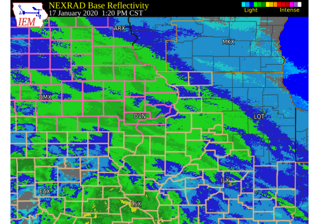
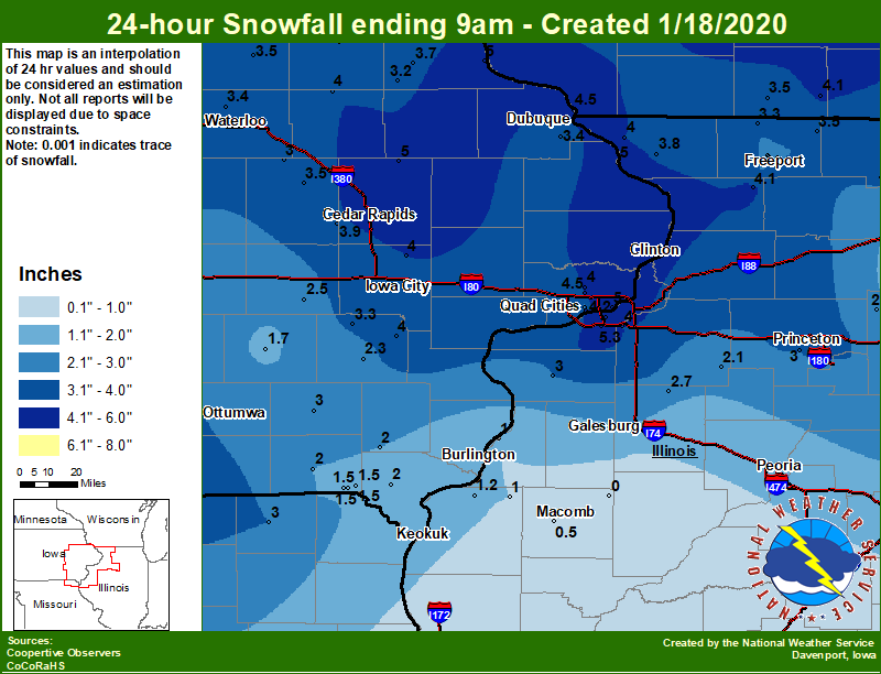
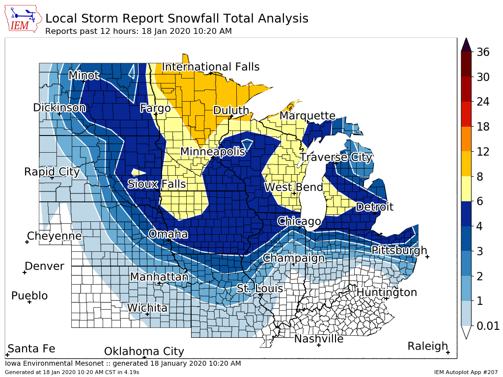
A winter storm spread light to moderate snow across across northeast Missouri, eastern Iowa, and far northwest Illinois late Friday morning into the afternoon. Snow changed over to sleet and freezing rain during the evening hours across most of the area. Snowfall amounts ranged 0.5 inches across west central Illinois to 5.5 inches in far northwest Illinois and area of Iowa north of Interstate 80. Freezing rain reports ranged from a tenth to a quarter of an inch. Strong winds in excess of 40 mph were seen Saturday afternoon as an arctic cold front pushed through the area. This caused some blowing and drifting of snow.
Official NWS Obs: Moline: 5.3" Davenport: 4.5" Dubuque: 3.4" |
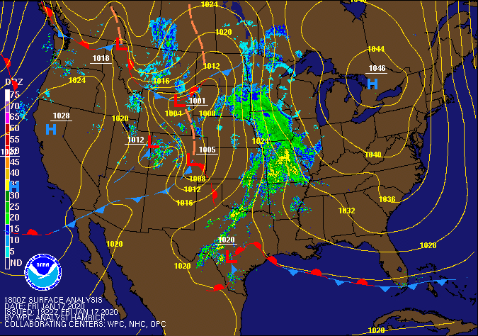 Surface Map 18Z 01/17 |
Snow/Ice
| Local Snowfall Map | Regional Snowfall Map |
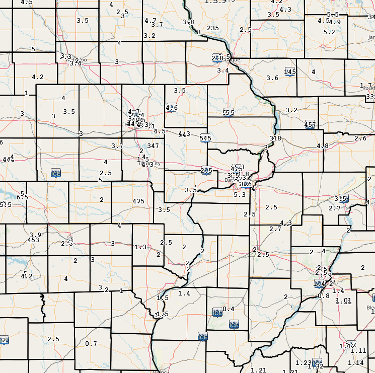
Iowa Snowfall Analysis |
 |
 |
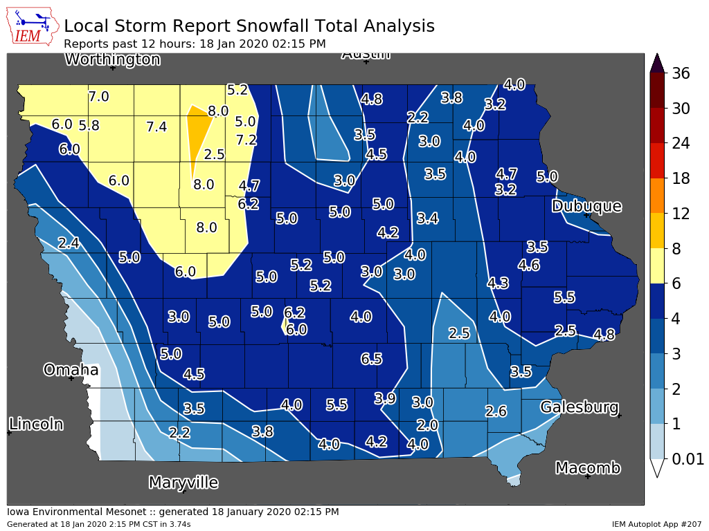 |
....IOWA.... NWS Johnston* 5 NNW 6.2 Bettendorf 2.2 SE 5.0 Bellevue LD12 5.0 Coggon 5.0 Guttenberg Dam 10 5.0 Perry 0 W 4.7 Ames US 30 2 SSE 4.5 Dubuque LD11 4.5 Davenport 0.9 SSW 4.5 Davenport Arpt 4.5 Stanley 4.0 Eldridge 0.7 SSW 4.0 Centerville 0 NE 4.0 Ainsworth 7.4 N 4.0 Newton 1 NE 4.0 Solon 0.3 ESE 4.0 Fairfax 4.0 NW 3.9 Beaconsfield 1 NNE 3.8 Cresco 1 NE 3.8 Elkader 6SSW 3.7 Tripoli 0 N 3.5 Vinton 3.5 Dubuque Arpt 3.4 Waterloo ASOS 5 NW 3.4 Wellman 4.0 E 3.3 Strawberry Point 3.2 Toledo 3 N 3.0 Mount Auburn 2.2 NNW 3.0 Mason City 1 NNE 3.0 Boone 1 SSW 3.0 Marshalltown 1 NW 3.0 Fayette 1 NW 3.0 Hampton 1 N 3.0 Fairfield 3.0 Davenport 0.9 WNW 2.5 Parnell 0.1 SSW 2.5 Washington 2.3 Salem 1S 2.0 Donnellson 2.0 Keosauqua 2.0 Sigourney 1.7 Farmington 3.5 W 1.5 Farmington 0.3 NW 1.5 Farmington 2.4 W 1.5 Farmington 0.4 NNW 1.5 ....ILLINOIS.... Quad City Arpt 5.3 Moline 0.7 NNE 4.2 Shannon 0.2 S 4.1 Princeton 1.1 SE 4.0 Princeton 4.0 Galena 4.0 Coal Valley 2.6 E 4.0 Elizabeth 3.8 Davis 0.5 N 3.5 Winslow 4.3 ESE 3.3 Rockford ASOS 3.2 Aledo 3.0 Mundelein 3.0 Tiskilwa 2.1 N 3.0 Streator 3 SE 3.0 Freeport 2.8 Altona 2.7 Paw Paw 1 E 2.5 Freeport 2.0 NW 2.5 Freeport 2.9 WSW 2.5 Freeport 1.7 NW 2.5 Kewanee 1 E 2.1 Ottawa 4 SW 2.0 Galesburg 2.0 Mendota 2 SE 2.0 Romeoville 1.9 Steward 1.5 Dallas City 3.0 SSE 1.2 La Harpe 1.0 Gladstone LD18 1.0 Colchester 3.5 NE 0.5 St Anne 0.5 Ogden 0.1 Windsor 0.0 Prairie City 2S 0.0 ....MISSOURI.... Memphis 3.0 Columbia 0.0 ....WISCONSIN.... Madison-ASOS 5.2 Brodhead 1 SW 4.1 Whitewater 4.0 Steuben 4SE 3 NE 3.8 Monroe 1 W 3.5 La Crosse WFO 3.3 Viroqua 2.7 ....MINNESOTA.... Theilman 1SSW 4.3 |
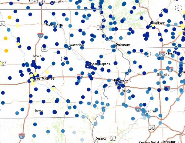
Storm Reports
Storm Reports Map - Courtesy IEM
|
|
 |
PRELIMINARY LOCAL STORM REPORT...SUMMARY
NATIONAL WEATHER SERVICE QUAD CITIES IA IL
1125 AM CST SAT JAN 18 2020
..TIME... ...EVENT... ...CITY LOCATION... ...LAT.LON...
..DATE... ....MAG.... ..COUNTY LOCATION..ST.. ...SOURCE....
..REMARKS..
0659 PM SLEET COLCHESTER 40.43N 90.79W
01/17/2020 M1.0 INCH MCDONOUGH IL TRAINED SPOTTER
HAS CHANGED OVER TO FREEZING RAIN.
0647 PM FREEZING RAIN INDUSTRY 40.33N 90.61W
01/17/2020 M0.05 INCH MCDONOUGH IL TRAINED SPOTTER
2MM OF ICE.
0303 PM SNOW 1 SE MACOMB 40.46N 90.67W
01/17/2020 M0.4 INCH MCDONOUGH IL PUBLIC
0852 AM ICE STORM 3 N STOCKTON 42.40N 90.00W
01/18/2020 JO DAVIESS IL CO-OP OBSERVER
0.25 INCHES OF ICE WITH PICTURE
VERIFICATION.
0852 AM SNOW 3 N STOCKTON 42.40N 90.00W
01/18/2020 M4.0 INCH JO DAVIESS IL CO-OP OBSERVER
SO FAR. ALSO HAD 0.25 INCHES OF ICE
ACCUMULATION.
1011 PM SNOW 2 W WOODBINE 42.35N 90.19W
01/17/2020 M3.6 INCH JO DAVIESS IL TRAINED SPOTTER
SNOW CHANGED TO SLEET BUT HAS STOPPED FOR
THE TIME BEING.
0908 PM SNOW 3 N STOCKTON 42.40N 90.00W
01/17/2020 M3.0 INCH JO DAVIESS IL CO-OP OBSERVER
.
0951 PM SNOW GALVA 41.17N 90.04W
01/17/2020 M4.3 INCH HENRY IL TRAINED SPOTTER
REPORTED 4.25 INCHES OF SNOW AND SLEET.
0838 PM SNOW 2 E GRIFFIN 41.24N 90.44W
01/17/2020 M2.5 INCH HENRY IL TRAINED SPOTTER
SNOW HAS CHANGED OVER TO FREEZING RAIN.
0419 PM SNOW CAMBRIDGE 41.30N 90.20W
01/17/2020 M2.5 INCH HENRY IL TRAINED SPOTTER
UPDATES PREVIOUS SNOW REPORT FROM CAMBRIDGE.
A LIGHT MIST OR FREEZING DRIZZLE IS FALLING.
0552 PM SNOW 1 NE OQUAWKA 40.94N 90.95W
01/17/2020 M2.0 INCH HENDERSON IL PUBLIC
1017 AM ICE STORM AUGUSTA 40.23N 90.95W
01/18/2020 HANCOCK IL CO-OP OBSERVER
0.25 INCHES OF ICE ON TREES/POWER LINES WITH
1.5 INCHES OF SNOW.
0905 PM SNOW 2 NE COLUSA 40.59N 91.15W
01/17/2020 M1.4 INCH HANCOCK IL PUBLIC
0223 PM SNOW NAUVOO 40.55N 91.39W
01/17/2020 M1.5 INCH HANCOCK IL PUBLIC
0850 AM FREEZING RAIN MILLEDGEVILLE 41.97N 89.78W
01/18/2020 M0.15 INCH CARROLL IL TRAINED SPOTTER
15 HUNDREDTHS ICE WITH AN ADDITIONAL DUSTING
OF SNOW.
1150 PM SNOW MILLEDGEVILLE 41.97N 89.78W
01/17/2020 M5.0 INCH CARROLL IL TRAINED SPOTTER
TOTAL SO FAR. A LITTLE SLEET TOO. FREEZING
RAIN NOW.
1004 PM SNOW MOUNT CARROLL 42.09N 89.98W
01/17/2020 M3.2 INCH CARROLL IL PUBLIC
0757 PM SNOW MILLEDGEVILLE 41.97N 89.78W
01/17/2020 M4.7 INCH CARROLL IL TRAINED SPOTTER
1030 PM FREEZING RAIN 2 W COAL HOLLOW 41.37N 89.41W
01/17/2020 U0.00 INCH BUREAU IL EMERGENCY MNGR
ICY CONDITIONS FROM FREEZING RAIN ON
INTERSTATE 80 LEADING TO MULTIPLE ACCIDENTS.
0807 PM SNOW 1 SE PRINCETON 41.37N 89.45W
01/17/2020 M3.5 INCH BUREAU IL CO-OP OBSERVER
STILL SNOWING.
0800 PM SNOW TISKILWA 41.29N 89.51W
01/17/2020 M2.7 INCH BUREAU IL TRAINED SPOTTER
0412 PM SNOW 1 SE PRINCETON 41.37N 89.45W
01/17/2020 M1.0 INCH BUREAU IL CO-OP OBSERVER
LIGHT TO MODERATE SNOW STILL FALLING.
0908 PM SNOW 4 NE WASHINGTON 41.35N 91.65W
01/17/2020 M4.5 INCH WASHINGTON IA PUBLIC
0322 PM SNOW 4 NE WASHINGTON 41.35N 91.65W
01/17/2020 M3.0 INCH WASHINGTON IA PUBLIC
0513 PM SNOW SELMA 40.87N 92.15W
01/17/2020 M3.0 INCH VAN BUREN IA TRAINED SPOTTER
SNOW BEGAN AT 11 AM. LIGHT SLEET IS FALLING
NOW.
0428 PM SNOW CANTRIL 40.64N 92.07W
01/17/2020 M3.0 INCH VAN BUREN IA TRAINED SPOTTER
CORRECTS PREVIOUS SNOW REPORT FROM CANTRILL
THAT PRECIPITATION HAS CHANGED OVER TO ALL
FREEZING RAIN.
0427 PM SNOW CANTRIL 40.64N 92.07W
01/17/2020 M3.0 INCH VAN BUREN IA TRAINED SPOTTER
0210 PM SNOW 3 W MOUNT STERLING 40.62N 92.00W
01/17/2020 M2.0 INCH VAN BUREN IA TRAINED SPOTTER
STILL SNOWING.
0858 AM SNOW 1 NW DAVENPORT 41.56N 90.62W
01/18/2020 M3.5 INCH SCOTT IA TRAINED SPOTTER
SO FAR WITH A GOOD GLAZE ON TOP OF THE SNOW.
0823 AM SNOW 2 W BETTENDORF 41.57N 90.51W
01/18/2020 M4.8 INCH SCOTT IA PUBLIC
1255 AM FREEZING RAIN DAVENPORT AIRPORT 41.61N 90.58W
01/18/2020 M0.20 INCH SCOTT IA OFFICIAL NWS OBS
ICE ACCUMULATION OF UP TO TWO TENTHS OF AN
INCH.
1240 AM SNOW DAVENPORT AIRPORT 41.61N 90.58W
01/18/2020 M4.5 INCH SCOTT IA OFFICIAL NWS OBS
24 HOUR TOTAL.
0840 PM SNOW 3 ESE DAVENPORT 41.54N 90.54W
01/17/2020 M5.3 INCH SCOTT IA NWS EMPLOYEE
UPDATES PREVIOUS SNOW REPORT FROM 3 ESE
DAVENPORT.
0831 PM SNOW 2 S DAVENPORT 41.53N 90.61W
01/17/2020 M4.0 INCH SCOTT IA PUBLIC
0811 PM SNOW DAVENPORT 41.56N 90.60W
01/17/2020 M5.8 INCH SCOTT IA TRAINED SPOTTER
0718 PM SNOW 2 W BETTENDORF 41.57N 90.51W
01/17/2020 M4.4 INCH SCOTT IA NWS EMPLOYEE
0609 PM SNOW DAVENPORT MUNICIPALITY 41.62N 90.58W
01/17/2020 E2.1 INCH SCOTT IA OFFICIAL NWS OBS
0603 PM SNOW 2 NNE CREDIT ISLAND 41.52N 90.60W
01/17/2020 M3.0 INCH SCOTT IA TRAINED SPOTTER
0526 PM SNOW 1 NNW MOUNT JOY 41.63N 90.56W
01/17/2020 E2.8 INCH SCOTT IA NWS EMPLOYEE
0436 PM SNOW 3 NNW DAVENPORT 41.59N 90.62W
01/17/2020 M1.0 INCH SCOTT IA TRAINED SPOTTER
3/4 INCH IN THE LAST HOUR.
0615 PM SNOW 2 NNW MUSCATINE 41.44N 91.08W
01/17/2020 M3.5 INCH MUSCATINE IA TRAINED SPOTTER
UPDATES PREVIOUS SNOW REPORT FROM 2 NNW
MUSCATINE. SNOW HAS A CRUST ON IT NOW AND NO
PRECIPITATION IS FALLING AT THE MOMENT.
0545 PM SNOW 3 NE MUSCATINE 41.46N 91.03W
01/17/2020 M4.0 INCH MUSCATINE IA PUBLIC
0258 PM SNOW 2 NNW MUSCATINE 41.44N 91.08W
01/17/2020 E1.9 INCH MUSCATINE IA TRAINED SPOTTER
0741 AM SNOW COLUMBUS JUNCTION 41.28N 91.37W
01/18/2020 E3.5 INCH LOUISA IA TRAINED SPOTTER
ESTIMATED AMOUNT SO FAR.
0235 AM SNOW 3 E CEDAR RAPIDS 41.97N 91.61W
01/18/2020 E4.3 INCH LINN IA TRAINED SPOTTER
ABOUT 4.25 INCHES OF SNOW WITH ABOUT AN
EIGHTH OF AN INCH OF ICE ON TOP.
1254 AM FREEZING RAIN HIAWATHA 42.05N 91.68W
01/18/2020 M0.15 INCH LINN IA TRAINED SPOTTER
RIGHT BETWEEN A TENTH AND TWO TENTHS OF AN
INCH.
1010 PM SNOW CEDAR RAPIDS NE 41.98N 91.67W
01/17/2020 M4.6 INCH LINN IA BROADCAST MEDIA
PRECIPITATION VARIES BETWEEN SLEET AND
FREEZING RAIN.
0949 PM SNOW 2 NW MARION 42.05N 91.61W
01/17/2020 E4.0 INCH LINN IA TRAINED SPOTTER
0645 PM SNOW 2 W CEDAR RAPIDS 41.98N 91.71W
01/17/2020 M4.5 INCH LINN IA TRAINED SPOTTER
UPDATES PREVIOUS SNOW REPORT FROM 2 W CEDAR
RAPIDS. UPDATES THE PREVIOUS SNOW REPORT
FROM 2 W CEDAR RAPIDS OF 1.6 INCHES. STILL
SNOWING.
0635 PM SNOW 3 NNE CEDAR RAPIDS 42.01N 91.66W
01/17/2020 M4.4 INCH LINN IA TRAINED SPOTTER
SNOW HAS CHANGED OVER TO FREEZING RAIN.
0620 PM SNOW 2 NE CEDAR RAPIDS 41.99N 91.65W
01/17/2020 M5.0 INCH LINN IA PUBLIC
0531 PM SNOW 2 S MIDWAY 42.08N 91.70W
01/17/2020 E4.7 INCH LINN IA PUBLIC
0527 PM SNOW BERTRAM 41.96N 91.53W
01/17/2020 E4.1 INCH LINN IA TRAINED SPOTTER
0525 PM SNOW MOUNT VERNON 41.92N 91.42W
01/17/2020 M4.5 INCH LINN IA TRAINED SPOTTER
UPDATES PREVIOUS SNOW REPORT FROM MOUNT
VERNON.
0520 PM SNOW 3 NE CEDAR RAPIDS 42.01N 91.64W
01/17/2020 M3.6 INCH LINN IA PUBLIC
0444 PM SNOW 2 SSW HIAWATHA 42.02N 91.70W
01/17/2020 M4.0 INCH LINN IA TRAINED SPOTTER
UPDATES PREVIOUS SNOW REPORT FROM 2 SSW
HIAWATHA. ALSO ABOUT A TENTH OF AN INCH OF
ICE.
0337 PM SNOW HIAWATHA 42.05N 91.68W
01/17/2020 M2.5 INCH LINN IA TRAINED SPOTTER
0301 PM SNOW 1 NW CEDAR RAPIDS 41.99N 91.68W
01/17/2020 M2.5 INCH LINN IA BROADCAST MEDIA
0229 PM SNOW CEDAR RAPIDS 41.98N 91.67W
01/17/2020 E3.2 INCH LINN IA BROADCAST MEDIA
UPDATED PREVIOUS SNOW REPORT FROM CEDAR
RAPIDS OF 1.8 INCHES.
0506 PM SNOW 1 NE KEOKUK 40.42N 91.39W
01/17/2020 M1.5 INCH LEE IA TRAINED SPOTTER
SNOW HAS QUIT AND TRANSITIONED TO FREEZING
RAIN.
0338 PM SNOW KEOKUK 40.41N 91.41W
01/17/2020 E1.5 INCH LEE IA TRAINED SPOTTER
SNOW WAS CHANGING OVER TO SLEET.
1240 PM SNOW HARPER 41.36N 92.05W
01/17/2020 M2.0 INCH KEOKUK IA PUBLIC
0911 AM SNOW 1 NNW MONTICELLO 42.25N 91.20W
01/18/2020 M3.5 INCH JONES IA TRAINED SPOTTER
STORM TOTAL SNOWFALL. A GLAZE OF ICE.
0828 AM SNOW ANAMOSA 42.11N 91.29W
01/18/2020 M4.6 INCH JONES IA TRAINED SPOTTER
SO FAR. ICE ACCUMULATION OF 0.05 INCHES.
0756 PM SNOW ANAMOSA 42.11N 91.29W
01/17/2020 M4.4 INCH JONES IA PUBLIC
0651 PM SNOW ANAMOSA 42.11N 91.29W
01/17/2020 M4.3 INCH JONES IA TRAINED SPOTTER
CORRECTS PREVIOUS FREEZING RAIN REPORT THAT
SHOULD HAVE BEEN SNOW FROM ANAMOSA.
0540 PM SNOW ANAMOSA 42.11N 91.29W
01/17/2020 M4.3 INCH JONES IA PUBLIC
0449 PM SNOW ANAMOSA 42.11N 91.28W
01/17/2020 M3.5 INCH JONES IA PUBLIC
0444 PM SNOW ANAMOSA 42.11N 91.29W
01/17/2020 M3.3 INCH JONES IA PUBLIC
0442 PM SNOW ANAMOSA 42.11N 91.29W
01/17/2020 M3.3 INCH JONES IA PUBLIC
0336 PM SNOW ANAMOSA 42.11N 91.29W
01/17/2020 M2.1 INCH JONES IA PUBLIC
0227 PM SNOW ANAMOSA 42.11N 91.29W
01/17/2020 M1.2 INCH JONES IA PUBLIC
0917 AM SNOW 1 N OAKDALE 41.71N 91.59W
01/18/2020 M4.0 INCH JOHNSON IA PUBLIC
1100 PM SNOW SOLON 41.80N 91.49W
01/17/2020 M4.0 INCH JOHNSON IA TRAINED SPOTTER
UPDATED SNOW AND SLEET TOTAL. PREVIOUS
REPORT WAS 3.7 INCHES. PRECIPITATION STILL
FALLING.
0837 PM SNOW 2 NNW NORTH LIBERTY 41.76N 91.62W
01/17/2020 M2.0 INCH JOHNSON IA TRAINED SPOTTER
UPDATES PREVIOUS SNOW REPORT FROM 2 NNW
NORTH LIBERTY. CURRENTLY FREEZING RAIN IS
FALLING.
0806 PM SNOW UNIVERSITY HEIGHTS 41.65N 91.55W
01/17/2020 M4.3 INCH JOHNSON IA TRAINED SPOTTER
0309 PM SNOW UNIVERSITY HEIGHTS 41.65N 91.55W
01/17/2020 M2.1 INCH JOHNSON IA TRAINED SPOTTER
STILL SNOWING. WINDS INCREASING.
0231 PM SNOW CORALVILLE 41.69N 91.60W
01/17/2020 M1.5 INCH JOHNSON IA PUBLIC
SNOW BEGAN AT 1215 PM. REPORT VIA TWITTER.
0906 PM SNOW 2 ESE FAIRFIELD 41.00N 91.93W
01/17/2020 M3.0 INCH JEFFERSON IA TRAINED SPOTTER
0725 PM SNOW PLEASANT PLAIN 41.15N 91.86W
01/17/2020 M4.0 INCH JEFFERSON IA PUBLIC
0745 PM SNOW 1 WNW MAQUOKETA 42.07N 90.68W
01/17/2020 M5.0 INCH JACKSON IA TRAINED SPOTTER
UPDATED SNOW TOTAL. SNOW AND SLEET MIXING
FALLING AT THIS TIME.
0653 PM SNOW MAQUOKETA 42.07N 90.67W
01/17/2020 M5.5 INCH JACKSON IA PUBLIC
CORRECTS PREVIOUS FREEZING RAIN REPORT WHICH
SHOULD HAVE BEEN SNOW FROM MAQUOKETA. VIA
TWITTER.
0342 PM SNOW 1 WNW MAQUOKETA 42.07N 90.68W
01/17/2020 M2.0 INCH JACKSON IA TRAINED SPOTTER
0711 AM SNOW PARNELL 41.58N 92.01W
01/18/2020 M2.5 INCH IOWA IA TRAINED SPOTTER
AMOUNT OF SNOW SO FAR. ALSO HAD 0.2 INCHES
OF ICE.
0834 PM SNOW 1 W AMANA 41.80N 91.88W
01/17/2020 M3.7 INCH IOWA IA PUBLIC
0823 PM SNOW NORTH ENGLISH 41.52N 92.07W
01/17/2020 M5.0 INCH IOWA IA TRAINED SPOTTER
FREEZING DRIZZLE CURRENTLY.
0625 PM SNOW WILLIAMSBURG 41.67N 92.01W
01/17/2020 M4.0 INCH IOWA IA PUBLIC
RELAYED BY KCRG.
0348 PM SNOW PARNELL 41.58N 92.01W
01/17/2020 M2.3 INCH IOWA IA TRAINED SPOTTER
0510 PM FREEZING RAIN 1 S MOUNT PLEASANT MUNI 40.93N 91.52W
01/17/2020 UNAN INCH HENRY IA PUBLIC
0451 PM SNOW 2 SW NEW LONDON 40.91N 91.43W
01/17/2020 E2.0 INCH HENRY IA TRAINED SPOTTER
SNOW HAS CHANGED OVER TO FREEZING RAIN.
0115 PM SNOW 2 NNW OAKLAND MILLS 40.97N 91.63W
01/17/2020 M1.3 INCH HENRY IA TRAINED SPOTTER
SNOW BEGAN 11 AM. STILL SNOWING.
1200 AM SNOW DUBUQUE REGIONAL ARPT 42.41N 90.73W
01/18/2020 M3.4 INCH DUBUQUE IA OFFICIAL NWS OBS
24 HOUR TOTAL.
0732 PM FREEZING RAIN 1 E LORE 42.51N 90.79W
01/17/2020 E0.01 INCH DUBUQUE IA PUBLIC
0730 PM SNOW LORE 42.51N 90.79W
01/17/2020 M2.8 INCH DUBUQUE IA PUBLIC
0606 PM SNOW DUBUQUE REGIONAL ARPT 42.41N 90.73W
01/17/2020 M2.4 INCH DUBUQUE IA OFFICIAL NWS OBS
0453 PM SNOW 2 WNW DUBUQUE 42.52N 90.72W
01/17/2020 M3.5 INCH DUBUQUE IA TRAINED SPOTTER
1.5 FOOT DRIFTS. STILL SNOWING.
1026 PM SNOW 2 N SPERRY 40.97N 91.15W
01/17/2020 M2.0 INCH DES MOINES IA PUBLIC
0528 PM SNOW 2 N BURLINGTON 40.84N 91.12W
01/17/2020 E2.0 INCH DES MOINES IA TRAINED SPOTTER
0520 PM SNOW 1 ENE BURLINGTON REGION 40.79N 91.11W
01/17/2020 M2.0 INCH DES MOINES IA TRAINED SPOTTER
WINTRY MIX FALLING THE LAST 40 MINUTES.
0447 PM SNOW 2 SW YARMOUTH 41.01N 91.35W
01/17/2020 M2.5 INCH DES MOINES IA PUBLIC
0718 PM SNOW CAMANCHE 41.79N 90.26W
01/17/2020 M3.0 INCH CLINTON IA CO-OP OBSERVER
0915 AM SNOW LOWDEN 41.86N 90.92W
01/18/2020 M5.5 INCH CEDAR IA CO-OP OBSERVER
UPDATED PREVIOUS SNOW REPORT FROM LOWDEN.
AMOUNT SO FAR. ALSO HAD 0.1 INCHES OF ICE
ACCUMULATION.
0915 AM SNOW DURANT 41.60N 90.91W
01/18/2020 E2.5 INCH CEDAR IA TRAINED SPOTTER
HARD TO MEASURE DUE TO DRIFTING YESTERDAY
AND SO AMOUNT IS AN ESTIMATE. ALSO MEASURED
0.25 OF ICE ACCUMULATION.
0915 AM ICE STORM DURANT 41.60N 90.91W
01/18/2020 CEDAR IA TRAINED SPOTTER
0.25 INCHES OF ICE.
0739 AM SNOW STANWOOD 41.89N 91.15W
01/18/2020 M4.0 INCH CEDAR IA TRAINED SPOTTER
SO FAR. ALSO HAVE A GLAZE CRUST OVER THE
SNOW.
1215 AM FREEZING RAIN LOWDEN 41.86N 90.92W
01/18/2020 E0.10 INCH CEDAR IA CO-OP OBSERVER
UPDATES PREVIOUS REPORT FROM LOWDEN.
FREEZING RAIN IS CURRENTLY FALLING. STORM
TOTAL SNOWFALL REMAINS AT 5.2 INCHES.
0803 PM SNOW STANWOOD 41.90N 91.15W
01/17/2020 M4.3 INCH CEDAR IA TRAINED SPOTTER
SNOW HAS CHANGED OVER TO SLEET.
0302 PM SNOW STANWOOD 41.89N 91.15W
01/17/2020 M1.6 INCH CEDAR IA TRAINED SPOTTER
1130 PM SNOW 4 W STANLEY 42.63N 91.86W
01/17/2020 M4.0 INCH BUCHANAN IA CO-OP OBSERVER
TOTAL SO FAR, SLEET NOW COATING SNOW COVER.
0500 PM SNOW 1 N INDEPENDENCE 42.48N 91.89W
01/17/2020 M3.0 INCH BUCHANAN IA PUBLIC
0510 PM SNOW BELLE PLAINE 41.90N 92.28W
01/17/2020 E3.0 INCH BENTON IA TRAINED SPOTTER
 |
Media use of NWS Web News Stories is encouraged! Please acknowledge the NWS as the source of any news information accessed from this site. |
|