Dangerous heat will expand from the Gulf Coast into the Southern Plains and Desert Southwest through week's end. Additional extreme heat impacting the Pacific Northwest will shift to the northern Plains by the weekend. Tropical Storm Bertha is expected to continue to impact portions of the northern Gulf Coast from the western Florida Panhandle to southeastern Louisiana through tonight. Read More >
|
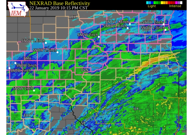
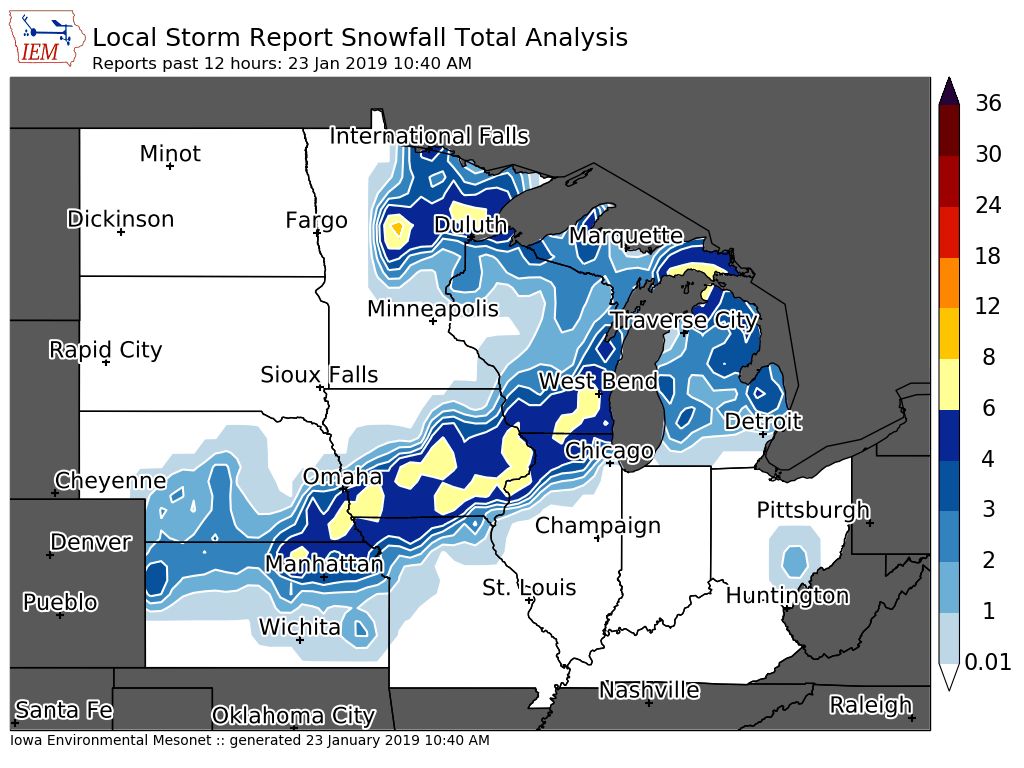
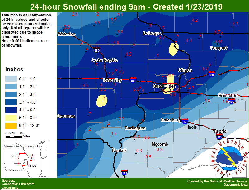
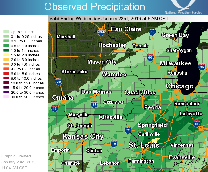
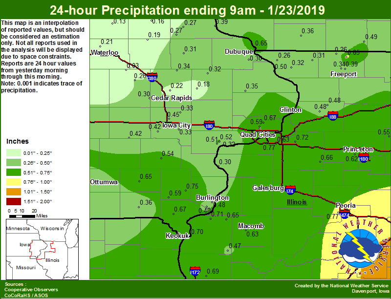
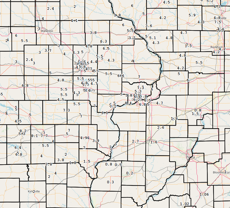
A significant winter storm system brought hazardous travel conditions to the region the afternoon and evening of Tuesday, Jan. 22, through the morning of Wednesday, Jan. 23. Freezing drizzle and rain fell for much of the morning and afternoon on Tuesday causing slick roads. Precipitation quickly changed to snow mainly north of a line from Keokuk, IA to Galesburg, IL, to Priceton, IL. Snowfall totals of 2 to 6 inches were common over much of eastern Iowa and northwest Illinois. Rainfall totals over three quarters of an inch were seen over west central and north central Illinois. |
 Surface Maps |
Maps
| Regional Snowfall January 23rd, 2019 |
Local Snowfall January 23rd, 2019 |
 |
 |
| Courtesy: IEM | |
| Regional Precipitation | Local Precipitation |
 |
 |
 |
| Courtesy: Iowa Environmental Mesonet |
PRELIMINARY LOCAL STORM REPORT...SUMMARY NATIONAL WEATHER SERVICE QUAD CITIES IA IL 335 PM CST WED JAN 23 2019 THE REPORTS BELOW ARE SEPARATED BY AMOUNT. THEY ARE NOT NECESSARILY THE FINAL AMOUNT FOR EACH LOCATION. SNOW REPORTS LISTED BY AMOUNT INCHES LOCATION ST COUNTY TIME ------ ----------------------- -- -------------- ------- 8.6 MOLINE QUAD-CITY AIRPOR IL ROCK ISLAND 1154 AM 8.4 1 ENE MONTPELIER IA SCOTT 0903 AM 7.5 FREEPORT IL STEPHENSON 1037 AM 7.3 PARK VIEW IA SCOTT 0933 AM 7.3 KEOTA IA KEOKUK 0802 AM 7.2 1 NNE MOLINE IL ROCK ISLAND 1253 PM 7.2 MUSCATINE IA MUSCATINE 0942 AM 7.0 1 WNW FREEPORT IL STEPHENSON 1048 AM 7.0 4 S LONE TREE IA JOHNSON 0815 AM 7.0 3 NW DEWITT IA CLINTON 0732 AM 7.0 1 SW PERLEE IA JEFFERSON 0711 AM 7.0 1 W WASHINGTON AIRPORT IA WASHINGTON 0700 AM 7.0 BELLEVUE IA JACKSON 0700 AM 7.0 1 W WASHINGTON IA WASHINGTON 0655 AM 6.8 DAVENPORT IA SCOTT 0910 AM 6.8 2 NNW DAVENPORT IA SCOTT 0743 AM 6.6 1 SSW ELDRIDGE IA SCOTT 1000 AM 6.6 LOWDEN IA CEDAR 0732 AM 6.5 SILVIS IL ROCK ISLAND 0943 AM 6.5 1 E DAVENPORT IA SCOTT 0847 AM 6.5 1 NNW MONTICELLO IA JONES 0841 AM 6.5 1 SE DAVENPORT IA SCOTT 0700 AM 6.4 DAVENPORT MUNICIPALITY IA SCOTT 1155 AM 6.3 HOPKINTON IA DELAWARE 0847 AM 6.3 1 N CREDIT ISLAND IA SCOTT 0735 AM 6.2 2 SSE SCHAPVILLE IL JO DAVIESS 0131 PM 6.2 PARNELL IA IOWA 1035 AM 6.2 MUSCATINE IA MUSCATINE 0858 AM 6.2 1 N PARK VIEW IA SCOTT 0802 AM 6.1 2 W MARION IA LINN 0921 AM 6.1 LETTS IA LOUISA 0823 AM 6.0 2 NE CEDAR RAPIDS IA LINN 0236 PM 6.0 2 NE MUSCATINE IA MUSCATINE 0124 PM 6.0 1 N DUBUQUE IA DUBUQUE 0100 PM 6.0 1 E NORA IL JO DAVIESS 1049 AM 6.0 3 E STERLING IL WHITESIDE 1043 AM 6.0 1 ENE RIVERDALE IA SCOTT 0630 AM 6.0 2 ESE EDMORE IA DUBUQUE 0600 AM 6.0 RICKARDSVILLE IA DUBUQUE 0600 AM 6.0 2 SSE DAVENPORT IA SCOTT 0530 AM 5.8 1 S WALCOTT IA SCOTT 1003 AM 5.8 2 NNW MUSCATINE IA MUSCATINE 0920 AM 5.6 1 NE CEDAR RAPIDS IA LINN 0913 AM 5.5 2 SW SAINT DONATUS IA JACKSON 1142 AM 5.5 2 NNE STONE CITY IA JONES 1015 AM 5.5 2 SE ASBURY IA DUBUQUE 0953 AM 5.5 WILLIAMSBURG IA IOWA 0928 AM 5.5 SOLON IA JOHNSON 0910 AM 5.5 STANWOOD IA CEDAR 0902 AM 5.5 1 W COU FALLS IA JOHNSON 0855 AM 5.5 HIAWATHA IA LINN 0841 AM 5.5 2 N MUSCATINE IA MUSCATINE 0700 AM 5.5 3 W RICHMOND IA WASHINGTON 0630 AM 5.5 FREEPORT IL STEPHENSON 0614 AM 5.5 PARNELL IA IOWA 0525 AM 5.4 1 SW UNIVERSITY HEIGHTS IA JOHNSON 1021 AM 5.4 2 NNE CEDAR RAPIDS IA LINN 0851 AM 5.2 DUBUQUE REGIONAL ARPT IA DUBUQUE 1226 PM 5.1 1 E GALENA TERRITORY IL JO DAVIESS 0715 AM 5.0 3 WSW BETTENDORF IA SCOTT 0121 PM 5.0 2 NW MARION IA LINN 1015 AM 5.0 DURANT IA CEDAR 0930 AM 5.0 1 NE MOUNT VERNON IA LINN 0917 AM 5.0 BELLE PLAINE IA BENTON 0917 AM 5.0 2 NNW MARION IA LINN 0908 AM 5.0 CEDAR RAPIDS IA LINN 0811 AM 5.0 2 NNE FAIRFIELD IA JEFFERSON 0800 AM 5.0 4 NNE LAFAYETTE IA LINN 0800 AM 5.0 SOLON IA JOHNSON 0800 AM 5.0 4 NNW ELY IA LINN 0740 AM 5.0 1 SSW DAVENPORT IA SCOTT 0732 AM 5.0 1 NNW MONTICELLO MUNICI IA JONES 0714 AM 5.0 2 WSW CEDAR RAPIDS IA LINN 0705 AM 5.0 1 SSW COLETA IL WHITESIDE 0700 AM 5.0 4 NNE MUSCATINE IA MUSCATINE 0700 AM 5.0 2 NNW WILLIAMSTOWN IA JOHNSON 0700 AM 5.0 GALENA IL JO DAVIESS 0700 AM 5.0 2 NNW WARNER IL HENRY 0700 AM 5.0 ANAMOSA IA JONES 0630 AM 4.9 2 NNW OAKLAND MILLS IA HENRY 0919 AM 4.8 2 NNW NORTH LIBERTY IA JOHNSON 0857 AM 4.8 1 WNW BETTENDORF IA SCOTT 0845 AM 4.8 3 N STOCKTON IL JO DAVIESS 0731 AM 4.8 SHANNON IL CARROLL 0700 AM 4.8 MARENGO IA IOWA 0632 AM 4.8 COGGON IA LINN 0500 AM 4.7 BERTRAM IA LINN 0919 AM 4.7 3 NNE MC CONNELL IL STEPHENSON 0700 AM 4.7 MORSE IA JOHNSON 0700 AM 4.7 2 NW GENESEO IL HENRY 0500 AM 4.6 2 W CEDAR RAPIDS IA LINN 0720 AM 4.5 WYOMING IA JONES 0215 PM 4.5 UNIVERSITY HEIGHTS IA JOHNSON 0852 AM 4.5 1 ESE NORTH LIBERTY IA JOHNSON 0801 AM 4.5 1 ENE MOUNT VERNON IA LINN 0721 AM 4.5 1 E NORTH ENGLISH IA IOWA 0700 AM 4.4 1 SW HIAWATHA IA LINN 0856 AM 4.4 3 NNE CEDAR RAPIDS IA LINN 0514 AM 4.3 3 SW CENTER JUNCTION IA JONES 0843 AM 4.3 1 NNW CENTER POINT IA LINN 0808 AM 4.3 WINDHAM IA JOHNSON 0803 AM 4.3 2 NW ELIZABETH IL JO DAVIESS 0630 AM 4.2 MILLEDGEVILLE IL CARROLL 0804 AM 4.2 1 WSW ROBINS IA LINN 0628 AM 4.1 STANLEY IA BUCHANAN 0700 AM 4.0 DUBUQUE IA DUBUQUE 0919 AM 4.0 1 WNW MAQUOKETA IA JACKSON 0755 AM 4.0 MOUNT PLEASANT IA HENRY 0742 AM 4.0 2 ENE ASBURY IA DUBUQUE 0704 AM 4.0 1 S IOWA CITY IA JOHNSON 0700 AM 4.0 MAQUOKETA IA JACKSON 0700 AM 4.0 1 E VINTON IA BENTON 0700 AM 4.0 6 W ILLINOIS CITY IL ROCK ISLAND 0600 AM 4.0 MEMPHIS MO SCOTLAND 0600 AM 3.9 NEW LONDON IA HENRY 0718 AM 3.8 CANTRIL IA VAN BUREN 1028 AM 3.8 3 NW HITT MO SCOTLAND 0931 AM 3.8 2 SSE HIAWATHA IA LINN 0803 AM 3.8 1 SSE MANCHESTER IA DELAWARE 0700 AM 3.8 3 SE PALO IA LINN 0649 AM 3.7 DUBUQUE REGIONAL ARPT IA DUBUQUE 0612 AM 3.6 2 WSW HIAWATHA IA LINN 0900 AM 3.5 MOUNT CARROLL IL CARROLL 0220 PM 3.0 3 N LONE TREE IL HENDERSON 0746 AM 3.0 2 NNW MOUNT AUBURN IA BENTON 0600 AM 2.7 MONMOUTH IL WARREN 0854 AM 2.0 2 N BURLINGTON IA DES MOINES 0856 AM 2.0 1 ENE BURLINGTON REGION IA DES MOINES 0836 AM 2.0 4 S CRAWFORD MO SCOTLAND 0758 AM 2.0 KEOSAUQUA IA VAN BUREN 0700 AM 2.0 1 S SALEM IA HENRY 0700 AM 2.0 KEWANEE IL HENRY 0647 AM 1.8 3 ENE CHARLIE HEATH MEM MO CLARK 0801 AM 1.8 1 ENE KEWANEE IL HENRY 0700 AM 1.5 2 N TISKILWA IL BUREAU 0700 AM 1.5 1 S DONNELLSON IA LEE 0700 AM 0.8 1 SE PRINCETON IL BUREAU 0700 AM 0.8 2 NE COLUSA IL HANCOCK 0600 AM 0.5 LA HARPE IL HANCOCK 0800 AM 0.3 1 SSW BENTLEY IL HANCOCK 0800 AM 0.2 3 W MACOMB IL MCDONOUGH 0700 AM |
 |
Media use of NWS Web News Stories is encouraged! Please acknowledge the NWS as the source of any news information accessed from this site. |
|