Overview
|
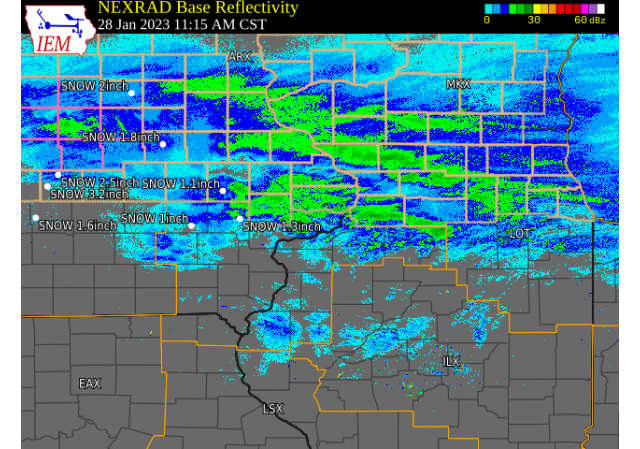
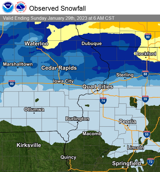
A storm system tracked east northeast across eastern IA, northwest IL, and northeast MO on Saturday bringing snow to portions of the region. Areas along and north of I-80 received the bulk of the snow from this event, with amounts over a half inch. The highest totals were north of highway 30 in Illinois, with amounts between 4 and 6 inches. In addition, light freezing rain/drizzle occurred during the evening and overnight hours across much of eastern IA and northwest IL creating a light glaze over the newly fallen snow and on elevated surfaces. NWS Official Totals Moline: 0.4"
|
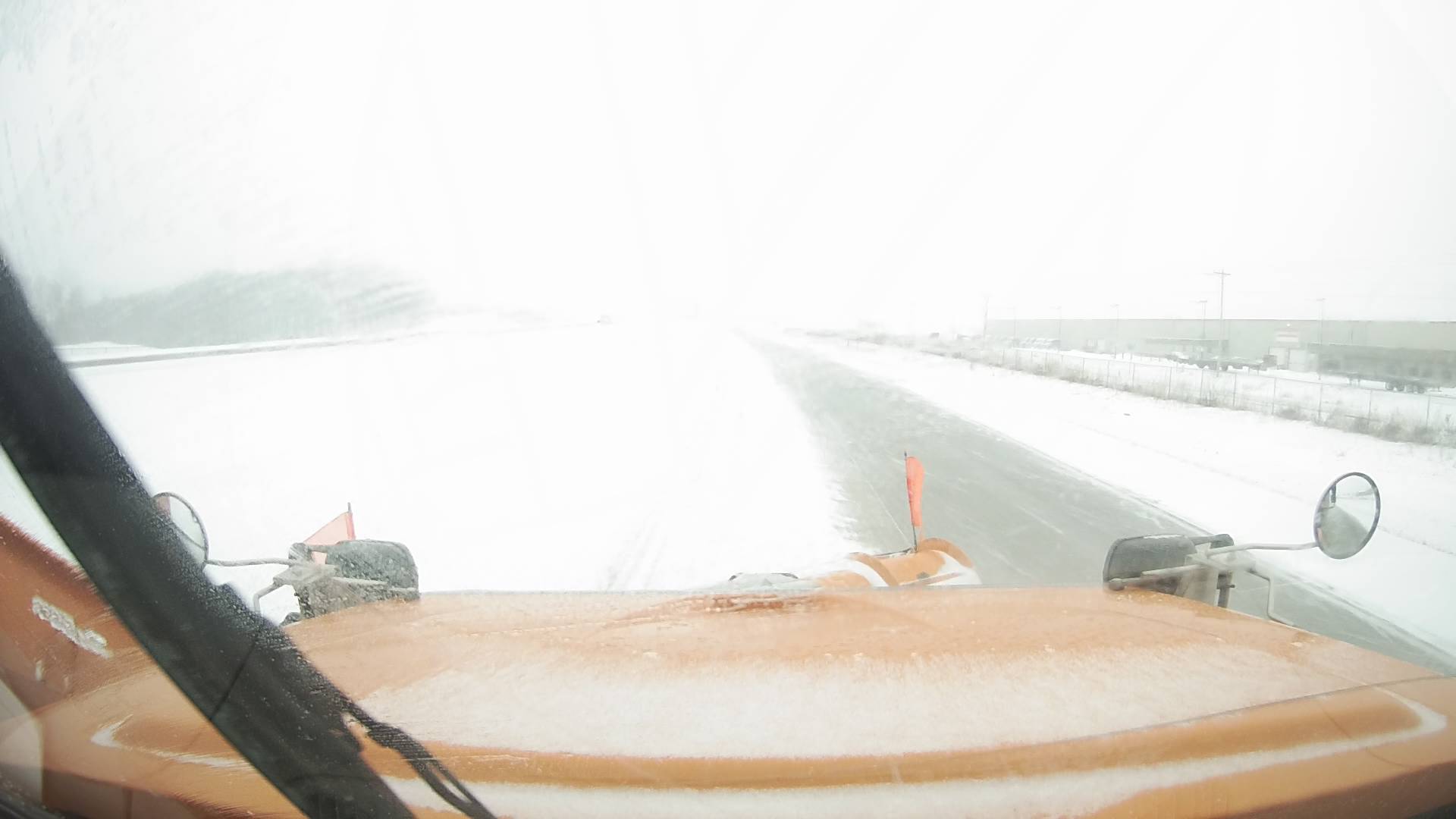 US 20 near Dubuque, IA Snowplow Cam - IA DOT |
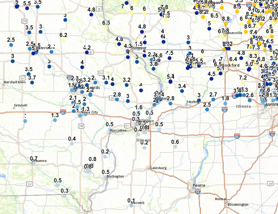
Preliminary Snow Maps
| Regional Snow Map (courtesy IEM) |
Local Snow Map |
 |
 |
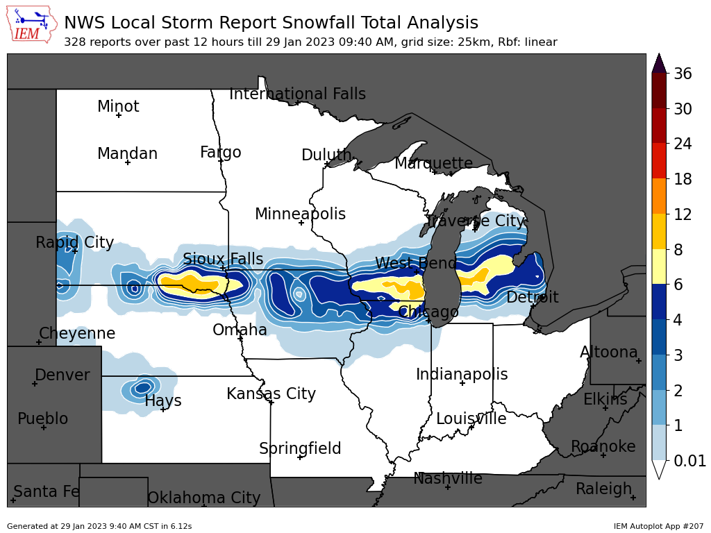
Storm Reports
| Storm Reports Map Courtesy IEM |
|
|
PRELIMINARY LOCAL STORM REPORT...SUMMARY
NATIONAL WEATHER SERVICE QUAD CITIES IA IL
932 AM CST SUN JAN 29 2023
..TIME... ...EVENT... ...CITY LOCATION... ...LAT.LON...
..DATE... ....MAG.... ..COUNTY LOCATION..ST.. ...SOURCE....
..REMARKS..
0920 PM SNOW 2 ENE HAZLETON 42.63N 91.86W
01/28/2023 M6.2 INCH BUCHANAN IA CO-OP OBSERVER
UPDATES THE PREVIOUS SNOW REPORT FROM 2 ENE
HAZLETON OF 5.1 INCHES. 2.8 SINCE 5 PM.
0925 PM SNOW DAVIS 42.42N 89.42W
01/28/2023 M6.0 INCH STEPHENSON IL TRAINED SPOTTER
UPDATED TOTAL.
1244 AM SNOW 3 SW WINNESHIEK 42.32N 89.57W
01/29/2023 M6.0 INCH STEPHENSON IL TRAINED SPOTTER
0500 PM SNOW 2 WNW FREEPORT 42.30N 89.66W
01/28/2023 M5.8 INCH STEPHENSON IL TRAINED SPOTTER
0625 PM SNOW RIDOTT 42.30N 89.48W
01/28/2023 M5.5 INCH STEPHENSON IL PUBLIC
1056 PM SNOW MOUNT CARROLL 42.09N 89.98W
01/28/2023 M5.4 INCH CARROLL IL TRAINED SPOTTER
0400 PM SNOW 2 SE SCIOTO MILLS 42.33N 89.64W
01/28/2023 E5.1 INCH STEPHENSON IL TRAINED SPOTTER
0455 PM SNOW FREEPORT 42.29N 89.63W
01/28/2023 M5.0 INCH STEPHENSON IL TRAINED SPOTTER
SNOW SO FAR. STILL LIGHT SNOW AT TIME OF
REPORT.
0718 AM SNOW RICKARDSVILLE 42.58N 90.88W
01/29/2023 E4.8 INCH DUBUQUE IA TRAINED SPOTTER
STORM TOTAL.
0800 AM SNOW 2 SSE SCHAPVILLE 42.37N 90.19W
01/29/2023 M4.6 INCH JO DAVIESS IL TRAINED SPOTTER
0615 PM SNOW 3 N STOCKTON 42.40N 90.00W
01/28/2023 M4.5 INCH JO DAVIESS IL CO-OP OBSERVER
0730 AM SNOW MOUNT CARROLL 42.10N 89.98W
01/29/2023 M4.5 INCH CARROLL IL CO-OP OBSERVER
CO-OP OBSERVER STATION MTCI2 MOUNT CARROLL.
0915 AM SNOW 1 NW CENTER GROVE 42.49N 90.73W
01/29/2023 M4.3 INCH DUBUQUE IA PUBLIC
STORM TOTAL.
0746 PM SNOW 2 WSW MARION 42.03N 91.62W
01/28/2023 M4.2 INCH LINN IA PUBLIC
0700 AM SNOW 1 SSE MANCHESTER 42.47N 91.45W
01/29/2023 M4.2 INCH DELAWARE IA CO-OP OBSERVER
CO-OP OBSERVER STATION MHRI4 MANCHESTER.
0432 PM SNOW CEDARVILLE 42.37N 89.64W
01/28/2023 M4.1 INCH STEPHENSON IL TRAINED SPOTTER
STILL SNOWING.
0412 PM SNOW WYOMING 42.06N 91.00W
01/28/2023 M4.0 INCH JONES IA TRAINED SPOTTER
0432 PM SNOW 1 E HIAWATHA 42.04N 91.67W
01/28/2023 E4.0 INCH LINN IA PUBLIC
0651 PM SNOW 1 NW GALENA 42.43N 90.44W
01/28/2023 M4.0 INCH JO DAVIESS IL TRAINED SPOTTER
1146 PM SNOW COGGON 42.28N 91.53W
01/28/2023 M4.0 INCH LINN IA TRAINED SPOTTER
1200 AM SNOW 1 NW DUBUQUE REGIONAL A 42.41N 90.73W
01/29/2023 M4.0 INCH DUBUQUE IA OFFICIAL NWS OBS
ADDITIONAL 0.4 TENTHS SINCE 6 PM, STORM
TOTAL.
0700 AM SNOW 2 WNW CHARLOTTE 41.98N 90.50W
01/29/2023 M4.0 INCH CLINTON IA COCORAHS
COCORAHS STATION IA-CN-17 CHARLOTTE 1.9 WNW.
0730 AM SNOW 3 ENE BOLTON 42.27N 89.68W
01/29/2023 M4.0 INCH STEPHENSON IL COCORAHS
COCORAHS STATION IL-SP-26 FREEPORT 2.9 WSW.
0700 AM SNOW HANOVER 42.26N 90.28W
01/29/2023 M3.8 INCH JO DAVIESS IL COCORAHS
COCORAHS STATION IL-JD-6 HANOVER 0.2 NW.
0630 AM SNOW ELIZABETH 42.32N 90.23W
01/29/2023 M3.7 INCH JO DAVIESS IL CO-OP OBSERVER
CO-OP OBSERVER STATION EZBI2 ELIZABETH.
0600 AM SNOW 2 NE CLINTON 41.86N 90.21W
01/29/2023 M3.5 INCH CLINTON IA COCORAHS
COCORAHS STATION IA-CN-22 CLINTON 1.7 NNW.
0700 AM SNOW MARION 42.04N 91.59W
01/29/2023 M3.5 INCH LINN IA COCORAHS
COCORAHS STATION IA-LN-59 MARION.
0517 PM SNOW FULTON 41.86N 90.16W
01/28/2023 M3.4 INCH WHITESIDE IL TRAINED SPOTTER
UPDATES PREVIOUS SNOW REPORT FROM FULTON F
1.5 INCHES.
0944 PM SNOW MILLEDGEVILLE 41.97N 89.78W
01/28/2023 M3.4 INCH CARROLL IL TRAINED SPOTTER
UPDATES PREVIOUS SNOW REPORT FROM
MILLEDGEVILLE. SNOW SO FAR, STILL SNOWING AT
TIME OF REPORT.
0245 PM SNOW 2 NE CLINTON 41.86N 90.21W
01/28/2023 M3.3 INCH CLINTON IA PUBLIC
0839 PM SNOW 1 NW CENTER GROVE 42.49N 90.73W
01/28/2023 M3.3 INCH DUBUQUE IA TRAINED SPOTTER
UPDATED SNOWFALL TOTAL.
0218 PM SNOW SPRINGVILLE 42.05N 91.45W
01/28/2023 M3.2 INCH LINN IA PUBLIC
0700 AM SNOW 1 W MAQUOKETA MUNICIPAL 42.05N 90.75W
01/29/2023 M3.2 INCH JACKSON IA CO-OP OBSERVER
CO-OP OBSERVER STATION MKTI4 MAQUOKETA.
0348 PM SNOW 3 SW CENTER JUNCTION 42.08N 91.11W
01/28/2023 M3.1 INCH JONES IA PUBLIC
0153 PM SNOW 2 W MARION 42.03N 91.62W
01/28/2023 M3.0 INCH LINN IA PUBLIC
0509 PM SNOW ORANGEVILLE 42.46N 89.64W
01/28/2023 M3.0 INCH STEPHENSON IL TRAINED SPOTTER
STILL SNOWING.
0511 PM SNOW 1 E CLINTON 41.84N 90.22W
01/28/2023 M3.0 INCH CLINTON IA TRAINED SPOTTER
0600 AM SNOW 2 NNW MOUNT AUBURN 42.29N 92.11W
01/29/2023 M3.0 INCH BENTON IA COCORAHS
COCORAHS STATION IA-BT-11 MOUNT AUBURN 2.2
NNW.
0700 AM SNOW 2 NE CALAMUS 41.84N 90.73W
01/29/2023 M3.0 INCH CLINTON IA COCORAHS
COCORAHS STATION IA-CN-2 CALAMUS 2.0 NE.
0720 AM SNOW 2 SW SAINT DONATUS 42.35N 90.57W
01/29/2023 E3.0 INCH JACKSON IA TRAINED SPOTTER
AVERAGE, STORM TOTAL.
0430 PM SNOW JESUP 42.48N 92.07W
01/28/2023 M2.9 INCH BUCHANAN IA PUBLIC
0329 PM SNOW LOWDEN 41.86N 90.92W
01/28/2023 M3.0 INCH CEDAR IA CO-OP OBSERVER
UPDATES PREVIOUS SNOW REPORT FROM LOWDEN OF
2.5 INCHES.
0802 PM SNOW 1 W MORRISON 41.81N 89.98W
01/28/2023 M2.8 INCH WHITESIDE IL TRAINED SPOTTER
UPDATES PREVIOUS SNOW REPORT FROM 1 W
MORRISON. STILL SNOWING.
0356 PM SNOW 1 NW FULTON 41.88N 90.18W
01/28/2023 E2.5 INCH CLINTON IA PUBLIC
0700 AM SNOW 2 ESE FAIRVIEW 42.08N 91.30W
01/29/2023 M2.4 INCH JONES IA CO-OP OBSERVER
CO-OP OBSERVER STATION AMOI4 ANAMOSA 3 SSW.
0321 PM SNOW 1 NW CENTER GROVE 42.49N 90.73W
01/28/2023 M2.3 INCH DUBUQUE IA TRAINED SPOTTER
0700 AM SNOW 1 SE ROBINS 42.07N 91.66W
01/29/2023 M2.3 INCH LINN IA COCORAHS
COCORAHS STATION IA-LN-53 ROBINS 0.8 SE.
0420 PM SNOW 2 SE GALENA TERRITORY 42.38N 90.31W
01/28/2023 M2.2 INCH JO DAVIESS IL TRAINED SPOTTER
SNOW SO FAR, STILL SNOWING.
0654 AM SNOW 1 N LISBON 41.93N 91.39W
01/29/2023 M2.2 INCH LINN IA TRAINED SPOTTER
0700 AM SNOW LISBON 41.92N 91.39W
01/29/2023 M2.2 INCH LINN IA COCORAHS
COCORAHS STATION IA-LN-56 LISBON 0.1 W.
0306 PM SNOW 1 W COU FALLS 41.82N 91.69W
01/28/2023 M2.1 INCH JOHNSON IA PUBLIC
0223 PM SNOW BERTRAM 41.96N 91.53W
01/28/2023 M2.0 INCH LINN IA TRAINED SPOTTER
NOT SNOWING AT THIS TIME. SECOND ROUND
EXPECTED LATER.
0300 PM SNOW LISBON 41.92N 91.39W
01/28/2023 M2.0 INCH LINN IA PUBLIC
0318 PM SNOW 2 NE CEDAR RAPIDS 41.99N 91.65W
01/28/2023 M2.0 INCH LINN IA PUBLIC
0521 PM SNOW 1 E CAMANCHE 41.79N 90.26W
01/28/2023 M2.0 INCH CLINTON IA CO-OP OBSERVER
0545 PM SNOW TIFFIN 41.71N 91.68W
01/28/2023 M2.0 INCH JOHNSON IA TRAINED SPOTTER
0700 AM SNOW SOLON 41.80N 91.49W
01/29/2023 M2.0 INCH JOHNSON IA COCORAHS
COCORAHS STATION IA-JH-1 SOLON 0.3 ESE.
0145 PM SNOW 2 W CEDAR RAPIDS 41.98N 91.71W
01/28/2023 M1.9 INCH LINN IA TRAINED SPOTTER
STORM TOTAL.
0241 PM SNOW 2 NNW NORTH LIBERTY 41.76N 91.62W
01/28/2023 M1.7 INCH JOHNSON IA TRAINED SPOTTER
UPDATES PREVIOUS SNOW REPORT FROM 2 NNW
NORTH LIBERTY OF 1.5.
0502 PM SNOW 3 NNE CEDAR RAPIDS 42.01N 91.66W
01/28/2023 M1.7 INCH LINN IA TRAINED SPOTTER
0700 AM SNOW PARK VIEW 41.69N 90.54W
01/29/2023 M1.6 INCH SCOTT IA COCORAHS
COCORAHS STATION IA-ST-3 PARK VIEW 0.2 WSW.
1116 AM SNOW 4 ENE IOWA CITY 41.67N 91.47W
01/28/2023 E1.3 INCH JOHNSON IA TRAINED SPOTTER
STILL SNOWING.
0615 PM SNOW 1 SW UNIVERSITY HEIGHTS 41.65N 91.57W
01/28/2023 M1.3 INCH JOHNSON IA TRAINED SPOTTER
0624 AM SNOW PARNELL 41.59N 92.01W
01/29/2023 M1.3 INCH IOWA IA TRAINED SPOTTER
0922 AM SNOW 1 WSW NEW LONDON 40.92N 91.43W
01/28/2023 E0.8 INCH HENRY IA TRAINED SPOTTER
SNOW THIS AM.
1005 AM SNOW NEW LONDON 40.92N 91.40W
01/28/2023 M0.8 INCH HENRY IA TRAINED SPOTTER
1222 PM SNOW 1 SSW COAL VALLEY 41.43N 90.45W
01/28/2023 M0.8 INCH ROCK ISLAND IL TRAINED SPOTTER
0700 AM SNOW 1 SW NEW LONDON 40.91N 91.43W
01/29/2023 M0.8 INCH HENRY IA COCORAHS
COCORAHS STATION IA-HY-1 NEW LONDON 1.5 SW.
0700 AM SNOW 2 SW YARMOUTH 41.01N 91.35W
01/29/2023 M0.8 INCH DES MOINES IA COCORAHS
COCORAHS STATION IA-DM-15 2 WSW YARMOUTH.
0700 AM SNOW 1 E KEWANEE 41.24N 89.90W
01/29/2023 M0.6 INCH HENRY IL CO-OP OBSERVER
CO-OP OBSERVER STATION KEWI2 KEWANEE 1 E.
0911 AM SNOW KEOSAUQUA 40.73N 91.96W
01/28/2023 E0.5 INCH VAN BUREN IA TRAINED SPOTTER
1023 AM SNOW 2 N BURLINGTON 40.84N 91.12W
01/28/2023 M0.5 INCH DES MOINES IA TRAINED SPOTTER
1200 AM SNOW DAVENPORT AIRPORT 41.61N 90.58W
01/29/2023 M0.5 INCH SCOTT IA OFFICIAL NWS OBS
ADDITIONAL 0.1 TENTH SINCE 6 PM, STORM
TOTAL.
0645 AM SNOW 2 NNE LE CLAIRE 41.62N 90.35W
01/29/2023 M0.5 INCH SCOTT IA COCORAHS
COCORAHS STATION IA-ST-1 LE CLAIRE 1.8 NNE.
0700 AM SNOW 4 NNE MUSCATINE 41.47N 91.05W
01/29/2023 M0.5 INCH MUSCATINE IA CO-OP OBSERVER
CO-OP OBSERVER STATION MSTI4 2 N MUSCATINE.
0700 AM SNOW 1 NNE MOLINE 41.49N 90.48W
01/29/2023 M0.5 INCH ROCK ISLAND IL COCORAHS
COCORAHS STATION IL-RI-13 MOLINE 0.7 NNE.
0730 AM SNOW 2 NW GENESEO 41.47N 90.18W
01/29/2023 M0.5 INCH HENRY IL COCORAHS
COCORAHS STATION IL-HY-8 GENESEO 2.0 NW.
1200 PM SNOW 3 SW QUAD CITY AIRPORT 41.40N 90.55W
01/28/2023 M0.4 INCH ROCK ISLAND IL OFFICIAL NWS OBS
SINCE 6 AM.
0700 AM SNOW 1 SW WASHINGTON 41.28N 91.71W
01/29/2023 M0.4 INCH WASHINGTON IA CO-OP OBSERVER
CO-OP OBSERVER STATION WSHI4 WASHINGTON 2
SSW.
0700 AM SNOW 2 SE COAL VALLEY 41.43N 90.42W
01/29/2023 M0.4 INCH HENRY IL COCORAHS
COCORAHS STATION IL-HY-5 COAL VALLEY 1.9 SE.
0900 AM SNOW 3 ENE CHARLIE HEATH MEM 40.59N 91.84W
01/28/2023 E0.3 INCH CLARK MO TRAINED SPOTTER
DELAYED REPORT.
0505 AM SNOW 1 SE DAVENPORT 41.54N 90.59W
01/29/2023 M0.3 INCH SCOTT IA COCORAHS
COCORAHS STATION IA-ST-37 DAVENPORT 0.9 WNW.
0700 AM SNOW 2 NNE NEW WINDSOR 41.23N 90.44W
01/29/2023 M0.2 INCH HENRY IL COCORAHS
COCORAHS STATION IL-HY-6 NEW WINDSOR 2.0 N.
0700 AM SNOW 3 ESE AMBER 41.11N 91.13W
01/29/2023 M0.2 INCH LOUISA IA COCORAHS
COCORAHS STATION IA-LS-5 WAPELLO 5.4 SE.
0905 AM SNOW 1 SE MACOMB 40.46N 90.67W
01/28/2023 M0.1 INCH MCDONOUGH IL TRAINED SPOTTER
LIGHT DUSTING.
0707 PM FREEZING RAIN PARK VIEW 41.69N 90.54W
01/28/2023 U0.00 INCH SCOTT IA NWS EMPLOYEE
REPORTED MIX OF SNOW, SLEET AND FREEZING
RAIN. A 330 PM MEASURED 1.3 INCHES OF SNOW.
0738 PM SLEET PARK VIEW 41.69N 90.54W
01/28/2023 M0.0 INCH SCOTT IA NWS EMPLOYEE
HAS TRANSITIONED TO A MIX OF SNOW AND SLEET.
0803 PM FREEZING RAIN 1 W MORRISON 41.81N 89.98W
01/28/2023 E0.00 INCH WHITESIDE IL TRAINED SPOTTER
0605 AM FREEZING RAIN 1 NNE MOLINE 41.49N 90.48W
01/29/2023 U0.00 INCH ROCK ISLAND IL NWS EMPLOYEE
LIGHT GLAZE ON ELEVATED SURFACES.
0730 AM FREEZING RAIN LOWDEN 41.86N 90.92W
01/29/2023 U0.00 INCH CEDAR IA CO-OP OBSERVER
LIGHT GLAZE ON SNOW AND TEMPERATURE SHELTER.
|
 |
Media use of NWS Web News Stories is encouraged! Please acknowledge the NWS as the source of any news information accessed from this site. |
|