Widespread, life-threatening considerable flash flooding is expected in south-central Texas through at least Friday. Catastrophic river flooding and rapid rises on small streams, arroyos, and typically dry washes are expected in the Texas Hill Country. Wildfire smoke is impacting air quality across much of the Great Lakes region into the Northeast U.S. with Air Quality Alerts in effect. Read More >
Overview
|
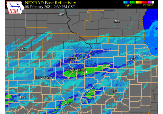
February 6, 2021 An area of light to moderate snow moved eastward across Iowa, Missouri, and Illinois Saturday, February 6, 2021. The snow was fluffy in nature and was easily drifted by northwest winds of 10 to 15 mph. Snowfall amounts were generally between 1 and 3 inches and roughly along and south of Highway 30. The higher amounts around 3 inches fell in southeast Iowa, northeast Missouri, and into parts of west central Illinois. Official National Weather Service Observations
|
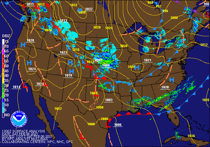 WPC - Surface Map and Radar Loop |
Snowfall Amounts
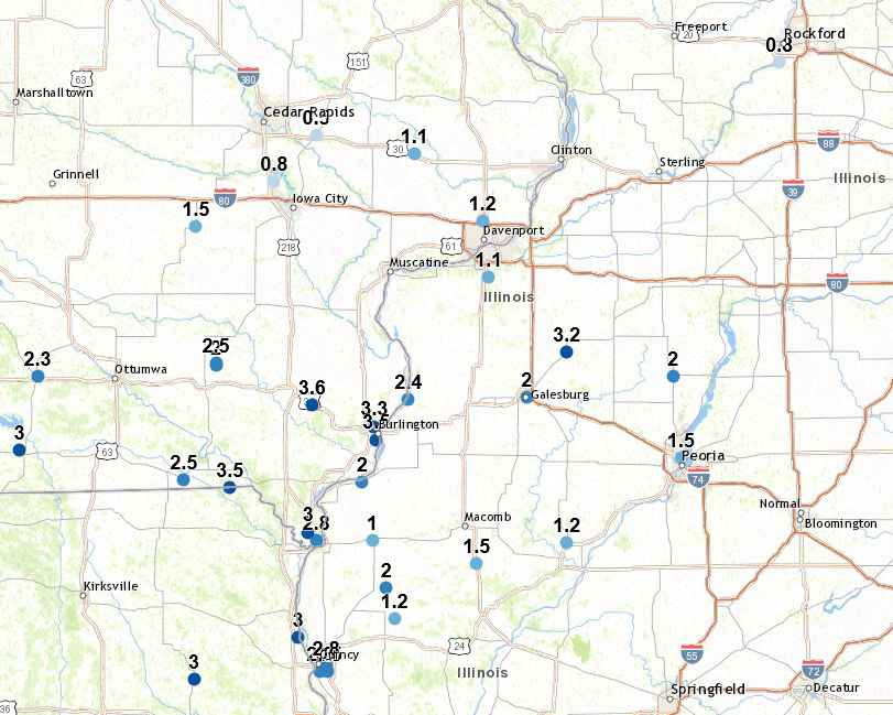 |
24 hour snow fall in inches,
for eastern Iowa, northwest and west central Illinois,
and northeast Missouri. Reported between Midnight and 9 AM,
Sunday February 07, 2021.
....IOWA.... Beaconsfield 1 NNE 3.5 Salem 1S 3.0 Keokuk LD19 3.0 Allerton 2 S 2.5 Donnellson 2.4 Wapello 5.4 SE 2.3 Muscatine 2.1 N 1.8 NWS Johnston* 5 NNW 1.8 Washington 1.5 Parnell 0.1 SSW 1.5 Davenport Arpt 1.2 Muscatine 2N 1.0 Davenport 0.9 WNW 1.0 Bettendorf 1.6 W 1.0 Solon 0.3 ESE 1.0 Wellman 4.0 E 0.8 Perry 0 W 0.8 Park View 0.2 WSW 0.7 Iowa City 0.5 Charlotte 1.9 WNW 0.5 North Liberty 0.7 SSW 0.5 Toledo 3 N 0.5 Amana 4.7 W 0.5 Williamsburg 0.5 West Liberty 0.7 NNW 0.5 Anamosa 3 SSW 0.2 Boone 1 SSW 0.2 Stanley 0.0 Maquoketa 0.0 Central City 6.7 W 0.0 Dubuque Arpt 0.0 Strawberry Point 0.0 Elkader 6SSW 0.0 Mason City 1 NNE 0.0 Dubuque LD11 0.0 Tripoli 0 N 0.0 Vinton 0.0 Fayette 1 NW 0.0 Waterloo ASOS 0.0 Hampton 1 N 0.0 Guttenberg Dam 10 0.0 ....ILLINOIS.... Kewanee 1 E 3.2 Aledo 2.0 La Harpe 2.0 Galesburg 2.0 Gladstone LD18 2.0 Macomb 2.0 Princeton 1.1 SE 1.5 Princeton 1.5 Moline 0.7 NNE 1.2 Colchester 3.5 NE 1.2 Geneseo 2.0 NW 1.1 Quad City Arpt 1.1 Minonk 1.0 Coal Valley 1.9 SE 1.0 Romeoville 0.9 Rockford ASOS 0.8 Ogden 0.8 Tuscola 0.8 Ill. City LD16 3 WNW 0.8 Mundelein 0.7 Steward 0.7 St Anne 0.7 Coal Valley 2.6 E 0.6 Windsor 0.5 Freeport 1.7 NW 0.3 Freeport 2.0 NW 0.2 Prairie City 2S 0.1 Paw Paw 1 E 0.0 Elizabeth 0.0 Winslow 4.3 ESE 0.0 Davis 0.5 N 0.0 ....MISSOURI.... Memphis 1.0 Columbia 0.6 |
Storm Reports
February 6 Storm Reports
Courtesy IEM
|
|
PRELIMINARY LOCAL STORM REPORT...SUMMARY
NATIONAL WEATHER SERVICE QUAD CITIES IA IL
849 AM CST SUN FEB 7 2021

..TIME...   ...EVENT...      ...CITY LOCATION...     ...LAT.LON...
..DATE...   ....MAG....      ..COUNTY LOCATION..ST.. ...SOURCE....
            ..REMARKS..

0415 PM     SNOW             1 WSW NEW LONDON        40.92N 91.43W
02/06/2021  M3.6 INCH        HENRY              IA   TRAINED SPOTTER


0630 PM     SNOW             3 ENE CHARLIE HEATH MEM 40.61N 91.84W
02/06/2021  M3.5 INCH        CLARK              MO   TRAINED SPOTTER

            UPDATED. EVENT TOTAL.

0730 PM     SNOW             1 ENE BURLINGTON REGION 40.79N 91.11W
02/06/2021  M3.5 INCH        DES MOINES         IA   TRAINED SPOTTER


0700 AM     SNOW             1 E KEWANEE             41.24N 89.90W
02/07/2021  M3.2 INCH        HENRY              IL   CO-OP OBSERVER

            CO-OP OBSERVER STATION KEWI2 KEWANEE 1 E.

0800 PM     SNOW             OQUAWKA                 40.94N 90.95W
02/06/2021  M3.1 INCH        HENDERSON          IL   TRAINED SPOTTER

            UPDATE. TOTAL.

0530 PM     SNOW             1 SSW MOOAR             40.44N 91.45W
02/06/2021  M3.0 INCH        LEE                IA   TRAINED SPOTTER


0912 PM     SNOW             4 NNE CROTON            40.63N 91.66W
02/06/2021  M3.0 INCH        LEE                IA   TRAINED SPOTTER


0700 AM     SNOW             1 S SALEM               40.84N 91.62W
02/07/2021  M3.0 INCH        HENRY              IA   CO-OP OBSERVER

            CO-OP OBSERVER STATION SLHI4 SALEM 1 S.

0616 PM     SNOW             KEOKUK                  40.41N 91.41W
02/06/2021  M2.8 INCH        LEE                IA   TRAINED SPOTTER

            STILL LIGHTLY SNOWING.

0600 PM     SNOW             CANTRIL                 40.64N 92.07W
02/06/2021  M2.5 INCH        VAN BUREN          IA   TRAINED SPOTTER


0920 PM     SNOW             GALVA                   41.17N 90.04W
02/06/2021  M2.5 INCH        HENRY              IL   PUBLIC


0700 AM     SNOW             DONNELLSON              40.65N 91.56W
02/07/2021  M2.4 INCH        LEE                IA   CO-OP OBSERVER

            CO-OP OBSERVER STATION DNNI4 DONNELLSON.

0700 AM     SNOW             3 ESE AMBER             41.11N 91.13W
02/07/2021  M2.3 INCH        LOUISA             IA   COCORAHS

            COCORAHS STATION IA-LS-5 WAPELLO 5.4 SE.

0611 PM     SNOW             2 NE COLUSA             40.59N 91.15W
02/06/2021  M2.0 INCH        HANCOCK            IL   TRAINED SPOTTER


0617 PM     SNOW             BOWEN                   40.23N 91.06W
02/06/2021  M2.0 INCH        HANCOCK            IL   PUBLIC


0600 AM     SNOW             7 S KINGSTON            40.88N 91.03W
02/07/2021  M2.0 INCH        DES MOINES         IA   MESONET

            MESONET STATION GLDI2 3.6 N LONE TREE.

0700 AM     SNOW             LA HARPE                40.58N 90.97W
02/07/2021  M2.0 INCH        HANCOCK            IL   CO-OP OBSERVER

            CO-OP OBSERVER STATION LAHI2 LA HARPE.

0700 AM     SNOW             ALEDO                   41.20N 90.75W
02/07/2021  M2.0 INCH        MERCER             IL   CO-OP OBSERVER

            CO-OP OBSERVER STATION ALEI2 ALEDO.

0700 AM     SNOW             1 NE MACOMB             40.48N 90.67W
02/07/2021  M2.0 INCH        MCDONOUGH          IL   CO-OP OBSERVER

            CO-OP OBSERVER STATION MQBI2 MACOMB.

0500 PM     SNOW             1 W HENNEPIN            41.25N 89.34W
02/06/2021  M1.9 INCH        PUTNAM             IL   CO-OP OBSERVER

            CO-OP OBSERVER STATION HNPI2 HENNEPIN.

0640 PM     SNOW             INDUSTRY                40.32N 90.61W
02/06/2021  M1.5 INCH        MCDONOUGH          IL   TRAINED SPOTTER


0600 AM     SNOW             PARNELL                 41.58N 92.01W
02/07/2021  M1.5 INCH        IOWA               IA   COCORAHS

            COCORAHS STATION IA-IA-13 PARNELL 0.1 SSW.

0700 AM     SNOW             PRINCETON               41.38N 89.46W
02/07/2021  M1.5 INCH        BUREAU             IL   CO-OP OBSERVER

            CO-OP OBSERVER STATION PTNI2 PRINCETON.

0700 AM     SNOW             1 SW WASHINGTON         41.28N 91.71W
02/07/2021  M1.5 INCH        WASHINGTON         IA   CO-OP OBSERVER

            CO-OP OBSERVER STATION WSHI4 WASHINGTON 2
            SSW.

0800 PM     SNOW             1 E CAMANCHE            41.79N 90.26W
02/06/2021  M1.4 INCH        CLINTON            IA   CO-OP OBSERVER

            OFFICIAL NWS OBSERVATION FOR CLINTON.

1200 AM     SNOW             GENESEO                 41.45N 90.15W
02/07/2021  M1.3 INCH        HENRY              IL   CO-OP OBSERVER

            CO-OP OBSERVER STATION GINI2 GENESEO.

0603 AM     SNOW             1 S COAL VALLEY         41.43N 90.45W
02/07/2021  M1.3 INCH        ROCK ISLAND        IL   TRAINED SPOTTER


0600 PM     SNOW             DAVENPORT AIRPORT       41.61N 90.58W
02/06/2021  M1.2 INCH        SCOTT              IA   OFFICIAL NWS OBS


0600 AM     SNOW             1 NNE MOLINE            41.49N 90.48W
02/07/2021  M1.2 INCH        ROCK ISLAND        IL   COCORAHS

            COCORAHS STATION IL-RI-13 MOLINE 0.7 NNE.

0700 AM     SNOW             3 W MACOMB              40.46N 90.75W
02/07/2021  M1.2 INCH        MCDONOUGH          IL   COCORAHS

            COCORAHS STATION IL-MCD-7 COLCHESTER 3.5 NE.

0520 PM     SNOW             LOWDEN                  41.86N 90.92W
02/06/2021  M1.1 INCH        CEDAR              IA   CO-OP OBSERVER


0600 PM     SNOW             3 SW QUAD CITY AIRPORT  41.40N 90.55W
02/06/2021  M1.1 INCH        ROCK ISLAND        IL   OFFICIAL NWS OBS


0730 AM     SNOW             2 NW GENESEO            41.47N 90.18W
02/07/2021  M1.1 INCH        HENRY              IL   COCORAHS

            COCORAHS STATION IL-HY-8 GENESEO 2.0 NW.

0610 PM     SNOW             CARTHAGE                40.41N 91.13W
02/06/2021  M1.0 INCH        HANCOCK            IL   TRAINED SPOTTER


0805 PM     SNOW             CAMBRIDGE               41.30N 90.20W
02/06/2021  M1.0 INCH        HENRY              IL   TRAINED SPOTTER


1200 AM     SNOW             3 NNE ROCK ISLAND       41.52N 90.57W
02/07/2021  M1.0 INCH        ROCK ISLAND        IL   MESONET

            MESONET STATION RCKI2 2.9 N ROCK ISLAND.

0700 AM     SNOW             SOLON                   41.80N 91.49W
02/07/2021  M1.0 INCH        JOHNSON            IA   COCORAHS

            COCORAHS STATION IA-JH-1 SOLON 0.3 ESE.

0700 AM     SNOW             4 NNE MUSCATINE         41.47N 91.05W
02/07/2021  M1.0 INCH        MUSCATINE          IA   CO-OP OBSERVER

            CO-OP OBSERVER STATION MSTI4 2 N MUSCATINE.

0700 AM     SNOW             1 SE DAVENPORT          41.54N 90.59W
02/07/2021  M1.0 INCH        SCOTT              IA   COCORAHS

            COCORAHS STATION IA-ST-37 DAVENPORT 0.9 WNW.

0300 PM     SNOW             2 NNW NORTH LIBERTY     41.76N 91.62W
02/06/2021  M0.8 INCH        JOHNSON            IA   TRAINED SPOTTER

            SO FAR.

0700 AM     SNOW             3 W RICHMOND            41.46N 91.76W
02/07/2021  M0.8 INCH        WASHINGTON         IA   COCORAHS

            COCORAHS STATION IA-WS-7 WELLMAN 4.0 E.

0700 AM     SNOW             PARK VIEW               41.69N 90.54W
02/07/2021  M0.7 INCH        SCOTT              IA   COCORAHS

            COCORAHS STATION IA-ST-3 PARK VIEW 0.2 WSW.

0730 PM     SNOW             1 ENE MOUNT VERNON      41.93N 91.41W
02/06/2021  M0.5 INCH        LINN               IA   TRAINED SPOTTER


0700 AM     SNOW             1 NNE WEST AMANA        41.81N 91.97W
02/07/2021  M0.5 INCH        IOWA               IA   COCORAHS

            COCORAHS STATION IA-IA-6 AMANA 4.7 W.

0700 AM     SNOW             2 WNW CHARLOTTE         41.98N 90.50W
02/07/2021  M0.5 INCH        CLINTON            IA   COCORAHS

            COCORAHS STATION IA-CN-17 CHARLOTTE 1.9 WNW.

0800 AM     SNOW             1 SSW NORTH LIBERTY     41.73N 91.62W
02/07/2021  M0.5 INCH        JOHNSON            IA   COCORAHS

            COCORAHS STATION IA-JH-27 NORTH LIBERTY 0.7
            SSW.

0500 PM     SNOW             1 N MARION              42.05N 91.59W
02/06/2021  M0.4 INCH        LINN               IA   CO-OP OBSERVER

            CO-OP OBSERVER STATION CRPI4 CEDAR RAPIDS
            NO. 1.

0700 AM     SNOW             1 SE ROBINS             42.07N 91.66W
02/07/2021  M0.4 INCH        LINN               IA   COCORAHS

            COCORAHS STATION IA-LN-53 ROBINS 0.8 SE.

0700 AM     SNOW             2 ESE FAIRVIEW          42.08N 91.30W
02/07/2021  M0.2 INCH        JONES              IA   CO-OP OBSERVER

            CO-OP OBSERVER STATION AMOI4 ANAMOSA 3 SSW.
|
|
|
 |
Media use of NWS Web News Stories is encouraged! Please acknowledge the NWS as the source of any news information accessed from this site. |
|