
Dangerous and extreme heat will remain across portions of the central U.S. this week, persisting across the mid to lower Mississippi Valley, Gulf Coast, southern Plains and portions of Texas. A heat wave over the Southwest U.S. will peak this weekend. Heavy to excessive rainfall may produce flash flooding from the Delmarva Peninsula north into the Hudson Valley today and tonight. Read More >
Overview
|
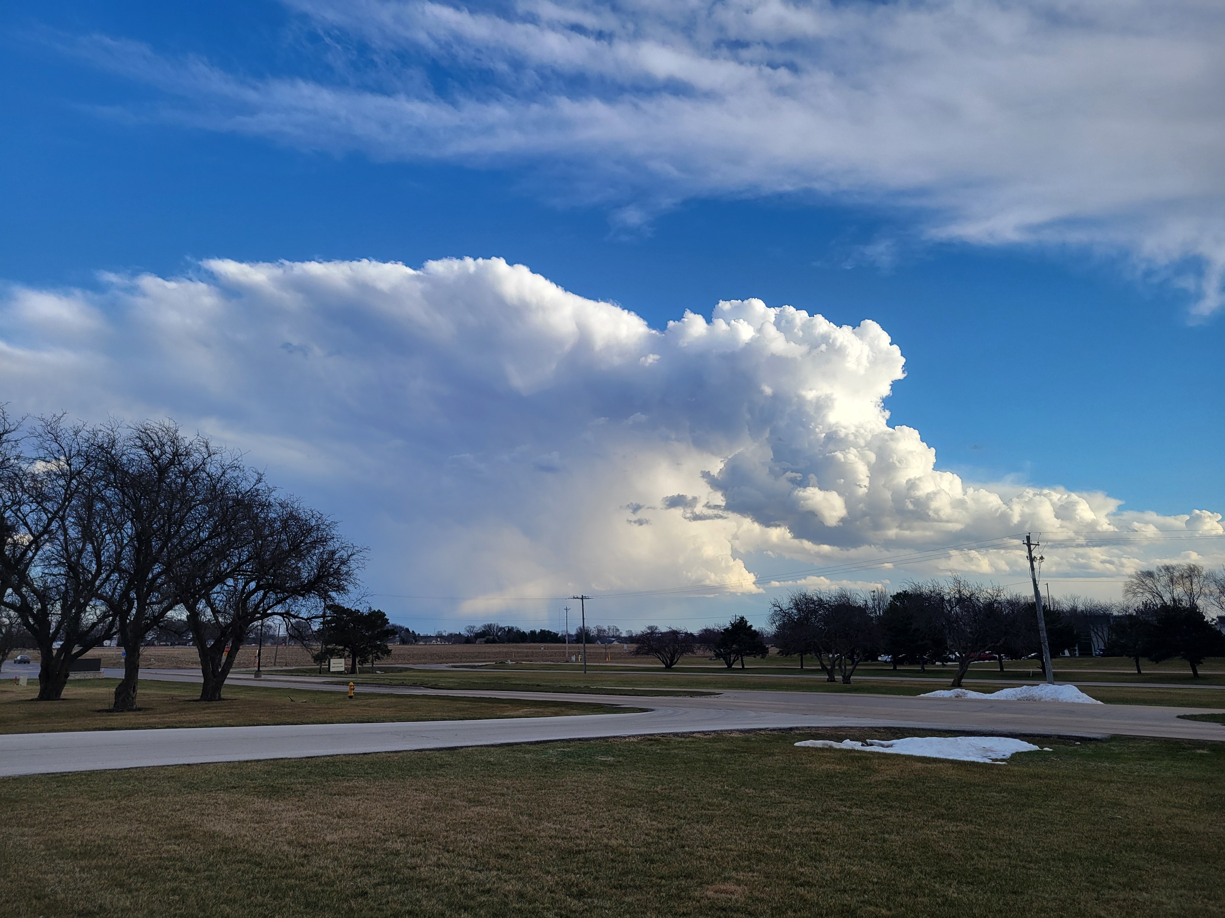
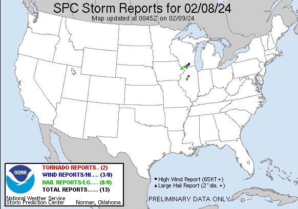
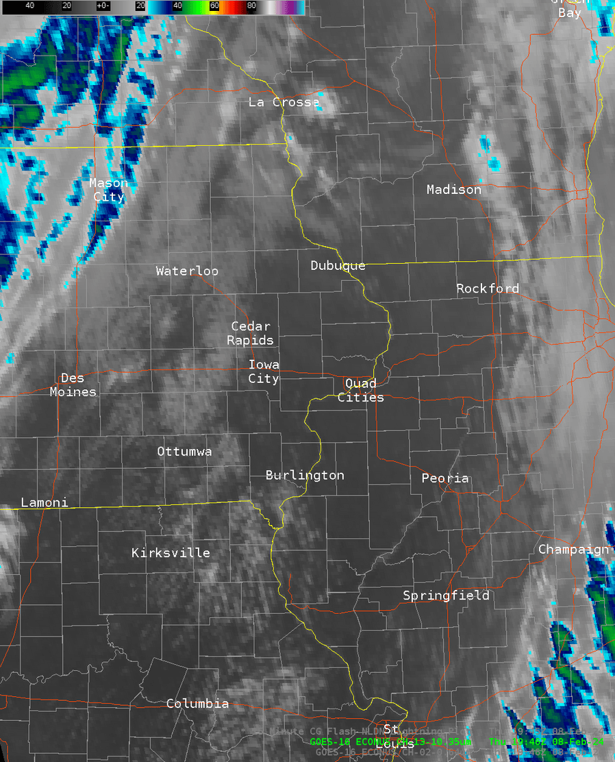
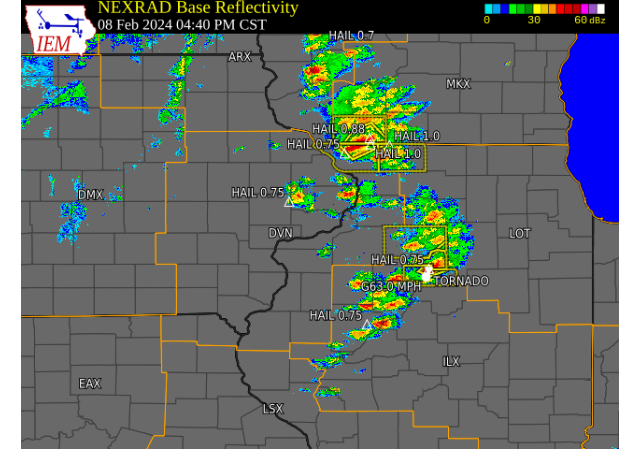
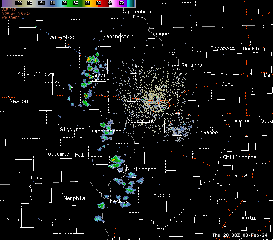
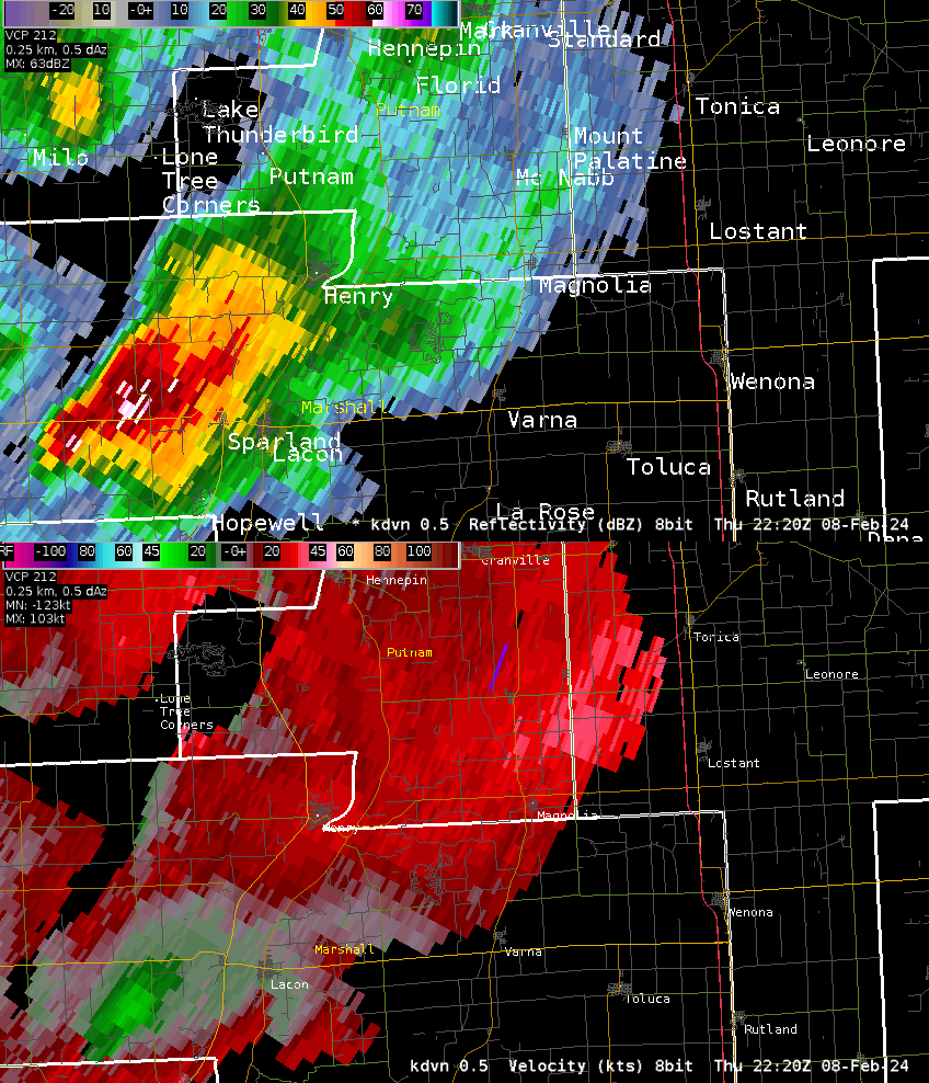
Several thunderstorms developed across much of eastern Iowa and northwest Illinois on the afternoon and early evening of February 8, 2024. Many of these storms had pea to dime size hail. The strongest storms occurred in Jackson County, IA and Jo Daviess, Stephenson, and Putnam counties in IL. Quarter to ping pong ball size fell with the storms in Jackson, Jo Daviess, and Stephenson counties, with the larger hailstones reported near Freeport, IL. A brief tornado developed just south of the Quad Cities County Warning Area in Marshall county and moved into Putnam county. A stronger tornado developed in Wisconsin (NWS Milwaukee recap). In addition to the storms, record warmth occurred with widespread highs in the 60s and strong gradient winds gusting 35-50 mph. |
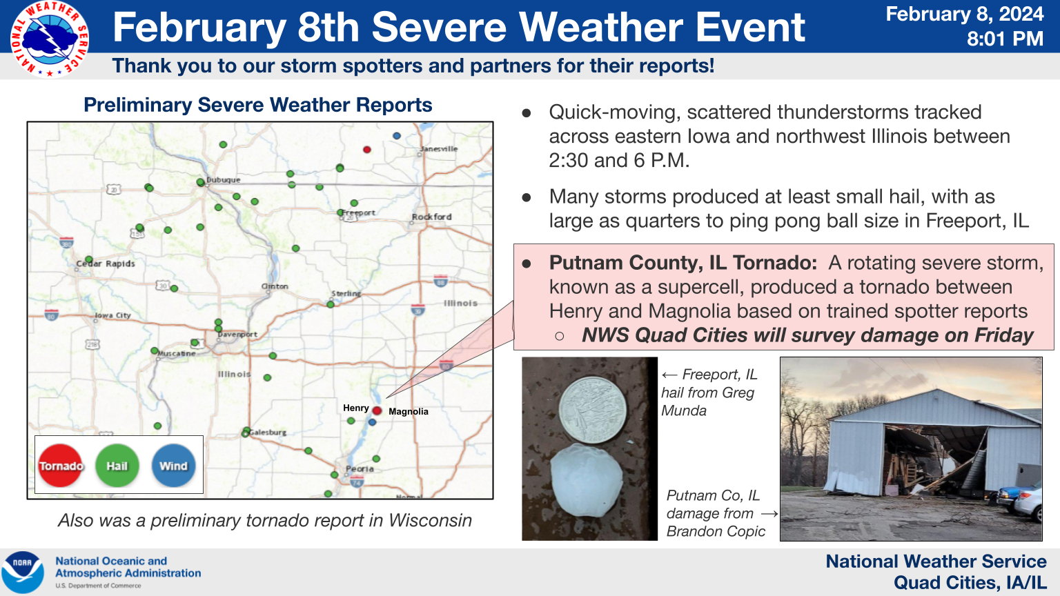 Event Infographic (Link to Image) |
 |
 |
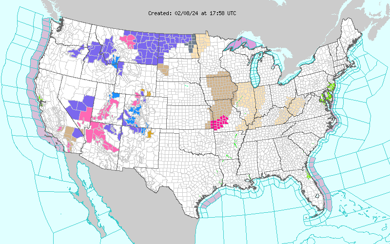 |
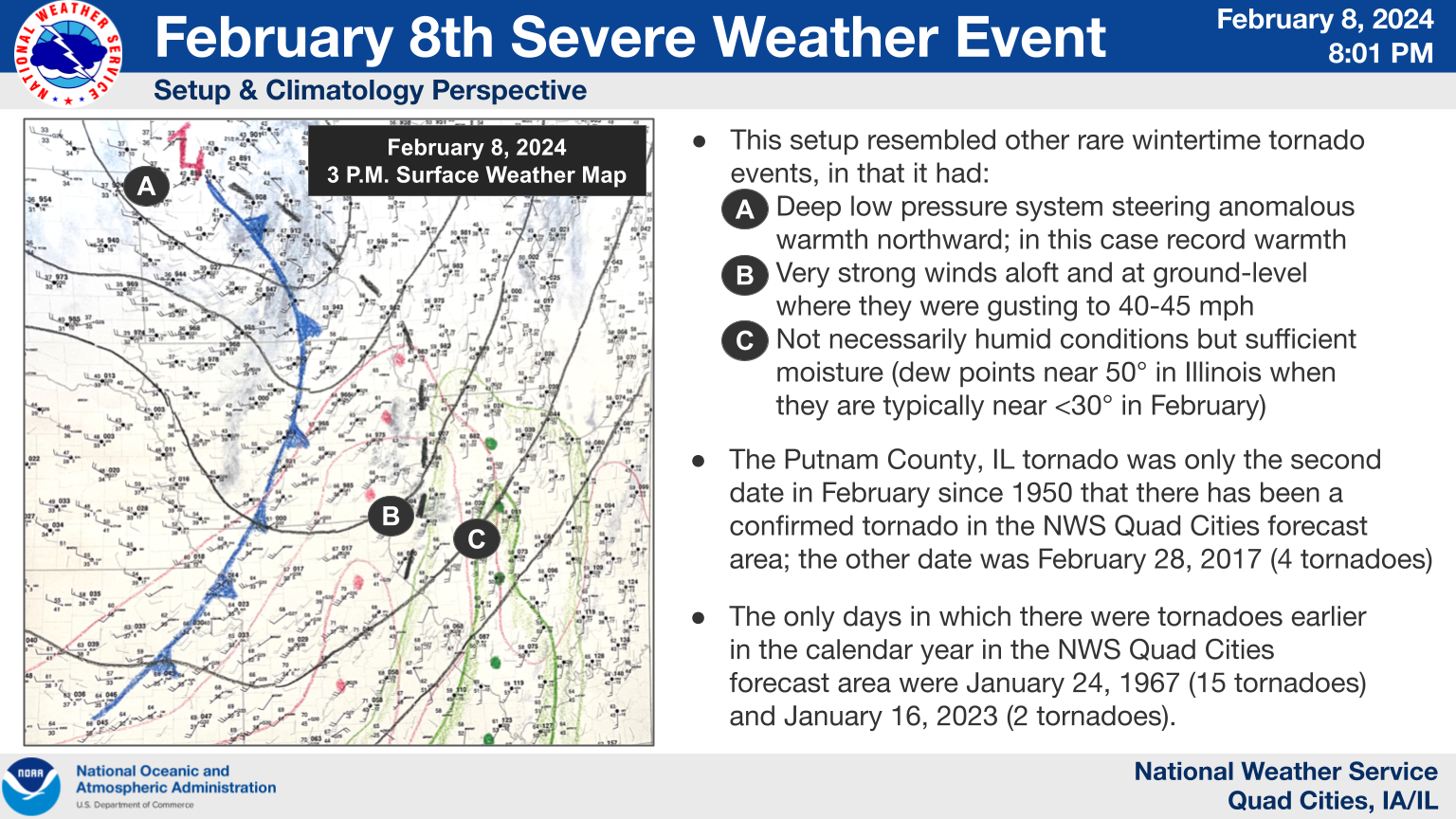
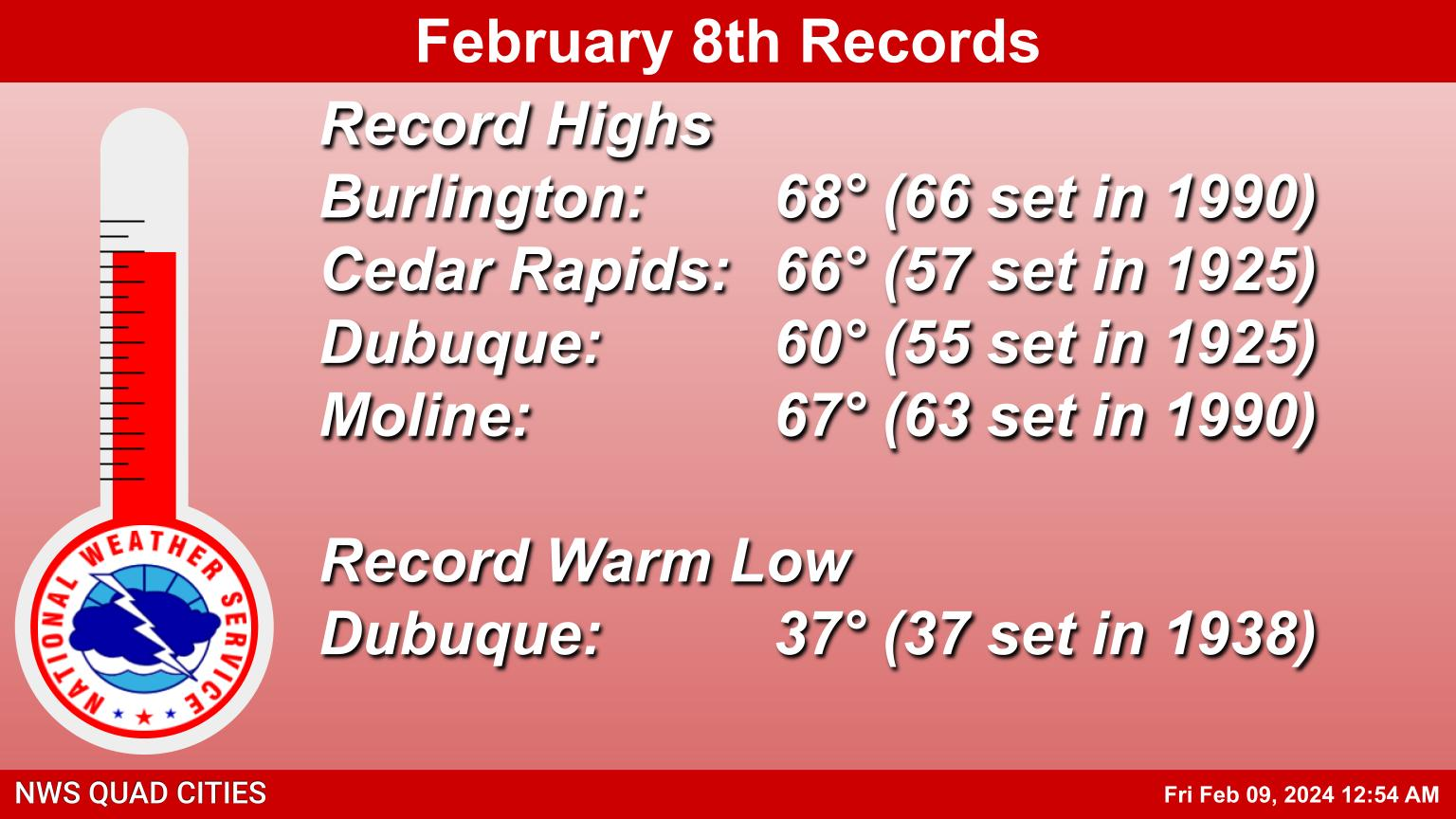
| Severe Weather Setup Infographic (Link to Image) | Record Highs / Warm Lows February 8th | Wind Advisory Area (brown) |
Tornadoes:
|
Tornado - 2 SE Henry IL
Track Map 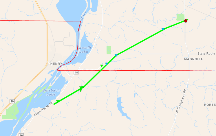 
|
||||||||||||||||
The Enhanced Fujita (EF) Scale classifies tornadoes into the following categories:
| EF0 Weak 65-85 mph |
EF1 Moderate 86-110 mph |
EF2 Significant 111-135 mph |
EF3 Severe 136-165 mph |
EF4 Extreme 166-200 mph |
EF5 Catastrophic 200+ mph |
 |
|||||
Wind & Hail:
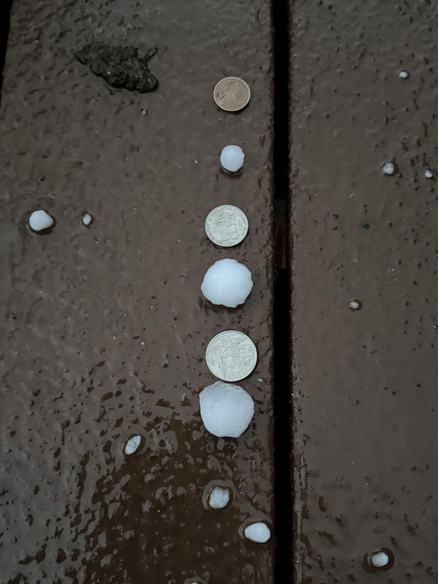
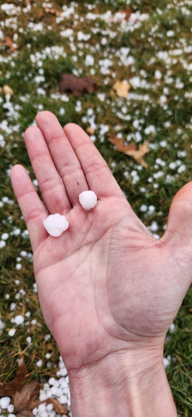
Strong south winds gusting between 35 and 50 mph were common during the day Thursday. These winds brought very warm temperatures and unusually high dewpoints into the region which supported thunderstorm development. Most storms that occurred Thursday afternoon had pea to dime size hail. The strongest cells tracked across Jackson county in IA and Jo Daviess and Stephenson counties in IL where quarter to ping pong ball size hail fell.
Wind
...Highest Wind Reports Past 24 Hours...

Observations are collected from a variety of sources with varying
equipment and exposures. Not all data listed are considered official.

Location                     Speed     Time/Date       Provider
Burlington Arpt              49 MPH    0359 PM 02/08   ASOS
Iowa City Arpt               49 MPH    0101 PM 02/08   ASOS
Cedar Rapids Arpt            48 MPH    0154 PM 02/08   ASOS
Mount Pleasant Arpt          48 MPH    0335 PM 02/08   AWOS
Olin                         47 MPH    0125 PM 02/08   CWOP
University Heights           46 MPH    0210 PM 02/08   MESOWEST
Davenport Arpt               46 MPH    0325 PM 02/08   ASOS
Fairfield Arpt               45 MPH    0235 PM 02/08   AWOS
Muscatine Arpt               45 MPH    0235 PM 02/08   AWOS
Washington Arpt              44 MPH    0215 PM 02/08   AWOS
Quad City Intl Arpt          44 MPH    0258 PM 02/08   ASOS
Anamosa                      44 MPH    0640 PM 02/08   MESOWEST
Cantril                      43 MPH    0140 PM 02/08   MESOWEST
Victor                       43 MPH    0140 PM 02/08   MESOWEST
New London                   42 MPH    0400 PM 02/08   CWOP
Fairfax                      42 MPH    0135 PM 02/08   DAVIS
Dubuque                      41 MPH    0919 PM 02/08   CWOP
Dubuque Arpt                 41 MPH    0244 PM 02/08   ASOS
Keokuk Arpt                  41 MPH    0335 PM 02/08   AWOS
Eldridge                     40 MPH    0905 PM 02/08   CWOP
Mount Pleasant               40 MPH    0340 PM 02/08   MESOWEST
Sigourney                    40 MPH    0140 PM 02/08   MESOWEST
Hail / Cloud Photos
 |
 |
 |
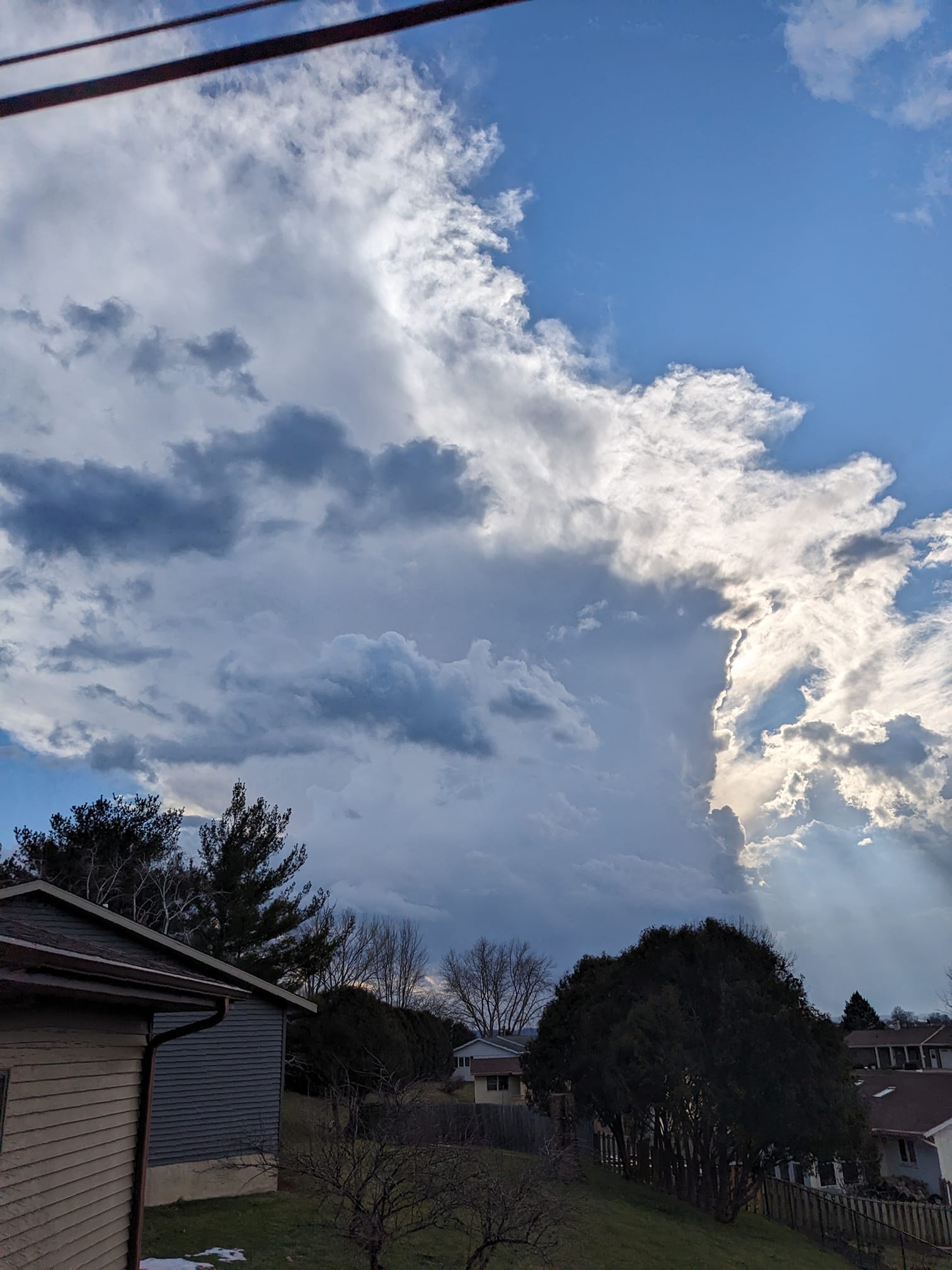 |
| Freeport, IL Image: Greg Munda |
Dyersville, IA Image: Jamie Unsen |
Davenport, IA NWS Office Image: Andy Ervin |
Dubuque, IA Image: Mike Silvis |
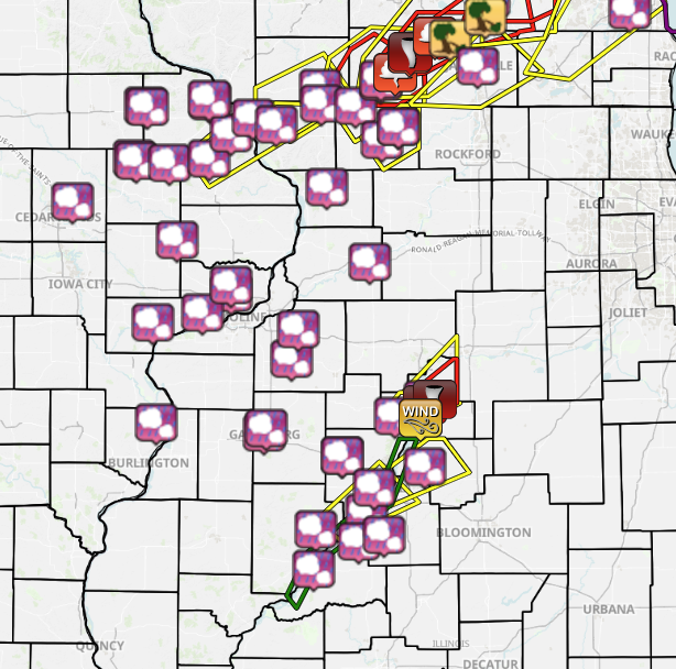
Storm Reports
| Interactive Storm Report Link | SPC Severe Weather Event: February 8, 2024 |
 |
 |
Preliminary Local Storm Report...Summary
National Weather Service Quad Cities IA IL
854 PM CST Thu Feb 8 2024

..TIME...   ...EVENT...      ...CITY LOCATION...     ...LAT.LON...
..DATE...   ....MAG....      ..COUNTY LOCATION..ST.. ...SOURCE....
            ..REMARKS..

0543 PM     Hail             1 WNW Whiteside County  41.76N 89.71W
02/08/2024  E0.25 inch       Whiteside          IL   Public


0540 PM     Hail             1 N Dakota              42.39N 89.53W
02/08/2024  E1.00 inch       Stephenson         IL   Trained Spotter

            Dime to quarter size hail.

0534 PM     Hail             2 ESE Scioto Mills      42.33N 89.63W
02/08/2024  E1.50 inch       Stephenson         IL   Trained Spotter


0501 PM     Hail             1 NNW Mount Carroll     42.11N 89.98W
02/08/2024  E0.25 inch       Carroll            IL   Trained Spotter


0453 PM     Hail             Winslow                 42.49N 89.80W
02/08/2024  M1.00 inch       Stephenson         IL   Public

            Time estimated based on radar.

0447 PM     Hail             1 W Warren              42.50N 90.01W
02/08/2024  E1.00 inch       Jo Daviess         IL   Trained Spotter


0445 PM     Tornado          5 W Magnolia            41.11N 89.30W
02/08/2024                   Putnam             IL   Emergency Mngr

            A semi truck was overturned with damage to
            at least one outbuilding, as well as to
            multiple large trees, at this location.
            Multiple trained spotter visual reports and
            video of a tornado. Time estimated based on
            video and radar. Unknown path length, width,
            and maximum winds at this time.

0430 PM     Hail             Lowden                  41.86N 90.92W
02/08/2024  E0.75 inch       Cedar              IA   CO-OP Observer

            Covered ground in small hail, with a few
            flat disks that were dime diameter.

0426 PM     Hail             2 E Galena Territory    42.40N 90.30W
02/08/2024  E0.75 inch       Jo Daviess         IL   Public

            Report from mPING: Dime (0.75 in.).

0413 PM     Hail             2 E Asbury              42.52N 90.72W
02/08/2024  E0.88 inch       Dubuque            IA   Public

            Nickel estimate a few larger possible.

0407 PM     Hail             1 NW Galena             42.43N 90.44W
02/08/2024  M0.25 inch       Jo Daviess         IL   Public


0407 PM     Hail             1 NNW Eldridge          41.65N 90.58W
02/08/2024  E0.25 inch       Scott              IA   NWS Employee


0400 PM     Hail             2 WSW Saint Donatus     42.36N 90.58W
02/08/2024  E0.70 inch       Jackson            IA   Trained Spotter


0400 PM     Hail             Davenport NWS Office    41.61N 90.58W
02/08/2024  E0.50 inch       Scott              IA   Official NWS Obs


0400 PM     Hail             1 NNE Blue Grass        41.52N 90.76W
02/08/2024  E0.88 inch       Scott              IA   Public

            Relayed by media.

0356 PM     Hail             2 WNW Otter Creek       42.24N 90.72W
02/08/2024  M1.25 inch       Jackson            IA   Trained Spotter

            Time estimated from radar.

0356 PM     Hail             1 WNW Dubuque           42.51N 90.71W
02/08/2024  E0.25 inch       Dubuque            IA   Trained Spotter


0355 PM     Hail             1 SSW Geneseo           41.44N 90.16W
02/08/2024  E0.25 inch       Henry              IL   Trained Spotter


0350 PM     Hail             1 SSW Cambridge         41.30N 90.20W
02/08/2024  M0.25 inch       Henry              IL   Trained Spotter


0331 PM     Hail             1 SSE Temple Hill       42.22N 90.97W
02/08/2024  E0.75 inch       Jones              IA   Public

            Report from mPING: Dime (0.75 in.).

0330 PM     Hail             3 N Muscatine           41.47N 91.07W
02/08/2024  E0.50 inch       Muscatine          IA   Trained Spotter


0321 PM     Hail             1 SSE Monticello        42.23N 91.18W
02/08/2024  E0.25 inch       Jones              IA   Trained Spotter


0318 PM     Hail             Dyersville              42.48N 91.11W
02/08/2024  E0.70 inch       Dubuque            IA   Emergency Mngr

            Relayed by Emergency Management.

0317 PM     Hail             Dyersville              42.49N 91.12W
02/08/2024  E0.70 inch       Dubuque            IA   Broadcast Media

            Photo relayed by media.

0315 PM     Hail             Monticello              42.24N 91.19W
02/08/2024  E0.25 inch       Jones              IA   Law Enforcement


0300 PM     Hail             1 NNW Kingston          41.00N 91.05W
02/08/2024  E0.25 inch       Des Moines         IA   Trained Spotter


0245 PM     Hail             1 NE Marion             42.04N 91.58W
02/08/2024  E0.25 inch       Linn               IA   Trained Spotter
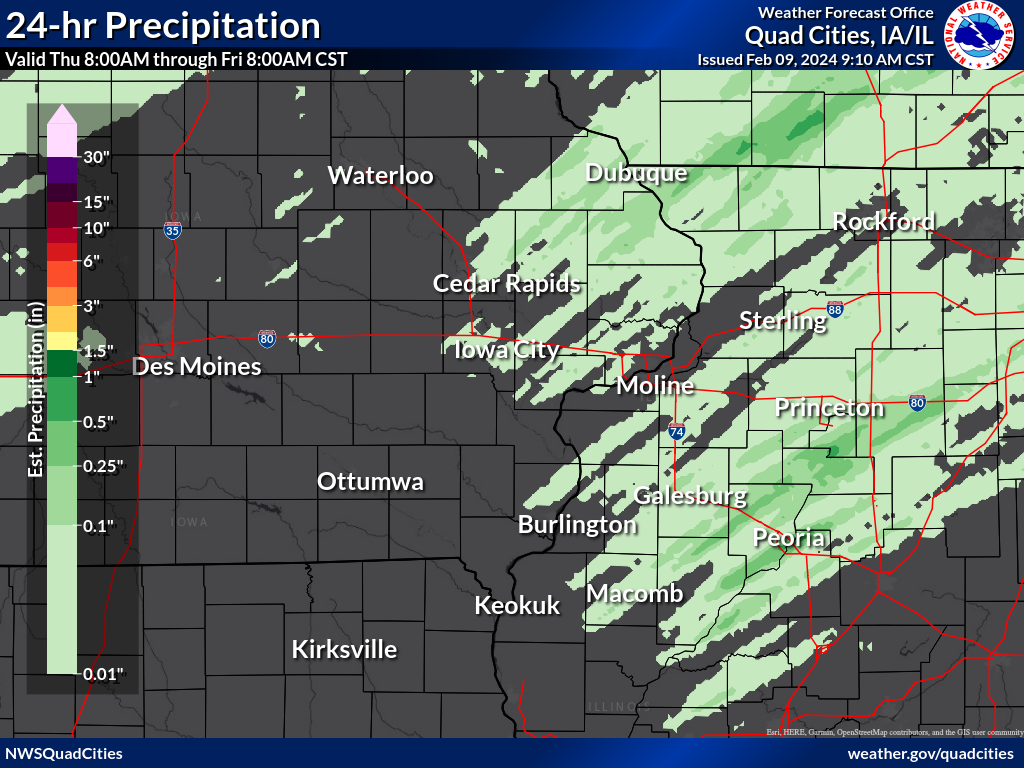
Rain Reports
| Local 24-hr Rainfall (link) |
.png) |
24 hour precipitation reports (in Inches),
for eastern Iowa, northwest and west central Illinois,
and northeast Missouri. Reported between Midnight and 9 AM,
Friday February 09, 2024.

....IOWA....
Dubuque 1.4 WNW                  0.22
Dubuque LD11                     0.10
Dubuque 1.0 SE                   0.07
Bellevue LD12                    0.05
Lowden                           0.05
Dubuque #3 7 SW                  0.03
Monticello 1 E                   0.03
Dubuque Arpt                     0.03
Independence 0.9 WNW             0.02
Mason City ASOS 6 W              0.02
Davenport Arpt                   0.01
Muscatine 3.0 NE                 0.00
Park View 0.2 WSW                0.00
Clinton 1.7 NNW                  0.00
Calamus 2.0 NE                   0.00
Charlotte 1.9 WNW                0.00
West Branch 2.3 SSW              0.00
Solon 0.4 WNW                    0.00
Iowa City 2.3 E                  0.00
North Liberty 0.7 SSW            0.00
Coralville 1.3 SE                0.00
Marengo 3.6 N                    0.00
Marion 0.9 NE                    0.00
Marion 0.4 NNW                   0.00
Robins 0.8 SE                    0.00
Cedar Rapids 2.7 NE              0.00
Marion 1.7 NNW                   0.00
Shellsburg 2.9 S                 0.00
Waukon 3N                        0.00
Oelwein 1E                       0.00
Elkader 6SSW                     0.00
Toledo 3 N                       0.00
Waterloo ASOS 5 NW               0.00
Mason City 1 NNE                 0.00
NWS Johnston* 5 NNW              0.00
Marshalltown ASOS 4 N            0.00
Cedar Rapids Arpt                0.00
Cascade                          0.00
Belle Plaine                     0.00
Iowa City Arpt                   0.00
Vinton                           0.00
Manchester                       0.00
Fort Madison 4.5 NNW             0.00
Farmington 0.4 NNW               0.00
Farmington 2.4 W                 0.00
Farmington 0.3 NW                0.00
Farmington 3.5 W                 0.00
Burlington 6.5 SSW               0.00
New London 1.5 SW                0.00
Fairfield 0.4 SE                 0.00
Wapello 5.4 SE                   0.00
Wapello 0.2 S                    0.00
Nichols 2.5 NNW                  0.00
Wellman 4.0 E                    0.00
Ainsworth 7.4 N                  0.00
Riverdale 0.5 N                  0.00
Davenport 0.9 WNW                0.00
Solon 0.3 ESE                    0.00
Marengo 2.6 SSW                  0.00
Parnell 0.1 SSW                  0.00
Cedar Rapids 2.1 NW              0.00
Central City 6.7 W               0.00
Ely 0.5 SE                       0.00
Mount Auburn 2.2 NNW             0.00
Dundee 1.4 NNE                   0.00
Oelwein AWOS                     0.00
Rathbun Reservoir 2 N            0.00
Guttenberg Dam 10                0.00
Fayette 1 NW                     0.00
Oskaloosa 1 NNW                  0.00
Perry 0 W                        0.00
Ottumwa ASOS 6 NNW               0.00
Hampton 1 N                      0.00
Marshalltown 1 NW                0.00
Centerville 0 NE                 0.00
Ames US 30 2 SSE                 0.00
Burlington Arpt                  0.00
Keosauqua                        0.00
Iowa City                        0.00
Fairfield                        0.00
Anamosa 3 SSW                    0.00
Maquoketa                        0.00
Williamsburg                     0.00
Washington                       0.00
Keokuk LD19                      0.00
Burlington 2S                    0.00
Mt Pleasant 1 SSW                0.00
Sigourney                        0.00
Grinnell 2 SW                    0.00
Boone 1 SSW                      0.00
....ILLINOIS....
McNabb 1.4 NW                    0.34
Romeoville                       0.22
Ottawa 4 SW                      0.12
Peoria Arpt                      0.06
Lena 0.3 SSE                     0.04
Freeport 2.9 WSW                 0.04
Winslow 4.3 ESE                  0.03
Stockton 3.4 NNE                 0.03
Stockton 3 NNE                   0.03
Galva 0.4 NW                     0.02
Geneseo 2.0 NW                   0.02
Lanark 4.2 NNW                   0.02
Davis 0.5 N                      0.02
Stockton 5.9 WNW                 0.02
Freeport                         0.02
Fulton LD13                      0.02
East Dubuque 1.7 SE              0.01
Mundelein                        0.01
Elizabeth                        0.01
Mount Carroll                    0.01
Colchester 3.5 NE                0.00
New Windsor 2.0 N                0.00
Rock Falls 3.1 S                 0.00
Mount Carroll 6.8 NNW            0.00
Freeport 4.3 W                   0.00
Stockton 4.6 NW                  0.00
Hanover 0.2 NW                   0.00
Rockford Arpt                    0.00
Bentley                          0.00
Aledo                            0.00
Steward                          0.00
Warsaw 5.8 SE                    0.00
Stronghurst 0.4 SSW              0.00
Viola 0.4 E                      0.00
Moline 0.7 NNE                   0.00
St Anne                          0.00
Lincoln NWS                      0.00
Macomb                           0.00
La Harpe                         0.00
Ill. City LD16 3 WNW             0.00
Gladstone LD18                   0.00
Augusta                          0.00
Quad City Arpt                   0.00
New Boston LD17                  0.00
Bloomington Airport              0.00
Decatur Airport                  0.00
Quincy Arpt                      0.00
....MISSOURI....
Columbia Arpt                    0.00
Chillicothe Arpt                 0.00
Kirksville Arpt                  0.00
Memphis                          0.00
....WISCONSIN....
Monroe 1 W                       0.20
Madison Arpt                     0.07
La Crosse WFO                    0.05
Viroqua                          0.04
Brodhead 1 SW                    0.01
Steuben 4SE 3 NE                 0.00
Beloit-College                   0.00
Whitewater                       0.00
Darlington                       0.00
Environment
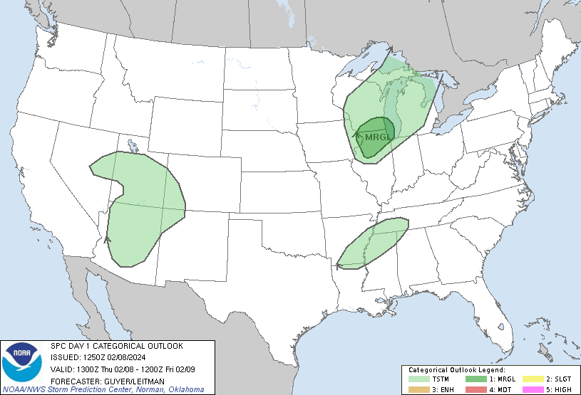
SPC Severe Weather Event Link: February 8, 2024
 |
 |
 |
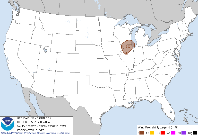 |
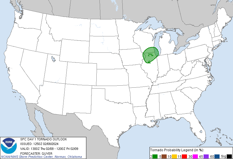
| Figure 1: 13z SPC Day 1 Outlook | Figure 2: 13z SPC Day 1 Tornado Outlook | Figure 3: 13z SPC Day 1 Hail Outlook | Figure 4: SPC Day 1 Wind Outlook |
 |
 |
||
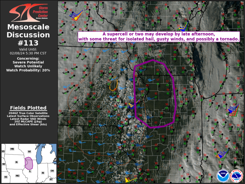
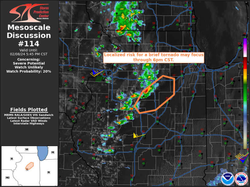
| Figure 5: SPC Mesoscale Discussion 113 | Figure 6: SPC Mesoscale Discussion 114 |
Surface / Satellite Loops
 |
 |
 |
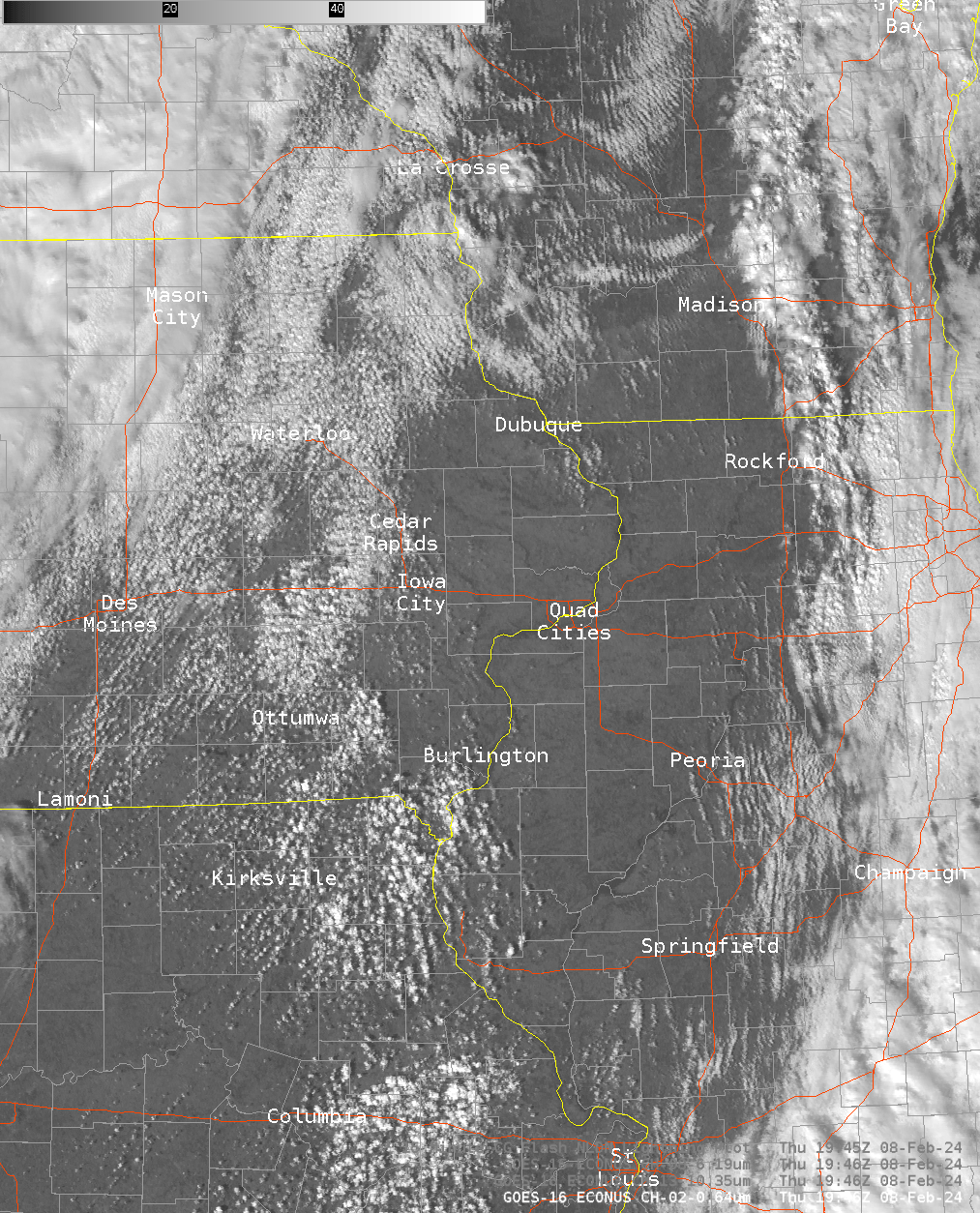 |
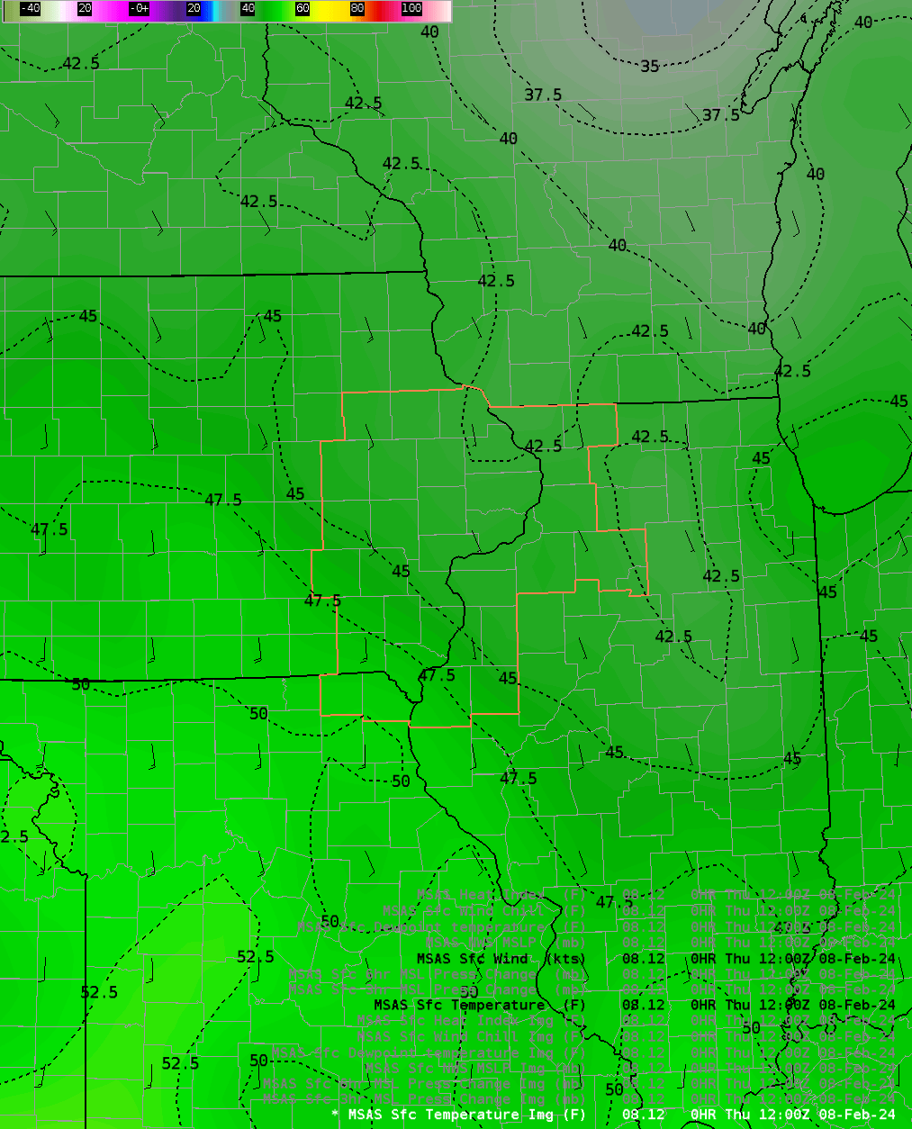
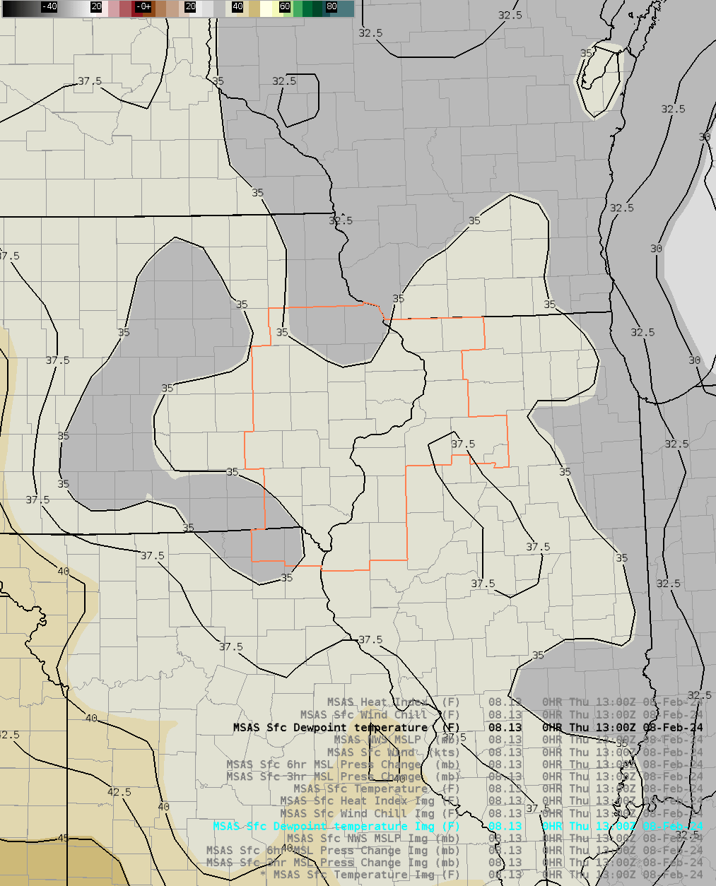
| Figure 7: MSAS Surface Temps (link) | Figure 8: MSAS Surface Dewpoints (link) | Figure 9: MSAS MSLP (link) | Figure 10: Visible Satellite (link) |
 |
 |
||
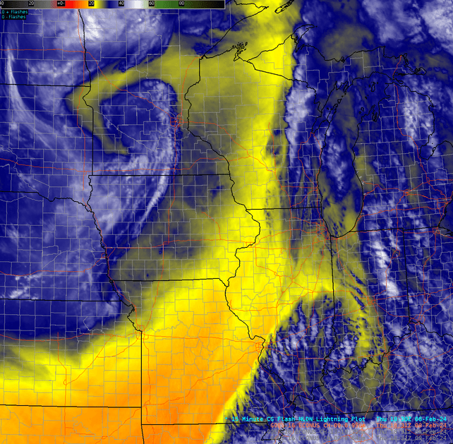
| Figure 11: Water Vapor (link) | Figure 12: IR Satellite (link) |
Near-storm environment summary
 |
 |
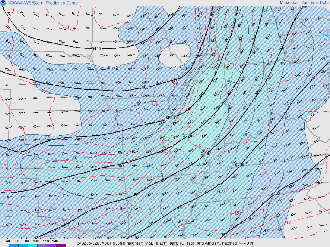 |
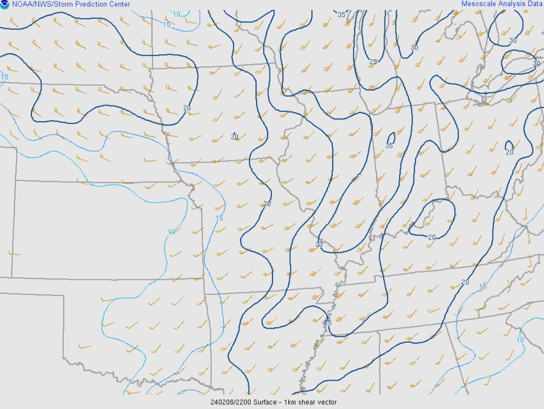
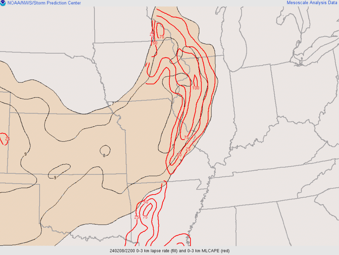
| Figure 13: 22z SPC Mesoanalysis 0-1 km shear | Figure 14: 22z SPC Mesoanalysis 0-3 km MLCAPE | Figure 15: 22z SPC Mesoanalysis 500mb winds |
 |
Media use of NWS Web News Stories is encouraged! Please acknowledge the NWS as the source of any news information accessed from this site. |
|

