Dangerous heat will expand from the Gulf Coast into the Southern Plains and Desert Southwest through week's end. Additional extreme heat impacting the Pacific Northwest will shift to the northern Plains by the weekend. Tropical Storm Bertha is expected to continue to impact portions of the northern Gulf Coast from the western Florida Panhandle to southeastern Louisiana through tonight. Read More >
Winter Storm Overview
|
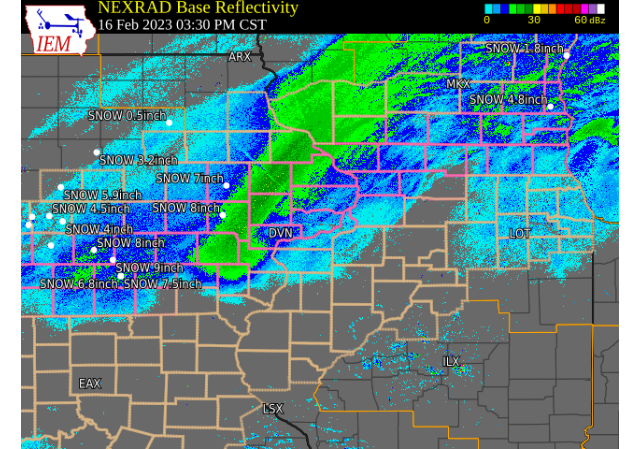
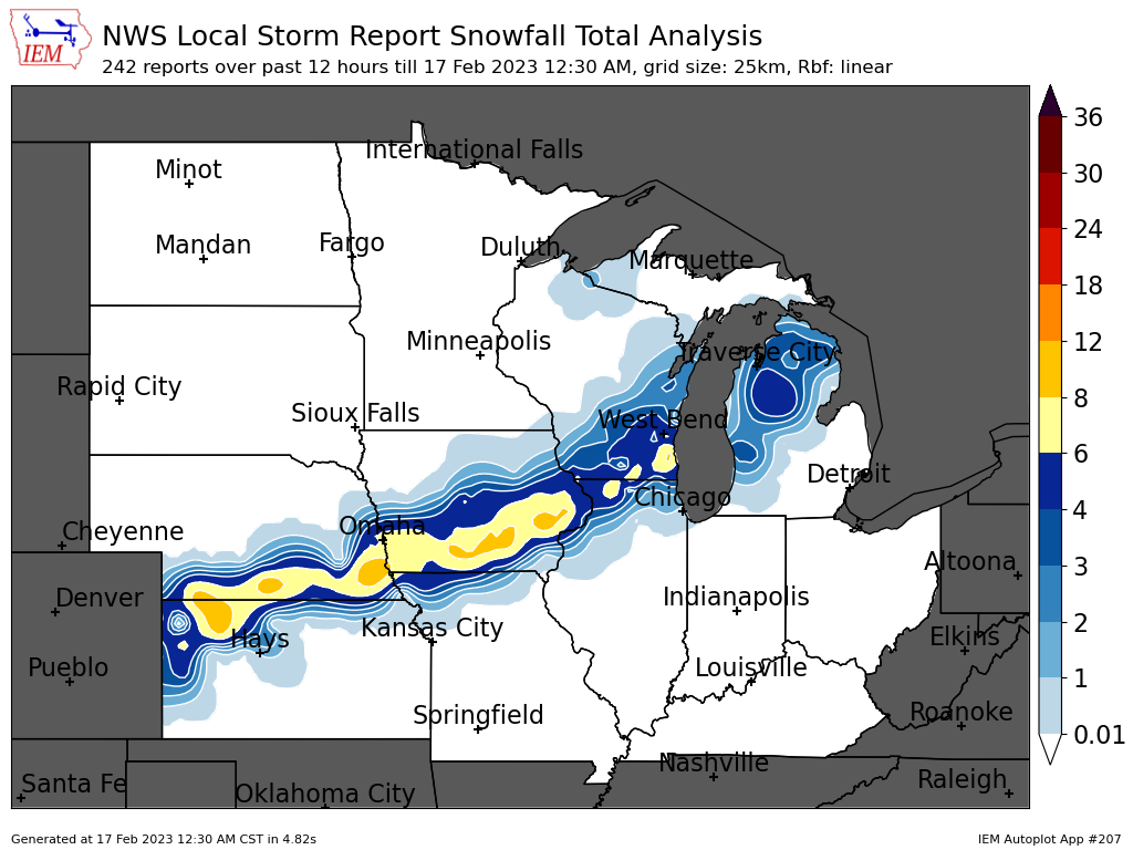
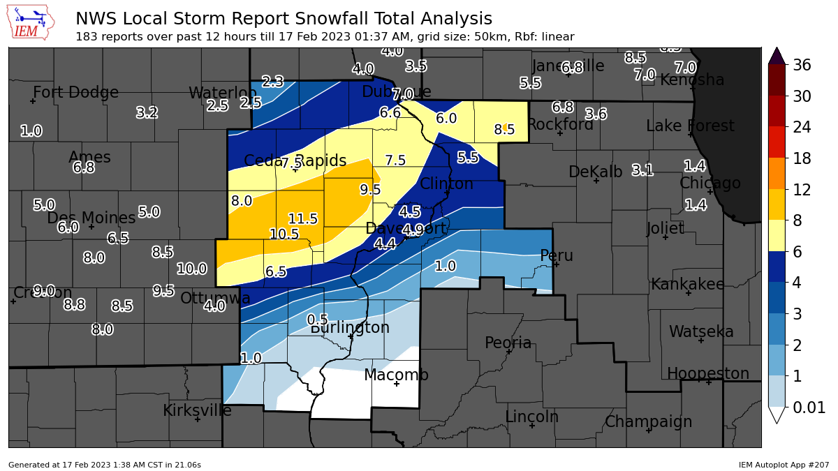
A winter storm brought moderate to heavy snow to much of eastern Iowa, northwest Illinois, and far northeast Missouri on February 16th, 2023. Snow began during the early morning across much of east central Iowa, with several locations (especially around Iowa City) seeing snow amounts around 4-6 inches around 6:00 AM. Light snow continued throughout the morning before the arrival of a stronger band of snow by early afternoon. This band impacted the Cedar Rapids / Iowa City metros during the early-mid afternoon before reaching the Mississippi River / Quad Cities metro by late afternoon and early evening, which lead to treacherous travel conditions for the evening commute. Snowfall totals ranged from around 2-6 inches in the Quad Cities / Dubuque metros, to around 7-12 inches in the Cedar Rapids / Iowa City metros. Lesser snow amounts were observed across southeast Iowa due to sleet mixing in with snow.
NWS Official Totals Moline: 2.3"
Notable (Non-NWS Official) Totals 1 SW University Heights: 11.5" (Trained Spotter) |
 Weather Prediction Center Surface Analysis/Fronts/Radar Loop |
â„ï¸ Snowfall Maps â„ï¸
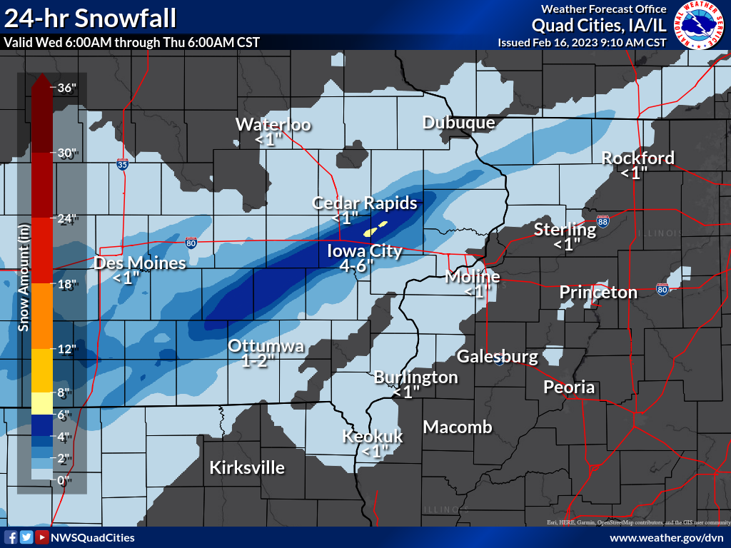
| Thursday AM (900am) Local Snowfall Map |
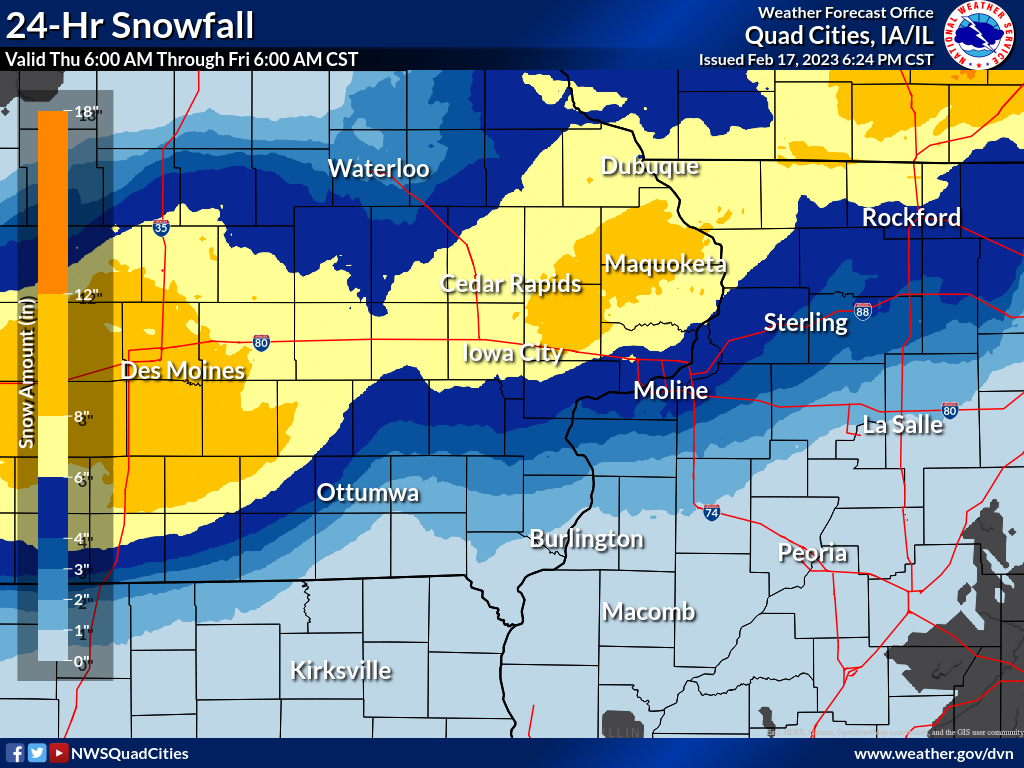
Friday AM (900am) Local Snowfall Map |
|
 |
 |
|
| Regional Snowfall Map (courtesy of IEM) | Local Snow Analysis (Courtesy IEM) | |
 |
 |
|
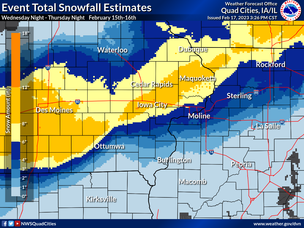
| Total Snowfall Estimate | ||
 |
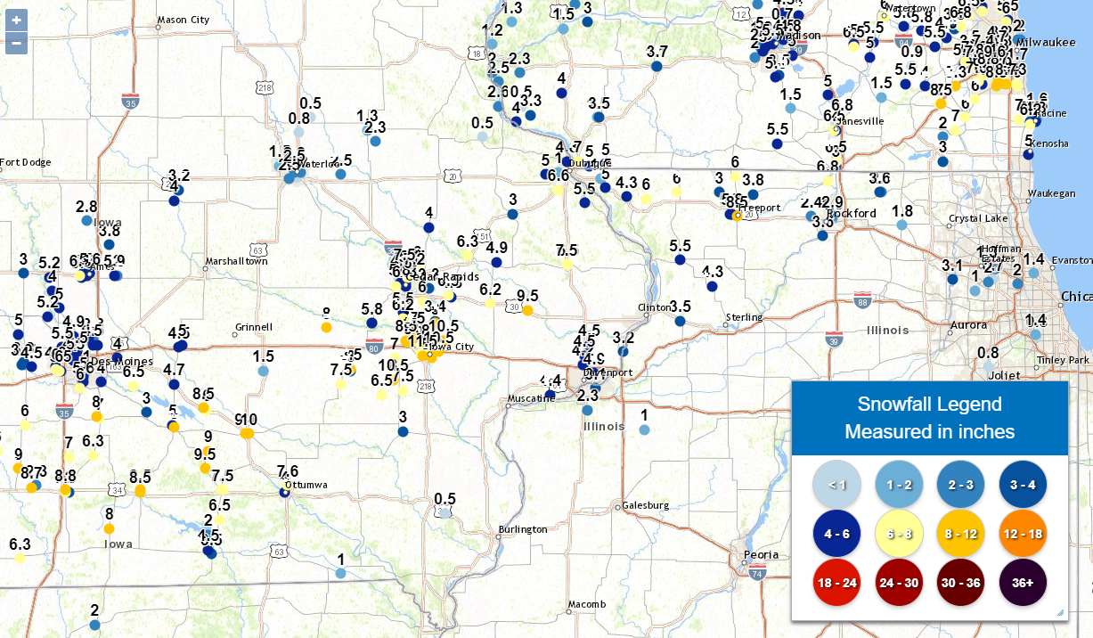
📠Storm Reports ðŸ“
Storm Reports Map - Courtesy IEM
 |
PRELIMINARY LOCAL STORM REPORT...SUMMARY
NATIONAL WEATHER SERVICE QUAD CITIES IA IL
121 AM CST FRI FEB 17 2023

..TIME...   ...EVENT...      ...CITY LOCATION...     ...LAT.LON...
..DATE...   ....MAG....      ..COUNTY LOCATION..ST.. ...SOURCE....
            ..REMARKS..

1257 AM     SNOW             1 NNW MOLINE            41.50N 90.50W
02/17/2023  M3.1 INCH        ROCK ISLAND        IL   BROADCAST MEDIA

            EVENT TOTAL.

1256 AM     SNOW             MAQUOKETA               42.07N 90.67W
02/17/2023  E6.5 INCH        JACKSON            IA   PUBLIC

            EVENT TOTAL.

1251 AM     SNOW             2 NNW NORTH LIBERTY     41.76N 91.62W
02/17/2023  M8.5 INCH        JOHNSON            IA   TRAINED SPOTTER

            EVENT TOTAL.

1250 AM     SNOW             2 W CEDAR RAPIDS        41.98N 91.71W
02/17/2023  M5.8 INCH        LINN               IA   TRAINED SPOTTER

            EVENT TOTAL.

1250 AM     SNOW             1 SSW NORTH LIBERTY     41.73N 91.62W
02/17/2023  M8.0 INCH        JOHNSON            IA   TRAINED SPOTTER

            EVENT TOTAL. LIQUID EQUIVALENT FOR THE EVENT
            WAS 0.80.

1248 AM     SNOW             KALONA                  41.49N 91.69W
02/17/2023  M7.5 INCH        WASHINGTON         IA   TRAINED SPOTTER

            EVENT TOTAL.

1247 AM     SNOW             1 NW MAQUOKETA          42.07N 90.68W
02/17/2023  M7.5 INCH        JACKSON            IA   TRAINED SPOTTER

            EVENT TOTAL.

1247 AM     SNOW             2 NNW MARION            42.06N 91.60W
02/17/2023  M6.0 INCH        LINN               IA   TRAINED SPOTTER

            EVENT TOTAL.

1246 AM     SNOW             3 N STOCKTON            42.40N 90.00W
02/17/2023  M6.0 INCH        JO DAVIESS         IL   CO-OP OBSERVER

            EVENT TOTAL.

1246 AM     SNOW             1 ENE MONTPELIER        41.47N 90.78W
02/17/2023  M4.4 INCH        SCOTT              IA   TRAINED SPOTTER

            EVENT TOTAL.

1200 AM     SNOW             3 SW QUAD CITY AIRPORT  41.40N 90.55W
02/17/2023  M2.3 INCH        ROCK ISLAND        IL   OFFICIAL NWS OBS

            EVENT TOTAL. 0.5 INCHES OF NEW SNOW SINCE
            600P.

1200 AM     SNOW             DAVENPORT AIRPORT       41.61N 90.58W
02/17/2023  M4.2 INCH        SCOTT              IA   OFFICIAL NWS OBS

            EVENT TOTAL. 0.3 INCHES OF NEW SNOW SINCE
            600P.

1200 AM     SNOW             1 NW DUBUQUE REGIONAL A 42.41N 90.73W
02/17/2023  M6.6 INCH        DUBUQUE            IA   OFFICIAL NWS OBS

            EVENT TOTAL. 0.4 INCHES OF NEW SNOW SINCE
            600P.

1024 PM     SNOW             MOUNT CARROLL           42.09N 89.98W
02/16/2023  M5.5 INCH        CARROLL            IL   TRAINED SPOTTER


1010 PM     HEAVY SNOW       FREEPORT                42.29N 89.63W
02/16/2023  M8.5 INCH        STEPHENSON         IL   TRAINED SPOTTER

            UPDATED AND STORM TOTAL.

1009 PM     HEAVY SNOW       FREEPORT                42.29N 89.63W
02/16/2023  M7.6 INCH        STEPHENSON         IL   PUBLIC

            PUBLIC REPORT RELAYED BY MEDIA.

1000 PM     HEAVY SNOW       2 SE IOWA CITY          41.64N 91.51W
02/16/2023  M8.8 INCH        JOHNSON            IA   TRAINED SPOTTER

            STORM TOTAL.

0959 PM     SNOW             2 SSE SCHAPVILLE        42.37N 90.19W
02/16/2023  M6.0 INCH        JO DAVIESS         IL   TRAINED SPOTTER


0956 PM     SNOW             2 WNW FREEPORT          42.30N 89.66W
02/16/2023  M5.8 INCH        STEPHENSON         IL   TRAINED SPOTTER


0950 PM     SNOW             1 ENE WASHINGTON        41.30N 91.68W
02/16/2023  M5.8 INCH        WASHINGTON         IA   PUBLIC


0938 PM     SNOW             PARK VIEW               41.70N 90.54W
02/16/2023  M4.5 INCH        SCOTT              IA   NWS EMPLOYEE

            SNOW AND SLEET TOTAL.

0931 PM     SNOW             1 N ELDRIDGE            41.66N 90.57W
02/16/2023  E4.5 INCH        SCOTT              IA   NWS EMPLOYEE

            EVENT TOTAL.

0930 PM     SNOW             1 N ELDRIDGE            41.65N 90.57W
02/16/2023  M4.5 INCH        SCOTT              IA   NWS EMPLOYEE

            EVENT TOTAL.

0930 PM     SNOW             CANTRIL                 40.64N 92.07W
02/16/2023  E1.0 INCH        VAN BUREN          IA   TRAINED SPOTTER

            SNOW TOTAL AROUND AN INCH. SOME FREEZING
            RAIN PRIOR TO THE SNOW ACCUMULATION.

0925 PM     SNOW             ANAMOSA                 42.11N 91.29W
02/16/2023  M6.3 INCH        JONES              IA   TRAINED SPOTTER


0915 PM     SNOW             1 SSW CORDOVA           41.67N 90.33W
02/16/2023  M3.2 INCH        ROCK ISLAND        IL   TRAINED SPOTTER

            STORM TOTAL.

0905 PM     SNOW             1 WNW CAMBRIDGE         41.31N 90.20W
02/16/2023  M1.0 INCH        HENRY              IL   PUBLIC

            LIGHT FREEZING RAIN GLAZE ON ELEVATED
            SURFACES FROM EARLIER IN THE DAY.

0815 PM     HEAVY SNOW       1 NE HIAWATHA           42.05N 91.68W
02/16/2023  M7.5 INCH        LINN               IA   TRAINED SPOTTER

            STORM TOTAL.

0802 PM     HEAVY SNOW       STANWOOD                41.89N 91.15W
02/16/2023  M6.2 INCH        CEDAR              IA   TRAINED SPOTTER

            UPDATED TOTAL. STORM TOTAL.

0800 PM     SNOW             1 W MORRISON            41.81N 89.98W
02/16/2023  M3.5 INCH        WHITESIDE          IL   TRAINED SPOTTER

            STORM TOTAL. JUST LIGHT SNOW FALLING AT TIME
            OF REPORT.

0758 PM     SNOW             MILLEDGEVILLE           41.97N 89.78W
02/16/2023  M4.3 INCH        CARROLL            IL   TRAINED SPOTTER

            STORM TOTAL.

0737 PM     SNOW             2 SSW WILLIAMSTOWN      41.54N 91.75W
02/16/2023  M10.5 INCH       JOHNSON            IA   TRAINED SPOTTER

            TOTAL LIQUID EQUIVALENT FROM THIS SNOW
            EQUALS 1.18.

0735 PM     SNOW             2 W BETTENDORF          41.57N 90.51W
02/16/2023  M4.9 INCH        SCOTT              IA   NWS EMPLOYEE

            STORM TOTAL.

0731 PM     SNOW             PARNELL                 41.59N 92.01W
02/16/2023  M8.5 INCH        IOWA               IA   TRAINED SPOTTER


0725 PM     HEAVY SNOW       LOWDEN                  41.86N 90.92W
02/16/2023  M9.5 INCH        CEDAR              IA   CO-OP OBSERVER

            UPDATED AMOUNT AND STORM TOTAL. SNOW HAS
            ENDED.

0711 PM     SNOW             1 WSW JULIEN            42.48N 90.81W
02/16/2023  M5.0 INCH        DUBUQUE            IA   TRAINED SPOTTER


0708 PM     SNOW             1 SSE EDMORE            42.54N 90.68W
02/16/2023  M4.8 INCH        DUBUQUE            IA   TRAINED SPOTTER

            STORM TOTAL.

0653 PM     SNOW             3 NNE CEDAR RAPIDS      42.01N 91.66W
02/16/2023  M6.0 INCH        LINN               IA   PUBLIC

            EVENT TOTAL.

0640 PM     HEAVY SNOW       1 ENE MOUNT VERNON      41.93N 91.41W
02/16/2023  M6.5 INCH        LINN               IA   TRAINED SPOTTER

            UPDATED TOTAL. STORM TOTAL.

0637 PM     SNOW             MILLEDGEVILLE           41.97N 89.78W
02/16/2023  M4.1 INCH        CARROLL            IL   TRAINED SPOTTER


0630 PM     HEAVY SNOW       1 WSW SAINT DONATUS     42.35N 90.57W
02/16/2023  M5.5 INCH        JACKSON            IA   TRAINED SPOTTER

            STORM TOTAL.

0625 PM     HEAVY SNOW       3 W CEDAR RAPIDS        41.97N 91.73W
02/16/2023  M6.0 INCH        LINN               IA   TRAINED SPOTTER

            STORM TOTAL.

0622 PM     HEAVY SNOW       ORANGEVILLE             42.47N 89.64W
02/16/2023  M6.0 INCH        STEPHENSON         IL   TRAINED SPOTTER

            STILL SNOWING.

0620 PM     SNOW             1 ENE ANAMOSA           42.12N 91.27W
02/16/2023  M5.1 INCH        JONES              IA   TRAINED SPOTTER


0620 PM     HEAVY SNOW       SOLON                   41.80N 91.49W
02/16/2023  M8.0 INCH        JOHNSON            IA   TRAINED SPOTTER

            STORM TOTAL.

0615 PM     HEAVY SNOW       1 SW UNIVERSITY HEIGHTS 41.65N 91.57W
02/16/2023  M11.5 INCH       JOHNSON            IA   TRAINED SPOTTER

            STORM TOTAL.

0614 PM     HEAVY SNOW       NORTH ENGLISH           41.52N 92.07W
02/16/2023  M7.5 INCH        IOWA               IA   PUBLIC

            STORM TOTAL.

0608 PM     SNOW             2 N CENTRAL CITY        42.24N 91.53W
02/16/2023  M4.0 INCH        LINN               IA   TRAINED SPOTTER


0608 PM     SNOW             1 WNW GALENA            42.42N 90.44W
02/16/2023  M5.0 INCH        JO DAVIESS         IL   TRAINED SPOTTER


0521 PM     SNOW             4 ENE IOWA CITY         41.67N 91.47W
02/16/2023  M10.5 INCH       JOHNSON            IA   TRAINED SPOTTER

            STORM TOTAL, SNOW IS VERY VERY LIGHT NOW.

0515 PM     SNOW             5 S WEST CHESTER        41.27N 91.83W
02/16/2023  M6.5 INCH        WASHINGTON         IA   PUBLIC


0515 PM     HEAVY SNOW       1 W ELMIRA              41.72N 91.44W
02/16/2023  M10.5 INCH       JOHNSON            IA   TRAINED SPOTTER

            UPDATES PREVIOUS HEAVY SNOW REPORT. STILL
            SNOWING LIGHTLY.

0501 PM     FREEZING RAIN    3 NNW OAKLAND MILLS     40.97N 91.63W
02/16/2023  M1.80 INCH       HENRY              IA   TRAINED SPOTTER

            STILL SNOWING.

0459 PM     SNOW             2 SE GALENA TERRITORY   42.38N 90.31W
02/16/2023  M4.3 INCH        JO DAVIESS         IL   TRAINED SPOTTER

            STILL SNOWING.

0457 PM     SNOW             1 WSW AMANA             41.80N 91.88W
02/16/2023  M5.8 INCH        IOWA               IA   TRAINED SPOTTER


0430 PM     SNOW             JESUP                   42.48N 92.07W
02/16/2023  M2.5 INCH        BUCHANAN           IA   PUBLIC


0428 PM     SNOW             SWISHER                 41.85N 91.69W
02/16/2023  M5.5 INCH        JOHNSON            IA   PUBLIC


0428 PM     SNOW             2 W MARION              42.03N 91.62W
02/16/2023  M7.2 INCH        LINN               IA   PUBLIC


0413 PM     SNOW             3 SW CENTER JUNCTION    42.08N 91.11W
02/16/2023  M4.9 INCH        JONES              IA   PUBLIC
 |
Media use of NWS Web News Stories is encouraged! Please acknowledge the NWS as the source of any news information accessed from this site. |
|