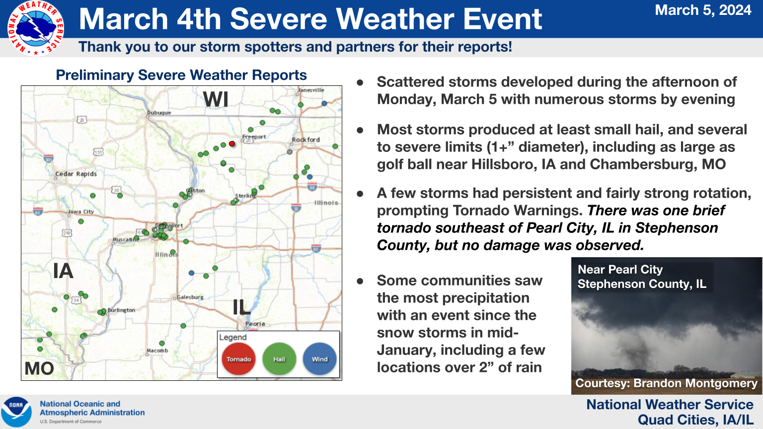
Storm Reports...Summary

..TIME...   ...EVENT...      ...CITY LOCATION...     ...LAT.LON...
..DATE...   ....MAG....      ..COUNTY LOCATION..ST.. ...SOURCE....
            ..REMARKS..

1243 PM     Hail             Charlotte               41.96N 90.47W
03/04/2024  E0.50 inch       Clinton            IA   Public

            Report from mPING: Half-inch (0.50 in.).

0129 PM     Hail             5 SSE Massbach          42.18N 90.08W
03/04/2024  M1.00 inch       Carroll            IL   Trained Spotter

            Delayed Report, Near intersection of Zion Rd
            and Elizabeth Rd, time estimated from radar.

0155 PM     Hail             Folletts                41.75N 90.35W
03/04/2024  E0.75 inch       Clinton            IA   Public

            Delayed report via social media. Lasted 10
            minutes.

0159 PM     Hail             2 SSW Clinton           41.82N 90.25W
03/04/2024  M0.25 inch       Clinton            IA   Trained Spotter

            Occurring right now and covering the ground.

0159 PM     Tornado          3 W Bolton              42.24N 89.78W
03/04/2024                   Stephenson         IL   Storm Chaser

            Pictures and video from a storm chaser
            confirm a brief tornado southeast of Pearl
            City Monday afternoon. The Stephenson County
            Emergency Manager surveyed the area and did
            not see any damage. Therefore, the tornado
            is rated EF-Unknown.

0205 PM     Hail             3 W Clinton             41.84N 90.28W
03/04/2024  E0.25 inch       Clinton            IA   Trained Spotter

            pea hail for about 5 minutes starting around
            205 PM.

0205 PM     Hail             4 NE Clinton            41.88N 90.18W
03/04/2024  E0.25 inch       Clinton            IA   Trained Spotter

            Pea size hail with heavy rain, no
            accumulation of hail.

0212 PM     Hail             2 ENE Clinton           41.85N 90.20W
03/04/2024  M0.25 inch       Clinton            IA   Trained Spotter

            pea hail.

0213 PM     Hail             Clinton                 41.84N 90.20W
03/04/2024  E0.88 inch       Clinton            IA   911 Call Center

            Dime to nickel size hail in Clinton.

0232 PM     Hail             1 N Dakota              42.39N 89.53W
03/04/2024  M0.70 inch       Stephenson         IL   Trained Spotter

            pea to dime size hail began about 232 pm.

0242 PM     Hail             2 NNW Fruitland         41.49N 90.53W
03/04/2024  E0.25 inch       Rock Island        IL   Trained Spotter

            Most hail pea size, with some globs of
            half-inch.

0243 PM     Hail             1 NNE Fruitland         41.48N 90.51W
03/04/2024  M0.25 inch       Rock Island        IL   Broadcast Media

            At WQAD.

0243 PM     Hail             Orion                   41.35N 90.38W
03/04/2024  E0.50 inch       Henry              IL   Public

            Report from mPING: Half-inch (0.50 in.).

0243 PM     Hail             Moline                  41.49N 90.48W
03/04/2024  E0.70 inch       Rock Island        IL   Public

            Delayed report via social media.

0244 PM     Hail             1 ENE Montpelier        41.47N 90.78W
03/04/2024  M0.25 inch       Scott              IA   Trained Spotter

            Via social media. Lasted 10 minutes.

0245 PM     Hail             2 ESE Moline            41.48N 90.46W
03/04/2024  E0.25 inch       Rock Island        IL   Trained Spotter

            near 60th and 34th.

0245 PM     Hail             1 WNW Bettendorf        41.57N 90.50W
03/04/2024  M0.88 inch       Scott              IA   Trained Spotter

            Hail started at approximately 2:45 and
            lasted until 2:57. Hail covered ground.

0247 PM     Hail             4 NE Clinton            41.88N 90.18W
03/04/2024  E0.75 inch       Clinton            IA   Public

            Report from mPING: Dime (0.75 in.).

0247 PM     Hail             1 NNE Moline            41.49N 90.48W
03/04/2024  E0.75 inch       Rock Island        IL   Public

            Report from mPING: Dime (0.75 in.).

0248 PM     Hail             4 NE Clinton            41.88N 90.18W
03/04/2024  E0.75 inch       Clinton            IA   Public

            Report from mPING: Dime (0.75 in.).

0248 PM     Hail             1 NNE Bettendorf        41.58N 90.47W
03/04/2024  M0.88 inch       Scott              IA   Trained Spotter

            Occurring right now.

0249 PM     Hail             2 NW Moline             41.50N 90.51W
03/04/2024  M0.70 inch       Rock Island        IL   Broadcast Media

            WQAD TV Met.

0249 PM     Hail             2 WSW Riverdale         41.53N 90.51W
03/04/2024  M1.00 inch       Scott              IA   Public

            Dime to quarter size hail.

0250 PM     Hail             2 W Bettendorf          41.56N 90.51W
03/04/2024  M1.00 inch       Scott              IA   Trained Spotter

            Via social media picture.

0250 PM     Hail             1 NNE Bettendorf        41.58N 90.47W
03/04/2024  E1.00 inch       Scott              IA   Trained Spotter

            Dime to quarter size hail.

0250 PM     Hail             1 W Bettendorf          41.57N 90.49W
03/04/2024  E1.50 inch       Scott              IA   NWS Employee

            Numerous small stones but a few stones to
            ping pong ball size. Time estimated using
            radar.

0250 PM     Hail             1 SE Moline             41.47N 90.48W
03/04/2024  E0.70 inch       Rock Island        IL   Trained Spotter

            Via social media.

0251 PM     Hail             1 NE Bettendorf         41.57N 90.47W
03/04/2024  M1.00 inch       Scott              IA   Trained Spotter


0251 PM     Hail             2 WSW Bettendorf        41.56N 90.51W
03/04/2024  E1.00 inch       Scott              IA   Public


0252 PM     Hail             2 WNW Bettendorf        41.57N 90.51W
03/04/2024  E0.50 inch       Scott              IA   Public

            Report from mPING: Half-inch (0.50 in.).

0253 PM     Hail             2 WSW Riverdale         41.53N 90.51W
03/04/2024  E1.00 inch       Scott              IA   Public

            Nickel to quarter sized hail.

0253 PM     Hail             2 WNW Bettendorf        41.57N 90.51W
03/04/2024  M0.75 inch       Scott              IA   Public


0256 PM     Hail             1 WNW Bettendorf        41.57N 90.50W
03/04/2024  M0.70 inch       Scott              IA   Public


0300 PM     Hail             4 NE Morristown         41.44N 90.24W
03/04/2024  M1.00 inch       Henry              IL   Storm Chaser

            Extensive quarter sized hail had virtually
            stopped traffic along I-80 west of Geneseo.
            estimated around MM15 around 3 pm. Time
            based on radar.

0301 PM     Hail             1 WNW Bettendorf        41.57N 90.50W
03/04/2024  M0.88 inch       Scott              IA   Trained Spotter

            Dime to Nickel size hail.

0305 PM     Hail             4 N Hitt                42.05N 89.74W
03/04/2024  E0.50 inch       Carroll            IL   Public

            Report from mPING: Half-inch (0.50 in.).

0305 PM     Hail             Lanark                  42.11N 89.83W
03/04/2024  E1.00 inch       Carroll            IL   Public


0335 PM     Hail             2 ENE Hillsboro         40.85N 91.68W
03/04/2024  M1.75 inch       Henry              IA   Public

            Delayed report via social media picture.

0336 PM     Hail             3 ENE Charlie Heath Mem 40.59N 91.84W
03/04/2024  M0.88 inch       Clark              MO   Trained Spotter

            Occurring right now.

0339 PM     Hail             3 ENE Charlie Heath Mem 40.59N 91.84W
03/04/2024  M1.00 inch       Clark              MO   Trained Spotter

            Occurring right now; intermixed with peas
            and dimes.

0349 PM     Hail             Mount Pleasant          40.96N 91.55W
03/04/2024  E0.88 inch       Henry              IA   Amateur Radio

            Occurring right now.

0358 PM     Hail             2 ENE Spring Lake       41.52N 90.69W
03/04/2024  E0.75 inch       Scott              IA   Public

            Report from mPING: Dime (0.75 in.).

0400 PM     Hail             2 E Spring Lake         41.51N 90.67W
03/04/2024  M1.00 inch       Scott              IA   Public

            quarter hail at I-280 and Highway 61.

0406 PM     Hail             2 WSW Chambersburg      40.51N 91.84W
03/04/2024  E1.50 inch       Clark              MO   Public

            Report from mPING: Ping Pong Ball (1.50
            in.).

0407 PM     Hail             2 WSW Chambersburg      40.51N 91.84W
03/04/2024  E1.75 inch       Clark              MO   Public

            Report from mPING: Golf Ball (1.75 in.).

0412 PM     Hail             1 N Rock Island         41.49N 90.58W
03/04/2024  M1.00 inch       Rock Island        IL   Public

            Delayed report via social media picture.

0415 PM     Hail             1 S Sterling            41.79N 89.69W
03/04/2024  E0.50 inch       Whiteside          IL   Public

            Report from mPING: Half-inch (0.50 in.).

0415 PM     Hail             1 W Rock Falls          41.77N 89.72W
03/04/2024  E1.00 inch       Whiteside          IL   Public

            Report from mPING: Quarter (1.00 in.).

0416 PM     Hail             4 NNE New London        40.99N 91.39W
03/04/2024  E0.75 inch       Henry              IA   Public

            Report from mPING: Dime (0.75 in.).

0427 PM     Hail             Hampton                 41.55N 90.41W
03/04/2024  E0.50 inch       Rock Island        IL   Public

            Report from mPING: Half-inch (0.50 in.).

0518 PM     Rain             1 NNE Bettendorf        41.58N 90.47W
03/04/2024  M1.35 inch       Scott              IA   Trained Spotter

            Over the past 2.5 hours.

0530 PM     Hail             West Burlington         40.83N 91.18W
03/04/2024  E0.88 inch       Des Moines         IA   Public


0537 PM     Hail             1 E West Burlington     40.82N 91.15W
03/04/2024  M1.00 inch       Des Moines         IA   Trained Spotter


0543 PM     Hail             Farmington              40.64N 91.74W
03/04/2024  M1.00 inch       Van Buren          IA   Public

            Reported at Caseys.

0546 PM     Hail             2 NNW Burlington        40.84N 91.14W
03/04/2024  E0.75 inch       Des Moines         IA   Public

            Report from mPING: Dime (0.75 in.).

0700 PM     Hail             2 WSW Downey            41.61N 91.39W
03/04/2024  E0.25 inch       Johnson            IA   Trained Spotter


0702 PM     Hail             3 SW Lowden             41.83N 90.96W
03/04/2024  M0.25 inch       Cedar              IA   Trained Spotter


0715 PM     Hail             1 W Fort Madison        40.62N 91.37W
03/04/2024  E0.50 inch       Lee                IA   Public

            Report from mPING: Half-inch (0.50 in.).

0718 PM     Hail             1 N Fort Madison        40.63N 91.35W
03/04/2024  M1.00 inch       Lee                IA   Public

            Largest stones were quarter size. Picture
            from social media.

0804 PM     Tstm Wnd Dmg     Nekoma                  41.17N 90.18W
03/04/2024                   Henry              IL   Emergency Mngr

            4 to 5 inch tree limbs down. Also, dime size
            hail.

0807 PM     Rain             5 SSE Sperry            40.89N 91.10W
03/04/2024  M1.96 inch       Des Moines         IA   Trained Spotter

            Rainfall total from 5:30 to 7:45 pm.

0832 PM     Hail             Bushnell                40.56N 90.50W
03/04/2024  M1.00 inch       McDonough          IL   Trained Spotter

            Relayed by NWS Lincoln.

0834 PM     Hail             4 NE Cedar Bluff        41.83N 91.26W
03/04/2024  M1.00 inch       Cedar              IA   Trained Spotter


0839 PM     Hail             2 SSE Kewanee           41.21N 89.92W
03/04/2024  M0.70 inch       Henry              IL   Emergency Mngr

            Large amounts of dime size hail.

0933 PM     Hail             Loran                   42.23N 89.91W
03/04/2024  M0.88 inch       Stephenson         IL   Public


0934 PM     Hail             6 SSE Elmoville         42.19N 90.02W
03/04/2024  E0.70 inch       Carroll            IL   Trained Spotter


0943 PM     Hail             Pearl City              42.26N 89.83W
03/04/2024  E0.75 inch       Stephenson         IL   Public

            Report from mPING: Dime (0.75 in.).

0741 AM     Rain             1 W Bettendorf          41.56N 90.49W
03/05/2024  M1.31 inch       Scott              IA   Trained Spotter

            24 hour total.

1002 AM     Rain             3 ENE Charlie Heath Mem 40.59N 91.84W
03/05/2024  M1.80 inch       Clark              MO   Trained Spotter

            Updated rainfall total from the last 24
            hours.

