
Widespread life-threatening flash and urban flooding continues in south-central Texas, with considerable flooding impacts possible across central Texas. Wildfire smoke is impacting air quality across much of the Great Lakes region into southern New England and the Mid-Atlantic. Monsoonal thunderstorms may produce isolated to scattered flash flooding across the Southwest into the Great Basin. Read More >
Overview
|
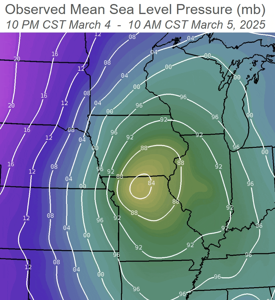
A strong area of low pressure moved across the Midwest on March 4th and 5th, producing a plethora of hazardous weather to the region. This low first brought soaking rainfall on March 4th, with numerous locations reporting between one to two inches of total rainfall. Frost depths by this time were down to zero inches, which helped the rain to soak into the ground. March 5th saw a transition from the rain to more of a rain/snow mix or all snow, especially for areas west of the Mississippi River. We also saw very strong northwest winds across the area, with numerous locations reporting max wind gusts between 40 to 50+ mph. Although the snow was relatively light (less than 2 inches), the strong winds helped lead to blowing snow and reduced visibilities down to a quarter of a mile in Dubuque and Cedar Rapids. Additionally, the winds resulted in sporadic power outages over the area. Highest Gusts |
Central Iowa Event Summary (NWS Des Moines) |
Rainfall Reports
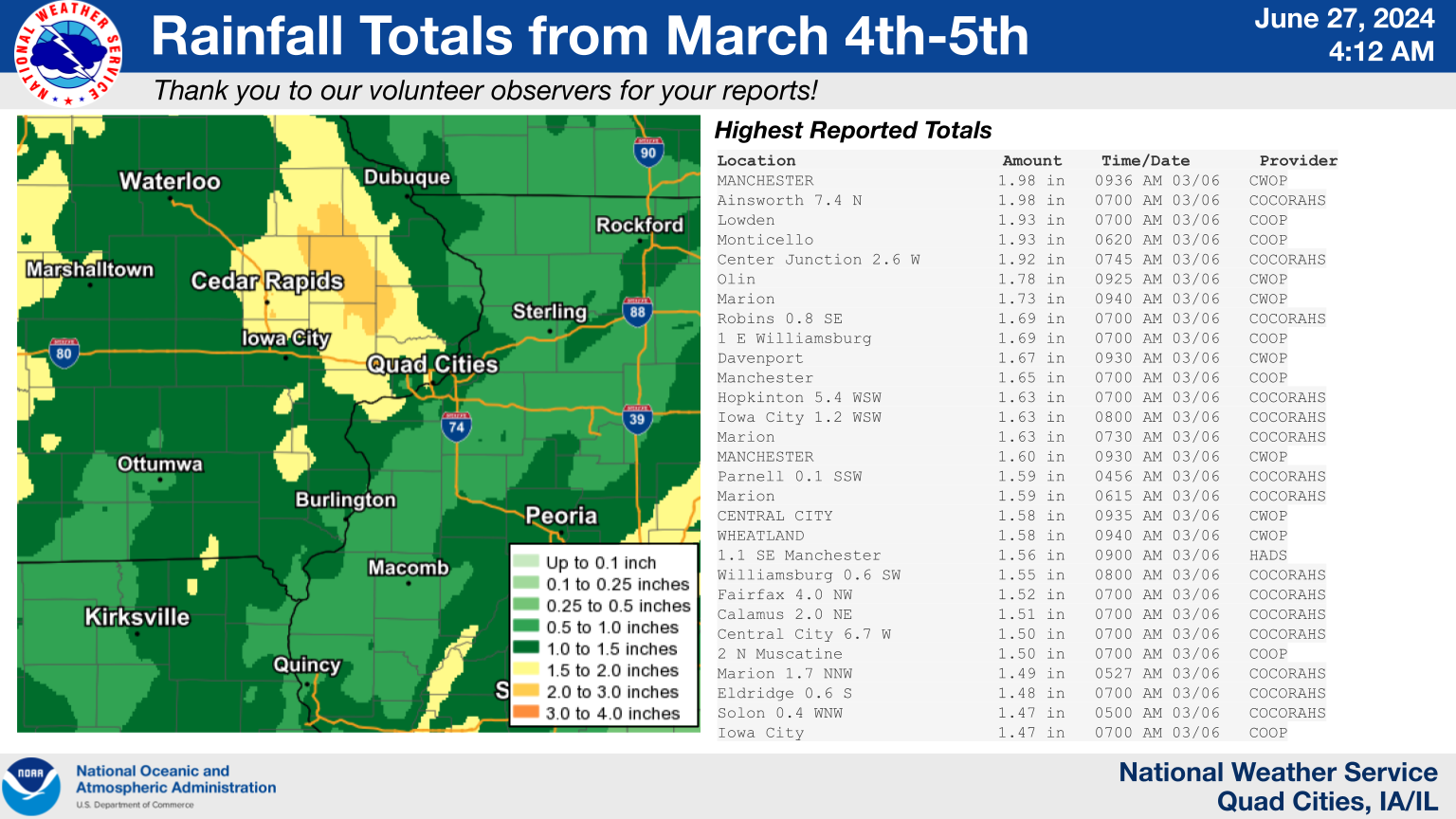
Public Information Statement
National Weather Service Quad Cities IA IL
955 AM CST Thu Mar 6 2025

...Highest Rainfall Reports Past 48 Hours...

Observations are collected from a variety of sources with varying
equipment and exposures. We thank all volunteer weather observers
for their dedication. Not all data listed are considered official.

Location                     Amount    Time/Date       Provider
MANCHESTER                   1.98 in   0936 AM 03/06   CWOP
Ainsworth 7.4 N              1.98 in   0700 AM 03/06   COCORAHS
Lowden                       1.93 in   0700 AM 03/06   COOP
Monticello                   1.93 in   0620 AM 03/06   COOP
Center Junction 2.6 W        1.92 in   0745 AM 03/06   COCORAHS
Olin                         1.78 in   0925 AM 03/06   CWOP
Marion                       1.73 in   0940 AM 03/06   CWOP
Robins 0.8 SE                1.69 in   0700 AM 03/06   COCORAHS
1 E Williamsburg             1.69 in   0700 AM 03/06   COOP
Davenport                    1.67 in   0930 AM 03/06   CWOP
Manchester                   1.65 in   0700 AM 03/06   COOP
Hopkinton 5.4 WSW            1.63 in   0700 AM 03/06   COCORAHS
Iowa City 1.2 WSW            1.63 in   0800 AM 03/06   COCORAHS
Marion                       1.63 in   0730 AM 03/06   COCORAHS
MANCHESTER                   1.60 in   0930 AM 03/06   CWOP
Parnell 0.1 SSW              1.59 in   0456 AM 03/06   COCORAHS
Marion                       1.59 in   0615 AM 03/06   COCORAHS
CENTRAL CITY                 1.58 in   0935 AM 03/06   CWOP
WHEATLAND                    1.58 in   0940 AM 03/06   CWOP
1.1 SE Manchester            1.56 in   0900 AM 03/06   HADS
Williamsburg 0.6 SW          1.55 in   0800 AM 03/06   COCORAHS
Fairfax 4.0 NW               1.52 in   0700 AM 03/06   COCORAHS
Calamus 2.0 NE               1.51 in   0700 AM 03/06   COCORAHS
Central City 6.7 W           1.50 in   0700 AM 03/06   COCORAHS
2 N Muscatine                1.50 in   0700 AM 03/06   COOP
Marion 1.7 NNW               1.49 in   0527 AM 03/06   COCORAHS
Eldridge 0.6 S               1.48 in   0700 AM 03/06   COCORAHS
Solon 0.4 WNW                1.47 in   0500 AM 03/06   COCORAHS
Iowa City                    1.47 in   0700 AM 03/06   COOP
SHELLSBURG                   1.46 in   0936 AM 03/06   CWOP
Eldridge 0.7 SSW             1.46 in   0800 AM 03/06   COCORAHS
Independence                 1.45 in   0930 AM 03/06   CWOP
Illinois City 6.7 SW         1.45 in   0800 AM 03/06   COCORAHS
Mount Pleasant 3.1 WNW       1.44 in   0800 AM 03/06   COCORAHS
Iowa City 2.3 E              1.44 in   0700 AM 03/06   COCORAHS
Iowa City 1.4 NNE            1.44 in   0700 AM 03/06   COCORAHS
Marengo 2.6 SSW              1.43 in   0600 AM 03/06   COCORAHS
North Liberty 0.7 SSW        1.42 in   0730 AM 03/06   COCORAHS
1 NE Watkins                 1.41 in   0935 AM 03/06   AWS
Memphis                      1.41 in   0700 AM 03/06   COOP
Davenport 6 N                1.40 in   0600 AM 03/06   COOP
University Heights           1.39 in   0700 AM 03/06   COCORAHS
Cedar River Tnc Swamp        1.36 in   0846 AM 03/06   RAWS
IOWA CITY                    1.35 in   0938 AM 03/06   CWOP
Davenport 4.3 NE             1.34 in   0700 AM 03/06   COCORAHS
Solon 0.3 ESE                1.33 in   0700 AM 03/06   COCORAHS
Shimek State Forest          1.32 in   0907 AM 03/06   RAWS
Eldridge                     1.32 in   0939 AM 03/06   CWOP
Park View 0.2 WSW            1.32 in   0700 AM 03/06   COCORAHS
Iowa City Arpt               1.30 in   0852 AM 03/06   ASOS
Salem 1 S                    1.30 in   0700 AM 03/06   COOP
Fairfield                    1.30 in   0800 AM 03/06   COOP
3 S Mount Joy                1.29 in   0935 AM 03/06   AWS
Marion                       1.29 in   0930 AM 03/06   CWOP
2 NNW Manchester Airport     1.28 in   0935 AM 03/06   AWS
Donnellson                   1.28 in   0700 AM 03/06   COOP
Riverside                    1.28 in   0931 AM 03/06   CWOP
1 WNW Washington             1.27 in   0935 AM 03/06   AWS
Fairfield 5.7 NNE            1.27 in   0700 AM 03/06   COCORAHS
Davenport 0.9 WNW            1.27 in   0700 AM 03/06   COCORAHS
Winthrop 5.6 NNE             1.26 in   0900 AM 03/06   COCORAHS
Middleburg                   1.25 in   0930 AM 03/06   CWOP
De Witt                      1.25 in   0800 AM 03/06   COOP
1 NE Dundee                  1.25 in   0700 AM 03/06   COCORAHS
West Branch 2.3 SSW          1.25 in   0600 AM 03/06   COCORAHS
Aurora                       1.24 in   0930 AM 03/06   CWOP
East Dubuque 1.7 SE          1.23 in   0700 AM 03/06   COCORAHS
Geneseo                      1.22 in   1200 AM 03/06   COOP
Clear Crk At Coralville      1.19 in   0900 AM 03/06   HADS
Independence                 1.18 in   0930 AM 03/06   CWOP
4.0 S Parnell                1.17 in   0900 AM 03/06   HADS
Dubuque                      1.16 in   0939 AM 03/06   CWOP
2.3 NE Osco                  1.15 in   0915 AM 03/06   HADS
Muscatine 3.0 NE             1.14 in   0800 AM 03/06   COCORAHS
Washington                   1.14 in   0940 AM 03/06   AWS
Fort Madison 4.5 NNW         1.12 in   0800 AM 03/06   COCORAHS
Farmington 3.5 W             1.12 in   0430 AM 03/06   COCORAHS
Wapello 5.4 SE               1.11 in   0700 AM 03/06   COCORAHS
Farmington 2.4 W             1.10 in   0430 AM 03/06   COCORAHS
Dubuque Arpt                 1.09 in   0853 AM 03/06   ASOS
Farmington 0.3 NW            1.08 in   0430 AM 03/06   COCORAHS
Wellman 4.0 E                1.08 in   0545 AM 03/06   COCORAHS
Quasqueton                   1.07 in   0930 AM 03/06   CWOP
Iowa City                    1.06 in   0940 AM 03/06   CWOP
Morning Sun 1.7 E            1.06 in   0800 AM 03/06   COCORAHS
Farmington 0.4 NNW           1.06 in   0430 AM 03/06   COCORAHS
Charlotte 1.9 WNW            1.05 in   0700 AM 03/06   COCORAHS
McNabb 1.4 NW                1.05 in   0700 AM 03/06   COCORAHS
0.9 E Fairport               1.04 in   0930 AM 03/06   HADS
Danville 2.9 W               1.04 in   0700 AM 03/06   COCORAHS
Flagstaff Cheshire           1.03 in   0930 AM 03/06   CWOP
Winthrop                     1.03 in   0930 AM 03/06   CWOP
Stanley 3 WSW                1.03 in   0700 AM 03/06   COOP
Washington 2 SSW             1.03 in   0700 AM 03/06   COOP
Mount Auburn 2.2 NNW         1.02 in   0600 AM 03/06   COCORAHS
Sigourney                    1.02 in   0630 AM 03/06   COOP
Hayesville 0.2 SW            1.01 in   0700 AM 03/06   COCORAHS
Elizabeth                    1.00 in   0630 AM 03/06   COOP
Dubuque                      1.00 in   0935 AM 03/06   CWOP

$$

GROSS
Wind Reports
Public Information Statement
National Weather Service Quad Cities IA IL
618 PM CST Wed Mar 5 2025

...HIGHEST WIND REPORTS OVER THE PAST 24 HOURS...

Location                     Speed     Time/Date       Provider
Cedar Rapids Arpt            56 MPH    0120 PM 03/05   ASOS
Iowa City Arpt               54 MPH    0314 PM 03/05   ASOS
Anamosa                      54 MPH    0240 PM 03/05   MESOWEST
Davenport Arpt               53 MPH    0430 PM 03/05   ASOS
Burlington Arpt              52 MPH    1028 AM 03/05   ASOS
Quad City Intl Arpt          52 MPH    0509 PM 03/05   ASOS
Us-30 At Us-218              52 MPH    0205 PM 03/05   MESOWEST
Fort Madison Arpt            51 MPH    0202 PM 03/05   AWOS
Macomb Arpt                  51 MPH    0155 PM 03/05   AWOS
Quad Cities                  50 MPH    0445 PM 03/05   MESOWEST
Washington Arpt              48 MPH    0235 PM 03/05   AWOS
Fairfield Arpt               48 MPH    0915 AM 03/05   AWOS
Independence Arpt            48 MPH    1255 PM 03/05   AWOS
Iowa City Us 218             48 MPH    0220 PM 03/05   MESOWEST
I-80 At I-380                47 MPH    0305 PM 03/05   MESOWEST
Us-30 Mt Vernon              47 MPH    0140 PM 03/05   MESOWEST
Bellevue                     46 MPH    0315 PM 03/05   DAVIS
Dubuque Arpt                 45 MPH    1211 PM 03/05   ASOS
Keokuk Arpt                  45 MPH    1015 AM 03/05   AWOS
Mount Pleasant Arpt          45 MPH    0315 PM 03/05   AWOS
Vinton Arpt                  45 MPH    1035 AM 03/05   AWOS
Urbana                       45 MPH    0150 PM 03/05   MESOWEST
Lone Tree (WEATHERSTEM)      43 MPH    0540 PM 03/05   MESOWEST
Clinton Arpt                 43 MPH    0447 PM 03/05   AWOS
Muscatine Arpt               43 MPH    0455 PM 03/05   AWOS
Stockport                    42 MPH    0415 PM 03/05   DAVIS
Cedar Rapids I-380           42 MPH    1015 AM 03/05   MESOWEST
Davenport                    42 MPH    0355 PM 03/05   MESOWEST
Garrison                     41 MPH    0315 PM 03/05   DAVIS
Cantril                      41 MPH    0335 PM 03/05   MESOWEST
1.4 S Hills                  40 MPH    0300 PM 03/05   MESOWEST
Garrison                     40 MPH    0345 PM 03/05   DAVIS
Lamont                       40 MPH    0115 PM 03/05   DAVIS
Fairfax                      40 MPH    1240 PM 03/05   DAVIS
Shimek State Forest          40 MPH    0507 PM 03/05   RAWS
Cedar Rapids Us 30           40 MPH    0240 PM 03/05   MESOWEST
Dubuque                      40 MPH    0110 PM 03/05   MESOWEST
Tipton                       40 MPH    0345 PM 03/05   MESOWEST

Observations are collected from a variety of sources with varying
equipment and exposures. We thank all volunteer weather observers
for their dedication. Not all data listed are considered official.
Snow Reports
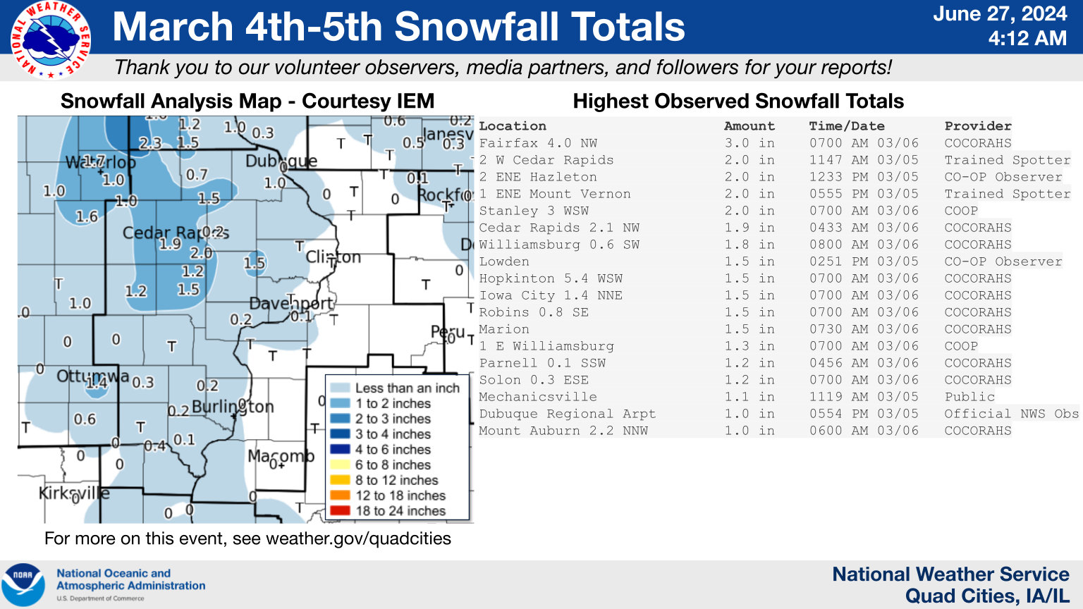
Public Information Statement
National Weather Service Quad Cities IA IL
1003 AM CST Thu Mar 6 2025

...Highest Snowfall Reports Past 48 Hours...

Observations are collected from a variety of sources with varying
equipment and exposures. We thank all volunteer weather observers
for their dedication. Not all data listed are considered official.

Location                     Amount    Time/Date       Provider
Fairfax 4.0 NW               3.0 in    0700 AM 03/06   COCORAHS
2 W Cedar Rapids             2.0 in    1147 AM 03/05   Trained Spotter
2 ENE Hazleton               2.0 in    1233 PM 03/05   CO-OP Observer
1 ENE Mount Vernon           2.0 in    0555 PM 03/05   Trained Spotter
Stanley 3 WSW                2.0 in    0700 AM 03/06   COOP
Cedar Rapids 2.1 NW          1.9 in    0433 AM 03/06   COCORAHS
Williamsburg 0.6 SW          1.8 in    0800 AM 03/06   COCORAHS
Lowden                       1.5 in    0251 PM 03/05   CO-OP Observer
Hopkinton 5.4 WSW            1.5 in    0700 AM 03/06   COCORAHS
Iowa City 1.4 NNE            1.5 in    0700 AM 03/06   COCORAHS
Robins 0.8 SE                1.5 in    0700 AM 03/06   COCORAHS
Marion                       1.5 in    0730 AM 03/06   COCORAHS
1 E Williamsburg             1.3 in    0700 AM 03/06   COOP
Parnell 0.1 SSW              1.2 in    0456 AM 03/06   COCORAHS
Solon 0.3 ESE                1.2 in    0700 AM 03/06   COCORAHS
Mechanicsville               1.1 in    1119 AM 03/05   Public
Dubuque Regional Arpt        1.0 in    0554 PM 03/05   Official NWS Obs
Mount Auburn 2.2 NNW         1.0 in    0600 AM 03/06   COCORAHS
Mean Sea Level Pressure
 |
 |
Media use of NWS Web News Stories is encouraged! NWS Quad Cities Past Events Page: weather.gov/dvn/events |
|

