|
Fast Facts
A large weather system tracked over the Midwest on March 15, initially bringing rain, thunderstorms, and even hail to the size of ping pong balls to Johnson County.
The weather system deepened rapidly to the east of the area that night, resulting in the local area seeing widespread snow, heavy at times, with frequent gusts of 40-55 mph.
The combination of falling and blowing snow brought blizzard conditions and treacherous travel.
Most area airports dropped to one half mile visibility or less, several at one quarter mile, and many for numerous hours.
Per news reports, most area schools closed, and DOTs reported all roads were completely snow covered with travel not recommended. In addition, I-80 was closed during the night of March 15 west of Iowa City through the IA / NE border.
A quick perusal of the NWS Storm Data (official database of severe and impactful weather reports), for any counties in the NWS Quad Cities County Warning Area that this event is deemed a blizzard, it could go down as the latest blizzard in a season since at least 1996 (next latest March 9, 2002).
A Blizzard Warning was issued for much of the area on March 14. This was the first Blizzard Warning for many area counties since January 2024.
This event had far-reaching impacts. See these other NWS office recaps:
Southwest Wisconsin (NWS La Crosse)
Southern Wisconsin (NWS Milwaukee)
Northeast Illinois (NWS Chicago)
Snowfall
|
Official Climate Site Totals Davenport, IA (NWS Quad Cities): 7.8" Moline, IL (Quad Cities): 7.0" Dubuque, IA: 6.3"
Public Information Statement National Weather Service Quad Cities IA IL 431 PM CDT Mon Mar 16 2026 ...Highest Snowfall Amounts from March 15-16 2026 Blizzard... We thank all volunteer weather observers for their dedication, especially considering the challenging nature of measuring snow with this event. The reports are not necessarily the final amount for each location and not all data listed are considered official. Also numerous reports were estimated due to the blowing and drifting of snow. Snow Reports Listed By Amount INCHES LOCATION ST COUNTY TIME ------ ----------------------- -- -------------- ------- 10.0 Freeport IL Stephenson 1138 AM 9.0 Lowden IA Cedar 0741 AM 8.6 Charlotte IA Clinton 0702 AM 8.5 Lanark IL Carroll 0543 AM 8.0 1 SE Davenport IA Scott 0700 AM 8.0 1 SE Camanche IA Clinton 0327 PM 7.8 Davenport Airport IA Scott 0100 PM 7.5 2 NE Davenport IA Scott 1226 PM 7.5 2 W Fulton IA Clinton 0921 AM 7.5 3 ENE Clinton IA Clinton 0700 AM 7.3 Mount Carroll IL Carroll 0845 AM 7.3 2 W Freeport IL Stephenson 0648 AM 7.2 1 NW Park View IA Scott 0745 AM 7.0 2 W Bettendorf IA Scott 0805 AM 7.0 Quad City Airport IL Rock Island 0700 PM 7.0 2 WNW Bettendorf IA Scott 0700 AM 7.0 2 N Rock Island IL Rock Island 0630 AM 7.0 2 N Credit Island IA Scott 0615 AM 6.6 1 NNE Moline IL Rock Island 0630 AM 6.5 3 NE Muscatine IA Muscatine 1050 AM 6.5 1 NW Fruitland IL Rock Island 0808 AM 6.5 Galena IL Jo Daviess 0645 AM 6.3 Dubuque Regional Arpt IA Dubuque 0100 PM 6.3 4 NNE Muscatine IA Muscatine 0700 AM 6.1 1 S Coal Valley IL Rock Island 0818 AM 6.0 1 NNE Davis IL Stephenson 0800 AM 6.0 6 SSE Elmoville IL Carroll 0745 AM 6.0 Hanover IL Jo Daviess 0700 AM 6.0 Freeport IL Stephenson 0540 AM 5.9 Green River IL Henry 0700 AM 5.9 Elizabeth IL Jo Daviess 0630 AM 5.5 1 SW Silvis IL Rock Island 0429 AM 5.0 Mount Carroll IL Carroll 0930 AM 5.0 3 W Paralta IA Linn 0857 AM 5.0 1 W Elmira IA Johnson 0842 AM 5.0 Stanwood IA Cedar 0810 AM 5.0 1 NW Maquoketa IA Jackson 0808 AM 5.0 3 N Stockton IL Jo Daviess 0800 AM 5.0 3 NNE Stockton IL Jo Daviess 0800 AM 5.0 1 NNW Monticello IA Jones 0700 AM 5.0 2 WNW Charlotte IA Clinton 0700 AM 4.8 1 SE Grandview IA Louisa 0722 AM 4.8 2 N Oakland Mills IA Henry 0900 AM 4.5 3 SW Center Junction IA Jones 0846 AM 4.4 Mount Vernon IA Linn 0900 AM 4.1 2 NW Cedar Rapids IA Linn 0610 AM 4.0 Geneseo IL Henry 1138 AM 4.0 3 ENE Charlie Heath Area MO Clark 1022 AM 4.0 2 NE Cedar Rapids IA Linn 0908 AM 4.0 2 SW Williamstown IA Johnson 0903 AM 4.0 Green Rock IL Henry 0900 AM 4.0 2 NW North Liberty IA Johnson 0816 AM 3.9 Albany IL Whiteside 0636 AM 3.8 New London IA Henry 0653 AM 3.8 Aledo IL Mercer 0630 AM 3.6 3 ESE Amber IA Louisa 0700 AM 3.5 1 NE Dundee IA Delaware 0700 AM 3.5 2 SW Yarmouth IA Des Moines 0700 AM 3.5 Ely IA Linn 0630 AM 3.2 2 E Iowa City IA Johnson 0700 AM 3.2 3 SSE Atkins IA Benton 0700 AM 3.0 2 W Cedar Rapids IA Linn 1105 AM 3.0 2 SSE Burlington Arpt IA Des Moines 1000 AM 3.0 La Harpe IL Hancock 0800 AM 3.0 2 ESE Fairview IA Jones 0700 AM 3.0 2 ENE Hiawatha IA Linn 0700 AM 3.0 1 NNE Iowa City IA Johnson 0700 AM 3.0 Solon IA Johnson 0700 AM 2.9 Tiskilwa IL Bureau 0815 AM 2.8 1 SW University Heights IA Johnson 1048 AM 2.8 2 NW Rutledge MO Scotland 0915 AM 2.8 3 W Richmond IA Washington 0530 AM 2.5 2 SW Prairieburg IA Linn 1125 AM 2.5 1 E La Harpe IL Hancock 0930 AM 2.5 1 NE Marion IA Linn 0800 AM 2.5 1 SW Perlee IA Jefferson 0734 AM 2.5 1 E Kewanee IL Henry 0700 AM 2.5 1 SE Robins IA Linn 0700 AM 2.4 1 SW Washington IA Washington 0700 AM 2.4 Donnellson IA Lee 0700 AM 2.0 Fairfield IA Jefferson 1009 AM 2.0 1 NNE Fairfield IA Jefferson 0800 AM 2.0 1 S Salem IA Henry 0700 AM 2.0 3 W Macomb IL Mcdonough 0700 AM 2.0 3 SE Iowa City Arpt IA Johnson 0700 AM 2.0 2 NNW Mount Auburn IA Benton 0600 AM 1.8 2 SE Williamsburg IA Iowa 0700 AM 1.5 1 ENE Vinton IA Benton 0800 AM 1.5 Sigourney IA Keokuk 0600 AM 1.1 1 SW Stronghurst IL Henderson 0700 AM |
Peak Gusts Observed
...HIGHEST WIND GUST REPORTS... Location Speed Time/Date Lat/Lon -------------------------------------------------------------------- Fairfield Arpt 60 MPH 0715 PM 03/15 41.03N/91.97W Cedar Rapids Arpt 54 MPH 0140 AM 03/16 41.88N/91.72W Anamosa 54 MPH 0540 AM 03/16 42.07N/91.34W Us-30 At Us-218 54 MPH 1235 AM 03/16 41.96N/92.03W Washington Arpt 53 MPH 0235 AM 03/16 41.27N/91.67W Independence Arpt 52 MPH 0215 AM 03/16 42.45N/91.95W Iowa City Arpt 52 MPH 1012 PM 03/15 41.63N/91.55W Burlington Arpt 49 MPH 0456 AM 03/16 40.77N/91.13W Dubuque Arpt 49 MPH 1122 PM 03/15 42.40N/90.70W Quad City Intl Arpt 49 MPH 0555 AM 03/16 41.45N/90.52W Urbana 48 MPH 0135 AM 03/16 42.31N/91.98W Fairfax 47 MPH 0115 AM 03/16 41.90N/91.77W MACOMB 47 MPH 0245 AM 03/16 40.37N/90.70W Davenport Arpt 47 MPH 0619 AM 03/16 41.62N/90.58W I-80 At I-380 47 MPH 0305 AM 03/16 41.69N/91.64W Macomb Arpt 46 MPH 0315 AM 03/16 40.52N/90.65W Mount Pleasant Arpt 45 MPH 0215 AM 03/16 40.95N/91.52W Cantril 45 MPH 1100 PM 03/15 40.66N/92.06W 0.7 W Belle Plaine (UPR) 45 MPH 1256 AM 03/16 41.90N/92.29W Urbana 43 MPH 0145 AM 03/16 42.22N/91.88W Keokuk Arpt 43 MPH 0355 AM 03/16 40.47N/91.42W Fort Madison Arpt 43 MPH 0323 AM 03/16 40.67N/91.32W Muscatine Arpt 43 MPH 0535 AM 03/16 41.37N/91.15W Us-30 Mt Vernon 43 MPH 0415 AM 03/16 41.91N/91.42W Cedar River Tnc Swamp 43 MPH 0546 AM 03/16 41.41N/91.32W Fairbank 42 MPH 0515 AM 03/16 42.64N/92.05W Vinton 41 MPH 0115 AM 03/16 42.12N/92.01W Independence 41 MPH 0330 AM 03/16 42.47N/91.88W Clinton Arpt 41 MPH 0724 AM 03/16 41.82N/90.32W Cedar Rapids I-380 41 MPH 0600 AM 03/16 41.98N/91.67W 0.6 W Lowden (UPR) 41 MPH 0427 AM 03/16 41.86N/90.93W BETTENDORF 40 MPH 0611 AM 03/16 41.56N/90.46W MANCHESTER 40 MPH 0530 AM 03/16 42.49N/91.48W Vinton Arpt 40 MPH 0255 AM 03/16 42.22N/92.02W Tipton 40 MPH 0440 AM 03/16 41.64N/91.13W Stockton 3 Nne 39 MPH 0800 AM 03/16 42.40N/90.00W Stronghurst 38 MPH 0304 AM 03/16 40.74N/90.91W Masonville 38 MPH 0315 AM 03/16 42.48N/91.59W Marengo 38 MPH 0205 AM 03/16 41.85N/92.00W Monmouth 38 MPH 0510 AM 03/16 40.93N/90.63W Dubuque 38 MPH 0220 AM 03/16 42.49N/90.73W Davenport 38 MPH 0610 AM 03/16 41.60N/90.68W Lone Tree (WEATHERSTEM) 37 MPH 0340 AM 03/16 41.49N/91.43W Springville 37 MPH 0325 AM 03/16 42.11N/91.44W Stockport 37 MPH 0525 AM 03/16 40.85N/91.83W Vinton 37 MPH 0115 AM 03/16 42.16N/92.04W Stockport 37 MPH 1225 AM 03/16 40.83N/91.80W BETTENDORF 37 MPH 0630 AM 03/16 41.58N/90.48W Freeport Arpt 37 MPH 0735 PM 03/15 42.25N/89.58W De Witt 37 MPH 1225 AM 03/16 41.83N/90.57W CENTRAL CITY 36 MPH 0420 AM 03/16 42.20N/91.53W Eldridge 36 MPH 0715 AM 03/16 41.66N/90.57W Stockton 36 MPH 0815 AM 03/16 42.40N/89.99W Shimek State Forest 36 MPH 0107 AM 03/16 40.65N/91.72W Cedar Rapids 36 MPH 0528 PM 03/15 41.96N/91.71W Manchester 36 MPH 0555 PM 03/15 42.47N/91.45W 2 ENE Dysart 35 MPH 1200 AM 03/16 42.19N/92.26W Dixon 35 MPH 0435 AM 03/16 41.69N/90.71W Bushnell 35 MPH 0555 AM 03/16 40.56N/90.51W Aurora 35 MPH 0415 AM 03/16 42.62N/91.73W Eldridge 35 MPH 0644 AM 03/16 41.64N/90.59W |
Radar
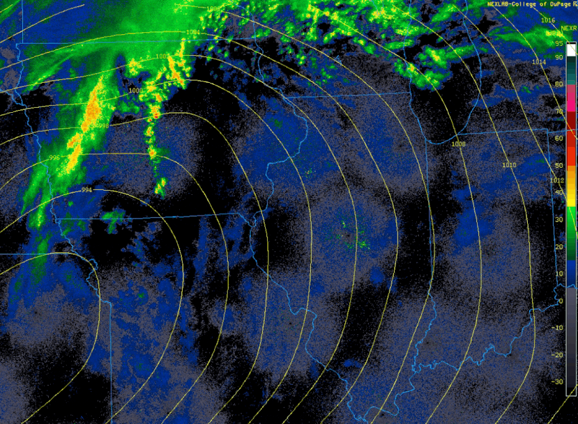 |
| March 15, 6 AM Radar - March 16, 12 PM Regional Radar & Sea Level Pressure (mb) |
Science & Service
 |
|
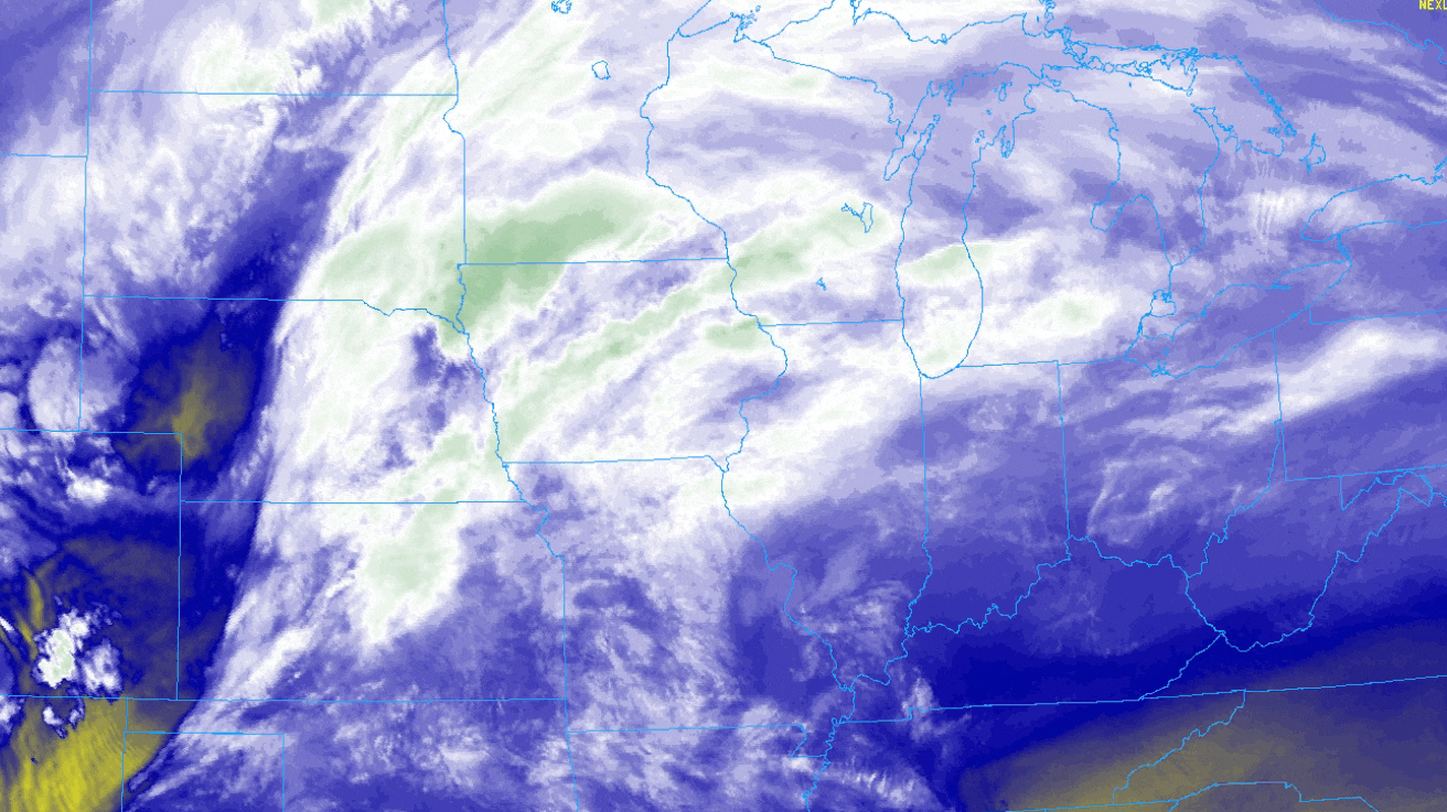
Satellite water vapor imagery from the night of March 14 through the early morning of March 16. |
 |
 |
 |
| 500 mb Heights, Temperatures, and Winds (contoured) March 15, 5 PM - 12 AM CDT Upper to mid-level jet stream, which during the evening of March 15th rapidly intensified over the area. |
Dendritic Growth Zone Depth (magenta) and RH (contoured) The dendritic growth zone (DGZ) is a temperature profile favored for higher growth and numbers of snowflakes if saturated, deep, and intersection upwards motion. |
DVN Weather Balloon Data (Sounding) At the time this balloon was launched, rain had just changed to sleet. The low-level thermal cold layer is captured on this sounding plot that caused refreezing of the once frozen hydrometeor as it fell. That cold layer was as cold as -7°C as shown here, which with a subfreezing depth of a few thousand feet was cold enough for snow. Within the hour as forcing for ascent increased, the sleet changed to snow. |
 |
 |
 |
| NWS Watch, Warning, and Advisory Map at 7:30 PM March 15 Blizzard Warning for the local area was issued on the afternoon of March 14. |
Snowfall Forecast from ~27 Hours Before Snowfall Start |
Forecast Hazard Timeline issued March 15, 4:30 AM |
 |
|
High Impact Graphicast issued on March 15, 9 PM. |
 |
Media use of NWS Web News Stories is encouraged! Please acknowledge the NWS as the source of any news information accessed from this site. |
|


