Overview
|
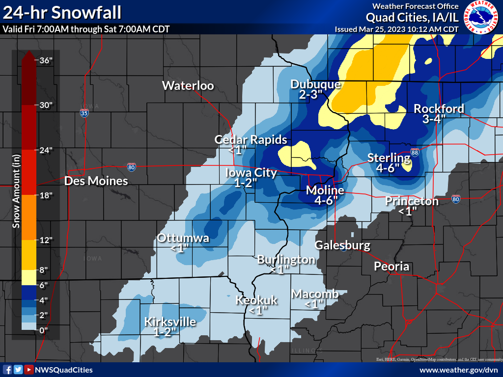
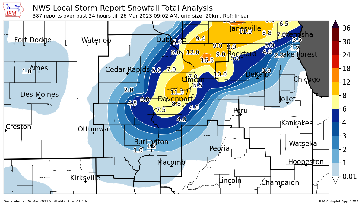
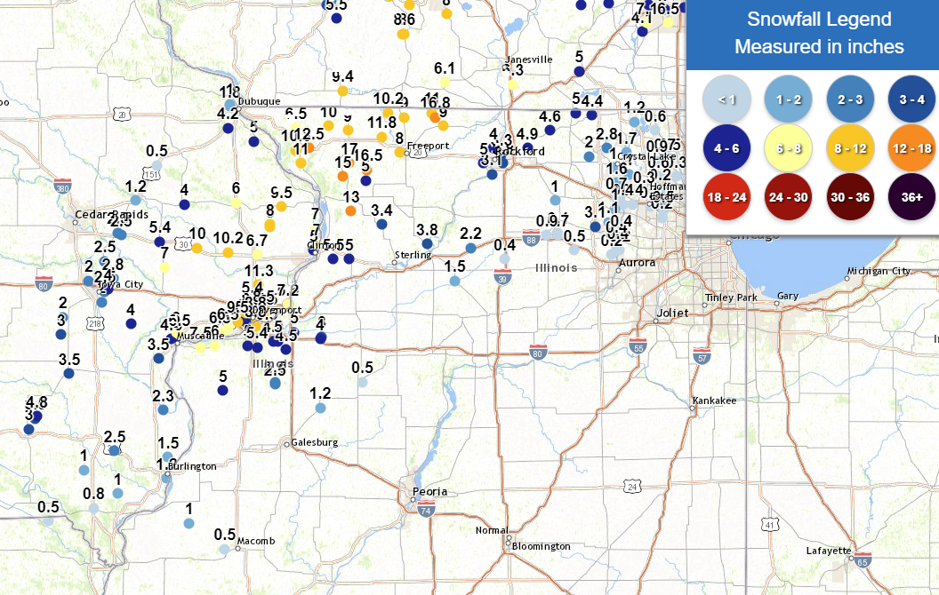
A strong winter storm brought moderate to heavy snow to portions of eastern Iowa and northwest Illinois late Friday night and early Saturday morning. Precipitation began as rain that quickly changed over to snow early Saturday. Heavy wet snow fell east of a line from Fairfield to Iowa City, to Dubuque and generally north of a line from Burlington Iowa to Galesburg Illinois. The heaviest snowfall amounts between 8 and 12 inches fell from extreme eastern Iowa in Cedar, Scott, and Clinton counties, to Carroll, Jo Daviess, and Stephenson counties in Illinois. This heavy snow caused numerous accidents and downed several tree branches due to the weight of the snow. NWS Official Totals Moline: 7.3" Notable (Non-NWS) Totals Elizabeth, IL: 12.5" (COOP Observer) |
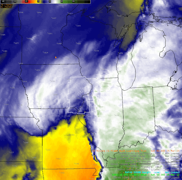
 WPC Sea Level Pressure/Fronts/Radar Loop (10p Fri - 7am Sat) |
Snow/Rain
â„ï¸ Snowfall / Rainfall Maps â„ï¸
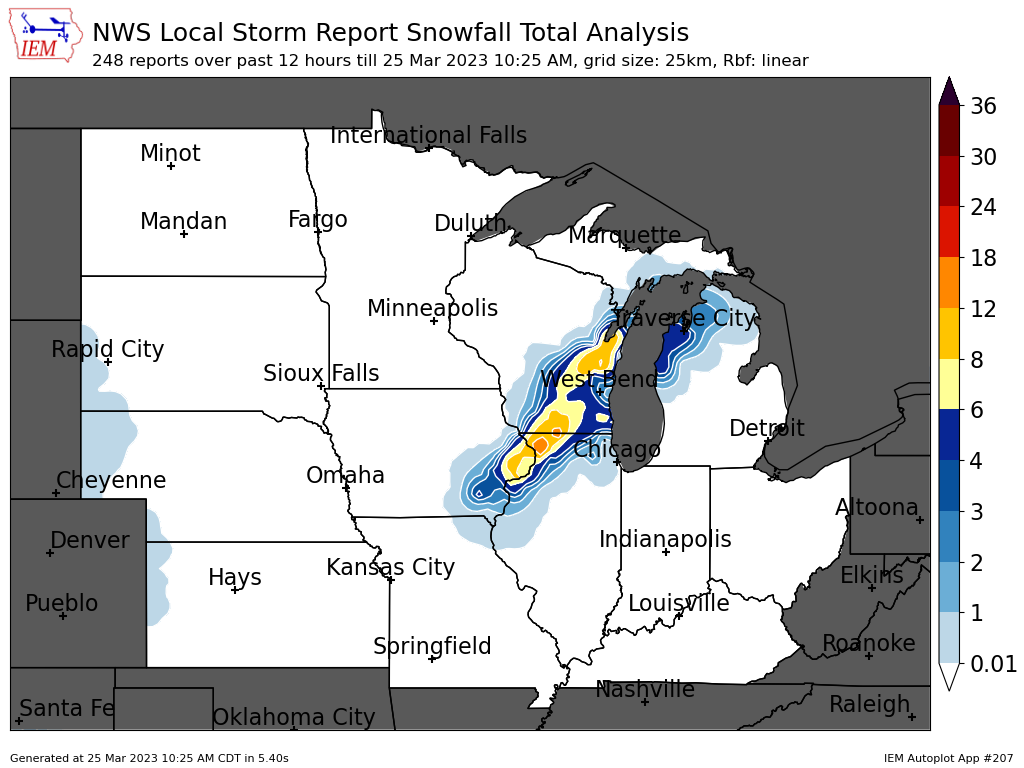
| Midwest Snowfall Analysis Courtesy Iowa Environmental Mesonet |
24-hr Local Snowfall Map |
Local Snowfall Analysis Courtesy Iowa Environmental Mesonet |
 |
 |
 |
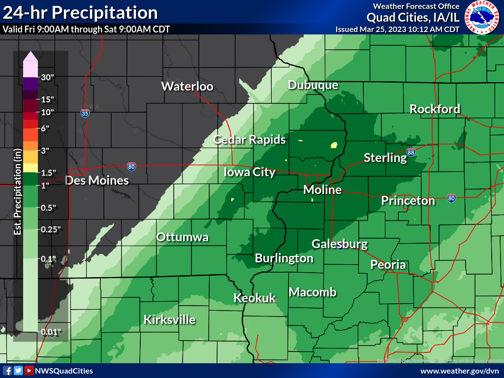
| 24-hr Local Rainfall Map Ending 8am Saturday |
||
 |
Photos
 |
 |
 |
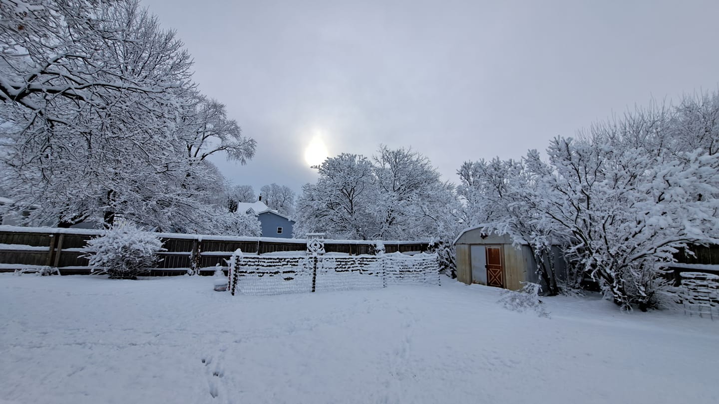
 |
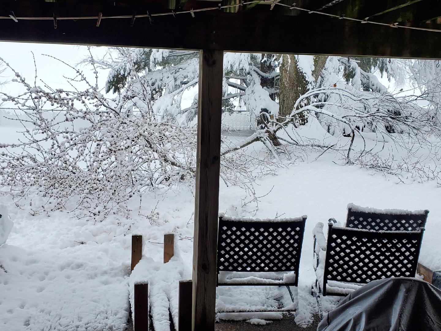
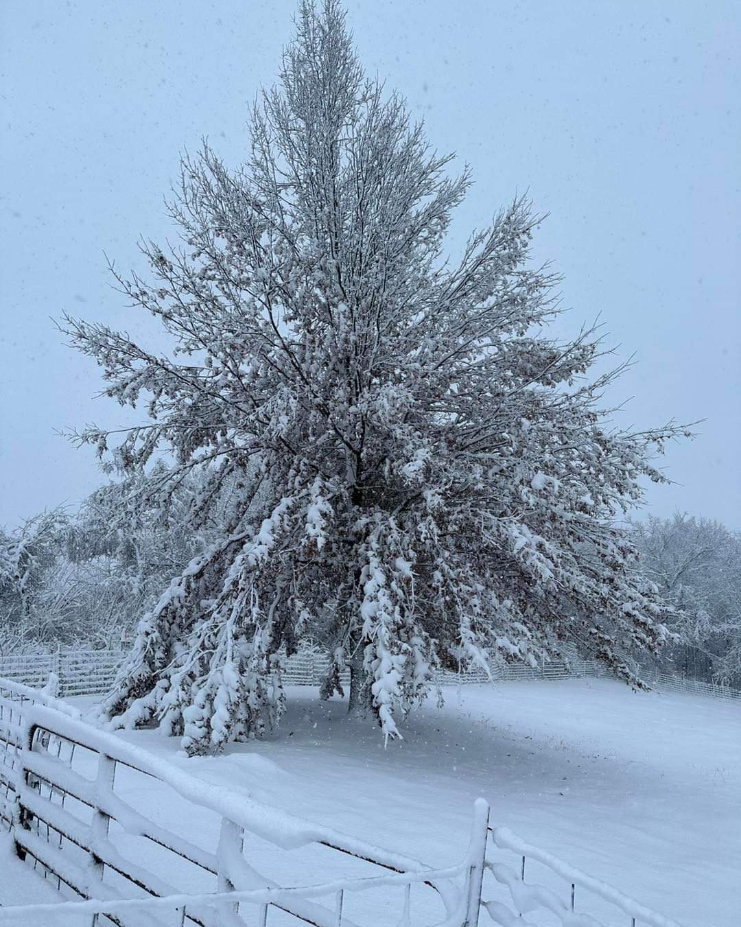
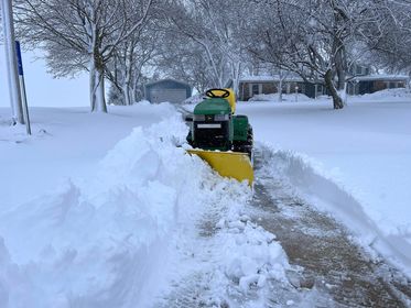
| West Liberty, IA (Jose Revelez) |
Charlotte, IA (Justin Ploog) |
Park View, IA (Andy Ervin) |
Moline, IL (Autumn Gross) |
 |
 |
 |
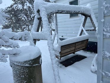
|
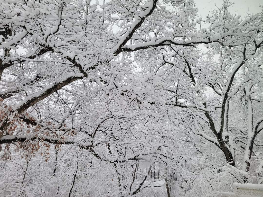
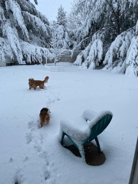
| Eldridge,IA (Mike McClure) |
Coyne Center, IL (Mark Ahrens) |
Stockton, IL (Fred Demeter) |
Storm Reports
📠Storm Reports ðŸ“
Storm Reports Map - Courtesy IEM
 |
PRELIMINARY LOCAL STORM REPORT...SUMMARY
NATIONAL WEATHER SERVICE QUAD CITIES IA IL
122 PM CDT SAT MAR 25 2023
..TIME... ...EVENT... ...CITY LOCATION... ...LAT.LON...
..DATE... ....MAG.... ..COUNTY LOCATION..ST.. ...SOURCE....
..REMARKS..
0100 PM SNOW 1 NW DUBUQUE REGIONAL A 42.41N 90.73W
03/25/2023 M4.2 INCH DUBUQUE IA OFFICIAL NWS OBS
STORM TOTAL.
1250 PM SNOW DAVENPORT AIRPORT 41.61N 90.58W
03/25/2023 M7.8 INCH SCOTT IA OFFICIAL NWS OBS
STORM TOTAL, 2.4 INCHES SINCE 7AM.
1250 PM SNOW 3 SW QUAD CITY AIRPORT 41.40N 90.55W
03/25/2023 M7.3 INCH ROCK ISLAND IL OFFICIAL NWS OBS
STORM TOTAL, 1.9 INCHES SINCE 7AM.
1230 PM SNOW 2 NE RIVERSIDE 41.51N 91.54W
03/25/2023 M4.5 INCH WASHINGTON IA TRAINED SPOTTER
STORM TOTAL.
1230 PM SNOW WYOMING 42.06N 91.00W
03/25/2023 E5.0 INCH JONES IA TRAINED SPOTTER
STORM TOTAL.
1200 PM SNOW 5 NW LANARK 42.16N 89.89W
03/25/2023 M7.0 INCH CARROLL IL TRAINED SPOTTER
STORM TOTAL.
1113 AM SNOW 2 ESE DAVENPORT 41.54N 90.56W
03/25/2023 M8.8 INCH SCOTT IA NWS EMPLOYEE
STORM TOTAL.
1113 AM SNOW PARK VIEW 41.69N 90.54W
03/25/2023 M11.3 INCH SCOTT IA NWS EMPLOYEE
STORM TOTAL.
1112 AM SNOW 2 W BETTENDORF 41.57N 90.51W
03/25/2023 M8.5 INCH SCOTT IA NWS EMPLOYEE
STORM TOTAL.
1100 AM SNOW 1 ENE MONTPELIER 41.47N 90.78W
03/25/2023 M7.6 INCH SCOTT IA TRAINED SPOTTER
STORM TOTAL.
1100 AM SNOW 3 N STOCKTON 42.40N 90.00W
03/25/2023 M10.0 INCH JO DAVIESS IL CO-OP OBSERVER
STORM TOTAL.
1100 AM SNOW 3 SW WINNESHIEK 42.32N 89.57W
03/25/2023 M9.0 INCH STEPHENSON IL TRAINED SPOTTER
STORM TOTAL.
1053 AM SNOW 4 SSE LORAN 42.17N 89.88W
03/25/2023 M7.0 INCH CARROLL IL TRAINED SPOTTER
STORM TOTAL.
1044 AM SNOW BETTENDORF 41.56N 90.48W
03/25/2023 E8.5 INCH SCOTT IA PUBLIC
STORM TOTAL.
1044 AM SNOW MAQUOKETA 42.07N 90.67W
03/25/2023 E7.0 INCH JACKSON IA PUBLIC
STORM TOTAL.
1044 AM SNOW MILLEDGEVILLE 41.97N 89.78W
03/25/2023 M4.9 INCH CARROLL IL TRAINED SPOTTER
STORM TOTAL.
1043 AM SNOW FULTON 41.86N 90.16W
03/25/2023 M4.0 INCH WHITESIDE IL TRAINED SPOTTER
STORM TOTAL.
1043 AM SNOW WALCOTT 41.59N 90.77W
03/25/2023 E8.0 INCH SCOTT IA TRAINED SPOTTER
STORM TOTAL.
1042 AM SNOW 2 S MC CONNELL 42.40N 89.74W
03/25/2023 M9.0 INCH STEPHENSON IL TRAINED SPOTTER
STORM TOTAL.
1040 AM SNOW 1 SSW NORTH LIBERTY 41.73N 91.62W
03/25/2023 M2.0 INCH JOHNSON IA TRAINED SPOTTER
STORM TOTAL.
1040 AM SNOW 2 NNW NORTH LIBERTY 41.76N 91.62W
03/25/2023 E1.2 INCH JOHNSON IA TRAINED SPOTTER
STORM TOTAL.
1039 AM SNOW MILLEDGEVILLE 41.96N 89.77W
03/25/2023 M5.0 INCH CARROLL IL TRAINED SPOTTER
STORM TOTAL.
1038 AM SNOW 2 WSW DOWNEY 41.61N 91.39W
03/25/2023 M5.0 INCH JOHNSON IA TRAINED SPOTTER
1030 AM SNOW 3 E WALCOTT 41.59N 90.72W
03/25/2023 M6.0 INCH SCOTT IA TRAINED SPOTTER
STORM TOTAL.
1020 AM SNOW DAKOTA 42.39N 89.53W
03/25/2023 M6.5 INCH STEPHENSON IL TRAINED SPOTTER
STORM TOTAL.
1018 AM SNOW 1 NW DAVENPORT 41.56N 90.62W
03/25/2023 M8.0 INCH SCOTT IA TRAINED SPOTTER
1018 AM SNOW 3 ENE GARDEN PLAIN 41.81N 90.08W
03/25/2023 M5.5 INCH WHITESIDE IL TRAINED SPOTTER
1017 AM SNOW 4 NE CLINTON 41.88N 90.18W
03/25/2023 M7.0 INCH CLINTON IA TRAINED SPOTTER
1017 AM SNOW ORANGEVILLE 42.46N 89.64W
03/25/2023 E9.0 INCH STEPHENSON IL TRAINED SPOTTER
1015 AM SNOW 1 ENE BURLINGTON REGION 40.79N 91.11W
03/25/2023 E1.2 INCH DES MOINES IA TRAINED SPOTTER
1014 AM SNOW 2 W BETTENDORF 41.56N 90.51W
03/25/2023 M8.5 INCH SCOTT IA TRAINED SPOTTER
1013 AM SNOW 2 SSE ALMONT 41.95N 90.19W
03/25/2023 M7.0 INCH CLINTON IA TRAINED SPOTTER
HEAVY WET SNOW, SMALL TREE BRANCHES DOWN.
1006 AM HEAVY RAIN CANTRIL 40.64N 92.07W
03/25/2023 M1.01 INCH VAN BUREN IA TRAINED SPOTTER
1006 AM HEAVY SNOW ILLINOIS CITY 41.40N 90.90W
03/25/2023 M7.5 INCH ROCK ISLAND IL TRAINED SPOTTER
STORM TOTAL SNOWFALL.
1004 AM SNOW 1 SSW GENESEO 41.44N 90.16W
03/25/2023 M4.0 INCH HENRY IL TRAINED SPOTTER
STORM TOTAL SNOWFALL.
1000 AM SNOW 1 ENE GREEN RIVER 41.47N 90.32W
03/25/2023 M5.0 INCH HENRY IL TRAINED SPOTTER
0947 AM SNOW WYOMING 42.06N 91.00W
03/25/2023 M4.0 INCH JONES IA EMERGENCY MNGR
0945 AM SNOW LE CLAIRE 41.60N 90.36W
03/25/2023 E7.2 INCH SCOTT IA TRAINED SPOTTER
0941 AM SNOW 1 N ELDRIDGE 41.65N 90.57W
03/25/2023 M8.5 INCH SCOTT IA TRAINED SPOTTER
STORM TOTAL.
0941 AM SNOW WEST LIBERTY 41.57N 91.26W
03/25/2023 M6.0 INCH MUSCATINE IA PUBLIC
STORM TOTAL.
0930 AM SNOW GENESEO 41.45N 90.15W
03/25/2023 M3.0 INCH HENRY IL BROADCAST MEDIA
0928 AM HEAVY SNOW 2 SW SAINT DONATUS 42.35N 90.57W
03/25/2023 M5.0 INCH JACKSON IA TRAINED SPOTTER
0911 AM SNOW 2 E WEST POINT 40.72N 91.41W
03/25/2023 M1.0 INCH LEE IA COCORAHS
COCORAHS STATION IA-LE-19 WEST POINT 2.4 E.
0909 AM HEAVY SNOW 2 NNE ROCK ISLAND 41.50N 90.56W
03/25/2023 M8.8 INCH ROCK ISLAND IL PUBLIC
0908 AM SNOW 2 ESE LORAN 42.22N 89.87W
03/25/2023 M16.5 INCH STEPHENSON IL PUBLIC
VERY LARGE TREES DOWN.
0908 AM HEAVY SNOW 2 SSW SPRING LAKE 41.49N 90.73W
03/25/2023 E6.5 INCH SCOTT IA NWS EMPLOYEE
0903 AM HEAVY SNOW 3 NW EDGINGTON 41.41N 90.81W
03/25/2023 M6.0 INCH ROCK ISLAND IL PUBLIC
0901 AM SNOW 1 W MORRISON 41.81N 89.98W
03/25/2023 M5.0 INCH WHITESIDE IL TRAINED SPOTTER
HEAVY SNOW CONTINUES.
0900 AM SNOW 1 SE DEWITT 41.82N 90.54W
03/25/2023 M10.0 INCH CLINTON IA TRAINED SPOTTER
STORM TOTAL, SEVERAL TREE BRANCHES DOWN DUE
TO WEIGHT OF SNOW.
0859 AM SNOW 2 ENE CLINTON 41.85N 90.20W
03/25/2023 M5.0 INCH CLINTON IA TRAINED SPOTTER
STILL SNOWING. LARGE BRANCH DOWN IN YARD.
0857 AM SNOW 5 SSE ELMOVILLE 42.19N 90.02W
03/25/2023 M15.0 INCH CARROLL IL PUBLIC
LARGE AMOUNTS OF TREE DAMAGE.
0853 AM HEAVY SNOW 2 WNW FREEPORT 42.30N 89.67W
03/25/2023 M8.0 INCH STEPHENSON IL TRAINED SPOTTER
3 INCH BRANCH SNAPPED.
0853 AM SNOW 2 WSW OAK GROVE 41.41N 90.61W
03/25/2023 M5.0 INCH ROCK ISLAND IL PUBLIC
0850 AM SNOW 1 ENE MOUNT VERNON 41.93N 91.41W
03/25/2023 M2.3 INCH LINN IA TRAINED SPOTTER
0846 AM SNOW 3 NE ARGO FAY 42.03N 89.97W
03/25/2023 M13.0 INCH CARROLL IL PUBLIC
SEVERAL TREES DOWN BLOCKING ROADS.
0845 AM SNOW 1 W ELMIRA 41.72N 91.44W
03/25/2023 M2.8 INCH JOHNSON IA TRAINED SPOTTER
0843 AM SNOW 2 WSW OAK GROVE 41.41N 90.61W
03/25/2023 M5.0 INCH ROCK ISLAND IL PUBLIC
0840 AM SNOW 3 NW DAVIS 42.46N 89.45W
03/25/2023 M16.8 INCH STEPHENSON IL PUBLIC
0838 AM HEAVY SNOW CHARLOTTE 41.97N 90.47W
03/25/2023 M8.0 INCH CLINTON IA FIRE DEPT/RESCUE
0837 AM HEAVY SNOW MOLINE 41.49N 90.49W
03/25/2023 M6.5 INCH ROCK ISLAND IL PUBLIC
RELAYED BY BROADCAST MEDIA.
0836 AM HEAVY SNOW 2 SW BETTENDORF 41.55N 90.50W
03/25/2023 M7.0 INCH SCOTT IA PUBLIC
BROADCAST MEDIA REPORTS 7 INCHES NEAR
BETTENDORF MIDDLE SCHOOL.
0835 AM SNOW ELIZABETH 42.32N 90.23W
03/25/2023 M12.5 INCH JO DAVIESS IL CO-OP OBSERVER
0832 AM SNOW 1 ENE GALENA TERRITORY 42.41N 90.31W
03/25/2023 E6.5 INCH JO DAVIESS IL TRAINED SPOTTER
0831 AM SNOW 1 WNW ALEDO 41.20N 90.76W
03/25/2023 M5.0 INCH MERCER IL TRAINED SPOTTER
0830 AM SNOW 4 SSE LORAN 42.17N 89.88W
03/25/2023 E5.0 INCH CARROLL IL PUBLIC
0830 AM SNOW 3 NE MUSCATINE 41.46N 91.03W
03/25/2023 M6.5 INCH MUSCATINE IA PUBLIC
0830 AM SNOW 1 WNW NORTH HANOVER 42.31N 90.31W
03/25/2023 M10.3 INCH JO DAVIESS IL PUBLIC
0830 AM SNOW 2 E SPRING LAKE 41.52N 90.67W
03/25/2023 M9.5 INCH SCOTT IA PUBLIC
0830 AM SNOW 3 SSW WILLOW 42.25N 89.98W
03/25/2023 M17.0 INCH JO DAVIESS IL PUBLIC
LARGE TREE DAMAGE WITH HAZARDOUS TRAVEL.
0822 AM SNOW CHARLOTTE 41.96N 90.47W
03/25/2023 M8.0 INCH CLINTON IA PUBLIC
0821 AM SNOW 5 ENE SCHAPVILLE 42.42N 90.11W
03/25/2023 M10.0 INCH JO DAVIESS IL PUBLIC
TREES DOWN DUE TO HEAVY, WET SNOW.
0818 AM SNOW SOLON 41.80N 91.49W
03/25/2023 M2.5 INCH JOHNSON IA TRAINED SPOTTER
0815 AM SNOW 2 NNW ELEROY 42.37N 89.78W
03/25/2023 M11.8 INCH STEPHENSON IL PUBLIC
0814 AM SNOW STANWOOD 41.89N 91.15W
03/25/2023 M5.4 INCH CEDAR IA TRAINED SPOTTER
0806 AM SNOW 1 NE LE CLAIRE 41.60N 90.36W
03/25/2023 M5.5 INCH SCOTT IA PUBLIC
0802 AM SNOW LOWDEN 41.86N 90.92W
03/25/2023 M10.0 INCH CEDAR IA CO-OP OBSERVER
STORM TOTAL SNOWFALL.
0802 AM SNOW 1 ENE MONTPELIER 41.47N 90.78W
03/25/2023 E6.5 INCH SCOTT IA TRAINED SPOTTER
0801 AM SNOW 2 SSE WARNER 41.39N 90.37W
03/25/2023 M4.5 INCH HENRY IL TRAINED SPOTTER
LIGHT SNOW CONTINUES.
0800 AM SNOW 1 NNE FAIRFIELD 41.02N 91.96W
03/25/2023 M3.0 INCH JEFFERSON IA CO-OP OBSERVER
CO-OP OBSERVER STATION FRFI4 FAIRFIELD.
0800 AM SNOW LA HARPE 40.58N 90.97W
03/25/2023 M1.0 INCH HANCOCK IL CO-OP OBSERVER
CO-OP OBSERVER STATION LAHI2 LA HARPE.
0800 AM SNOW 2 N NEW WINDSOR 41.24N 90.44W
03/25/2023 M2.5 INCH HENRY IL TRAINED SPOTTER
0758 AM SNOW 1 NW MAQUOKETA 42.07N 90.68W
03/25/2023 M6.0 INCH JACKSON IA TRAINED SPOTTER
0752 AM SNOW 3 ENE ROCK GROVE 42.48N 89.47W
03/25/2023 M11.0 INCH STEPHENSON IL PUBLIC
0749 AM SNOW HANOVER 42.25N 90.28W
03/25/2023 E11.0 INCH JO DAVIESS IL PUBLIC
0746 AM SNOW 1 NNE OAKDALE 41.71N 91.59W
03/25/2023 M2.0 INCH JOHNSON IA PUBLIC
0743 AM SNOW 2 NNW MUSCATINE 41.44N 91.08W
03/25/2023 M4.6 INCH MUSCATINE IA TRAINED SPOTTER
0743 AM SNOW 5 SSE SPERRY 40.89N 91.10W
03/25/2023 M1.5 INCH DES MOINES IA PUBLIC
0740 AM SNOW 1 SW PERLEE 41.07N 91.92W
03/25/2023 M3.5 INCH JEFFERSON IA TRAINED SPOTTER
0738 AM SNOW PRESTON 42.05N 90.40W
03/25/2023 M9.5 INCH JACKSON IA TRAINED SPOTTER
0737 AM SNOW MILLEDGEVILLE 41.97N 89.78W
03/25/2023 M3.4 INCH CARROLL IL TRAINED SPOTTER
0736 AM SNOW 1 WSW NEW LONDON 40.92N 91.43W
03/25/2023 M2.5 INCH HENRY IA TRAINED SPOTTER
0733 AM SNOW 1 NNW DEWITT 41.83N 90.55W
03/25/2023 M6.7 INCH CLINTON IA NWS EMPLOYEE
0732 AM SNOW 1 SW PERLEE 41.08N 91.91W
03/25/2023 M4.8 INCH JEFFERSON IA TRAINED SPOTTER
0730 AM SNOW 2 NE CALAMUS 41.84N 90.73W
03/25/2023 M10.2 INCH CLINTON IA COCORAHS
COCORAHS STATION IA-CN-2 CALAMUS 2.0 NE.
0719 AM SNOW 2 NNE MUSCATINE 41.45N 91.05W
03/25/2023 M5.0 INCH MUSCATINE IA AMATEUR RADIO
0718 AM SNOW 1 NNW CREDIT ISLAND 41.52N 90.62W
03/25/2023 M5.3 INCH SCOTT IA PUBLIC
0716 AM SNOW 1 S SALEM 40.83N 91.62W
03/25/2023 M1.0 INCH HENRY IA CO-OP OBSERVER
0715 AM SNOW 3 ENE CHARLIE HEATH MEM 40.59N 91.84W
03/25/2023 E0.5 INCH CLARK MO TRAINED SPOTTER
0709 AM SNOW DAVENPORT AIRPORT 41.61N 90.58W
03/25/2023 M5.4 INCH SCOTT IA OFFICIAL NWS OBS
6-HR TOTAL SINCE 1AM.
0705 AM SNOW 3 SW QUAD CITY AIRPORT 41.40N 90.55W
03/25/2023 M5.4 INCH ROCK ISLAND IL OFFICIAL NWS OBS
7 AM SNOWFALL REPORT AT QUAD CITY AIRPORT.
0703 AM SNOW 2 N CREDIT ISLAND 41.53N 90.62W
03/25/2023 M4.5 INCH SCOTT IA PUBLIC
MODERATE SNOW CONTINUES.
0700 AM SNOW 2 ESE FAIRVIEW 42.08N 91.30W
03/25/2023 M1.2 INCH JONES IA CO-OP OBSERVER
CO-OP OBSERVER STATION AMOI4 ANAMOSA 3 SSW.
0700 AM SNOW 2 W BETTENDORF 41.57N 90.51W
03/25/2023 M5.0 INCH SCOTT IA NWS EMPLOYEE
SNOWFALL THROUGH 7 AM. BRANCHES SNAPPED FROM
WEIGHT OF SNOW.
0700 AM SNOW 2 SE COAL VALLEY 41.43N 90.42W
03/25/2023 M5.0 INCH HENRY IL COCORAHS
COCORAHS STATION IL-HY-5 COAL VALLEY 1.9 SE.
0700 AM SNOW DONNELLSON 40.65N 91.56W
03/25/2023 M0.8 INCH LEE IA CO-OP OBSERVER
CO-OP OBSERVER STATION DNNI4 DONNELLSON.
0700 AM SNOW 1 WNW DUBUQUE 42.51N 90.72W
03/25/2023 M1.8 INCH DUBUQUE IA COCORAHS
COCORAHS STATION IA-DB-27 DUBUQUE 1.4 WNW.
0700 AM SNOW 1 SW PERLEE 41.08N 91.91W
03/25/2023 M4.7 INCH JEFFERSON IA COCORAHS
COCORAHS STATION IA-JF-12 FAIRFIELD 5.7 NNE.
0700 AM SNOW 3 SE IOWA CITY MUNICIPA 41.61N 91.51W
03/25/2023 M2.0 INCH JOHNSON IA CO-OP OBSERVER
CO-OP OBSERVER STATION ICYI4 IOWA CITY.
0700 AM SNOW 2 E IOWA CITY 41.66N 91.49W
03/25/2023 M2.5 INCH JOHNSON IA COCORAHS
COCORAHS STATION IA-JH-34 IOWA CITY 2.3 E.
0700 AM SNOW 1 E KEWANEE 41.24N 89.90W
03/25/2023 M0.5 INCH HENRY IL CO-OP OBSERVER
CO-OP OBSERVER STATION KEWI2 KEWANEE 1 E.
0700 AM SNOW 1 NNW MONTICELLO MUNICI 42.24N 91.17W
03/25/2023 M0.5 INCH JONES IA CO-OP OBSERVER
CO-OP OBSERVER STATION MCLI4 MONTICELLO.
0700 AM SNOW 4 NNE MUSCATINE 41.47N 91.05W
03/25/2023 M6.0 INCH MUSCATINE IA CO-OP OBSERVER
CO-OP OBSERVER STATION MSTI4 2 N MUSCATINE.
0700 AM SNOW 2 NNE NEW WINDSOR 41.23N 90.44W
03/25/2023 M2.5 INCH HENRY IL COCORAHS
COCORAHS STATION IL-HY-6 NEW WINDSOR 2.0 N.
0700 AM SNOW 2 NNW NICHOLS 41.51N 91.33W
03/25/2023 M4.0 INCH MUSCATINE IA COCORAHS
COCORAHS STATION IA-MC-21 NICHOLS 2.5 NNW.
0700 AM SNOW TIPTON 41.77N 91.12W
03/25/2023 M7.0 INCH CEDAR IA COCORAHS
COCORAHS STATION IA-CD-8 TIPTON 0.3 ESE.
0700 AM SNOW 3 ESE AMBER 41.11N 91.13W
03/25/2023 M2.3 INCH LOUISA IA COCORAHS
COCORAHS STATION IA-LS-5 WAPELLO 5.4 SE.
0700 AM SNOW 1 SW WASHINGTON 41.28N 91.71W
03/25/2023 M3.5 INCH WASHINGTON IA CO-OP OBSERVER
CO-OP OBSERVER STATION WSHI4 WASHINGTON 2
SSW.
0700 AM SNOW 3 W RICHMOND 41.46N 91.76W
03/25/2023 M3.0 INCH WASHINGTON IA COCORAHS
COCORAHS STATION IA-WS-7 WELLMAN 4.0 E.
0700 AM SNOW 2 SSW WILLIAMSTOWN 41.54N 91.75W
03/25/2023 M2.0 INCH JOHNSON IA PUBLIC
0657 AM SNOW 1 NW DUBUQUE REGIONAL A 42.41N 90.73W
03/25/2023 M4.2 INCH DUBUQUE IA OFFICIAL NWS OBS
0650 AM SNOW 3 W MACOMB 40.46N 90.75W
03/25/2023 M0.5 INCH MCDONOUGH IL COCORAHS
COCORAHS STATION IL-MCD-7 COLCHESTER 3.5 NE.
0648 AM SNOW 1 SSW MUSCATINE MUNICIP 41.35N 91.16W
03/25/2023 M3.5 INCH MUSCATINE IA TRAINED SPOTTER
0647 AM SNOW 2 WNW DUBUQUE 42.52N 90.72W
03/25/2023 M1.0 INCH DUBUQUE IA TRAINED SPOTTER
0633 AM SNOW 1 SSW COAL VALLEY 41.43N 90.45W
03/25/2023 M4.4 INCH ROCK ISLAND IL PUBLIC
0628 AM SNOW LISBON 41.92N 91.39W
03/25/2023 M2.5 INCH LINN IA PUBLIC
0628 AM SNOW 3 ESE WINSLOW 42.48N 89.74W
03/25/2023 M10.2 INCH STEPHENSON IL PUBLIC
HEAVY SNOW WAS ONGOING.
0626 AM SNOW 4 ENE IOWA CITY 41.67N 91.47W
03/25/2023 M4.0 INCH JOHNSON IA TRAINED SPOTTER
TOTAL. SNOW HAS ENDED.
0610 AM SNOW 3 NW EDGINGTON 41.41N 90.81W
03/25/2023 M4.0 INCH ROCK ISLAND IL TRAINED SPOTTER
0424 AM SNOW 1 SW PERLEE 41.08N 91.91W
03/25/2023 M3.5 INCH JEFFERSON IA TRAINED SPOTTER
0.52 INCH RAIN PRIOR TO SNOW.
&&
THE REPORTS BELOW ARE SEPARATED INTO SNOW...AND ICE AND SLEET
CATEGORIES...THEN BY AMOUNT...AND ARE NOT NECESSARILY THE
FINAL AMOUNT FOR EACH LOCATION.
SNOW REPORTS LISTED BY AMOUNT
INCHES LOCATION ST COUNTY TIME
------ ----------------------- -- -------------- -------
17.0 3 SSW WILLOW IL JO DAVIESS 0830 AM
16.8 3 NW DAVIS IL STEPHENSON 0840 AM
16.5 2 ESE LORAN IL STEPHENSON 0908 AM
15.0 5 SSE ELMOVILLE IL CARROLL 0857 AM
13.0 3 NE ARGO FAY IL CARROLL 0846 AM
12.5 ELIZABETH IL JO DAVIESS 0835 AM
11.8 2 NNW ELEROY IL STEPHENSON 0815 AM
11.3 PARK VIEW IA SCOTT 1113 AM
11.0 HANOVER IL JO DAVIESS 0749 AM
11.0 3 ENE ROCK GROVE IL STEPHENSON 0752 AM
10.3 1 WNW NORTH HANOVER IL JO DAVIESS 0830 AM
10.2 3 ESE WINSLOW IL STEPHENSON 0628 AM
10.2 2 NE CALAMUS IA CLINTON 0730 AM
10.0 LOWDEN IA CEDAR 0802 AM
10.0 5 ENE SCHAPVILLE IL JO DAVIESS 0821 AM
10.0 1 SE DEWITT IA CLINTON 0900 AM
10.0 3 N STOCKTON IL JO DAVIESS 1100 AM
9.5 PRESTON IA JACKSON 0738 AM
9.5 2 E SPRING LAKE IA SCOTT 0830 AM
9.0 ORANGEVILLE IL STEPHENSON 1017 AM
9.0 2 S MC CONNELL IL STEPHENSON 1042 AM
9.0 3 SW WINNESHIEK IL STEPHENSON 1100 AM
8.8 2 NNE ROCK ISLAND IL ROCK ISLAND 0909 AM
8.8 2 ESE DAVENPORT IA SCOTT 1113 AM
8.5 1 N ELDRIDGE IA SCOTT 0941 AM
8.5 2 W BETTENDORF IA SCOTT 1014 AM
8.5 BETTENDORF IA SCOTT 1044 AM
8.5 2 W BETTENDORF IA SCOTT 1112 AM
8.0 CHARLOTTE IA CLINTON 0822 AM
8.0 CHARLOTTE IA CLINTON 0838 AM
8.0 2 WNW FREEPORT IL STEPHENSON 0853 AM
8.0 1 NW DAVENPORT IA SCOTT 1018 AM
8.0 WALCOTT IA SCOTT 1043 AM
7.8 DAVENPORT AIRPORT IA SCOTT 1250 PM
7.6 1 ENE MONTPELIER IA SCOTT 1100 AM
7.5 ILLINOIS CITY IL ROCK ISLAND 1006 AM
7.3 3 SW QUAD CITY AIRPORT IL ROCK ISLAND 1250 PM
7.2 LE CLAIRE IA SCOTT 0945 AM
7.0 TIPTON IA CEDAR 0700 AM
7.0 2 SW BETTENDORF IA SCOTT 0836 AM
7.0 2 SSE ALMONT IA CLINTON 1013 AM
7.0 4 NE CLINTON IA CLINTON 1017 AM
7.0 MAQUOKETA IA JACKSON 1044 AM
7.0 4 SSE LORAN IL CARROLL 1053 AM
7.0 5 NW LANARK IL CARROLL 1200 PM
6.7 1 NNW DEWITT IA CLINTON 0733 AM
6.5 1 ENE MONTPELIER IA SCOTT 0802 AM
6.5 3 NE MUSCATINE IA MUSCATINE 0830 AM
6.5 1 ENE GALENA TERRITORY IL JO DAVIESS 0832 AM
6.5 MOLINE IL ROCK ISLAND 0837 AM
6.5 2 SSW SPRING LAKE IA SCOTT 0908 AM
6.5 DAKOTA IL STEPHENSON 1020 AM
6.0 4 NNE MUSCATINE IA MUSCATINE 0700 AM
6.0 1 NW MAQUOKETA IA JACKSON 0758 AM
6.0 3 NW EDGINGTON IL ROCK ISLAND 0903 AM
6.0 WEST LIBERTY IA MUSCATINE 0941 AM
6.0 3 E WALCOTT IA SCOTT 1030 AM
5.5 1 NE LE CLAIRE IA SCOTT 0806 AM
5.5 3 ENE GARDEN PLAIN IL WHITESIDE 1018 AM
5.4 3 SW QUAD CITY AIRPORT IL ROCK ISLAND 0705 AM
5.4 DAVENPORT AIRPORT IA SCOTT 0709 AM
5.4 STANWOOD IA CEDAR 0814 AM
5.3 1 NNW CREDIT ISLAND IA SCOTT 0718 AM
5.0 2 SE COAL VALLEY IL HENRY 0700 AM
5.0 2 W BETTENDORF IA SCOTT 0700 AM
5.0 2 NNE MUSCATINE IA MUSCATINE 0719 AM
5.0 4 SSE LORAN IL CARROLL 0830 AM
5.0 1 WNW ALEDO IL MERCER 0831 AM
5.0 2 WSW OAK GROVE IL ROCK ISLAND 0843 AM
5.0 2 WSW OAK GROVE IL ROCK ISLAND 0853 AM
5.0 2 ENE CLINTON IA CLINTON 0859 AM
5.0 1 W MORRISON IL WHITESIDE 0901 AM
5.0 2 SW SAINT DONATUS IA JACKSON 0928 AM
5.0 1 ENE GREEN RIVER IL HENRY 1000 AM
5.0 2 WSW DOWNEY IA JOHNSON 1038 AM
5.0 MILLEDGEVILLE IL CARROLL 1039 AM
5.0 WYOMING IA JONES 1230 PM
4.9 MILLEDGEVILLE IL CARROLL 1044 AM
4.8 1 SW PERLEE IA JEFFERSON 0732 AM
4.7 1 SW PERLEE IA JEFFERSON 0700 AM
4.6 2 NNW MUSCATINE IA MUSCATINE 0743 AM
4.5 2 N CREDIT ISLAND IA SCOTT 0703 AM
4.5 2 SSE WARNER IL HENRY 0801 AM
4.5 2 NE RIVERSIDE IA WASHINGTON 1230 PM
4.4 1 SSW COAL VALLEY IL ROCK ISLAND 0633 AM
4.2 1 NW DUBUQUE REGIONAL A IA DUBUQUE 0657 AM
4.2 1 NW DUBUQUE REGIONAL A IA DUBUQUE 0100 PM
4.0 3 NW EDGINGTON IL ROCK ISLAND 0610 AM
4.0 4 ENE IOWA CITY IA JOHNSON 0626 AM
4.0 2 NNW NICHOLS IA MUSCATINE 0700 AM
4.0 WYOMING IA JONES 0947 AM
4.0 1 SSW GENESEO IL HENRY 1004 AM
4.0 FULTON IL WHITESIDE 1043 AM
3.5 1 SW PERLEE IA JEFFERSON 0424 AM
3.5 1 SSW MUSCATINE MUNICIP IA MUSCATINE 0648 AM
3.5 1 SW WASHINGTON IA WASHINGTON 0700 AM
3.5 1 SW PERLEE IA JEFFERSON 0740 AM
3.4 MILLEDGEVILLE IL CARROLL 0737 AM
3.0 3 W RICHMOND IA WASHINGTON 0700 AM
3.0 1 NNE FAIRFIELD IA JEFFERSON 0800 AM
3.0 GENESEO IL HENRY 0930 AM
2.8 1 W ELMIRA IA JOHNSON 0845 AM
2.5 LISBON IA LINN 0628 AM
2.5 2 NNE NEW WINDSOR IL HENRY 0700 AM
2.5 2 E IOWA CITY IA JOHNSON 0700 AM
2.5 1 WSW NEW LONDON IA HENRY 0736 AM
2.5 2 N NEW WINDSOR IL HENRY 0800 AM
2.5 SOLON IA JOHNSON 0818 AM
2.3 3 ESE AMBER IA LOUISA 0700 AM
2.3 1 ENE MOUNT VERNON IA LINN 0850 AM
2.0 2 SSW WILLIAMSTOWN IA JOHNSON 0700 AM
2.0 3 SE IOWA CITY MUNICIPA IA JOHNSON 0700 AM
2.0 1 NNE OAKDALE IA JOHNSON 0746 AM
2.0 1 SSW NORTH LIBERTY IA JOHNSON 1040 AM
1.8 1 WNW DUBUQUE IA DUBUQUE 0700 AM
1.5 5 SSE SPERRY IA DES MOINES 0743 AM
1.2 2 ESE FAIRVIEW IA JONES 0700 AM
1.2 1 ENE BURLINGTON REGION IA DES MOINES 1015 AM
1.2 2 NNW NORTH LIBERTY IA JOHNSON 1040 AM
1.0 2 WNW DUBUQUE IA DUBUQUE 0647 AM
1.0 1 S SALEM IA HENRY 0716 AM
1.0 LA HARPE IL HANCOCK 0800 AM
1.0 2 E WEST POINT IA LEE 0911 AM
0.8 DONNELLSON IA LEE 0700 AM
0.5 3 W MACOMB IL MCDONOUGH 0650 AM
0.5 1 NNW MONTICELLO MUNICI IA JONES 0700 AM
0.5 1 E KEWANEE IL HENRY 0700 AM
0.5 3 ENE CHARLIE HEATH MEM MO CLARK 0715 AM
Environment
 |
 |
|
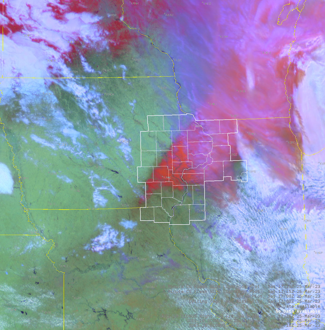
| Figure 1: Water Vapor Loop of Upper Low | Figure 2: GOES 16 Day Snow RGB Satellite Image at 1215 pm (Red = Snow) |
 |
Media use of NWS Web News Stories is encouraged! Please acknowledge the NWS as the source of any news information accessed from this site. |
|