Overview
|
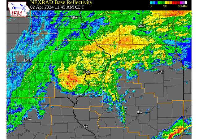
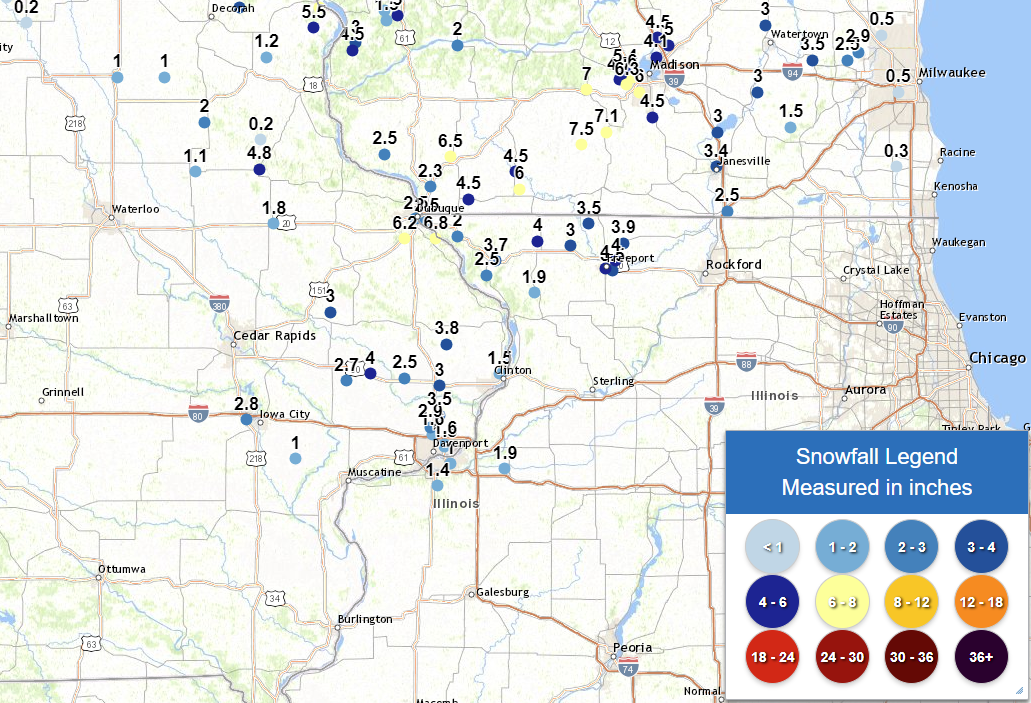
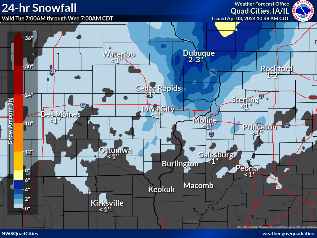
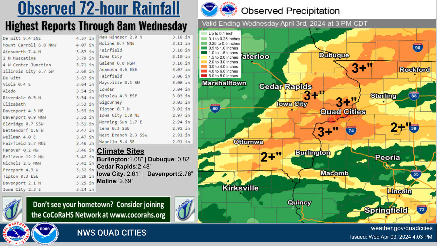
A strong system brought a mix of heavy rain, snow, and strong winds to all of eastern Iowa, northwest Illinois and northeast Missouri on the days of April 1- 3, 2024. Precipitation began as all rain during the morning of April 2nd, but quickly changed to a moderate to heavy snow by early afternoon as colder air moved into the area. Snow amounts between 2-4 inches were observed across portions of eastern Iowa, with widespread rainfall amounts of 1-3 inches. Areas of light to moderate snow and rain continued into April 3rd, with snowfall totals around 3-5 inches mainly along and north of Highway 30 in eastern Iowa and northwest Illinois. A snowfall amount of 6.8 inches was observed in eastern Dubuque county. In addition, strong northwest winds accompanied the system on April 3rd. Maximum wind gusts around 35-45 MPH were observed. NWS Official Totals |
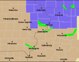 Watch, Warning, Advisory Map - 8am April 3rd, 2024 |
Snow/Ice
| Snowfall Reports | Local Snowfall Map | Regional Snowfall | |
 |
 |
.png) |
|
SNOW REPORTS LISTED BY AMOUNT

 INCHES  LOCATION                 ST  COUNTY           TIME
 ------  -----------------------  --  --------------   -------
  6.8    2 E KING                 IA  DUBUQUE          0735 AM
  6.5    DUBUQUE REGIONAL ARPT    IA  DUBUQUE          0700 PM
  4.0    3 SW WINNESHIEK          IL  STEPHENSON       0834 AM
  4.0    FREEPORT                 IL  STEPHENSON       0745 AM
  4.0    3 N STOCKTON             IL  JO DAVIESS       0735 AM
  4.0    LOWDEN                   IA  CEDAR            0700 AM
  3.9    DAKOTA                   IL  STEPHENSON       0805 AM
  3.8    2 WNW CHARLOTTE          IA  CLINTON          0700 AM
  3.7    ELIZABETH                IL  JO DAVIESS       0630 AM
  3.5    2 N FREEPORT ALBERTUS    IL  STEPHENSON       1231 PM
  3.5    PARK VIEW                IA  SCOTT            0700 AM
  3.5    3 NNE MC CONNELL         IL  STEPHENSON       0700 AM
  3.0    1 SSE DEWITT             IA  CLINTON          0800 AM
  3.0    3 W CENTER JUNCTION      IA  JONES            0800 AM
  3.0    LENA                     IL  STEPHENSON       0700 AM
  2.9    1 NW ELDRIDGE            IA  SCOTT            0700 AM
  2.8    1 S CORALVILLE           IA  JOHNSON          0800 AM
  2.7    4 S CLARENCE             IA  CEDAR            0700 AM
  2.5    1 SE DUBUQUE             IA  DUBUQUE          0730 AM
  2.5    2 NE CALAMUS             IA  CLINTON          0700 AM
  2.5    2 SE EAST DUBUQUE        IL  JO DAVIESS       0700 AM
  2.5    HANOVER                  IL  JO DAVIESS       0700 AM
  2.0    GALENA                   IL  JO DAVIESS       0917 PM
  1.9    6 SSE ELMOVILLE          IL  CARROLL          0730 AM
  1.9    2 NW GENESEO             IL  HENRY            0500 AM
  1.8    1 SSE MANCHESTER         IA  DELAWARE         0700 AM
  1.6    DAVENPORT AIRPORT        IA  SCOTT            0142 PM
  1.6    2 WNW BETTENDORF         IA  SCOTT            0700 AM
  1.5    2 W BETTENDORF           IA  SCOTT            0730 AM
  1.5    2 NE CLINTON             IA  CLINTON          0600 AM
  1.4    QUAD CITY AIRPORT        IL  ROCK ISLAND      0142 PM
  1.0    1 NNE MOLINE             IL  ROCK ISLAND      0800 AM
  1.0    2 NNW NICHOLS            IA  MUSCATINE        0700 AM
Wind Reports
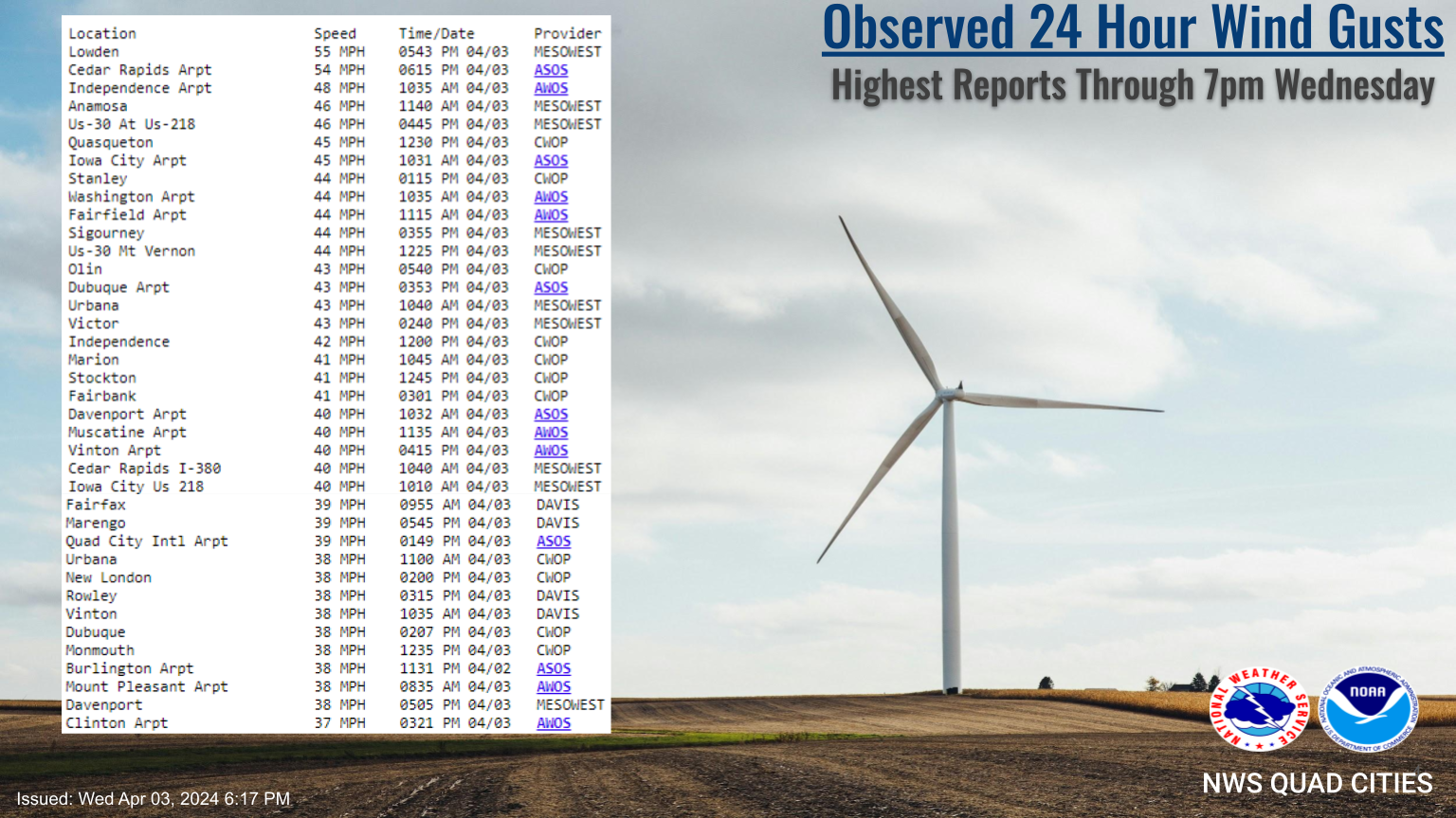 |
Public Information Statement
National Weather Service Quad Cities IA IL
711 PM CDT Wed Apr 3 2024

...Highest Wind Reports Past 24 Hours...

Observations are collected from a variety of sources with varying
equipment and exposures. We thank all volunteer weather observers
for their dedication. Not all data listed are considered official.

Location                     Speed     Time/Date       Provider
Lowden                       55 MPH    0543 PM 04/03   MESOWEST
Cedar Rapids Arpt            54 MPH    0615 PM 04/03   ASOS
Independence Arpt            48 MPH    1035 AM 04/03   AWOS
Anamosa                      46 MPH    1140 AM 04/03   MESOWEST
Us-30 At Us-218              46 MPH    0445 PM 04/03   MESOWEST
Quasqueton                   45 MPH    1230 PM 04/03   CWOP
Iowa City Arpt               45 MPH    1031 AM 04/03   ASOS
Stanley                      44 MPH    0115 PM 04/03   CWOP
Washington Arpt              44 MPH    1035 AM 04/03   AWOS
Fairfield Arpt               44 MPH    1115 AM 04/03   AWOS
Sigourney                    44 MPH    0355 PM 04/03   MESOWEST
Us-30 Mt Vernon              44 MPH    1225 PM 04/03   MESOWEST
Olin                         43 MPH    0540 PM 04/03   CWOP
Dubuque Arpt                 43 MPH    0353 PM 04/03   ASOS
Urbana                       43 MPH    1040 AM 04/03   MESOWEST
Victor                       43 MPH    0240 PM 04/03   MESOWEST
Independence                 42 MPH    1200 PM 04/03   CWOP
Marion                       41 MPH    1045 AM 04/03   CWOP
Stockton                     41 MPH    1245 PM 04/03   CWOP
Fairbank                     41 MPH    0301 PM 04/03   CWOP
Davenport Arpt               40 MPH    1032 AM 04/03   ASOS
Muscatine Arpt               40 MPH    1135 AM 04/03   AWOS
Vinton Arpt                  40 MPH    0415 PM 04/03   AWOS
Cedar Rapids I-380           40 MPH    1040 AM 04/03   MESOWEST
Iowa City Us 218             40 MPH    1010 AM 04/03   MESOWEST
Fairfax                      39 MPH    0955 AM 04/03   DAVIS
Marengo                      39 MPH    0545 PM 04/03   DAVIS
Quad City Intl Arpt          39 MPH    0149 PM 04/03   ASOS
Urbana                       38 MPH    1100 AM 04/03   CWOP
New London                   38 MPH    0200 PM 04/03   CWOP
Rowley                       38 MPH    0315 PM 04/03   DAVIS
Vinton                       38 MPH    1035 AM 04/03   DAVIS
Dubuque                      38 MPH    0207 PM 04/03   CWOP
Monmouth                     38 MPH    1235 PM 04/03   CWOP
Burlington Arpt              38 MPH    1131 PM 04/02   ASOS
Mount Pleasant Arpt          38 MPH    0835 AM 04/03   AWOS
Davenport                    38 MPH    0505 PM 04/03   MESOWEST
Clinton Arpt                 37 MPH    0321 PM 04/03   AWOS
Macomb Arpt                  37 MPH    0335 PM 04/03   AWOS
I-80 At I-380                37 MPH    0840 AM 04/03   MESOWEST
Lamont                       36 MPH    1155 AM 04/03   DAVIS
Vinton                       36 MPH    0425 PM 04/03   DAVIS
Winthrop                     36 MPH    0915 AM 04/03   CWOP
Riverside                    36 MPH    0700 AM 04/03   CWOP
Eldridge                     36 MPH    0127 PM 04/03   CWOP
Freeport Arpt                36 MPH    1215 PM 04/03   AWOS
Stockton 3 Nne               36 MPH    0735 AM 04/03   COOP
Mechanicsville               35 MPH    1140 AM 04/03   DAVIS
Macomb                       35 MPH    1158 AM 04/03   CWOP
Cantril                      35 MPH    1255 PM 04/03   MESOWEST
De Witt                      35 MPH    0555 PM 04/03   MESOWEST
Tipton                       35 MPH    1240 PM 04/03   MESOWEST
Storm Reports
📠Storm Reports ðŸ“
Storm Reports Map - Courtesy IEM
 |
PRELIMINARY LOCAL STORM REPORT...SUMMARY
NATIONAL WEATHER SERVICE QUAD CITIES IA IL
829 PM CDT WED APR 3 2024

..TIME...   ...EVENT...      ...CITY LOCATION...     ...LAT.LON...
..DATE...   ....MAG....      ..COUNTY LOCATION..ST.. ...SOURCE....
            ..REMARKS..

0735 AM     SNOW             2 E KING                42.41N 90.56W
04/03/2024  M6.8 INCH        DUBUQUE            IA   COCORAHS

            COCORAHS STATION IA-DB-31 BELLEVUE 12.2 NW.

0700 PM     SNOW             DUBUQUE REGIONAL ARPT   42.41N 90.73W
04/03/2024  M6.5 INCH        DUBUQUE            IA   OFFICIAL NWS OBS

            STORM TOTAL, 0.3 TENTHS FELL AFTER 1 PM.
            SNOW QUICKLY MELTING.

0700 AM     SNOW             LOWDEN                  41.86N 90.92W
04/03/2024  M4.0 INCH        CEDAR              IA   CO-OP OBSERVER

            STORM TOTAL FROM 1ST EVENT.

0735 AM     SNOW             3 N STOCKTON            42.40N 90.00W
04/03/2024  M4.0 INCH        JO DAVIESS         IL   CO-OP OBSERVER

            CO-OP OBSERVER STATION STOI2 STOCKTON 3 NNE.

0745 AM     SNOW             FREEPORT                42.29N 89.63W
04/03/2024  M4.0 INCH        STEPHENSON         IL   TRAINED SPOTTER

            STORM TOTAL AS OF 745A.

0834 AM     SNOW             3 SW WINNESHIEK         42.32N 89.57W
04/03/2024  M4.0 INCH        STEPHENSON         IL   TRAINED SPOTTER


0805 AM     SNOW             DAKOTA                  42.39N 89.53W
04/03/2024  M3.9 INCH        STEPHENSON         IL   PUBLIC

            RELAYED FROM BROADCAST MEDIA.

0700 AM     SNOW             2 WNW CHARLOTTE         41.98N 90.50W
04/03/2024  M3.8 INCH        CLINTON            IA   COCORAHS

            COCORAHS STATION IA-CN-17 CHARLOTTE 1.9 WNW.

0630 AM     SNOW             ELIZABETH               42.32N 90.23W
04/03/2024  M3.7 INCH        JO DAVIESS         IL   CO-OP OBSERVER

            CO-OP OBSERVER STATION EZBI2 ELIZABETH.

0700 AM     SNOW             3 NNE MC CONNELL        42.47N 89.72W
04/03/2024  M3.5 INCH        STEPHENSON         IL   COCORAHS

            COCORAHS STATION IL-SP-8 WINSLOW 4.3 ESE.

0700 AM     SNOW             PARK VIEW               41.69N 90.54W
04/03/2024  M3.5 INCH        SCOTT              IA   COCORAHS

            COCORAHS STATION IA-ST-3 PARK VIEW 0.2 WSW.

1231 PM     SNOW             2 N FREEPORT ALBERTUS   42.28N 89.59W
04/03/2024  M3.5 INCH        STEPHENSON         IL   PUBLIC

            STORM TOTAL.

0700 AM     SNOW             LENA                    42.38N 89.82W
04/03/2024  M3.0 INCH        STEPHENSON         IL   COCORAHS

            COCORAHS STATION IL-SP-31 LENA 0.3 SSE.

0800 AM     SNOW             3 W CENTER JUNCTION     42.11N 91.14W
04/03/2024  M3.0 INCH        JONES              IA   COCORAHS

            COCORAHS STATION IA-JN-10 CENTER JUNCTION
            2.6 W.

0800 AM     SNOW             1 SSE DEWITT            41.81N 90.54W
04/03/2024  M3.0 INCH        CLINTON            IA   CO-OP OBSERVER

            CO-OP OBSERVER STATION DWTI4 DE WITT.

0700 AM     SNOW             1 NW ELDRIDGE           41.64N 90.59W
04/03/2024  M2.9 INCH        SCOTT              IA   COCORAHS

            COCORAHS STATION IA-ST-30 ELDRIDGE 0.7 SSW.

0800 AM     SNOW             1 S CORALVILLE          41.67N 91.60W
04/03/2024  M2.8 INCH        JOHNSON            IA   COCORAHS

            COCORAHS STATION IA-JH-20 CORALVILLE 1.4 S.

0700 AM     SNOW             4 S CLARENCE            41.83N 91.05W
04/03/2024  M2.7 INCH        CEDAR              IA   COCORAHS

            COCORAHS STATION IA-CD-10 CLARENCE 3.9 S.

0700 AM     SNOW             HANOVER                 42.26N 90.28W
04/03/2024  M2.5 INCH        JO DAVIESS         IL   COCORAHS

            COCORAHS STATION IL-JD-6 HANOVER 0.2 NW.

0700 AM     SNOW             2 SE EAST DUBUQUE       42.48N 90.61W
04/03/2024  M2.5 INCH        JO DAVIESS         IL   COCORAHS

            COCORAHS STATION IL-JD-11 EAST DUBUQUE 1.7
            SE.

0700 AM     SNOW             2 NE CALAMUS            41.84N 90.73W
04/03/2024  M2.5 INCH        CLINTON            IA   COCORAHS

            COCORAHS STATION IA-CN-2 CALAMUS 2.0 NE.

0730 AM     SNOW             1 SE DUBUQUE            42.49N 90.67W
04/03/2024  M2.5 INCH        DUBUQUE            IA   COCORAHS

            COCORAHS STATION IA-DB-23 DUBUQUE 1.0 SE.

0700 AM     RAIN             1 NW ELDRIDGE           41.64N 90.59W
04/03/2024  M2.49 INCH       SCOTT              IA   COCORAHS

            COCORAHS STATION IA-ST-30 ELDRIDGE 0.7 SSW.

0500 AM     RAIN             3 NNE BOLTON            42.29N 89.72W
04/03/2024  M2.39 INCH       STEPHENSON         IL   COCORAHS

            COCORAHS STATION IL-SP-28 FREEPORT 4.3 W.

0700 AM     RAIN             3 NNE MC CONNELL        42.47N 89.72W
04/03/2024  M2.21 INCH       STEPHENSON         IL   COCORAHS

            COCORAHS STATION IL-SP-8 WINSLOW 4.3 ESE.

0700 AM     RAIN             HANOVER                 42.26N 90.28W
04/03/2024  M2.21 INCH       JO DAVIESS         IL   COCORAHS

            COCORAHS STATION IL-JD-6 HANOVER 0.2 NW.

0700 AM     RAIN             1 SE DAVENPORT          41.54N 90.59W
04/03/2024  M2.08 INCH       SCOTT              IA   COCORAHS

            COCORAHS STATION IA-ST-37 DAVENPORT 0.9 WNW.

0700 AM     RAIN             2 WNW BETTENDORF        41.57N 90.51W
04/03/2024  M2.06 INCH       SCOTT              IA   COCORAHS

            COCORAHS STATION IA-ST-65 DAVENPORT 4.3 NE.

0700 AM     RAIN             4 S CLARENCE            41.83N 91.05W
04/03/2024  M2.01 INCH       CEDAR              IA   COCORAHS

            COCORAHS STATION IA-CD-10 CLARENCE 3.9 S.

0700 AM     RAIN             4 NNE MUSCATINE         41.47N 91.05W
04/03/2024  M2.01 INCH       MUSCATINE          IA   CO-OP OBSERVER

            CO-OP OBSERVER STATION MSTI4 2 N MUSCATINE.

0917 PM     SNOW             GALENA                  42.42N 90.44W
04/02/2024  M2.0 INCH        JO DAVIESS         IL   TRAINED SPOTTER


0730 AM     RAIN             2 W BETTENDORF          41.56N 90.51W
04/03/2024  M2.00 INCH       SCOTT              IA   COCORAHS

            COCORAHS STATION IA-ST-48 BETTENDORF 1.6 W.

0600 AM     RAIN             1 NW DUBUQUE REGIONAL A 42.41N 90.73W
04/03/2024  M1.99 INCH       DUBUQUE            IA   CO-OP OBSERVER

            CO-OP OBSERVER STATION DUBI4 DUBUQUE 7 SSW.

0700 AM     RAIN             2 WNW CHARLOTTE         41.98N 90.50W
04/03/2024  M1.95 INCH       CLINTON            IA   COCORAHS

            COCORAHS STATION IA-CN-17 CHARLOTTE 1.9 WNW.

0500 AM     SNOW             2 NW GENESEO            41.47N 90.18W
04/03/2024  M1.9 INCH        HENRY              IL   COCORAHS

            COCORAHS STATION IL-HY-8 GENESEO 2.0 NW.

0730 AM     SNOW             6 SSE ELMOVILLE         42.19N 90.02W
04/03/2024  M1.9 INCH        CARROLL            IL   COCORAHS

            COCORAHS STATION IL-CR-12 MOUNT CARROLL 6.8
            NNW.

0700 AM     RAIN             2 NNW NICHOLS           41.51N 91.33W
04/03/2024  M1.85 INCH       MUSCATINE          IA   COCORAHS

            COCORAHS STATION IA-MC-21 NICHOLS 2.5 NNW.

1231 PM     RAIN             1 W DUBUQUE             42.51N 90.72W
04/03/2024  M1.83 INCH       DUBUQUE            IA   TRAINED SPOTTER

            TOTAL LIQUID FROM RAIN AND SNOW.

0700 AM     SNOW             1 SSE MANCHESTER        42.47N 91.45W
04/03/2024  M1.8 INCH        DELAWARE           IA   CO-OP OBSERVER

            CO-OP OBSERVER STATION MHRI4 MANCHESTER.

0600 AM     RAIN             1 NNW MONTICELLO MUNICI 42.24N 91.17W
04/03/2024  M1.75 INCH       JONES              IA   CO-OP OBSERVER

            CO-OP OBSERVER STATION MCLI4 MONTICELLO.

0800 AM     RAIN             3 W CENTER JUNCTION     42.11N 91.14W
04/03/2024  M1.75 INCH       JONES              IA   COCORAHS

            COCORAHS STATION IA-JN-10 CENTER JUNCTION
            2.6 W.

0700 AM     RAIN             LENA                    42.38N 89.82W
04/03/2024  M1.71 INCH       STEPHENSON         IL   COCORAHS

            COCORAHS STATION IL-SP-31 LENA 0.3 SSE.

0700 AM     RAIN             WAPELLO                 41.17N 91.19W
04/03/2024  M1.70 INCH       LOUISA             IA   COCORAHS

            COCORAHS STATION IA-LS-3 WAPELLO 0.2 S.

0700 AM     RAIN             1 N RIVERDALE           41.54N 90.47W
04/03/2024  M1.69 INCH       SCOTT              IA   COCORAHS

            COCORAHS STATION IA-ST-42 RIVERDALE 0.5 N.

0700 AM     RAIN             PARK VIEW               41.69N 90.54W
04/03/2024  M1.66 INCH       SCOTT              IA   COCORAHS

            COCORAHS STATION IA-ST-3 PARK VIEW 0.2 WSW.

0700 AM     RAIN             2 NE CALAMUS            41.84N 90.73W
04/03/2024  M1.65 INCH       CLINTON            IA   COCORAHS

            COCORAHS STATION IA-CN-2 CALAMUS 2.0 NE.

0600 AM     RAIN             2 NNW DOWNEY            41.64N 91.37W
04/03/2024  M1.60 INCH       JOHNSON            IA   COCORAHS

            COCORAHS STATION IA-JH-38 WEST BRANCH 2.3
            SSW.

0700 AM     SNOW             2 WNW BETTENDORF        41.57N 90.51W
04/03/2024  M1.6 INCH        SCOTT              IA   COCORAHS

            COCORAHS STATION IA-ST-65 DAVENPORT 4.3 NE.

0142 PM     SNOW             DAVENPORT AIRPORT       41.61N 90.58W
04/03/2024  M1.6 INCH        SCOTT              IA   OFFICIAL NWS OBS

            SNOW TOTAL SO FAR, 0.1 INCHES OF NEW SNOW
            SINCE 700A.

0800 AM     RAIN             1 N TIPTON              41.78N 91.13W
04/03/2024  M1.57 INCH       CEDAR              IA   COCORAHS

            COCORAHS STATION IA-CD-6 TIPTON 0.7 N.

0700 AM     RAIN             2 E IOWA CITY           41.66N 91.49W
04/03/2024  M1.56 INCH       JOHNSON            IA   COCORAHS

            COCORAHS STATION IA-JH-34 IOWA CITY 2.3 E.

0600 AM     SNOW             2 NE CLINTON            41.86N 90.21W
04/03/2024  M1.5 INCH        CLINTON            IA   COCORAHS

            COCORAHS STATION IA-CN-22 CLINTON 1.7 NNW.

0730 AM     SNOW             2 W BETTENDORF          41.56N 90.51W
04/03/2024  M1.5 INCH        SCOTT              IA   COCORAHS

            COCORAHS STATION IA-ST-48 BETTENDORF 1.6 W.

0700 AM     RAIN             1 NE IOWA CITY          41.67N 91.52W
04/03/2024  M1.49 INCH       JOHNSON            IA   COCORAHS

            COCORAHS STATION IA-JH-39 IOWA CITY 1.0 NE.

0800 AM     RAIN             2 NNW WARNER            41.45N 90.40W
04/03/2024  M1.46 INCH       HENRY              IL   COCORAHS

            COCORAHS STATION IL-HY-15 COAL VALLEY 2.6 E.

0830 AM     RAIN             DAVIS                   42.43N 89.42W
04/03/2024  M1.43 INCH       STEPHENSON         IL   COCORAHS

            COCORAHS STATION IL-SP-7 DAVIS 0.5 N.

0700 AM     RAIN             1 SW WASHINGTON         41.28N 91.71W
04/03/2024  M1.40 INCH       WASHINGTON         IA   CO-OP OBSERVER

            CO-OP OBSERVER STATION WSHI4 WASHINGTON 2
            SSW.

0142 PM     SNOW             QUAD CITY AIRPORT       41.40N 90.55W
04/03/2024  M1.4 INCH        ROCK ISLAND        IL   OFFICIAL NWS OBS

            SNOW TOTAL SO FAR, 0.2 INCHES OF NEW SNOW
            SINCE 700A.

0600 AM     RAIN             ELY                     41.87N 91.58W
04/03/2024  M1.39 INCH       LINN               IA   COCORAHS

            COCORAHS STATION IA-LN-3 ELY 0.5 SE.

0546 AM     RAIN             2 N ELY                 41.90N 91.59W
04/03/2024  M1.36 INCH       LINN               IA   COCORAHS

            COCORAHS STATION IA-LN-61 ELY 2.0 N.

0700 AM     RAIN             DAVENPORT MUNICIPALITY  41.61N 90.58W
04/03/2024  M1.32 INCH       SCOTT              IA   CO-OP OBSERVER

            CO-OP OBSERVER STATION DVNI4 DAVENPORT 6 N.

0700 AM     RAIN             2 SE EAST DUBUQUE       42.48N 90.61W
04/03/2024  M1.32 INCH       JO DAVIESS         IL   COCORAHS

            COCORAHS STATION IL-JD-11 EAST DUBUQUE 1.7
            SE.

0700 AM     RAIN             3 SE IOWA CITY MUNICIPA 41.61N 91.51W
04/03/2024  M1.30 INCH       JOHNSON            IA   CO-OP OBSERVER

            CO-OP OBSERVER STATION ICYI4 IOWA CITY.

0700 AM     RAIN             2 ESE FAIRVIEW          42.08N 91.30W
04/03/2024  M1.28 INCH       JONES              IA   CO-OP OBSERVER

            CO-OP OBSERVER STATION AMOI4 ANAMOSA 3 SSW.

0700 AM     RAIN             1 N TAYLOR RIDGE        41.40N 90.67W
04/03/2024  M1.28 INCH       ROCK ISLAND        IL   COCORAHS

            COCORAHS STATION IL-RI-24 TAYLOR RIDGE 1.1
            N.

0900 AM     RAIN             3 ENE OXFORD JUNCTION   41.99N 90.90W
04/03/2024  M1.26 INCH       JONES              IA   COCORAHS

            COCORAHS STATION IA-JN-19 OXFORD JUNCTION
            2.9 ENE.

0900 AM     RAIN             3 ENE BOLTON            42.27N 89.68W
04/03/2024  M1.26 INCH       STEPHENSON         IL   COCORAHS

            COCORAHS STATION IL-SP-26 FREEPORT 2.9 WSW.

0700 AM     RAIN             2 SW YARMOUTH           41.01N 91.35W
04/03/2024  M1.25 INCH       DES MOINES         IA   COCORAHS

            COCORAHS STATION IA-DM-15 2 WSW YARMOUTH.

0703 AM     RAIN             2 SW YARMOUTH           41.01N 91.35W
04/03/2024  M1.25 INCH       DES MOINES         IA   TRAINED SPOTTER

            24 TOTAL AS OF 7AM.

0700 AM     RAIN             1 SW PERLEE             41.08N 91.91W
04/03/2024  M1.23 INCH       JEFFERSON          IA   COCORAHS

            COCORAHS STATION IA-JF-12 FAIRFIELD 5.7 NNE.

0500 AM     RAIN             2 NW GENESEO            41.47N 90.18W
04/03/2024  M1.19 INCH       HENRY              IL   COCORAHS

            COCORAHS STATION IL-HY-8 GENESEO 2.0 NW.

0700 AM     RAIN             1 NE TIFFIN             41.72N 91.66W
04/03/2024  M1.17 INCH       JOHNSON            IA   COCORAHS

            COCORAHS STATION IA-JH-42 TIFFIN 1.2 NE.

0935 PM     RAIN             2 SSE WARNER            41.39N 90.37W
04/02/2024  M1.11 INCH       HENRY              IL   TRAINED SPOTTER


0645 AM     RAIN             3 E SALEM               40.86N 91.56W
04/03/2024  M1.11 INCH       HENRY              IA   COCORAHS

            COCORAHS STATION IA-HY-5 SALEM 3.1 ESE.

0700 AM     RAIN             1 ESE PENROSE           41.88N 89.65W
04/03/2024  M1.03 INCH       WHITESIDE          IL   COCORAHS

            COCORAHS STATION IL-WD-24 STERLING 5.9 NNE.

0700 AM     RAIN             1 SE ROBINS             42.07N 91.66W
04/03/2024  M1.02 INCH       LINN               IA   COCORAHS

            COCORAHS STATION IA-LN-53 ROBINS 0.8 SE.

1200 AM     RAIN             GENESEO                 41.45N 90.15W
04/03/2024  M1.01 INCH       HENRY              IL   CO-OP OBSERVER

            CO-OP OBSERVER STATION GINI2 GENESEO.

0700 AM     SNOW             2 NNW NICHOLS           41.51N 91.33W
04/03/2024  M1.0 INCH        MUSCATINE          IA   COCORAHS

            COCORAHS STATION IA-MC-21 NICHOLS 2.5 NNW.

0800 AM     SNOW             1 NNE MOLINE            41.49N 90.48W
04/03/2024  M1.0 INCH        ROCK ISLAND        IL   COCORAHS

            COCORAHS STATION IL-RI-13 MOLINE 0.7 NNE.
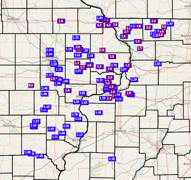
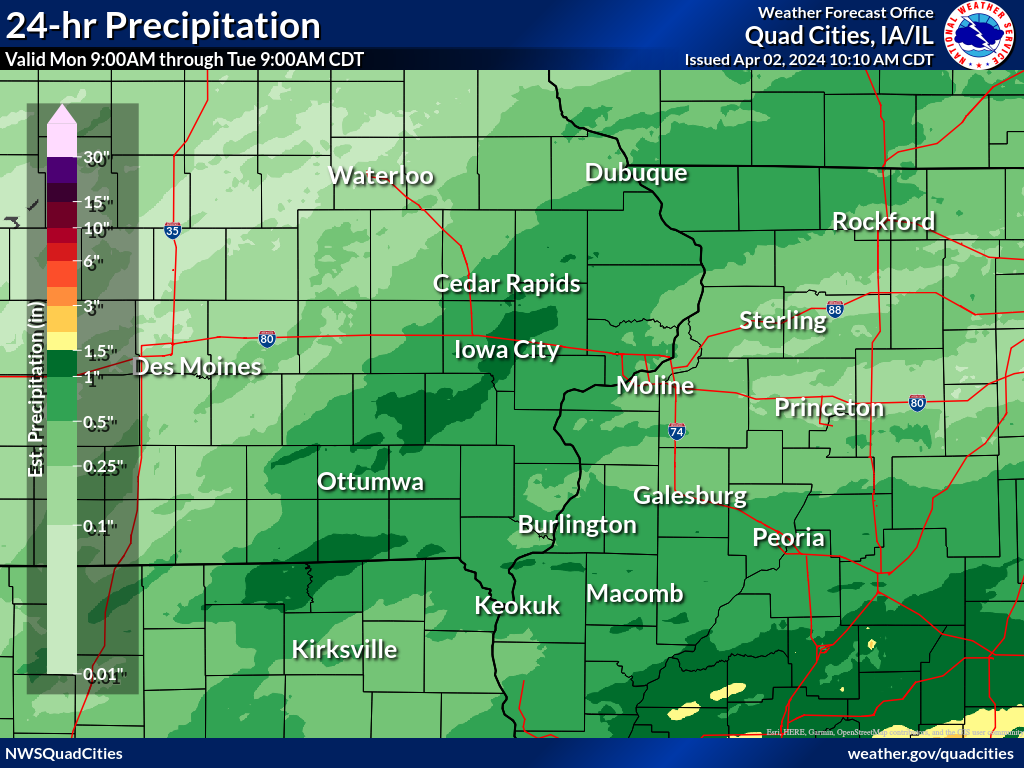
Rain Reports
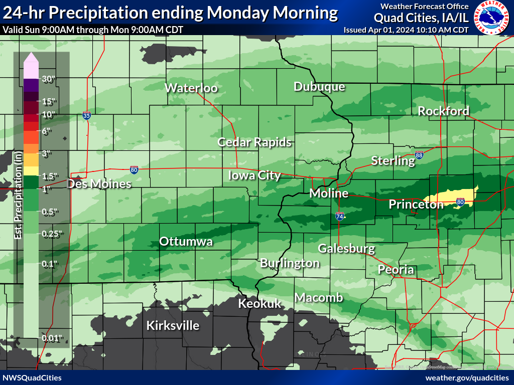
| 3-Day Overview Map | 24-hr Rainfall Ending 9am Monday |
24-hr Rainfall Ending 9am Tuesday |
|
 |
 |
 |
|
|
24-hr Rainfall Ending 9am Wednesday |
|||
.png) |
|||
...Highest 3-Day Rainfall Reports...

Observations are collected from a variety of sources with varying
equipment and exposures. We thank all volunteer weather observers
for their dedication. Not all data listed are considered official.

Location                     Amount    Time/Date       Provider
De Witt 5.4 ENE              4.37 in   0700 AM 04/03   COCORAHS
Mount Carroll 6.8 NNW        4.07 in   0730 AM 04/03   COCORAHS
Ainsworth 7.4 N              3.87 in   0700 AM 04/03   COCORAHS
2 N Muscatine                3.79 in   0700 AM 04/03   COOP
4 W Center Junction          3.71 in   0700 AM 04/03   COCORAHS
Illinois City 6.7 SW         3.69 in   0800 AM 04/03   COCORAHS
De Witt                      3.67 in   0800 AM 04/03   COOP
Viola 0.4 E                  3.64 in   0700 AM 04/03   COCORAHS
Aledo                        3.54 in   0630 AM 04/03   COOP
Riverdale 0.5 N              3.54 in   0700 AM 04/03   COCORAHS
Elizabeth                    3.53 in   0630 AM 04/03   COOP
Davenport 4.3 NE             3.53 in   0700 AM 04/03   COCORAHS
Davenport 0.9 WNW            3.52 in   0700 AM 04/03   COCORAHS
Eldridge 0.7 SSW             3.51 in   0700 AM 04/03   COCORAHS
Bettendorf 1.6 W             3.47 in   0730 AM 04/03   COCORAHS
Wellman 4.0 E                3.47 in   0545 AM 04/03   COCORAHS
Fairfield 5.7 NNE            3.46 in   0700 AM 04/03   COCORAHS
Hanover 0.2 NW               3.46 in   0700 AM 04/03   COCORAHS
Bellevue 12.2 NW             3.42 in   0735 AM 04/03   COCORAHS
Nichols 2.5 NNW              3.41 in   0700 AM 04/03   COCORAHS
Freeport 4.3 W               3.32 in   0500 AM 04/03   COCORAHS
Tipton 0.3 ESE               3.29 in   0700 AM 04/03   COCORAHS
Davenport 2.1 N              3.25 in   0730 AM 04/03   COCORAHS
Iowa City 2.3 E              3.24 in   0700 AM 04/03   COCORAHS
, IL                         3.19 in   0700 AM 04/03   COCORAHS
New Windsor 2.0 N            3.18 in   0700 AM 04/03   COCORAHS
Moline 0.7 NNE               3.11 in   0800 AM 04/03   COCORAHS
Fairfield                    3.10 in   0800 AM 04/03   COOP
Iowa City                    3.10 in   0700 AM 04/03   COOP
Galena 0.8 WSW               3.10 in   0700 AM 04/03   COCORAHS
Anamosa 0.6 ESE              3.07 in   0902 AM 04/03   COCORAHS
Fairfield                    3.06 in   0800 AM 04/03   COCORAHS
Maysville 0.1 SW             3.06 in   0800 AM 04/03   COCORAHS
Lowden                       3.04 in   0700 AM 04/03   COOP
Winslow 4.3 ESE              3.03 in   0700 AM 04/03   COCORAHS
Sigourney                    3.03 in   0700 AM 04/03   COOP
Tipton 0.7 N                 3.02 in   0800 AM 04/03   COCORAHS
Iowa City 1.0 NE             2.97 in   0700 AM 04/03   COCORAHS
Morning Sun 1.7 E            2.94 in   0800 AM 04/03   COCORAHS
Lena 0.3 SSE                 2.92 in   0700 AM 04/03   COCORAHS
West Branch 2.3 SSW          2.91 in   0600 AM 04/03   COCORAHS
Wapello 5.4 SE               2.91 in   0700 AM 04/03   COCORAHS
, IL                         2.91 in   0730 AM 04/03   COCORAHS
Davis 0.5 N                  2.90 in   0830 AM 04/03   COCORAHS
Stockton 3.4 NNE             2.89 in   0755 AM 04/03   COCORAHS
Farmington 3.5 W             2.83 in   0600 AM 04/03   COCORAHS
Washington 2 SSW             2.83 in   0700 AM 04/03   COOP
Stockton 3 Nne               2.81 in   0735 AM 04/03   COOP
Farmington 2.4 W             2.80 in   0600 AM 04/03   COCORAHS
Clarence 3.9 S               2.78 in   0700 AM 04/03   COCORAHS
Farmington 0.3 NW            2.77 in   0600 AM 04/03   COCORAHS
Farmington 0.4 NNW           2.74 in   0600 AM 04/03   COCORAHS
Fairfield 0.4 SE             2.72 in   0732 AM 04/03   COCORAHS
Coralville 1.3 SE            2.71 in   0715 AM 04/03   COCORAHS
Taylor Ridge 1.1 N           2.71 in   0700 AM 04/03   COCORAHS
Coralville 1.4 S             2.70 in   0800 AM 04/03   COCORAHS
Center Junction 2.6 W        2.70 in   0800 AM 04/03   COCORAHS
Washington 5.8 SW            2.70 in   0700 AM 04/03   COCORAHS
Geneseo 2.0 NW               2.68 in   0500 AM 04/03   COCORAHS
Monticello                   2.62 in   0600 AM 04/03   COOP
Freeport 2.9 WSW             2.57 in   0900 AM 04/03   COCORAHS
Kewanee 1 E                  2.57 in   0700 AM 04/03   COOP
Solon 0.4 WNW                2.55 in   0430 AM 04/03   COCORAHS
Anamosa 3 SSW                2.51 in   0700 AM 04/03   COOP
Camanche 1.2 W               2.49 in   0700 AM 04/03   COCORAHS
Dubuque 1.4 WNW              2.47 in   0700 AM 04/03   COCORAHS
North Liberty 0.7 SSW        2.45 in   0800 AM 04/03   COCORAHS
Park View 0.2 WSW            2.44 in   0700 AM 04/03   COCORAHS
Solon 0.3 ESE                2.41 in   0700 AM 04/03   COCORAHS
Charlotte 1.9 WNW            2.39 in   0700 AM 04/03   COCORAHS
Solon 4.2 SSW                2.39 in   0900 AM 04/03   COCORAHS
Wapello 0.2 S                2.33 in   0700 AM 04/03   COCORAHS
Dubuque 1.0 SE               2.31 in   0730 AM 04/03   COCORAHS
Oxford Junction 2.9 ENE      2.30 in   0900 AM 04/03   COCORAHS
Galva 0.4 NW                 2.27 in   0700 AM 04/03   COCORAHS
Dallas City 3.0 SSE          2.26 in   0600 AM 04/03   COCORAHS
Clinton 1.7 NNW              2.25 in   0600 AM 04/03   COCORAHS
Coal Valley 2.6 E            2.23 in   0800 AM 04/03   COCORAHS
Calamus 2.0 NE               2.21 in   0700 AM 04/03   COCORAHS
Davenport 1.0 NE             2.21 in   0600 AM 04/03   COCORAHS
East Dubuque 1.7 SE          2.21 in   0700 AM 04/03   COCORAHS
Mount Union 3.6 S            2.14 in   0900 AM 04/03   COCORAHS
Cedar Rapids 5.8 N           2.14 in   0700 AM 04/03   COCORAHS
New London 1.5 SW            2.11 in   0700 AM 04/03   COCORAHS
Tiffin 1.2 NE                2.11 in   0700 AM 04/03   COCORAHS
Robins 0.8 SE                2.11 in   0700 AM 04/03   COCORAHS
La Harpe 0.7 E               2.11 in   0930 AM 04/03   COCORAHS
Green Rock                   2.10 in   0900 AM 04/03   COCORAHS
Stockton 5.9 WNW             2.09 in   0700 AM 04/03   COCORAHS
2 WSW Yarmouth               2.08 in   0700 AM 04/03   COCORAHS
La Moille 0.2 NNE            2.08 in   0800 AM 04/03   COCORAHS
Manchester                   2.08 in   0700 AM 04/03   COOP
Donnellson                   2.07 in   0700 AM 04/03   COOP
La Harpe                     2.04 in   0800 AM 04/03   COOP
 |
Media use of NWS Web News Stories is encouraged! NWS Quad Cities Past Events Page: weather.gov/dvn/events |
|