Overview
A slowly moving storm system brought several rounds of showers and thunderstorms to eastern Iowa, northwest Illinois and far northeast Missouri during the day on Wednesday April 7, 2021. The heavy rainfall occurred south of a Fairfield to Galesburg line with reports ranging from 1.13 inches in Burlington to 1.80 inches in Bushnell Illinois. A few of these thunderstorms became severe and produced damaging winds in McDonough, Henderson, and Hancock Counties during the late afternoon and early evening hours. Damage was also reported to some mobile homes and a garage on the southwest side of Cedar Rapids due to a weak tornado that caused one minor injury.
Page will be updated as more information becomes available
Tornadoes:
|
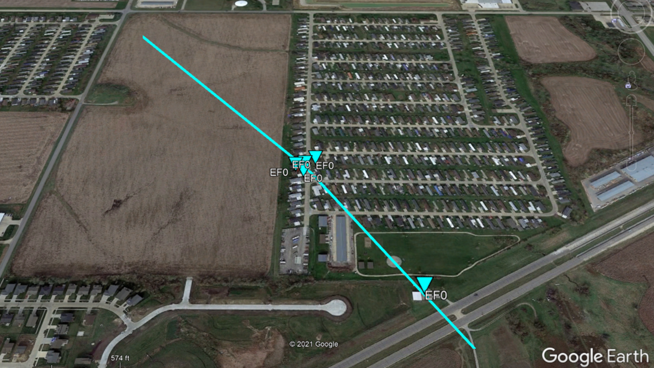
Tornado - SW Cedar Rapids
|
||||||||||||||||
The Enhanced Fujita (EF) Scale classifies tornadoes into the following categories:
| EF0 Weak 65-85 mph |
EF1 Moderate 86-110 mph |
EF2 Significant 111-135 mph |
EF3 Severe 136-165 mph |
EF4 Extreme 166-200 mph |
EF5 Catastrophic 200+ mph |
 |
|||||
Photos & Video
 |
 |
 |
|
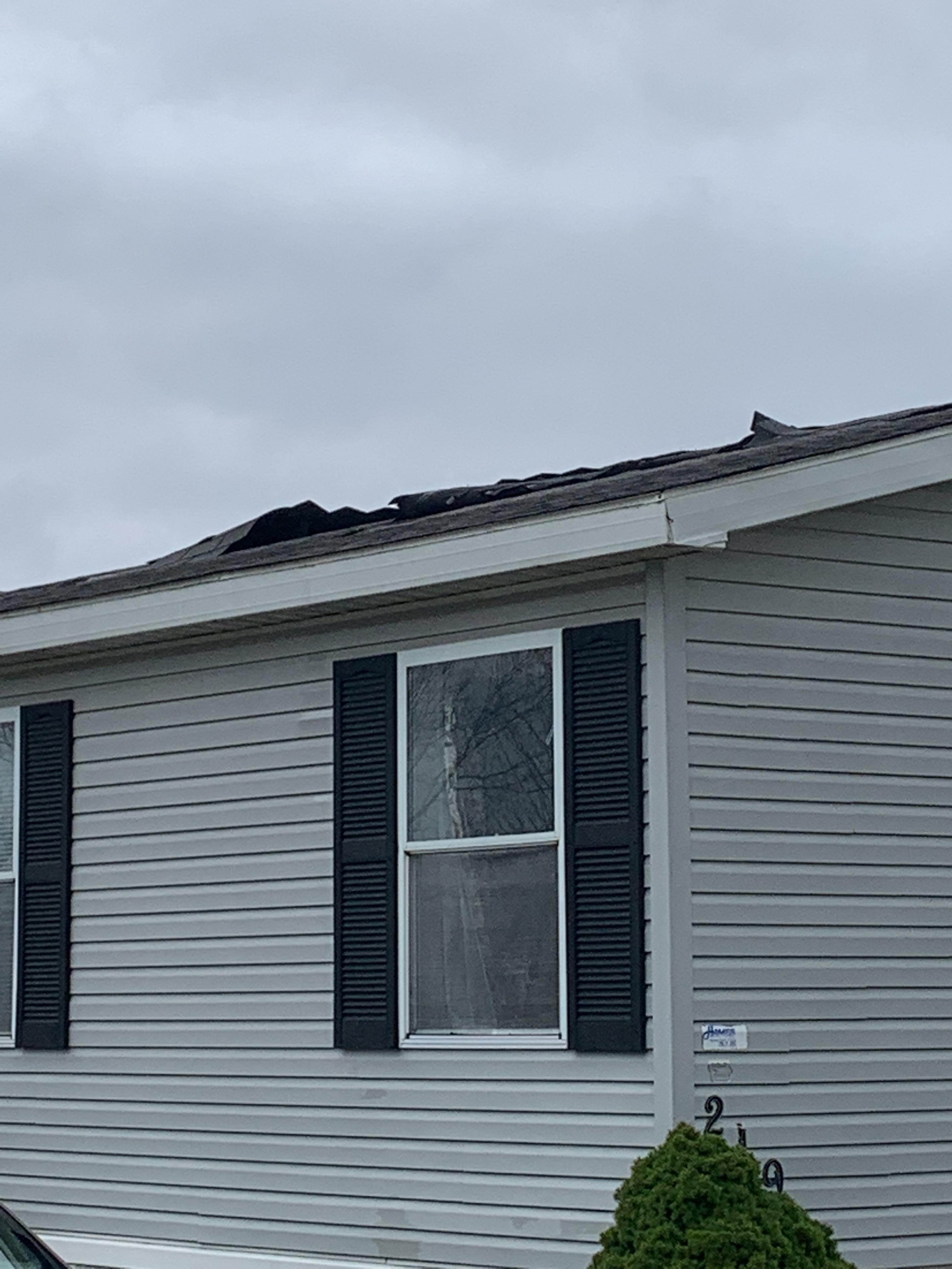
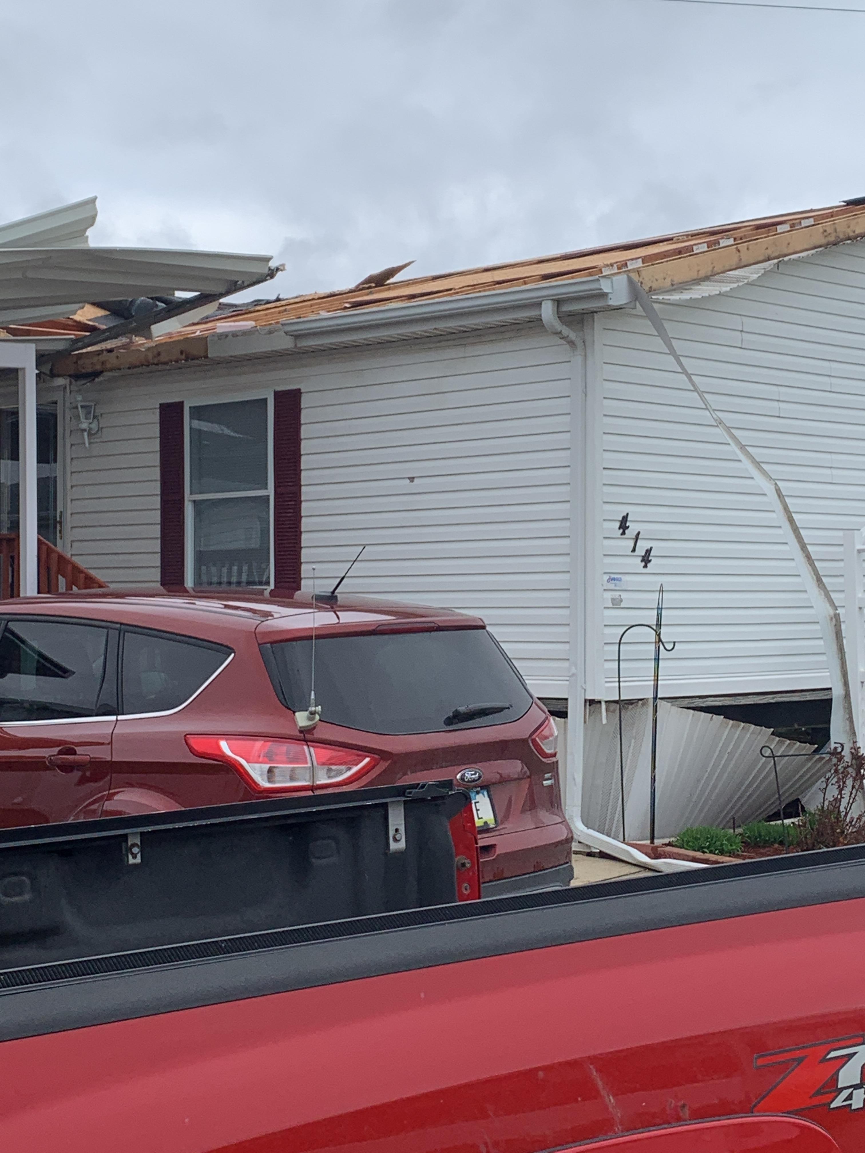
| Roof Damage, Manufactured Home (NWS Storm Survey) |
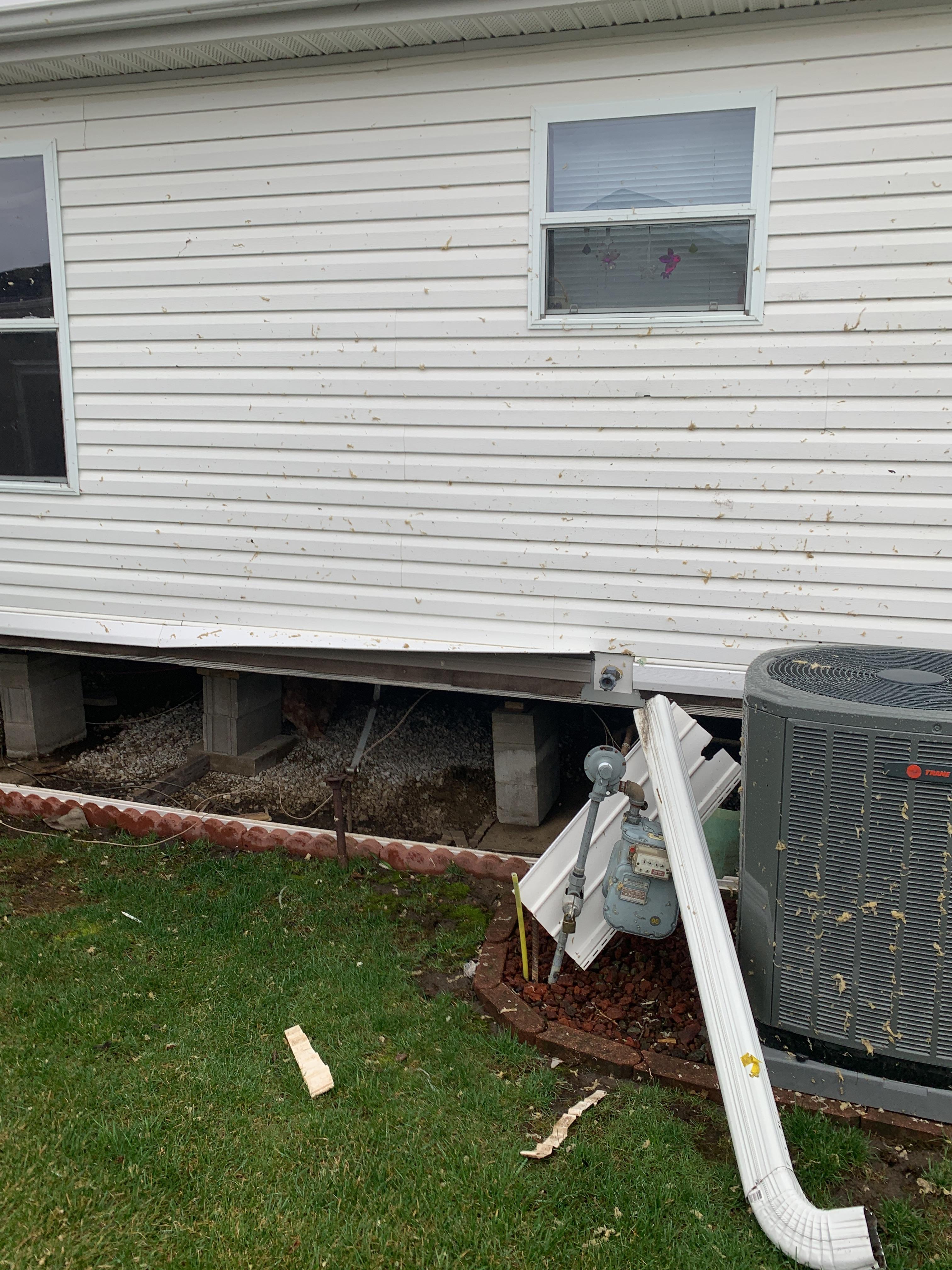
Siding and Manufactured Home Skirt Damage (NWS Storm Survey) |
Roof Damage to Manufactured Home (NWS Storm Survey) |
Radar
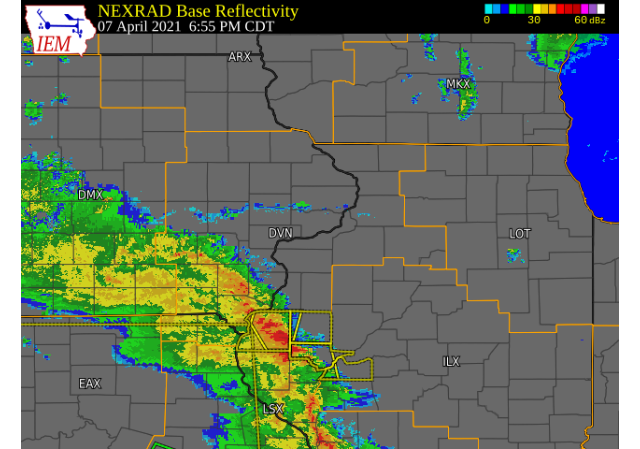 |
| April 7, 2021 Radar Loop |
Storm Reports
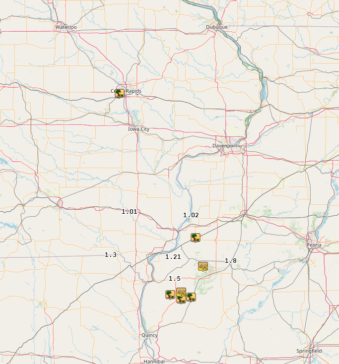 |
| Courtesy of IEM |
PRELIMINARY LOCAL STORM REPORT
NATIONAL WEATHER SERVICE QUAD CITIES IA IL
757 AM CDT THU APR 8 2021

..TIME...   ...EVENT...      ...CITY LOCATION...     ...LAT.LON...
..DATE...   ....MAG....      ..COUNTY LOCATION..ST.. ...SOURCE....
            ..REMARKS..
1047 AM     HEAVY RAIN       WEST POINT              40.71N 91.45W
04/08/2021  M1.80 INCH       LEE                IA   TRAINED SPOTTER
0750 PM     TSTM WND DMG     1 S ALEDO               41.18N 90.75W
04/07/2021                   MERCER             IL   TRAINED SPOTTER

            REPORT DELAYED. TRAINED SPOTTER REPORTED
            THUNDERSTORM WIND DAMAGE TO A FARM
            OUTBUILDING SOUTH OF ALEDO. PICTURES VIA
            SOCIAL MEDIA SHOW PART OF A WALL BLOWN OUT
            BUT THE BARN WAS OPEN TO ONE SIDE AND THE
            OTHER WALL IS PARTIALLY COVERED. TIME OF THE
            EVENT WAS ESTIMATED USING RADAR.
0823 AM     HEAVY RAIN       2 NNW OAKLAND MILLS     40.97N 91.63W
04/08/2021  M1.01 INCH       HENRY              IA   TRAINED SPOTTER
0756 AM     HEAVY RAIN       3 ENE CHARLIE HEATH MEM 40.61N 91.84W
04/08/2021  M1.30 INCH       CLARK              MO   TRAINED SPOTTER

            ANOTHER 0.6 FELL OVERNIGHT WITH A STORM
            TOTAL OF 1.30 INCHES.

0704 PM     TSTM WND GST     4 SE BLANDINSVILLE      40.51N 90.82W
04/07/2021  M55 MPH          MCDONOUGH          IL   TRAINED SPOTTER


0648 AM     HEAVY RAIN       BUSHNELL                40.56N 90.51W
04/08/2021  M1.80 INCH       MCDONOUGH          IL   TRAINED SPOTTER

            STORM TOTAL RAINFALL: 0.88 FELL PRIOR TO 5
            PM 4/7 WITH AN ADDITIONAL 0.92 AFTER 5 PM.

0730 PM     TSTM WND DMG     STRONGHURST             40.75N 90.90W
04/07/2021                   HENDERSON          IL   TRAINED SPOTTER

            TREE SNAPPED AND POWER LINE DOWN. REPORT VIA
            SOCIAL MEDIA.

0100 AM     HEAVY RAIN       OQUAWKA                 40.94N 90.95W
04/08/2021  M1.02 INCH       HENDERSON          IL   PUBLIC


0630 PM     TSTM WND DMG     1 N WEST POINT          40.27N 91.18W
04/07/2021                   HANCOCK            IL   EMERGENCY MNGR

            SPLIT POWER POLE.

0638 PM     TSTM WND DMG     BOWEN                   40.23N 91.06W
04/07/2021                   HANCOCK            IL   TRAINED SPOTTER

            SEVERAL ONE INCH DIAMETER TREE LIMBS DOWN.

0646 PM     TSTM WND GST     2 ENE DENVER            40.29N 91.06W
04/07/2021  E40 MPH          HANCOCK            IL   TRAINED SPOTTER

            ALONG WITH TORRENTIAL RAIN AND FREQUENT
            LIGHTNING.

0650 PM     TSTM WND DMG     1 N AUGUSTA             40.25N 90.95W
04/07/2021                   HANCOCK            IL   BROADCAST MEDIA

            4 INCH TREE BRANCHES BROKEN.

0600 AM     HEAVY RAIN       2 NNE COLUSA            40.59N 91.15W
04/08/2021  M1.21 INCH       HANCOCK            IL   PUBLIC


0613 AM     HEAVY RAIN       CARTHAGE                40.41N 91.13W
04/08/2021  M1.50 INCH       HANCOCK            IL   TRAINED SPOTTER
0836 PM     TORNADO          3 NE FAIRFAX            41.95N 91.74W
04/07/2021                   LINN               IA   NWS STORM SURVEY

            CORRECTS PREVIOUS TORNADO REPORT TO CHANGE
            THE TIME FROM AM TO PM 3 NE FAIRFAX. A BRIEF
            TORNADO CAUSED DAMAGE TO SEVERAL
            MANUFACTURED HOMES IN THE SOUTHWEST PART OF
            CEDAR RAPIDS WEDNESDAY EVENING. ONE HOME
            SUSTAINED SIGNIFICANT ROOF DAMAGE, WITH
            ADDITIONAL SIDING DAMAGE TO NEARBY HOMES.
            ONE PERSON SUSTAINED MINOR INJURIES FROM
            GLASS AFTER THEIR BEDROOM WINDOW BLEW IN.
            THE TORNADO LOFTED DEBRIS INTO A NEARBY
            FIELD. MAXIMUM SUSTAINED WINDS WERE AROUND
            85 MPH AND THE TORNADO WAS RATED EF-0.
Rain Reports
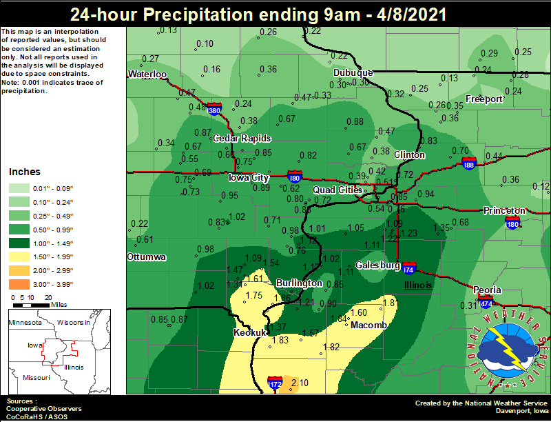 |
| COOP Observer Rainfall Reports ending 9 AM April 8, 2021 |
24 hour precipitation reports (in Inches),
for eastern Iowa, northwest and west central Illinois,
and northeast Missouri. Reported between 6 AM and 9 AM,
Thursday April 08, 2021.

....IOWA....
Beaconsfield 1 NNE               2.13
Fort Madison 0.9 NE              1.86
Donnellson                       1.75
West Point 7.5 NW                1.61
New London 1.5 SW                1.54
Salem 3.1 ESE                    1.47
Keokuk LD19                      1.37
Salem 1S                         1.31
Burlington 0.8 SSE               1.19
Burlington Arpt                  1.13
Burlington 2S                    1.12
Wapello 5.4 SE                   1.12
Burlington 6.5 SSW               1.11
Mt Pleasant 1 SSW                1.09
Keosauqua                        1.02
Washington                       1.02
Wapello 0.2 S                    0.98
Fairfield                        0.98
Wellman 4.0 E                    0.95
Rathbun Reservoir 2 N            0.92
Iowa City                        0.89
Maquoketa                        0.88
Fairfax 4.0 NW                   0.87
Centerville 0 NE                 0.87
Solon 0.3 ESE                    0.85
Ely 0.5 SE                       0.84
Washington 5.8 SW                0.83
Muscatine 1.4 N                  0.83
Tipton 0.7 N                     0.82
Muscatine 2N                     0.81
Muscatine 2.1 N                  0.80
Pella 4 N                        0.79
Morning Sun 1.7 E                0.76
North Liberty 0.7 SSW            0.75
Parnell 0.1 SSW                  0.75
North English                    0.73
Oskaloosa 1 NNW                  0.72
NWS Johnston* 5 NNW              0.72
Le Claire 1.8 NNE                0.72
Columbus Jct 2 SSW               0.71
Coralville 1.4 S                 0.69
Williamsburg                     0.69
Iowa City Arpt                   0.67
Calamus 2.0 NE                   0.67
Anamosa 3 SSW                    0.67
Marengo 3.6 N                    0.67
Cedar Rapids Arpt                0.66
West Liberty 0.7 NNW             0.62
West Branch 2.0 NNW              0.62
Ottumwa ASOS 6 NNW               0.61
Newton 1 NE                      0.57
Marengo 2.6 SSW                  0.55
Bettendorf 1.6 W                 0.51
Vinton                           0.48
Mount Auburn 2.2 NNW             0.47
Charlotte 1.9 WNW                0.47
Monticello 1 E                   0.47
Perry 0 W                        0.44
Eldridge 0.6 ESE                 0.42
Davenport Arpt                   0.39
Camanche 1.2 W                   0.39
Davenport 0.9 WNW                0.39
Boone 1 SSW                      0.39
Marion 1.7 NNW                   0.38
De Witt                          0.38
Mason City 1 NNE                 0.37
Asbury 0.4 SW                    0.36
Manchester                       0.36
Mason City ASOS 6 W              0.36
Ames US 30 2 SSE                 0.35
Belle Plaine                     0.34
Pella AWOS 2 WSW                 0.34
Cascade                          0.33
Bellevue LD12                    0.32
Marshalltown ASOS 4 N            0.31
Grinnell AWOS 2 SSW              0.31
Marshalltown 1 NW                0.30
Dubuque Arpt                     0.30
Peosta 2.9 E                     0.30
Dubuque #3 7 SW                  0.28
Waterloo ASOS 5 NW               0.27
Elkader 6SSW                     0.26
Central City 6.7 W               0.24
Guttenberg Dam 10                0.22
Rickardsville 0.2 W              0.22
Oskaloosa AWOS 9 ESE             0.22
Hampton 1 N                      0.20
Dubuque LD11                     0.17
Independence 0.9 WNW             0.16
Fayette 1 NW                     0.15
Toledo 3 N                       0.14
Tripoli 0 N                      0.13
Oelwein AWOS                     0.10
....ILLINOIS....
Quincy ASOS                      2.10
Colchester 3.5 NE                1.84
Warsaw 5.8 SE                    1.83
Augusta                          1.82
Prairie City 2S                  1.81
Macomb 3.8 NW                    1.60
Bentley                          1.57
Galesburg                        1.40
Galva 2.7 NE                     1.35
Alpha 2.3 N                      1.34
Woodhull 0.3 ESE                 1.23
Alpha 0.7 N                      1.22
Dallas City 3.0 SSE              1.21
Gladstone LD18                   1.12
Monmouth 4NW                     1.11
Alexis 1 SW                      1.11
New Windsor 2.0 N                1.09
Aledo                            1.05
Oquawka 0.5 N                    1.02
New Boston LD17                  1.01
Geneseo 2.0 NW                   0.94
La Harpe                         0.90
Coal Valley 2.6 E                0.85
Stronghurst 0.4 SSW              0.85
Fulton LD13                      0.83
Coal Valley 1.9 SE               0.76
Ill. City LD16 3 WNW             0.72
Morrison 3.2 E                   0.70
Jacksonville 2E                  0.69
Kewanee 1 E                      0.68
Moline 0.7 NNE                   0.65
Ottawa 4 SW                      0.55
Quad City Arpt                   0.54
Steward                          0.53
Bloomington Airport              0.53
Princeton                        0.50
Princeton 1.1 SE                 0.50
Rockford ASOS                    0.44
Rock Falls                       0.44
Jacksonville AWOS                0.44
Mount Carroll                    0.36
Walnut 5.3 ENE                   0.36
Lanark 5.3 N                     0.35
Lincoln NWS                      0.35
Rochelle AWOS                    0.34
Peoria ASOS                      0.31
Freeport 1.7 NW                  0.30
Davis 0.5 N                      0.28
Tuscola                          0.28
Freeport 2.0 NW                  0.27
Mount Carroll 6.8 NNW            0.26
Elizabeth                        0.25
Ridott 0.1 NE                    0.24
Winslow 4.3 ESE                  0.24
Freeport 2.9 WSW                 0.24
Decatur Airport                  0.23
Freeport                         0.21
Stockton 3.4 NNE                 0.13
Windsor                          0.12
Mendota 2 SE                     0.12
Joliet                           0.04
Mundelein                        0.03
Ogden                            0.02
Romeoville                       0.01
St Anne                          0.00
Galesburg Arpt                   0.00
....MISSOURI....
Columbia                         1.05
Kirksville ASOS                  0.90
Memphis 0.1 S                    0.87
Memphis                          0.85
....WISCONSIN....
Monroe 1 W                       0.29
Brodhead 1 SW                    0.25
Madison-ASOS                     0.19
Prairie du Chien AWOS            0.17
Watertown-AWOS                   0.13
Allenton-WWTP .6 NW              0.13
Beloit-College                   0.02
La Crosse WFO                    0.01
Viroqua                          0.01
....MINNESOTA....
Theilman 1SSW                    0.00
 |
Media use of NWS Web News Stories is encouraged! Please acknowledge the NWS as the source of any news information accessed from this site. |
|