Widespread, life-threatening considerable flash flooding is expected in south-central Texas through at least Friday. Catastrophic river flooding and rapid rises on small streams, arroyos, and typically dry washes are expected in the Texas Hill Country. Wildfire smoke is impacting air quality across much of the Great Lakes region into the Northeast U.S. with Air Quality Alerts in effect. Read More >
Event Summary: April 22, 2019
|
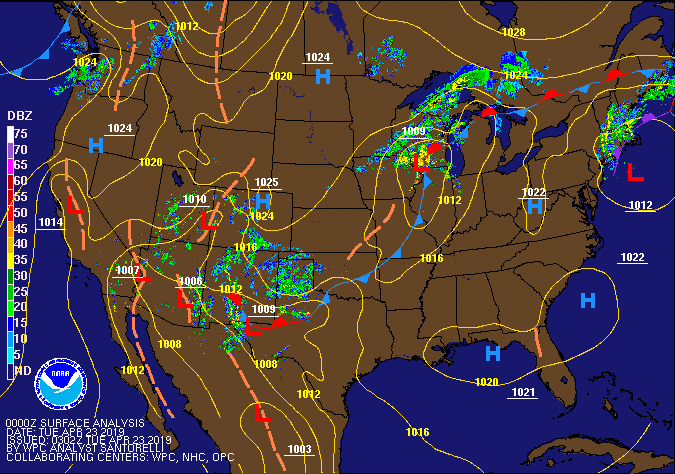
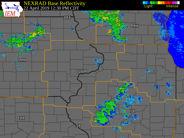
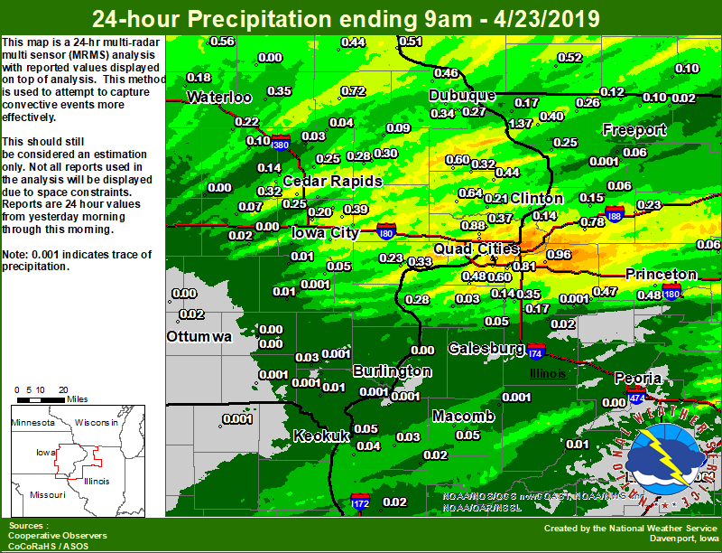
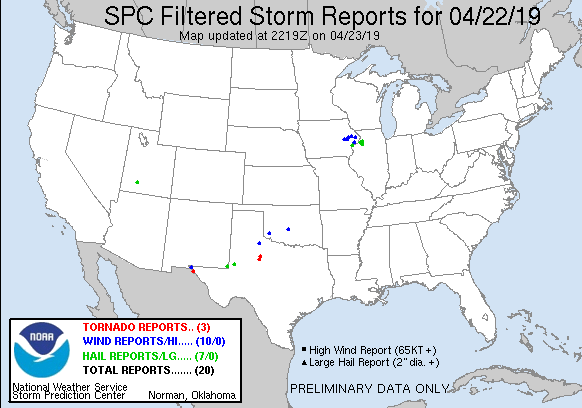
An area of low pressure and a cold front tracked across eastern Iowa and northwest Illinois during the afternoon and evening. This front served as the focus for the development of showers and thunderstorms, a few of which became severe. Thunderstorms produced large hail to the size of quarters and wind gusts over 60 MPH. The most notable wind report came from Walcott, IA, where a wind surge in the line of thunderstorms produced an estimated gust of 65 MPH. Hail to the size of quarters was observed in Muscatine, IA and Bettendorf, IA. Additionally, torrential rainfall from thunderstorms lead to rainfall amounts over one inch in the Quad Cities, which produced brief flash flooding along River Drive in Moline, IL.
|
|
Storm Reports
| SPC Storm Reports |
 |
PRELIMINARY LOCAL STORM REPORT...SUMMARY
NATIONAL WEATHER SERVICE QUAD CITIES IA IL
914 PM CDT MON APR 22 2019
..TIME... ...EVENT... ...CITY LOCATION... ...LAT.LON...
..DATE... ....MAG.... ..COUNTY LOCATION..ST.. ...SOURCE....
..REMARKS..
0800 PM FLASH FLOOD 3 NW MOLINE 41.51N 90.53W
04/22/2019 ROCK ISLAND IL BROADCAST MEDIA
CARS DRIVING INTO FLOOD WATER ALONG RIVER
DRIVE IN MOLINE.
0745 PM HEAVY RAIN RIVERDALE 41.55N 90.44W
04/22/2019 M1.60 INCH SCOTT IA COCORAHS
RAIN AND PEA SIZE HAIL FELL DURING STRONG
THUNDERSTORMS.
0733 PM HAIL 2 SSE DAVENPORT 41.54N 90.59W
04/22/2019 M0.25 INCH SCOTT IA TRAINED SPOTTER
0729 PM HAIL 2 SSE DAVENPORT 41.53N 90.59W
04/22/2019 E0.25 INCH SCOTT IA TRAINED SPOTTER
HAIL AND TORRENTIAL RAIN.
0728 PM HAIL 1 NNW BETTENDORF 41.58N 90.49W
04/22/2019 E0.75 INCH SCOTT IA TRAINED SPOTTER
0722 PM HAIL DAVENPORT 41.56N 90.60W
04/22/2019 E0.25 INCH SCOTT IA TRAINED SPOTTER
VISIBILITY DIMINISHED DUE TO TORRENTIAL
RAIN.
0700 PM TSTM WND GST 2 NNW WALCOTT 41.62N 90.78W
04/22/2019 E65 MPH SCOTT IA NWS EMPLOYEE
0658 PM HAIL 1 NE STOCKTON 41.60N 90.85W
04/22/2019 E0.25 INCH SCOTT IA TRAINED SPOTTER
0652 PM HAIL SUNBURY 41.67N 90.93W
04/22/2019 E0.25 INCH CEDAR IA TRAINED SPOTTER
TORRENTIAL RAIN AND STRONG WIND.
0645 PM HAIL WILTON 41.59N 91.03W
04/22/2019 E0.25 INCH MUSCATINE IA TRAINED SPOTTER
0640 PM HAIL 2 SSW LIME CITY 41.63N 91.10W
04/22/2019 E0.25 INCH CEDAR IA TRAINED SPOTTER
PEA SIZE HAIL AND TORRENTIAL RAIN. DITCHES
ARE NEARLY FULL.
0605 PM TSTM WND GST DELMAR 42.00N 90.61W
04/22/2019 M60 MPH CLINTON IA TRAINED SPOTTER
0530 PM HAIL 3 E ROCK GROVE 42.46N 89.46W
04/22/2019 E0.25 INCH STEPHENSON IL PUBLIC
HALF INCH HAIL 530-540 PM CDT.
0527 PM HAIL 1 NNE OAKDALE 41.71N 91.59W
04/22/2019 E0.25 INCH JOHNSON IA TRAINED SPOTTER
0451 PM TSTM WND DMG 1 E ONSLOW 42.11N 90.99W
04/22/2019 JONES IA EMERGENCY MNGR
SIGNS AND TREE LIMBS DOWN ON E29 EAST OF
ONSLOW.
0430 PM HAIL MARTELLE 42.02N 91.36W
04/22/2019 E0.25 INCH JONES IA PUBLIC
0427 PM TSTM WND GST MARTELLE 42.02N 91.36W
04/22/2019 E60 MPH JONES IA EMERGENCY MNGR
WIND MOVED A FIRE TRUCK (WIND ESTIMATED
HIGHER).
0415 PM TSTM WND DMG MOUNT VERNON 41.92N 91.43W
04/22/2019 LINN IA PUBLIC
TREE DOWN IN MT VERNON FROM THUNDERSTORM
WINDS. PICTURE WAS FROM SOCIAL MEDIA. TIME
ESTIMATED FROM RADAR.
0404 PM HAIL 3 ESE CEDAR RAPIDS 41.96N 91.61W
04/22/2019 M0.25 INCH LINN IA TRAINED SPOTTER
0402 PM HAIL 3 E CEDAR RAPIDS 41.97N 91.61W
04/22/2019 E0.25 INCH LINN IA TRAINED SPOTTER
0342 PM HAIL 1 NNE BROOK HAVEN 41.68N 89.91W
04/22/2019 E1.00 INCH WHITESIDE IL EMERGENCY MNGR
QUARTER SIZE HAIL OR POSSIBLY SLIGHTLY
LARGER AT STAR AND YAGER RDS. QUARTER SIZED
HAIL CONTINUED SOUTH OF INTERSECTION FOR
UNKNOWN DISTANCE. TIME ESTIMATED FROM RADAR.
0336 PM HAIL PROPHETSTOWN 41.67N 89.93W
04/22/2019 E0.25 INCH WHITESIDE IL PUBLIC
0336 PM HAIL PROPHETSTOWN 41.67N 89.93W
04/22/2019 E0.75 INCH WHITESIDE IL EMERGENCY MNGR
TIME ESTIMATED FROM RADAR. EM REPORTS
CONSIDERABLE AMOUNT OF HAIL IN PROPHETSTOWN
THAT MAY HAVE BEEN PENNY SIZE.
0325 PM HAIL 3 SW SPRING HILL 41.58N 90.10W
04/22/2019 M1.00 INCH HENRY IL TRAINED SPOTTER
0315 PM HAIL KEYSTONE 42.00N 92.20W
04/22/2019 E0.88 INCH BENTON IA PUBLIC
AND HARD RAIN.
0305 PM HAIL 2 SW BETTENDORF 41.55N 90.51W
04/22/2019 M0.88 INCH SCOTT IA PUBLIC
A NUMBER OF HAILSTONES MEASURED 7/8 IN
DIAMETER AFTER SOME MELTING (~5 MINUTES
AFTER HAIL HAD FALLEN).
0305 PM HAIL BETTENDORF 41.55N 90.44W
04/22/2019 E0.70 INCH SCOTT IA PUBLIC
HAIL JUST ABOUT COVERED THE GROUND AND FELL
IN AN AREA AROUND LINCOLN ROAD AND 18TH
STREET.
0302 PM HAIL BETTENDORF 41.56N 90.48W
04/22/2019 M0.88 INCH SCOTT IA TRAINED SPOTTER
HAIL ENDED ABOUT 3 MINUTES AGO.
0300 PM HAIL 2 NE BETTENDORF 41.58N 90.46W
04/22/2019 M0.88 INCH SCOTT IA TRAINED SPOTTER
0257 PM HAIL 1 NNE BETTENDORF 41.58N 90.47W
04/22/2019 M0.88 INCH SCOTT IA TRAINED SPOTTER
0252 PM HAIL 3 E CREDIT ISLAND 41.52N 90.57W
04/22/2019 E0.25 INCH ROCK ISLAND IL TRAINED SPOTTER
0250 PM HAIL 2 NNE ROCK ISLAND 41.50N 90.57W
04/22/2019 E0.25 INCH ROCK ISLAND IL TRAINED SPOTTER
BRIEF HAIL - 1 SE OF DOWNTOWN.
0213 PM HAIL 3 NE MUSCATINE 41.45N 91.03W
04/22/2019 E0.25 INCH MUSCATINE IA PUBLIC
DIME SIZED HAIL AT 2:14 IN MUSCATINE IOWA.
CORNER OF 2ND AVE AND HIGHWAY 61.
0210 PM HAIL 3 ENE MUSCATINE 41.44N 91.03W
04/22/2019 E0.75 INCH MUSCATINE IA TRAINED SPOTTER
HAIL AND VERY HEAVY RAIN.
0208 PM HAIL 3 ENE MUSCATINE 41.44N 91.03W
04/22/2019 E1.00 INCH MUSCATINE IA TRAINED SPOTTER
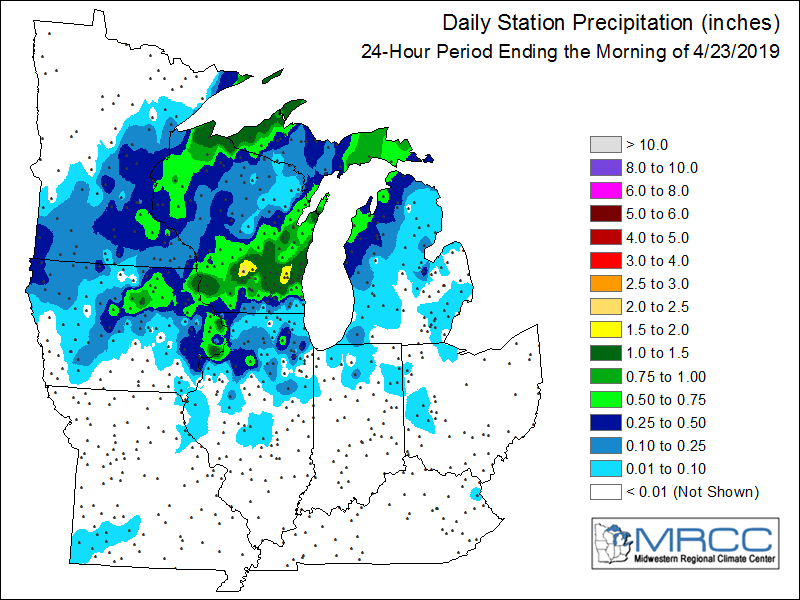
Area Rainfall Amounts
|
24-hr Local Rainfall Map
|
24-hr Regional Rainfall Map
|
24 hour precipitation reports (in Inches),
for eastern Iowa, northwest and west central Illinois,
and northeast Missouri. Reported between Midnight and 9 AM,
Tuesday April 23, 2019.

....IOWA....
Bettendorf 2.2 SE                1.60
Riverdale 0.5 N                  1.42
Bettendorf 1.6 WSW               1.41
Bellevue LD12                    1.37
Davenport 0.9 SSW                1.25
Davenport 0.9 WNW                1.10
Davenport 2.9 W                  1.10
Davenport Arpt 5 N               1.06
Eldridge 0.7 SSW                 0.88
Hampton 1 N                      0.80
Manchester                       0.72
Calamus 2.0 NE                   0.64
Maquoketa 4 W                    0.60
Tripoli 0 N                      0.56
Dubuque #3 7 SW                  0.53
Guttenberg Dam 10                0.51
Muscatine 2N                     0.51
Rickardsville 0.2 W              0.46
Elkader 6SSW                     0.44
Charlotte 1.9 WNW                0.44
Iowa City 8.0 NE                 0.39
Dubuque LD11                     0.38
Park View 0.2 WSW                0.37
Independence 0.9 WNW             0.35
Dubuque 1.4 WSW                  0.35
Cresco 1 NE                      0.34
Boone 1 SSW                      0.34
Peosta 2.9 E                     0.34
Iowa City                        0.33
Fairfax 4.0 NW                   0.32
Delmar 2.3 NW                    0.32
Coralville 1.4 S                 0.32
Anamosa 1.9 SE                   0.30
Anamosa 3 SSW                    0.28
Dubuque Arpt 7 SW                0.27
Marion 1.7 NNW                   0.25
Cedar Rapids Arpt 5 SW           0.25
Muscatine 2.1 N                  0.23
Mount Auburn 2.2 NNW             0.22
Marshalltown 1 NW                0.21
De Witt                          0.21
Perry 0 W                        0.20
North Liberty 0.7 SSW            0.20
Solon 0.3 ESE                    0.19
Waterloo ASOS 5 NW               0.18
West Branch 2.0 NNW              0.18
Camanche 1.2 W                   0.14
Palo 4.4 SSW                     0.14
Marshalltown ASOS 4 N            0.12
Ely 0.5 SE                       0.11
Iowa City Arpt                   0.10
Ames US 30 2 SSE                 0.10
Vinton                           0.10
Monticello 1 E                   0.09
Marengo 2.6 SSW                  0.07
Mason City ASOS 6 W              0.06
Keokuk LD19                      0.05
Ainsworth 7.4 N                  0.05
Coggon                           0.04
Salem 1S                         0.03
NWS Johnston* 5 NNW              0.03
Central City 6.7 W               0.03
Kalona 7.3 NNW                   0.02
Ottumwa ASOS 6 NNW               0.02
Parnell 0.1 SSW                  0.02
Burlington Arpt 2 SW             0.01
Wellman 4.0 E                    0.01
Donnellson                       0.01
Washington 5.8 SW                0.01
Toledo 3 N                       0.00
Keosauqua                        0.00
West Point 7.5 NW                0.00
Salem 3.1 ESE                    0.00
Washington                       0.00
Burlington 6.5 SSW               0.00
Rathbun Reservoir 2 N            0.00
Mason City 1 NNE                 0.00
Centerville 0 NE                 0.00
Brighton                         0.00
Oskaloosa 1 NNW                  0.00
Fairfield                        0.00
Beaconsfield 1 NNE               0.00
Fairfield 0.6 E                  0.00
Grinnell AWOS 2 SSW              0.00
Belle Plaine                     0.00
Oskaloosa AWOS 9 ESE             0.00
Oelwein AWOS                     0.00
Pella AWOS 2 WSW                 0.00
Williamsburg                     0.00
....ILLINOIS....
Quad City Arpt 3 S               1.09
Moline 0.7 NNE                   1.00
Geneseo 2.0 NW                   0.96
Coal Valley 2.6 E                0.81
Prophetstown 0.2 SW              0.78
Moline 1.0 WNW                   0.72
Coal Valley 1.9 SE               0.60
Princeton 1.1 SE                 0.56
Princeton                        0.56
Milan 8.8 SSW                    0.48
Tiskilwa 2.1 N                   0.48
Kewanee 1 E                      0.47
Elizabeth                        0.40
Alpha 2.3 N                      0.35
Ill. City LD16 3 WNW             0.33
New Boston LD17                  0.28
Stockton 3.4 NNE                 0.26
Savanna 4.6 N                    0.25
Rock Falls                       0.23
Steward                          0.21
Rochelle                         0.19
Galena                           0.17
Woodhull 0.3 ESE                 0.17
Morrison 3.2 E                   0.15
New Windsor 2.0 N                0.14
Streator 3 SE                    0.13
Orangeville 2.8 NW               0.12
Winslow 4.3 ESE                  0.12
Ottawa 4 SW                      0.10
Dakota 4.8 NW                    0.10
Romeoville                       0.08
Coleta 1.4 SSW                   0.06
Lanark 6.0 E                     0.06
Mendota 2 SE                     0.06
Freeport                         0.05
Colchester 3.5 NE                0.05
Minonk                           0.05
Alexis 1 SW                      0.05
Rockford ASOS                    0.04
Warsaw 5.8 SE                    0.04
Aledo                            0.03
Bentley                          0.03
Freeport 2.0 NW                  0.02
Rochelle AWOS                    0.02
Davis 0.5 N                      0.02
Augusta                          0.02
Quincy ASOS                      0.02
Freeport 2.9 WSW                 0.02
Roscoe 2SE                       0.02
Altona                           0.02
Mundelein                        0.01
Havana                           0.01
Freeport 1.7 NW                  0.01
Pearl City 0.4 SW                0.01
Dallas City 3.0 SSE              0.00
Galva 2.7 NE                     0.00
Shannon 0.2 S                    0.00
St Anne                          0.00
Prairie City 2S                  0.00
Lincoln NWS                      0.00
Windsor                          0.00
Decatur Airport                  0.00
Galesburg                        0.00
Gladstone LD18                   0.00
Ogden                            0.00
Peoria ASOS                      0.00
Joliet                           0.00
Bloomington Airport              0.00
Tuscola                          0.00
Galesburg Arpt 3 SW              0.00
Jacksonville AWOS                0.00
....MISSOURI....
Memphis                          0.00
Columbia                         0.00
Kirksville ASOS                  0.00
Chillicothe 2 NW                 0.00
....WISCONSIN....
Allenton-WWTP .6 NW              1.92
Steuben 4SE 3 NE                 1.45
Madison-ASOS                     1.16
Watertown-AWOS                   0.68
Viroqua                          0.56
Darlington                       0.52
Prairie du Chien AWOS            0.45
Whitewater                       0.42
La Crosse WFO                    0.36
Brodhead 1 SW                    0.10
Beloit-College                   0.02
....MINNESOTA....
Theilman 1SSW                    0.54
Grand Meadow                     0.10
Environmental Analysis / Other Information
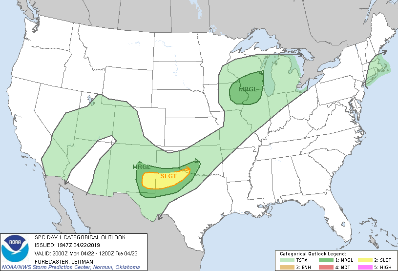
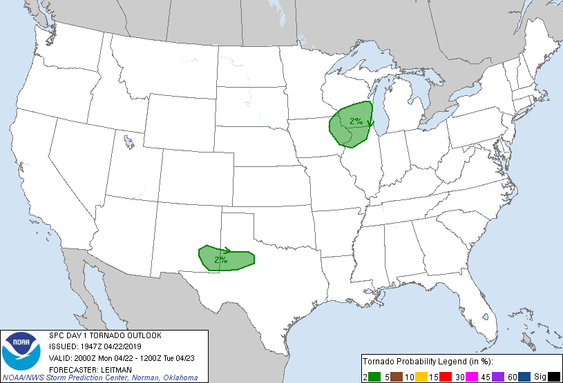
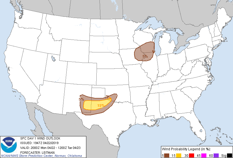
SPC Convective Outlooks
 |
 |
 |
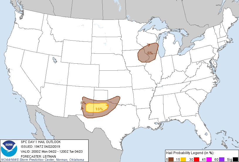 |
| SPC Day 1 Outlook (2000z) | SPC Day 1 Tornado Outlook (2000z) | SPC Day 1 Wind Outlook (2000z) | SPC Day 1 Hail Outlook (2000z) |
Sounding Analysis
 |
 |
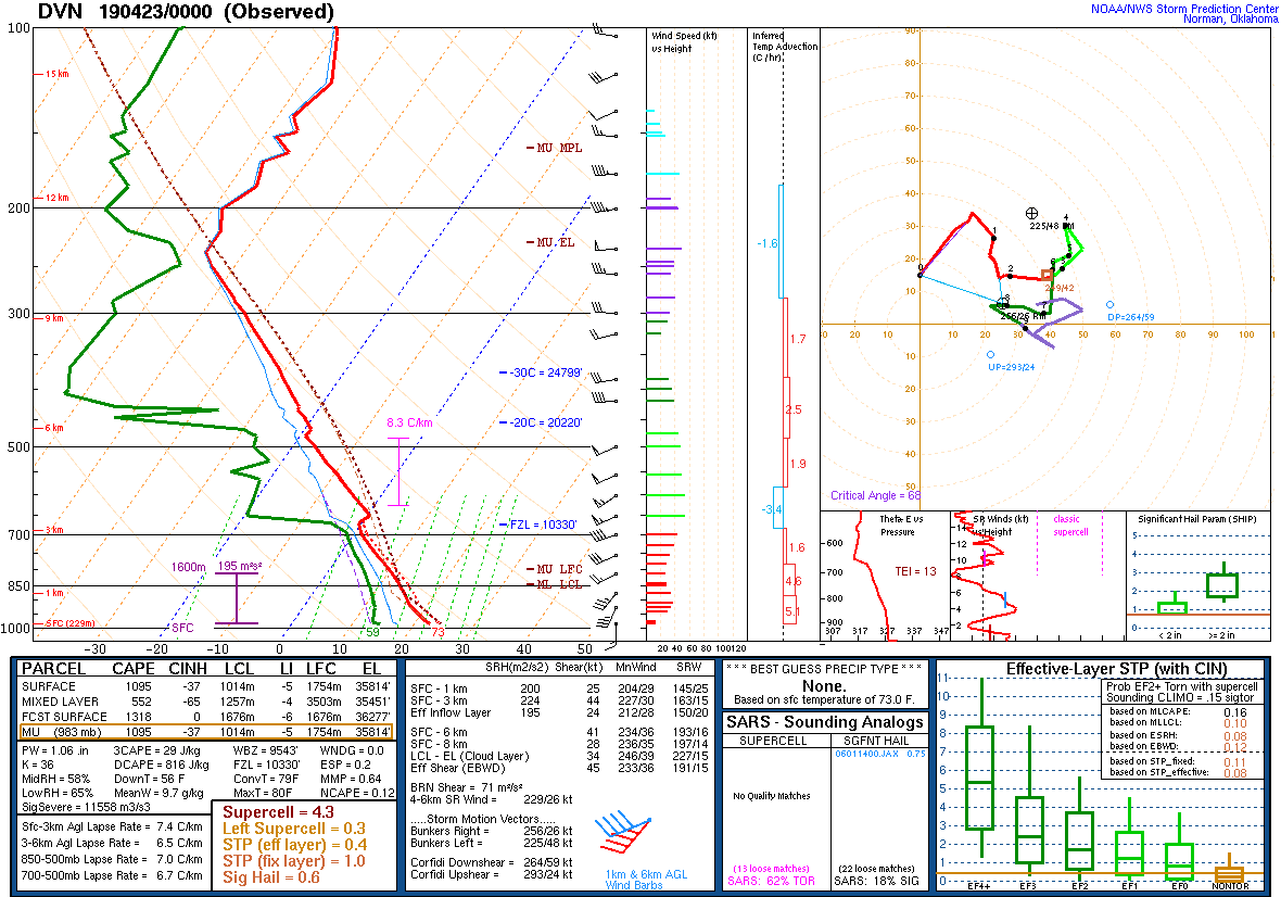 |
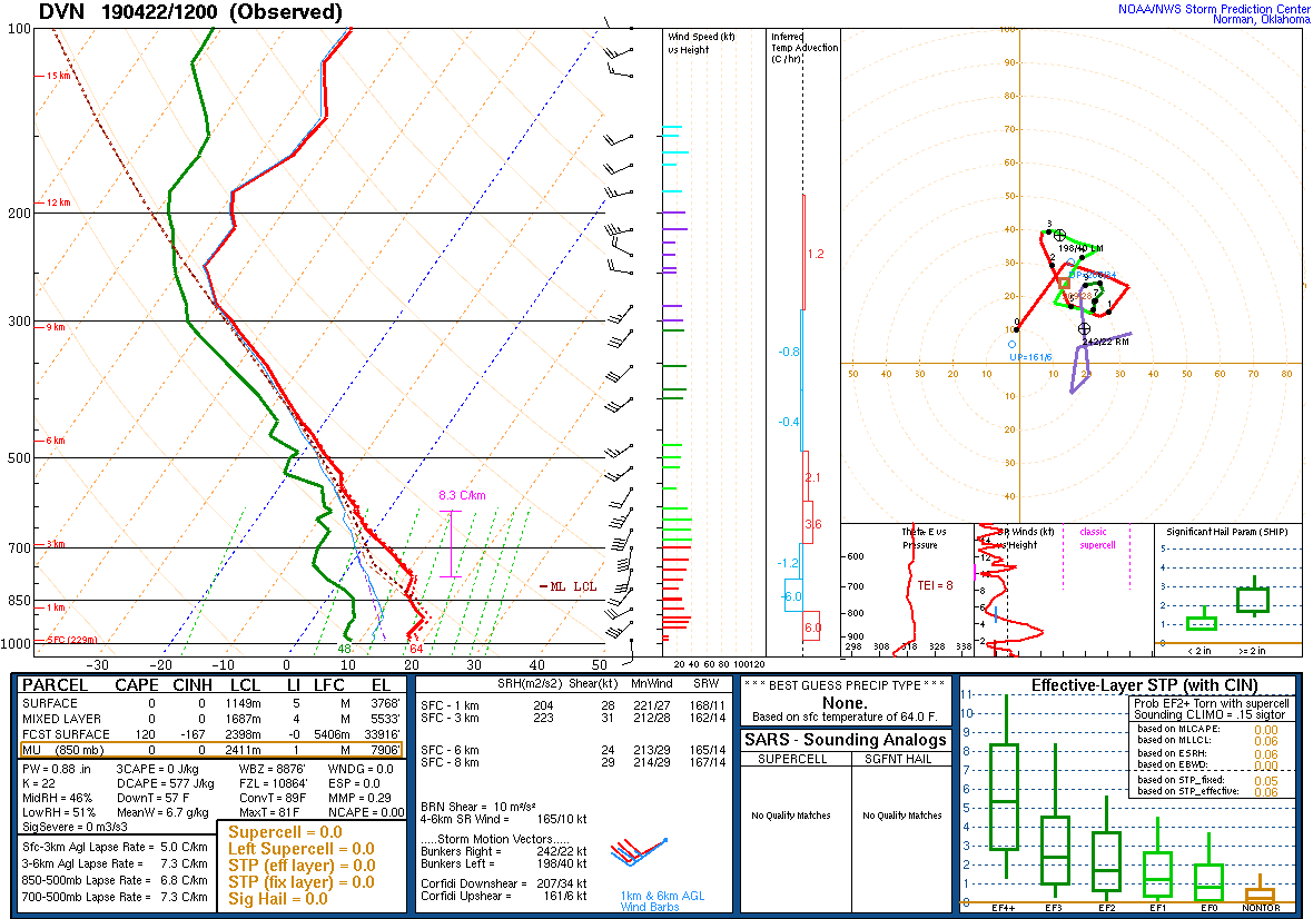
| DVN Sounding 4/22/19 12z | DVN Sounding 4/22/19 18z | ILX Sounding 4/23/19 00z |
SPC Mesoscale Discussions Issued for Our Area
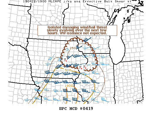 |
| SPC Mesoscale Discussion #419 (see link for more details) |
SPC - Storm Prediction Center
 |
Media use of NWS Web News Stories is encouraged! Please acknowledge the NWS as the source of any news information accessed from this site. |
|