Overview
|
A line of very gradually fading storms produced surges of straight-line wind damage. These were most pronounced to the immediate south of mesovortices (small scale circulations within the thunderstorm line that can in themselves result in tornadoes). Based on the nature of damage, observations, and radar, these reflect 65-80 mph wind gusts. |
 |
Storm Reports
 |
 |
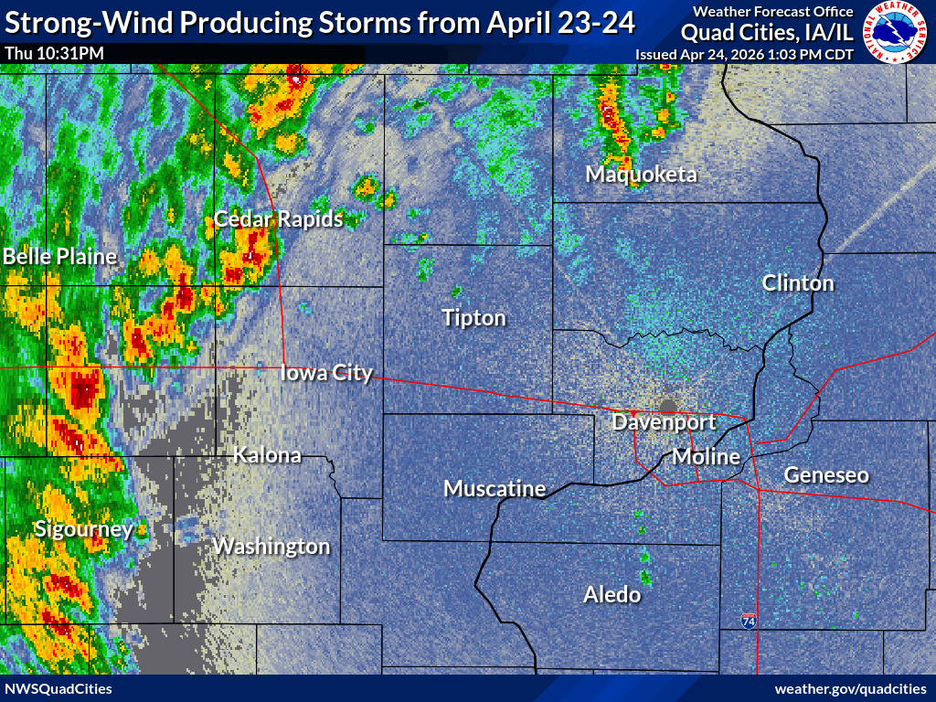
| Nationwide Storm Reports (SPC) |
Local Reports of Straight-Line Wind Gusts of 50+ mph or Wind Damage |
Preliminary Local Storm Report...Summary
National Weather Service Quad Cities IA IL

..TIME...   ...EVENT...      ...CITY LOCATION...     ...LAT.LON...
..DATE...   ....MAG....      ..COUNTY LOCATION..ST.. ...SOURCE....
            ..REMARKS..

0923 PM     Tstm Wnd Gst     Iowa City Airport       41.63N 91.55W
04/23/2026  M53 MPH          Johnson            IA   ASOS

            ASOS station KIOW Iowa City Arpt.

1054 PM     Tstm Wnd Dmg     2 W Kalona              41.49N 91.73W
04/23/2026                   Washington         IA   Emergency Mngr

            One building destroyed, another damaged, and
            main building with roof damage at lumber
            yard. Likely 80+ mph winds given damage.
            Time estimated using radar.

1055 PM     Tstm Wnd Dmg     1 W Kalona              41.49N 91.71W
04/23/2026                   Washington         IA   Emergency Mngr

            Multiple trees down. Including at least one
            on a home. Time estimated using radar.
1055 PM     Tstm Wnd Dmg     2 N Pleasant Plain      41.18N 91.86W
04/23/2026                   Washington         IA   Trained Spotter

            Machine shed heavily damaged. The door was
            blown off and took down a power pole and
            lines. Time estimated based off radar.

1108 PM     Tstm Wnd Dmg     3 ESE Iowa City         41.65N 91.48W
04/23/2026                   Johnson            IA   Emergency Mngr

            Power lines downed in the area due to strong
            thunderstorm winds.

1108 PM     Tstm Wnd Dmg     1 ESE Iowa City Municip 41.63N 91.54W
04/23/2026                   Johnson            IA   Emergency Mngr

            Light structural damage to homes in the
            community, resulting from strong
            straight-line thunderstorm winds.

1110 PM     Tstm Wnd Gst     2 SE Iowa City          41.64N 91.51W
04/23/2026  M69 MPH          Johnson            IA   Trained Spotter

            Corrects previous tstm wnd gst report from 2
            SE Iowa City of a 60 MPH. measured a 60
            knots gust on home weather station.

1110 PM     Tstm Wnd Dmg     2 SE Iowa City          41.64N 91.51W
04/23/2026                   Johnson            IA   Public

            Shingles blown off a roof. Multiple large
            trees downed.

1110 PM     Tstm Wnd Gst     2 SE Iowa City          41.64N 91.51W
04/23/2026  M57 MPH          Johnson            IA   Mesonet


1133 PM     Tstm Wnd Gst     Tipton                  41.77N 91.13W
04/23/2026  M60 MPH          Cedar              IA   Public

            Time estimated using radar.
1136 PM     Tstm Wnd Dmg     3 E Waubeek             42.16N 91.41W
04/23/2026                   Linn               IA   Emergency Mngr

            Outbuilding roof and walls damaged along
            with a grain bin. Time estimated using
            radar.

1138 PM     Tstm Wnd Dmg     1 N Muscatine           41.44N 91.07W
04/23/2026                   Muscatine          IA   Public

            Tree downed off Cedar Street. Time estimated
            using radar.

1215 AM     Tstm Wnd Gst     Davenport Ariport       41.61N 90.59W
04/24/2026  M70 MPH          Scott              IA   ASOS

            ASOS measured a 60 knot gust from decaying
            thunderstorms outflow.

1216 AM     Tstm Wnd Dmg     1 SSW Mount Joy         41.60N 90.56W
04/24/2026                   Scott              IA   Public

            John Deere employee reported damage to a
            100-foot section of their roof.

1227 AM     Tstm Wnd Dmg     Miles                   42.05N 90.32W
04/24/2026                   Jackson            IA   Fire Dept/Rescue

            40 by 90 ft shed was destroyed. Some tree
            damage in town. Time estimated using radar.

1228 AM     Tstm Wnd Dmg     3 NE Bettendorf         41.56N 90.45W
04/24/2026                   Scott              IA   Public

            Tree downed. Time estimated using radar.

1232 AM     Tstm Wnd Gst     Clinton Airport         41.82N 90.32W
04/24/2026  M52 MPH          Clinton            IA   AWOS

            AWOS station KCWI Clinton Arpt.

1237 AM     Tstm Wnd Gst     3 N Stockton            42.40N 89.99W
04/24/2026  M60 MPH          Jo Daviess         IL   Trained Spotter

            gust from Thunderstorm Measured with Robert
            Young Anemometer.

1241 AM     Tstm Wnd Dmg     Savanna                 42.09N 90.14W
04/24/2026                   Carroll            IL   Public

            Multiple trees downed in town. Relayed
            through media. Time estimated using radar.

0130 AM     Rain             3 SW Cedar Rapids       41.94N 91.72W
04/24/2026  M2.10 Inch       Linn               IA   Public


0130 AM     Rain             1 W Dubuque             42.51N 90.72W
04/24/2026  M1.22 Inch       Dubuque            IA   Public


0130 AM     Rain             2 SE Manchester         42.46N 91.43W
04/24/2026  M1.84 Inch       Delaware           IA   Trained Spotter


0130 AM     Rain             Manchester              42.48N 91.46W
04/24/2026  M2.41 Inch       Delaware           IA   Mesonet


0350 AM     Rain             3 NNE Cedar Rapids      42.01N 91.66W
04/24/2026  M1.73 Inch       Linn               IA   Trained Spotter
Photos
 |
| Kalona, IA (Amanda West) |
Radar
|
|
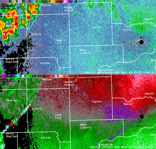 |
| Radar Loop: 10:30 PM April 23 - 1:00 AM April 24 | Zoomed-in KDVN 0.5° reflectivity (top) and velocity (bottom) from 10:30 PM, April 23 - 12:30 AM, April 24. Bright colors on the velocity indicate high wind speeds inbound toward the radar in Davenport, IA. |
 |
Media use of NWS Web News Stories is encouraged! |
|