Life-threatening and locally catastrophic flash and urban flooding is expected across portions of south-central Texas through early Friday, with significant river flooding and rapid rises on small streams, arroyos, and typically dry washes expected. A significant heat wave continues for the Rockies, Northern Plains, and Great Lakes into the Mid-Atlantic, peaking in intensity through midweek. Read More >
Overview
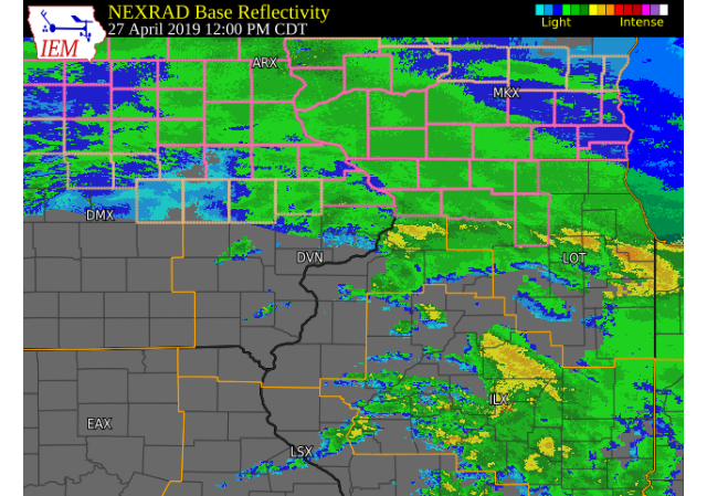
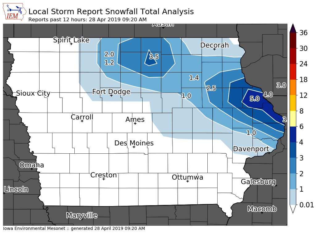
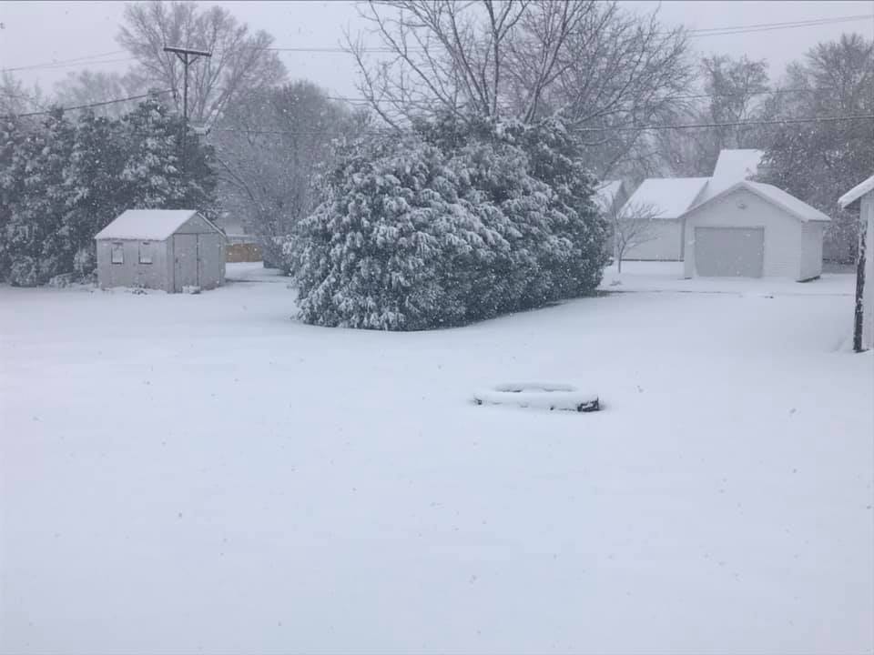
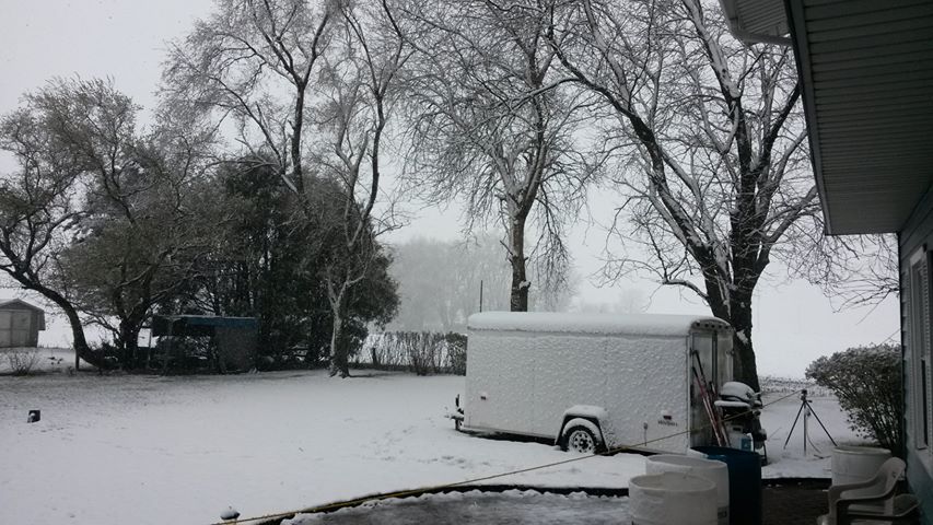
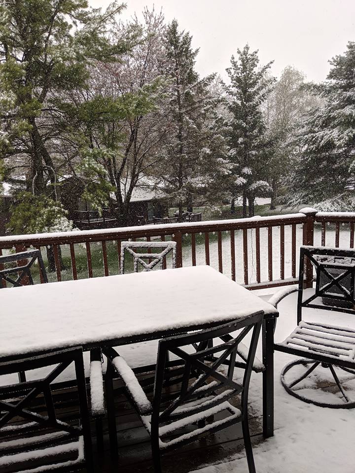
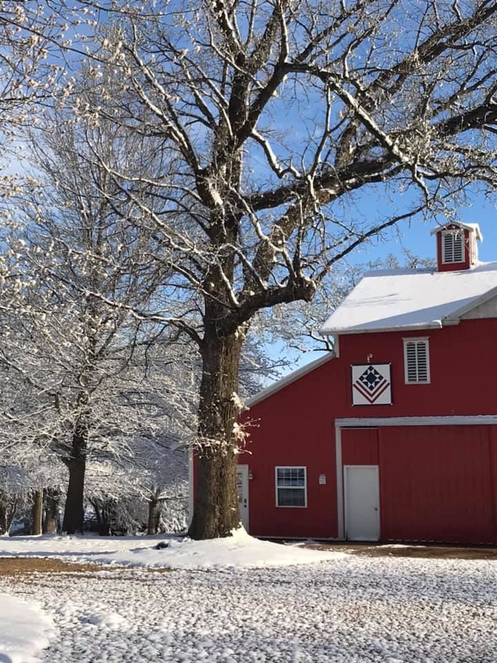
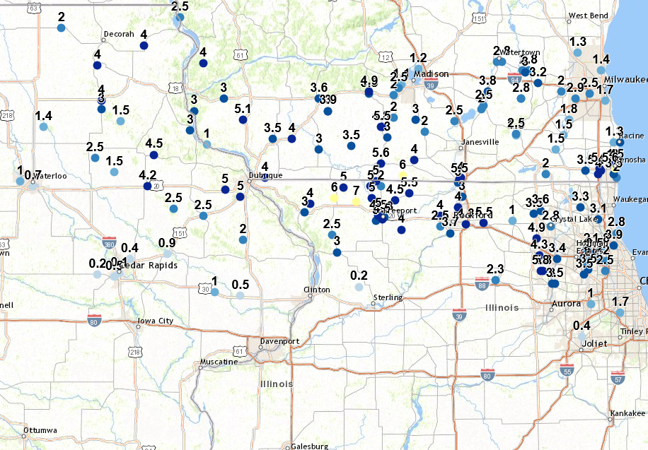
A strong Spring storm system moved from central South Dakota into the lower Ohio River Valley by Saturday evening. Precipitation began as all rain across eastern Iowa, northwest Illinois and far northeast Missouri before drier air moving into the region caused the rain to mix with and change over to all snow Saturday morning and into the afternoon along the Highway 20 corridor in Iowa and Illinois. Snowfall amounts in general ranged from 2 to 5 inches with isolated reports of 6 to 7 inches in Jo Daviess and Stephenson Counties.
Snow/Ice
 |
.png) |
 |
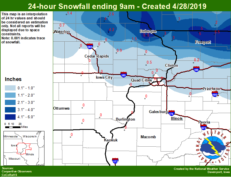 |
| National Snowfall Map | Regional Snowfall Reports Map | Local Snowfall Reports Map | Local COOP/CoCoRaHS Observer Reports 9 AM Sat. to 9 AM Sun |
 |
 |
 |
 |
| Lena, IL (Photo: Tony Runkle) |
Stockton, IL (Photo: Fred Demeter) |
Dubuque, IA (Photo: Theresa Oliver) |
Pearl City, IL (Photo: Nancy Edler ) |
Storm Reports
 |
| Interactive Map Link |
SNOW REPORTS LISTED BY AMOUNT

 INCHES  LOCATION                 ST  COUNTY           TIME
 ------  -----------------------  --  --------------   -------
  7.0    LENA                     IL  STEPHENSON       0639 AM
  6.0    3 N STOCKTON             IL  JO DAVIESS       0901 PM
  5.5    DAVIS                    IL  STEPHENSON       0800 AM
  5.3    1 E NORA                 IL  JO DAVIESS       0537 PM
  5.0    3 NNE MC CONNELL         IL  STEPHENSON       0700 AM
  5.0    2 W RED OAK              IL  STEPHENSON       0859 PM
  5.0    PEOSTA                   IA  DUBUQUE          0800 AM
  5.0    1 NW ONECO               IL  STEPHENSON       0700 AM
  5.0    2 NW FREEPORT            IL  STEPHENSON       0700 AM
  5.0    DUBUQUE REGIONAL ARPT    IA  DUBUQUE          0700 PM
  4.5    2 NW FREEPORT            IL  STEPHENSON       0650 AM
  4.5    FREEPORT                 IL  STEPHENSON       0720 PM
  4.5    DAKOTA                   IL  STEPHENSON       0800 AM
  4.2    1 SSE MANCHESTER         IA  DELAWARE         0700 AM
  4.0    2 SSE SCHAPVILLE         IL  JO DAVIESS       0738 PM
  4.0    GERMAN VALLEY            IL  STEPHENSON       0800 AM
  3.3    1 E FREEPORT             IL  STEPHENSON       1125 PM
  3.0    MOUNT CARROLL            IL  CARROLL          1007 PM
  3.0    3 ENE BOLTON             IL  STEPHENSON       0730 AM
  3.0    ELIZABETH                IL  JO DAVIESS       0630 AM
  2.5    4 W STANLEY              IA  BUCHANAN         1225 AM
  2.5    6 SSE ELMOVILLE          IL  CARROLL          0700 AM
  2.5    HOPKINTON                IA  DELAWARE         0554 PM
  2.5    FREEPORT                 IL  STEPHENSON       0523 PM
  2.5    CASCADE                  IA  DUBUQUE          0510 PM
  2.0    1 WNW FULTON             IA  JACKSON          0900 AM
  1.5    5 SW LAMONT              IA  BUCHANAN         0900 AM
  1.0    LOWDEN                   IA  CEDAR            1200 AM
  0.9    2 E FAIRVIEW             IA  JONES            0609 PM
  0.5    2 WSW CEDAR RAPIDS       IA  LINN             0745 AM
  0.5    2 NE CALAMUS             IA  CLINTON          0700 AM
  0.4    1 N MARION               IA  LINN             0500 PM
  0.2    3 SSE ATKINS             IA  BENTON           0700 AM
  0.2    1 SSW COLETA             IL  WHITESIDE        0700 AM
  0.1    CEDAR RAPIDS             IA  LINN             0320 PM
PRELIMINARY LOCAL STORM REPORT...SUMMARY
NATIONAL WEATHER SERVICE QUAD CITIES IA IL
242 PM CDT SUN APR 28 2019

..TIME...   ...EVENT...      ...CITY LOCATION...     ...LAT.LON...
..DATE...   ....MAG....      ..COUNTY LOCATION..ST.. ...SOURCE....
            ..REMARKS..

0639 AM     SNOW             LENA                    42.38N 89.83W
04/28/2019  E7.0 INCH        STEPHENSON         IL   PUBLIC

            A PUBLIC REPORT VIA SOCIAL MEDIA!.

0901 PM     SNOW             3 N STOCKTON            42.40N 90.00W
04/27/2019  M6.0 INCH        JO DAVIESS         IL   CO-OP OBSERVER

            STORM TOTAL - SNOW ACCUMULATED IN GRASSY
            AREAS NO ROAD IMPACTS.

0800 AM     SNOW             DAVIS                   42.43N 89.42W
04/28/2019  M5.5 INCH        STEPHENSON         IL   COCORAHS

            COCORAHS STATION IL-SP-7 DAVIS 0.5 N.

0537 PM     SNOW             1 E NORA                42.46N 89.93W
04/27/2019  M5.3 INCH        JO DAVIESS         IL   TRAINED SPOTTER

            CORRECTS PREVIOUS SNOW REPORT FROM 1 E NORA.
            MOSTLY ON GRASSY AND ELEVATED SURFACES.

0700 PM     SNOW             DUBUQUE REGIONAL ARPT   42.41N 90.73W
04/27/2019  M5.0 INCH        DUBUQUE            IA   OFFICIAL NWS OBS

            24 HOUR SNOW TOTAL.

0700 AM     SNOW             2 NW FREEPORT           42.31N 89.66W
04/28/2019  M5.0 INCH        STEPHENSON         IL   COCORAHS

            COCORAHS STATION IL-SP-6 FREEPORT 2.0 NW.

0700 AM     SNOW             1 NW ONECO              42.50N 89.68W
04/28/2019  M5.0 INCH        STEPHENSON         IL   COCORAHS

            COCORAHS STATION IL-SP-3 ORANGEVILLE 2.8 NW.

0800 AM     SNOW             PEOSTA                  42.45N 90.85W
04/28/2019  E5.0 INCH        DUBUQUE            IA   PUBLIC

            STORM TOTAL ESTIMATE 5+ INCHES PAST 24
            HOURS.

0859 PM     SNOW             2 W RED OAK             42.40N 89.71W
04/27/2019  M5.0 INCH        STEPHENSON         IL   PUBLIC


0700 AM     SNOW             3 NNE MC CONNELL        42.47N 89.72W
04/28/2019  M5.0 INCH        STEPHENSON         IL   COCORAHS

            COCORAHS STATION IL-SP-8 WINSLOW 4.3 ESE.

0800 AM     SNOW             DAKOTA                  42.39N 89.53W
04/28/2019  E4.5 INCH        STEPHENSON         IL   PUBLIC

            ESTIMATED 4 TO 5 INCHES STORM TOTAL PAST 24
            HOURS.

0720 PM     SNOW             FREEPORT                42.28N 89.63W
04/27/2019  M4.5 INCH        STEPHENSON         IL   TRAINED SPOTTER


0650 AM     SNOW             2 NW FREEPORT           42.30N 89.66W
04/28/2019  M4.5 INCH        STEPHENSON         IL   COCORAHS

            COCORAHS STATION IL-SP-25 FREEPORT 1.7 NW.

0700 AM     SNOW             1 SSE MANCHESTER        42.47N 91.45W
04/28/2019  M4.2 INCH        DELAWARE           IA   CO-OP OBSERVER

            CO-OP OBSERVER STATION MHRI4 MANCHESTER.

0800 AM     SNOW             GERMAN VALLEY           42.22N 89.48W
04/28/2019  E4.0 INCH        STEPHENSON         IL   PUBLIC

            ESTIMATED 4 INCHES STORM TOTAL PAST 24
            HOURS.

0738 PM     SNOW             2 SSE SCHAPVILLE        42.37N 90.19W
04/27/2019  M4.0 INCH        JO DAVIESS         IL   TRAINED SPOTTER


1125 PM     SNOW             1 E FREEPORT            42.29N 89.61W
04/27/2019  E3.3 INCH        STEPHENSON         IL   TRAINED SPOTTER


0630 AM     SNOW             ELIZABETH               42.32N 90.23W
04/28/2019  M3.0 INCH        JO DAVIESS         IL   CO-OP OBSERVER

            CO-OP OBSERVER STATION EZBI2 ELIZABETH.

0730 AM     SNOW             3 ENE BOLTON            42.27N 89.68W
04/28/2019  M3.0 INCH        STEPHENSON         IL   COCORAHS

            COCORAHS STATION IL-SP-26 FREEPORT 2.9 WSW.

1007 PM     SNOW             MOUNT CARROLL           42.09N 89.98W
04/27/2019  M3.0 INCH        CARROLL            IL   PUBLIC

            STORM TOTAL SNOW WITH A LITTLE SLEET PAST 24
            HOURS.

0510 PM     SNOW             CASCADE                 42.30N 91.02W
04/27/2019  E2.5 INCH        DUBUQUE            IA   PUBLIC

            KCRG VIEWER REPORTED 2.5 INCHES ESTIMATED IN
            THE CASCADE AREA.

0523 PM     SNOW             FREEPORT                42.28N 89.63W
04/27/2019  M2.5 INCH        STEPHENSON         IL   TRAINED SPOTTER


0554 PM     SNOW             HOPKINTON               42.34N 91.25W
04/27/2019  M2.5 INCH        DELAWARE           IA   TRAINED SPOTTER

            ACCUMULATIONS ON GRASSY SURFACES, LITTLE TO
            NONE ON SIDEWALKS AND ROADS.

0700 AM     SNOW             6 SSE ELMOVILLE         42.19N 90.02W
04/28/2019  M2.5 INCH        CARROLL            IL   COCORAHS

            COCORAHS STATION IL-CR-12 MOUNT CARROLL 6.8
            NNW.

1225 AM     SNOW             4 W STANLEY             42.63N 91.86W
04/28/2019  M2.5 INCH        BUCHANAN           IA   CO-OP OBSERVER


0900 AM     SNOW             1 WNW FULTON            42.16N 90.71W
04/28/2019  M2.0 INCH        JACKSON            IA   CO-OP OBSERVER

            CO-OP OBSERVER STATION FULI4 FULTON.

0900 AM     SNOW             5 SW LAMONT             42.55N 91.71W
04/28/2019  M1.5 INCH        BUCHANAN           IA   COCORAHS

            COCORAHS STATION IA-BC-9 WINTHROP 5.6 NNE.

1200 AM     SNOW             LOWDEN                  41.86N 90.93W
04/28/2019  M1.0 INCH        CEDAR              IA   TRAINED SPOTTER

            STORM TOTAL PAST 24 HOURS.

0609 PM     SNOW             2 E FAIRVIEW            42.08N 91.30W
04/27/2019  M0.9 INCH        JONES              IA   TRAINED SPOTTER


0700 AM     SNOW             2 NE CALAMUS            41.84N 90.73W
04/28/2019  M0.5 INCH        CLINTON            IA   COCORAHS

            COCORAHS STATION IA-CN-2 CALAMUS 2.0 NE.

0745 AM     SNOW             2 WSW CEDAR RAPIDS      41.95N 91.71W
04/28/2019  M0.5 INCH        LINN               IA   COCORAHS

            COCORAHS STATION IA-LN-39 CEDAR RAPIDS 2.5
            WSW.

0500 PM     SNOW             1 N MARION              42.05N 91.59W
04/27/2019  M0.4 INCH        LINN               IA   CO-OP OBSERVER

            CO-OP OBSERVER STATION CRPI4 CEDAR RAPIDS
            NO. 1.

0700 AM     SNOW             1 SSW COLETA            41.89N 89.81W
04/28/2019  M0.2 INCH        WHITESIDE          IL   COCORAHS

            COCORAHS STATION IL-WD-8 COLETA 1.4 SSW.

0700 AM     SNOW             3 SSE ATKINS            41.96N 91.84W
04/28/2019  M0.2 INCH        BENTON             IA   COCORAHS

            COCORAHS STATION IA-BT-12 FAIRFAX 4.0 NW.

0320 PM     SNOW             CEDAR RAPIDS            41.97N 91.67W
04/27/2019  E0.1 INCH        LINN               IA   TRAINED SPOTTER

            MIXED PRECIPITATION CHANGING OVER TO SNOW
            AND STARTING TO STICK ON CARS.
 |
Media use of NWS Web News Stories is encouraged! Please acknowledge the NWS as the source of any news information accessed from this site. |
|