Overview
A rare wake low wind event moved across eastern Iowa and northwest Illinois late Tuesday night into Wednesday morning. Sustained winds over 40 mph and gusts over 60 mph occurred from 11 pm Wednesday to 4 am Thursday. These strong winds caused downed trees, power outages, and some minor structural damage to buildings. For a complete definition of a wake low, click here.Warning Information
| Warning Area | |
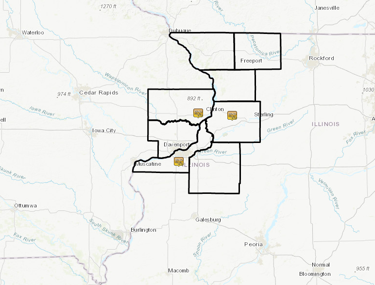 |
URGENT - WEATHER MESSAGE
NATIONAL WEATHER SERVICE QUAD CITIES IA IL
1118 PM CDT TUE MAY 21 2019

...HIGH WINDS EXPECTED...

.HIGH WINDS UP TO 60 MPH WILL OCCUR AS THE RAIN ENDS. POWER
OUTAGES AND TREE DAMAGE IS LIKELY!

ILZ001-002-007-220600-
/O.EXB.KDVN.HW.W.0002.000000T0000Z-190522T0600Z/
JO DAVIESS-STEPHENSON-CARROLL-
INCLUDING THE CITIES OF GALENA, FREEPORT, AND MOUNT CARROLL
1118 PM CDT TUE MAY 21 2019

...HIGH WIND WARNING IN EFFECT UNTIL 1 AM CDT WEDNESDAY...

THE NATIONAL WEATHER SERVICE IN QUAD CITIES HAS ISSUED A HIGH
WIND WARNING, WHICH IS IN EFFECT UNTIL 1 AM CDT WEDNESDAY.

* WINDS...40 MPH SUSTAINED GUSTING TO 60 MPH.

* TIMING...THROUGH 1 AM

* IMPACTS...DAMAGE TO TREES AND POWERLINES IS EXPECTED.

PRECAUTIONARY/PREPAREDNESS ACTIONS...

A HIGH WIND WARNING MEANS THAT SUSTAINED WIND SPEEDS OF AT LEAST
40 MPH OR GUSTS OF 58 MPH OR MORE WILL OCCUR.  THIS CAN LEAD TO
PROPERTY DAMAGE AND WILL MAKE DRIVING VERY HAZARDOUS, ESPECIALLY
FOR HIGH PROFILE VEHICLES ON NORTH-SOUTH ROADS.

&&

$$

IAZ066-068-ILZ009-015-016-220530-
/O.CON.KDVN.HW.W.0002.000000T0000Z-190522T0500Z/
CLINTON-SCOTT-WHITESIDE-ROCK ISLAND-HENRY IL-
INCLUDING THE CITIES OF CLINTON, DAVENPORT, BETTENDORF, STERLING,
MOLINE, ROCK ISLAND, AND GENESEO
1118 PM CDT TUE MAY 21 2019

...HIGH WIND WARNING REMAINS IN EFFECT UNTIL MIDNIGHT CDT
TONIGHT...

* WINDS...40 MPH SUSTAINED GUSTING TO 60 MPH.

* TIMING...THROUGH MIDNIGHT

* IMPACTS...DAMAGE TO TREES AND POWERLINES IS EXPECTED.

PRECAUTIONARY/PREPAREDNESS ACTIONS...

A HIGH WIND WARNING MEANS THAT SUSTAINED WIND SPEEDS OF AT LEAST
40 MPH OR GUSTS OF 58 MPH OR MORE WILL OCCUR.  THIS CAN LEAD TO
PROPERTY DAMAGE AND WILL MAKE DRIVING VERY HAZARDOUS, ESPECIALLY
FOR HIGH PROFILE VEHICLES ON NORTH-SOUTH ROADS.
Storm Reports
| Interactive Storm Map | |
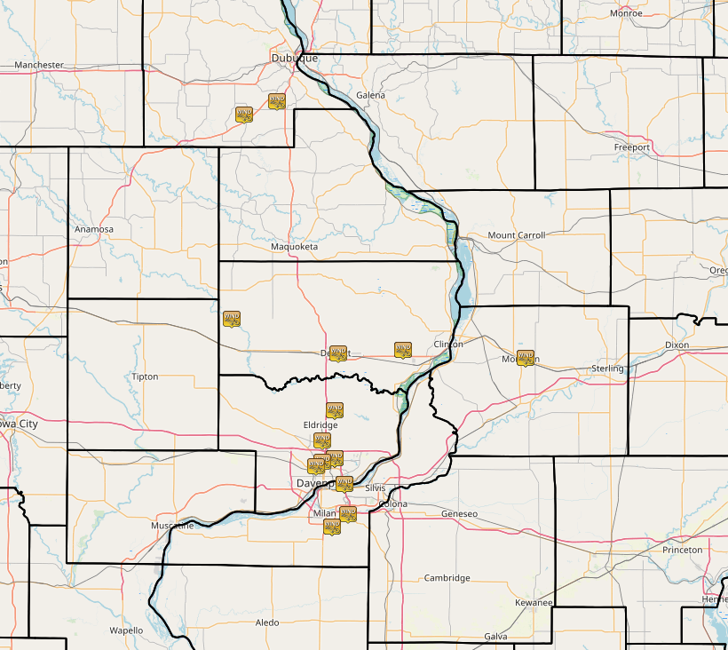 |
PRELIMINARY LOCAL STORM REPORT...SUMMARY
NATIONAL WEATHER SERVICE QUAD CITIES IA IL
1259 AM CDT WED MAY 22 2019

..TIME...   ...EVENT...      ...CITY LOCATION...     ...LAT.LON...
..DATE...   ....MAG....      ..COUNTY LOCATION..ST.. ...SOURCE....
            ..REMARKS..

1155 PM     NON-TSTM WND DMG 1 ENE MORRISON          41.81N 89.95W
05/21/2019                   WHITESIDE          IL   TRAINED SPOTTER

            TREE DOWN ON HOUSE.

1120 PM     NON-TSTM WND GST CLINTON MUNICIPAL AIRPO 41.83N 90.33W
05/21/2019  M60 MPH          CLINTON            IA   AWOS

            FROM AWOS.

1106 PM     NON-TSTM WND GST DUBUQUE REGIONAL AIRPOR 42.40N 90.72W
05/21/2019  M59 MPH          DUBUQUE            IA   ASOS

            FROM ASOS.

1045 PM     NON-TSTM WND DMG PARK VIEW               41.69N 90.54W
05/21/2019                   SCOTT              IA   NWS EMPLOYEE

            DELAYED REPORT. 6 INCH DIAMETER LIMB DOWN ON
            STREET.

1042 PM     NON-TSTM WND DMG PARK VIEW               41.69N 90.54W
05/21/2019                   SCOTT              IA   TRAINED SPOTTER

            POWER OUT.

1040 PM     NON-TSTM WND GST CLINTON MUNICIPAL AIRPO 41.83N 90.33W
05/21/2019  M53 MPH          CLINTON            IA   AWOS

            SUSTAINED 48 MPH WINDS GUSTING 53 MPH.

1040 PM     NON-TSTM WND GST 4 SSW BETTENDORF        41.52N 90.51W
05/21/2019  M59 MPH          SCOTT              IA   DEPT OF HIGHWAYS

            IA DOT RWIS.

1036 PM     NON-TSTM WND GST 4 WNW BETTENDORF        41.58N 90.54W
05/21/2019  E55 MPH          SCOTT              IA   TRAINED SPOTTER

            BLEW GRILL OFF DECK.

1036 PM     NON-TSTM WND DMG 2 S MOUNT JOY           41.58N 90.54W
05/21/2019                   SCOTT              IA   TRAINED SPOTTER

            SEVERAL TREE LIMBS DOWN IN YARD.

1035 PM     NON-TSTM WND GST MOLINE QUAD-CITY AIRPOR 41.45N 90.50W
05/21/2019  M58 MPH          ROCK ISLAND        IL   ASOS

            FROM ASOS.

1030 PM     NON-TSTM WND GST DAVENPORT MUNICIPAL AIR 41.62N 90.58W
05/21/2019  M58 MPH          SCOTT              IA   ASOS

            FROM ASOS.
PRELIMINARY LOCAL STORM REPORT...SUMMARY
NATIONAL WEATHER SERVICE QUAD CITIES IA IL
1215 PM CDT WED MAY 22 2019

..TIME...   ...EVENT...      ...CITY LOCATION...     ...LAT.LON...
..DATE...   ....MAG....      ..COUNTY LOCATION..ST.. ...SOURCE....
            ..REMARKS..

1155 PM     NON-TSTM WND DMG 1 ENE MORRISON          41.81N 89.95W
05/21/2019                   WHITESIDE          IL   TRAINED SPOTTER

            TREE DOWN ON HOUSE.

1117 PM     NON-TSTM WND DMG DAVENPORT               41.56N 90.60W
05/21/2019                   SCOTT              IA   BROADCAST MEDIA

            DOWNED TREES AND POWER LINES CREATED
            NUMEROUS POWER OUTAGES ACROSS PARTS OF THE
            IOWA AND ILLINOIS QUAD CITIES.

1110 PM     NON-TSTM WND DMG TORONTO                 41.90N 90.86W
05/21/2019                   CLINTON            IA   PUBLIC

            POWER LINES AND TREES DAMAGED BY STRONG WIND
            (TIME ESTIMATED).

1045 PM     NON-TSTM WND DMG PARK VIEW               41.69N 90.54W
05/21/2019                   SCOTT              IA   NWS EMPLOYEE

            DELAYED REPORT. 6 INCH DIAMETER LIMB DOWN ON
            STREET.

1045 PM     NON-TSTM WND DMG 1 ENE DAVENPORT         41.57N 90.58W
05/21/2019                   SCOTT              IA   NEWSPAPER

            AN ANTENNA TOWER ON NORTHWEST BANK WAS
            DAMAGED.

1042 PM     NON-TSTM WND DMG PARK VIEW               41.69N 90.54W
05/21/2019                   SCOTT              IA   TRAINED SPOTTER

            POWER OUT.

1040 PM     NON-TSTM WND DMG 4 N BERNARD             42.37N 90.82W
05/21/2019                   DUBUQUE            IA   EMERGENCY MNGR

            STRONG NON-THUNDERSTORM WINDS BLEW A SMALL
            UTILITY SHED OFF ITS SLAB, SNAPPED A ROUGHLY
            1 FOOT DIAMETER PINE TREE AT GROUND LEVEL,
            AND OVERTURNED THREE 300 POUND FEED BUNKS.
            TIME ESTIMATED BY RADAR.

1040 PM     NON-TSTM WND DMG 1 E DEWITT              41.82N 90.53W
05/21/2019                   CLINTON            IA   NEWSPAPER

            TIN ROOF PARTLY PEELED OFF OF THE 4H
            AUDITORIUM AT THE FAIRGROUNDS AND SEVERAL
            TREE BRANCHES DOWN AROUND TOWN. (TIME
            ESTIMATED).

1036 PM     NON-TSTM WND DMG 2 S MOUNT JOY           41.58N 90.54W
05/21/2019                   SCOTT              IA   TRAINED SPOTTER

            SEVERAL TREE LIMBS DOWN IN YARD.
 |
Media use of NWS Web News Stories is encouraged! Please acknowledge the NWS as the source of any news information accessed from this site. |
|

