Dangerous heat will expand from the Gulf Coast into the Southern Plains and Desert Southwest through week's end. Additional extreme heat impacting the Pacific Northwest will shift to the northern Plains by the weekend. Tropical Storm Bertha is expected to continue to impact portions of the northern Gulf Coast from the western Florida Panhandle to southeastern Louisiana through tonight. Read More >
Overview
|
A warm front lifted northward into the area Friday, May 24, sparking some thunderstorms in the morning/early afternoon time frame and again in the early evening. Two tornadoes were occurred in McDonough County during the early afternoon. Towards evening, another tornadic storm developed, producing two tornados. The first in Johnson County just southwest of Iowa City, and the second in Cedar County just north of West Branch.
KML Link: All Tornadoes |
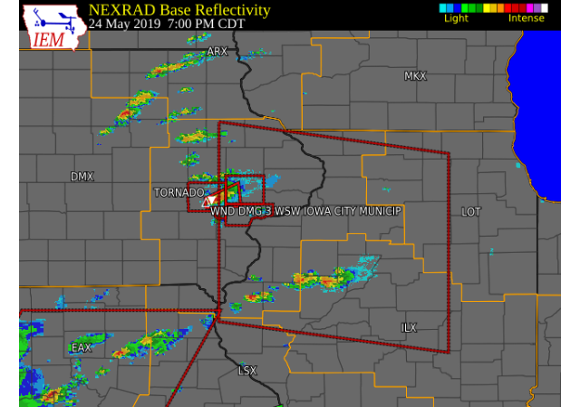 9:15 PM Radar Image |
Tornadoes:
|
Tornado #1 - ~3 N INDUSTRY, IL
Track Map 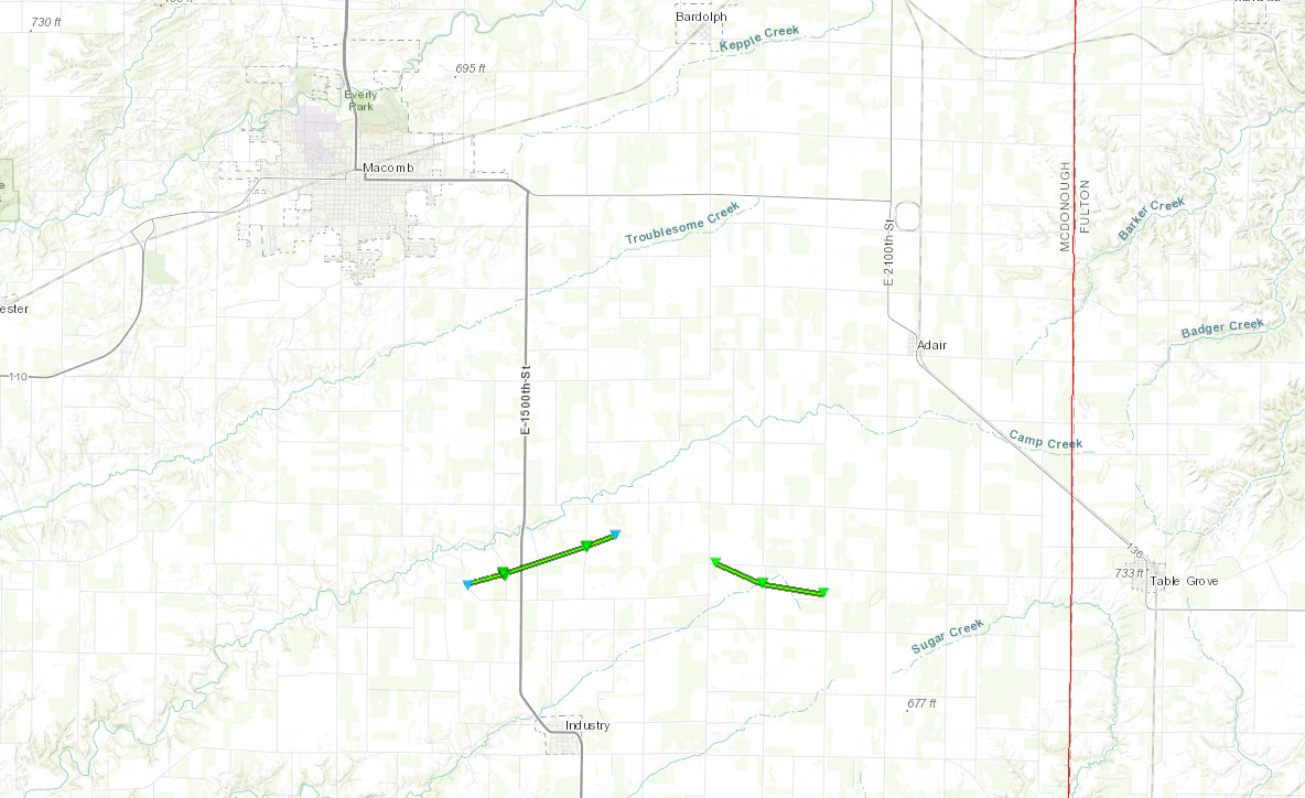 
|
||||||||||||||||
|
Tornado #2 - ~4.3 NE INDUSTRY, IL
Track Map
|
||||||||||||||||
|
Tornado #3 - IOWA CITY, IA
Track Map 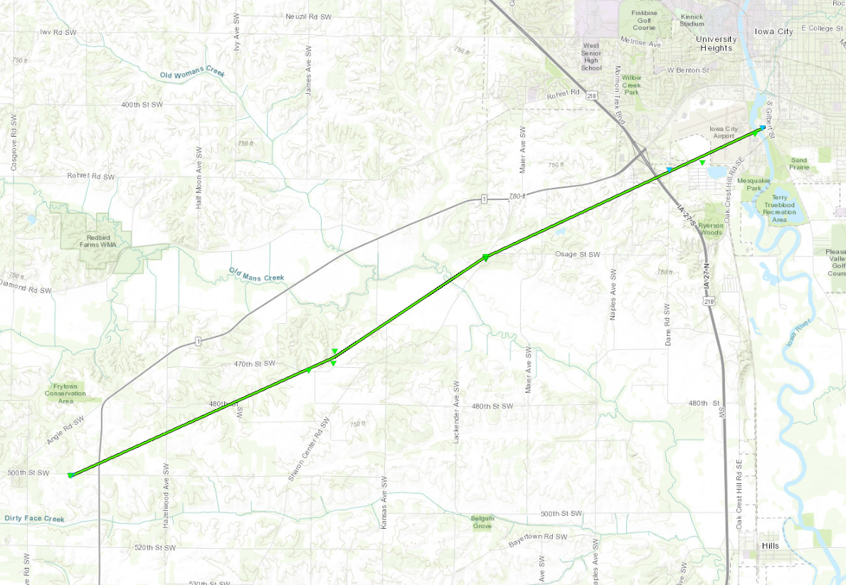
|
||||||||||||||||
|
Tornado #4 - NE West Branch, IA
Track Map 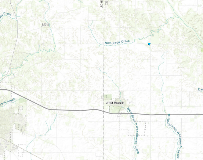
|
||||||||||||||||
The Enhanced Fujita (EF) Scale classifies tornadoes into the following categories:
| EF0 Weak 65-85 mph |
EF1 Moderate 86-110 mph |
EF2 Significant 111-135 mph |
EF3 Severe 136-165 mph |
EF4 Extreme 166-200 mph |
EF5 Catastrophic 200+ mph |
 |
|||||
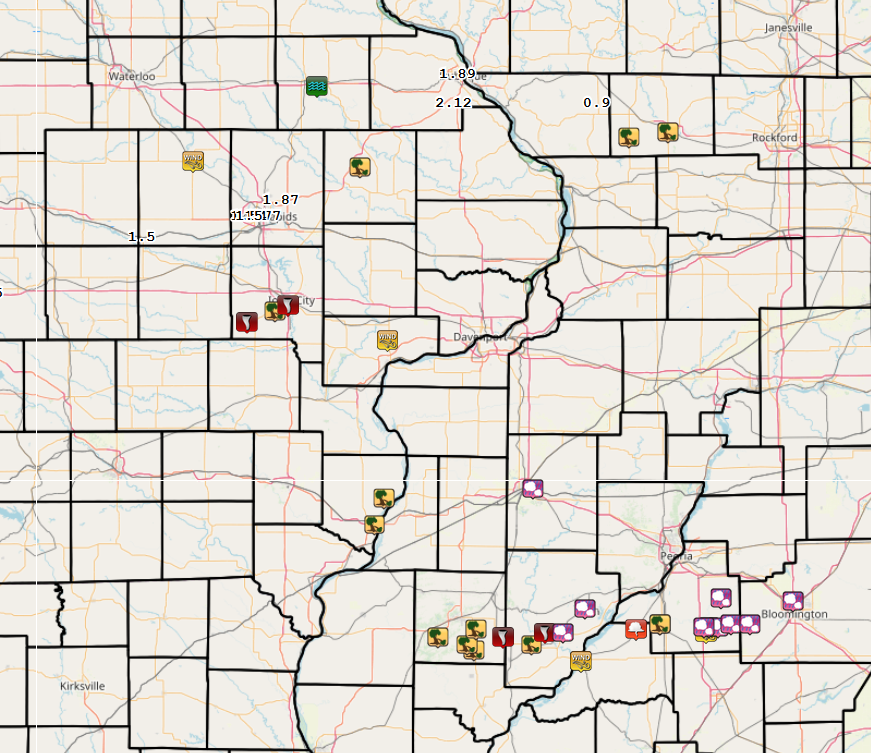
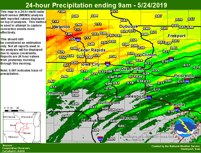
Rain Reports
 |
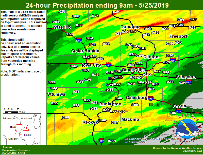 |
| Local Rainfall 5/23-5/24 | Local Rainfall 5/24-5/25 |
24 hour precipitation reports (in Inches), for eastern Iowa, northwest and west central Illinois, and northeast Missouri. Reported between Midnight and 9 AM, Friday May 24, 2019. ....IOWA.... NWS Johnston* 5 NNW 2.42 Perry 0 W 2.36 Marshalltown ASOS 4 N 1.95 Marshalltown 1 NW 1.83 Boone 1 SSW 1.81 Vinton 1.55 Independence 1.2 N 1.46 Toledo 3 N 1.31 Center Point 0.6 NNW 1.29 Hampton 1 N 1.20 Waterloo ASOS 5 NW 1.14 Independence 0.9 WNW 1.12 Manchester 1.1 N 1.12 Central City 6.7 W 1.11 Ames US 30 2 SSE 1.09 Tripoli 0 N 1.06 Mount Auburn 2.2 NNW 1.04 Coggon 1.02 Maquoketa 4 W 0.98 Hopkinton 5.4 WSW 0.98 Anamosa 3 SSW 0.97 Anamosa 1.9 SE 0.97 Mason City 1 NNE 0.95 Monticello 1 E 0.95 Center Junction 2.6 W 0.95 Williamsburg 0.95 Cascade 0.93 Beaconsfield 1 NNE 0.92 Fayette 1 NW 0.90 Rickardsville 0.2 W 0.87 Fairfax 4.0 NW 0.86 Marion 1.7 NNW 0.86 Strawberry Point 0.84 Mason City ASOS 6 W 0.84 Ely 0.5 SE 0.84 Iowa City Arpt 0.83 North English 0.83 Bellevue LD12 0.80 Asbury 0.4 SW 0.79 Belle Plaine 0.79 Swisher 0.78 Dubuque LD11 0.78 Solon 0.3 ESE 0.78 Peosta 2.9 E 0.78 Parnell 0.1 SSW 0.77 Guttenberg Dam 10 0.75 Dubuque Arpt 7 SW 0.75 Grinnell AWOS 2 SSW 0.75 Calamus 2.0 NE 0.70 Cresco 1 NE 0.68 Delmar 2.3 NW 0.66 Charlotte 1.9 WNW 0.59 West Branch 2.0 NNW 0.56 Marengo 2.6 SSW 0.55 Marengo 0.54 Tipton 0.7 N 0.54 Fulton 0.54 Kalona 7.3 NNW 0.52 Cedar Rapids Arpt 5 SW 0.48 Oskaloosa AWOS 9 ESE 0.47 Pella 4 N 0.46 Sigourney 0.40 Iowa City 0.36 Riverdale 0.5 N 0.33 Nichols 3.2 SSW 0.32 Bettendorf 2.2 SE 0.32 Donnellson 0.32 Oskaloosa 1 NNW 0.31 Davenport 0.9 WNW 0.31 Davenport 0.9 SSW 0.30 Pella AWOS 2 WSW 0.30 Le Claire 1.8 NNE 0.27 Camanche 1.2 W 0.25 Le Claire LD14 0.25 Park View 0.2 WSW 0.24 De Witt 0.23 Ainsworth 7.4 N 0.21 Eldridge 0.6 ESE 0.20 Eldridge 0.6 S 0.20 Bettendorf 1.6 WSW 0.20 Wellman 4.0 E 0.19 Washington 0.19 Eldridge 0.7 SSW 0.18 Albia 3 NNE 0.13 Ottumwa ASOS 6 NNW 0.11 Morning Sun 1.7 E 0.10 Davenport Arpt 5 N 0.10 Wapello 0.2 S 0.09 Muscatine 2N 0.09 Muscatine 2.1 N 0.08 Rathbun Reservoir 2 N 0.02 Salem 1S 0.01 Burlington Arpt 2 SW 0.01 New London 1.5 SW 0.00 Centerville 0 NE 0.00 Keosauqua 0.00 Fairfield 0.00 Keokuk LD19 0.00 Fairfield 0.6 E 0.00 Burlington 6.5 SSW 0.00 Oelwein AWOS 0.00 ....ILLINOIS.... Winslow 4.3 ESE 0.93 Stockton 3.4 NNE 0.91 Rockford ASOS 0.89 Milan 8.8 SSW 0.71 Elizabeth 0.71 Galena 0.69 Mount Carroll 0.67 Ridott 0.1 NE 0.66 Davis 0.5 N 0.66 Dakota 4.8 NW 0.65 Freeport 2.9 WSW 0.63 Shannon 0.2 S 0.62 Pearl City 0.4 SW 0.62 Freeport 2.0 NW 0.60 Freeport 0.55 Moline 0.7 NNE 0.54 Freeport 1.7 ESE 0.50 Woodhull 0.3 ESE 0.46 Milledgeville 0.6 NW 0.45 New Boston LD17 0.43 Mundelein 0.40 Roscoe 2SE 0.40 Lanark 1.6 SSE 0.39 Coal Valley 1.9 SE 0.39 Coal Valley 2.6 E 0.34 New Windsor 2.0 N 0.34 Alpha 2.3 N 0.33 Geneseo 2.0 NW 0.33 Ill. City LD16 3 WNW 0.30 Coleta 1.4 SSW 0.27 Quad City Arpt 3 S 0.26 Romeoville 0.26 Paw Paw 1 E 0.24 La Moille 0.2 NNE 0.23 Ottawa 4 SW 0.20 Illinois City 6.7 SW 0.20 Rochelle 0.20 Quincy Dam 21 0.19 Aledo 0.18 Princeton 1.1 SE 0.18 Gladstone LD18 0.18 Mendota 2 SE 0.18 Princeton 0.18 Tiskilwa 2.1 N 0.17 Sterling 4.9 WSW 0.17 Peoria ASOS 0.16 Streator 3 SE 0.15 Bloomington Airport 0.14 Galesburg 0.12 Walnut 5.3 ENE 0.12 Altona 0.12 Galva 2.7 NE 0.11 Rochelle AWOS 0.11 Prophetstown 0.2 SW 0.10 Galesburg Arpt 3 SW 0.09 Steward 0.08 Augusta 0.05 Kewanee 1 E 0.05 Macomb 0.04 Windsor 0.03 Bentley 0.03 Colchester 3.5 NE 0.03 Joliet 0.03 Macomb 3.8 NW 0.03 Tuscola 0.01 Ogden 0.00 Quincy ASOS 0.00 Lincoln NWS 0.00 Decatur Airport 0.00 La Harpe 0.00 Jacksonville AWOS 0.00 Monmouth 4NW 0.00 Dallas City 3.0 SSE 0.00 St Anne 0.00 ....MISSOURI.... Canton LD20 0.04 Memphis 0.00 Kirksville ASOS 0.00 Chillicothe 2 NW 0.00 Columbia 0.00 ....WISCONSIN.... Monroe 1 W 0.76 Prairie du Chien AWOS 0.72 Darlington 0.67 Brodhead 1 SW 0.57 Beloit-College 0.43 Viroqua 0.43 Whitewater 0.40 Steuben 4SE 3 NE 0.34 La Crosse WFO 0.28 Madison-ASOS 0.27 Allenton-WWTP .6 NW 0.12 Watertown-AWOS 0.00 ....MINNESOTA.... Preston 0.29 Theilman 1SSW 0.28 |
24 hour precipitation reports (in Inches), for eastern Iowa, northwest and west central Illinois, and northeast Missouri. Reported between Midnight and 9 AM, Saturday May 25, 2019. ....IOWA.... Mount Auburn 2.2 NNW 1.50 Dubuque Arpt 7 SW 1.37 Guttenberg Dam 10 1.26 Dubuque LD11 1.10 Asbury 0.4 SW 1.10 Marion 1.7 NNW 1.04 Fayette 1 NW 1.00 Waterloo ASOS 5 NW 0.95 Allerton 2 S 0.93 Pella 4 N 0.90 Cascade 0.88 Ames US 30 2 SSE 0.84 Peosta 2.9 E 0.84 Toledo 3 N 0.81 Bellevue LD12 0.74 Solon 0.3 ESE 0.73 Center Point 0.6 NNW 0.71 Marshalltown 1 NW 0.71 Strawberry Point 0.71 Iowa City 8.0 NE 0.69 Anamosa 3 SSW 0.65 De Witt 0.64 Iowa City 0.60 Burlington 0.8 SSE 0.60 Marshalltown ASOS 4 N 0.59 Grinnell AWOS 2 SSW 0.58 Burlington 6.5 SSW 0.56 Pella AWOS 2 WSW 0.56 Burlington Arpt 2 SW 0.55 Central City 6.7 W 0.54 Tripoli 0 N 0.53 Kalona 7.3 NNW 0.51 Rathbun Reservoir 2 N 0.51 Hampton 1 N 0.48 Calamus 2.0 NE 0.46 Ottumwa ASOS 6 NNW 0.44 Burlington 2.1 S 0.43 Parnell 0.1 SSW 0.43 Maquoketa 4 W 0.42 Cedar Rapids Arpt 5 SW 0.42 Beaconsfield 1 NNE 0.41 Donnellson 0.41 Charlotte 1.9 WNW 0.41 Keosauqua 0.41 Delmar 2.3 NW 0.41 Keokuk LD19 0.40 Iowa City Arpt 0.38 Newton 1 NE 0.38 Bloomfield 1 NW 0.35 Independence 1.2 N 0.33 Cresco 1 NE 0.31 Washington 5.8 SW 0.31 Fairfield 0.31 Salem 1S 0.29 Ainsworth 7.4 N 0.25 Washington 0.24 Wapello 0.2 S 0.24 Bettendorf 1.6 WSW 0.24 Mason City 1 NNE 0.23 West Point 7.5 NW 0.23 Davenport 0.9 SSW 0.23 Oskaloosa AWOS 9 ESE 0.22 Eldridge 0.7 SSW 0.22 Mason City ASOS 6 W 0.18 Muscatine 2N 0.16 Muscatine 2.1 N 0.16 Davenport 0.9 WNW 0.16 Muscatine 2.6 NNE 0.16 NWS Johnston* 5 NNW 0.15 Bettendorf 2.2 SE 0.14 Morning Sun 1.7 E 0.14 Riverdale 0.5 N 0.13 Perry 0 W 0.09 Davenport Arpt 5 N 0.08 Boone 1 SSW 0.00 Oelwein AWOS 0.00 ....ILLINOIS.... Pearl City 0.4 SW 1.35 Orangeville 2.8 NW 1.30 La Harpe 1.10 Winslow 4.3 ESE 0.97 Freeport 2.0 NW 0.94 Davis 0.5 N 0.92 Colchester 3.5 NE 0.89 Freeport 1.7 NW 0.85 Dallas City 3.0 SSE 0.77 Freeport 0.76 Macomb 0.75 Elizabeth 0.75 Prophetstown 0.2 SW 0.73 Freeport 2.9 WSW 0.69 Galena 0.68 Stockton 3.4 NNE 0.68 Roseville 0.6 WNW 0.68 Shannon 0.2 S 0.67 Bentley 0.57 Roscoe 2SE 0.54 Coal Valley 2.6 E 0.52 Rockford ASOS 0.51 Ridott 0.1 NE 0.46 Atkinson 2.6 NNE 0.44 Quad City Arpt 3 S 0.43 Lanark 6.0 E 0.42 Gladstone LD18 0.40 Coal Valley 1.9 SE 0.40 Lanark 1.6 SSE 0.39 Galesburg Arpt 3 SW 0.38 Morrison 3.2 E 0.36 Kewanee 1 E 0.33 New Boston LD17 0.27 Geneseo 2.0 NW 0.27 Mundelein 0.21 Aledo 0.19 Alpha 2.3 N 0.17 Illinois City 6.7 SW 0.17 Rochelle AWOS 0.15 Ill. City LD16 3 WNW 0.15 Rochelle 0.13 Moline 0.7 NNE 0.11 Milan 8.8 SSW 0.09 Woodhull 4.9 E 0.09 Bloomington Airport 0.09 Woodhull 0.3 ESE 0.05 Peoria ASOS 0.05 Tiskilwa 2.1 N 0.04 New Windsor 2.0 N 0.04 Steward 0.03 Romeoville 0.00 Princeton 1.1 SE 0.00 Princeton 0.00 Quincy ASOS 0.00 Ottawa 4 SW 0.00 Decatur Airport 0.00 Jacksonville AWOS 0.00 Streator 3 SE 0.00 Joliet 0.00 St Anne 0.00 Lincoln NWS 0.00 ....MISSOURI.... Chillicothe 2 NW 0.98 Memphis 0.94 Kirksville ASOS 0.93 Columbia 0.07 ....WISCONSIN.... Madison-ASOS 2.22 Brodhead 1 SW 1.73 Allenton-WWTP .6 NW 1.10 Steuben 4SE 3 NE 1.00 Monroe 1 W 0.94 Prairie du Chien AWOS 0.79 Beloit-College 0.75 Viroqua 0.68 Whitewater 0.53 La Crosse WFO 0.52 Delavan-1 W-WWTP 1 W 0.25 Watertown-AWOS 0.00 ....MINNESOTA.... Preston 0.14 Theilman 1SSW 0.08 |
Environment
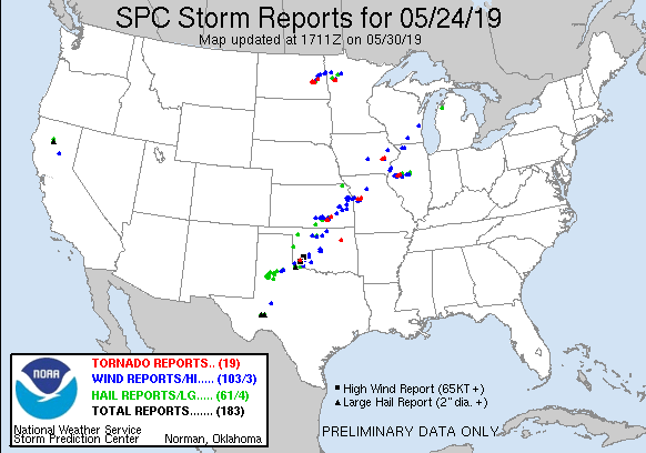
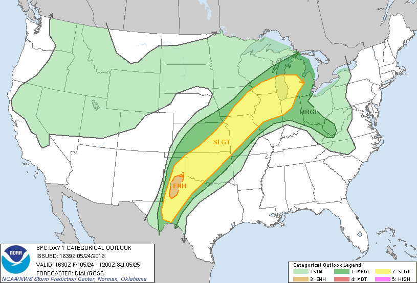
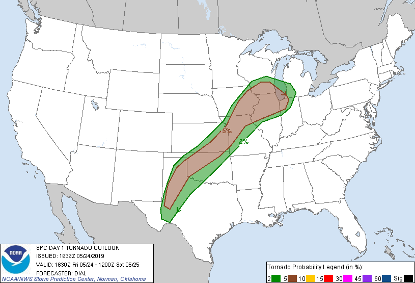
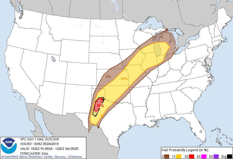
SPC EVENT SUMMARY MAY 24, 2019
 |
 |
 |
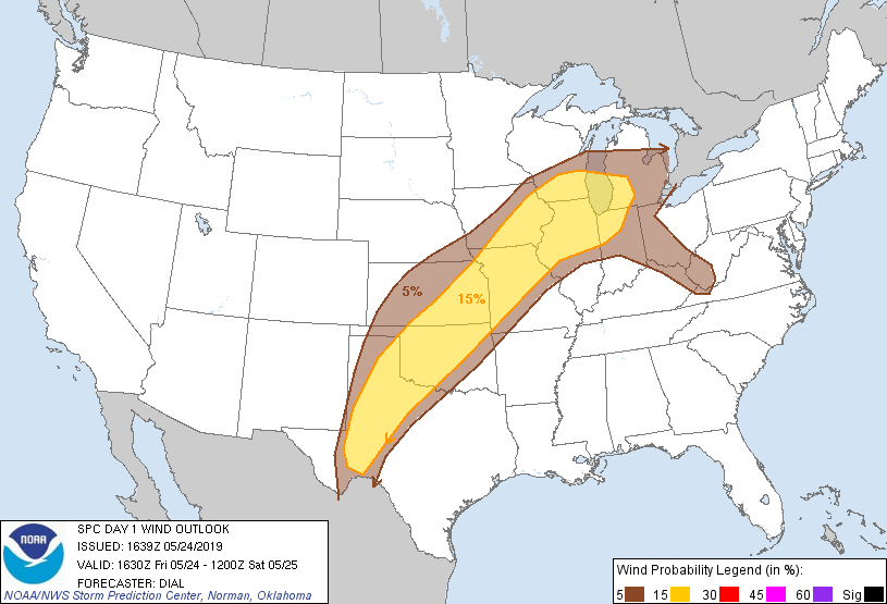 |
| Day 1 (1630z) | Day 1 Tornado | Day 1 Hail | Day 1 Wind |
 |
 |
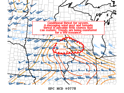 |
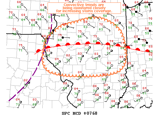
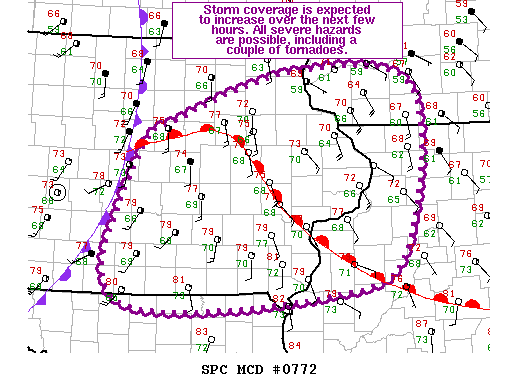
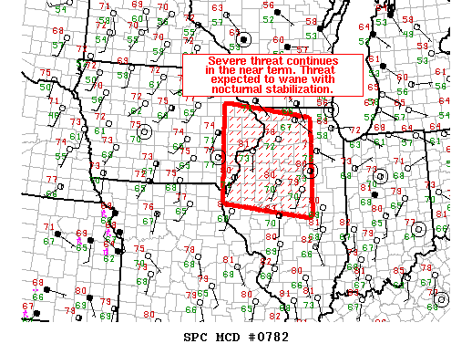
| MCD 0768 | MCD #0772 | MCD #0778 |
 |
 |
 |
 |
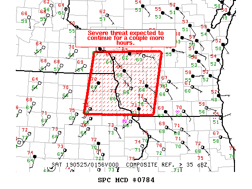
| MCD 0782 | MCD 0784 | Davenport 7 AM 5/24 Sounding |
Lincoln, IL 7 PM 5/24 Sounding |
 |
Media use of NWS Web News Stories is encouraged! Please acknowledge the NWS as the source of any news information accessed from this site. |
|